From CES to the Detroit Auto Show, it has been a big month for in-car connectivity that enables vehicle diagnostics, streaming entertainment, telematics and navigation. Ford, GM, Google and Audi unveiled new connected vehicle platforms and features, and AT&T stole the carrier limelight with LTE Connected Services.
Plus, two industry giants announced that they are working to enable vehicles to continuously record road position at accuracies of eight inches or less. Shoppers are becoming more open to sharing their personal location with retailers. And the U.S. GAO issued a report on location privacy related to vehicle technology and applications. It has been a busy month.
The first mass-marketed connected vehicle system was Ford Sync, which now boasts one million users and seems poised to grow rapidly with the release of an updated version. The Mustang will be the first of the company’s models with the new Ford Sync, which lets drivers use voice to activate iPhone and Android apps. New voice activated apps include Parkmobile, a parking space finder, and the Domino app, which lets me command my car to order a pizza, just the way I like it. GM announced its first LTE-enabled vehicles for about 10 of its models. Fast connectivity in vehicles will transform in-car experiences and hopefully not kill us.
Carrier Ringmaster. AT&T wrangled itself into the center ring of car connectivity announcements. The carrier has won a multi-year exclusive agreement to enable Telsa with high speed connectivity. Despite Audi’s collaborative relationship with T-Mobile, AT&T was able to steal some work away from T-Mobile by getting a deal to supply connectivity for some Audi models. AT&T has also teamed up with Ericsson, Amdocs, Jasper Wireless and others to create AT&T Drive, a mobile platform for developing LTE connected vehicle services.
Pathway to a Jetson Car. Two industry biggies, Continental and Here, are working together to create an end-to-end connected high-precision mapping and vehicle system offering for OEMs. The system will serve as the basis of highly automated driving functionality with the first objective of continuously determining road position to within three to eight inches. That’s quite a task. The maps will include road information that will feed vehicles with information to allow them to react to changing road conditions or speed limit changes, automatically. Continental was the first automotive supplier to be granted a test license for automated driving on public roads in Nevada.
See Me Now. The percentage of consumers willing to share their current location via GPS with retailers nearly doubled year-over-year to 36 percent, according to a new IBM study of more than 300,000 global consumers. The study distinguished four distinct groups of consumers, differentiated by their interest in and use of social, location and mobile technologies while shopping. The largest group, 40 percent of shoppers, use social, location and mobile technologies, but don’t utilize them for buying products. The second largest group, almost 30 percent of shoppers, will use these technologies for making purchases. The rest of the shoppers sit on either pole of being tech laggards or hyper technology users.
In-Car Privacy under the Microscope. The U.S. Government Accountability Office (GAO) has looked into privacy issues for in-car location-based services. The GAO examined how 10 companies are using location data and if they share it, and how the policies and practices of these companies align with industry recommended privacy practices. Each of the companies stated that they do not share personally identifiable location data with marketing companies or data brokers. The GAO found that not all of the companies were following industry recommended privacy policies. The report was prepared for the Senate Subcommittee on Privacy, Technology and the Law of the Judiciary Committee. The companies that the GAO chose to examine included TeleNav (ScoutGPS Navigation), Google Maps (Navigation), TomTom (LIVE Services), Garmin Traffic, Ford Sync, Chrysler UConnect, Honda AcuraLink, GM OnStar, Toyota (Lexus Enform and Toyota Entune), and Nissan Infiniti Connection and CARWINGS.
Retailers are Getting Closer. Qualcomm has made its Gimbal proximity beacons commercially available, which are reportedly accurate to one foot and work indoors and outdoors. Gimbal is a proximity platform for brands to engage customers’ mobile devices with contextual communication, using a combination of physical location, activity, time and personal interests. The intent is to increase the relevance of content delivered to end users’ devices to allow retailers, content providers and developers to send personalized high-value content to mobile devices.
It’s a daunting task — trying to find the big location story in a maze of 150,000 attendees and thousands of exhibitors at the International Consumer Electronics Show in Las Vegas. Aside from every automaker touting their connected vehicle efforts, the big deal this year at CES is wearable technology (last year it was 3D printing? Yawn). Despite sore feet from walking football-field lengths of booths, CES is still a cool show, blaring stereos, walls of TV screens, robots…and connected cars.
LAS VEGAS — Although the largest number of worldwide auto manufacturers attended this year’s International CES here, many industry experts believe that technology giants Google and Apple will swoop in and grab not only the market, but will control what will go into the connected automobile in the future.
“Leading IT, consumer electronics and Internet companies will marginalize specialist vendors. I’m worried that Internet companies will take over the [connected car] market — away from the auto manufacturers,” said Thilo Koslowski, Gartner vice president at the Consumer Telematics Show, held the day before CES
Koslowski’s fears have been partially validated as Google launched a partnership, called the Open Automotive Alliance, with automakers to bring the Android operating system into cars. The Google move comes after a similar announcement by Apple, which was launched to get its iOS platform into connected cars.
Initial Open Automotive Alliance members include Audi, General Motors, Honda, Hyundai and Nvidia. Apple, in its group, has Jaguar Land Rover, Volvo, Mercedes-Benz, Honda, Ferrari, Nissan, Chevrolet, Infinity, Kia, Hyundai, Opel and Acura.
“We think [Google] is a strong content partner — the deal gives [you] perspective on where we as a company are heading. Same on the Apple side,” said Charles Koch, Honda manager, new business development, at the Consumer Telematics Show.
Despite standing room-only crowds at CES during most of the connected and automated car session, Koslowski said companies need to keep the right focus on the future. “[Connected vehicles] still are not a definite market, but we will see if it is in the next 3-4 years,” he said. “HMI and user interface will be biggest differentiators. Personalization will be important, but it will also be an expected feature.”
Koslowski said the Holy Grail for connected vehicles in the future is the transition to autonomous capability. “It’s progressing very quickly. Automakers have to avoid the gold rush mentality as it may not be the treasure trove,” he said. “They have to meet expectations [about the the technology] and avoid the creepiness factor that you know too much about the consumer.”
Regardless of the future, Koslowski believes the connected vehicle is a disruptive opportunity. “I can see carriers offering a car for free in exchange for lifetime data. Less dramatic would be with an eight-year data plan,” he said. “This would probably be a smaller, less expensive vehicle than a Ferrari or Audi.”
Overall, the telematics market has gone through several market changes in the past 10 years, said Kevin Link, senior vice president and general manager, China, for Verizon Telematics. Link said that Telematics 1.0 included door unlock, navigation, automatic collision notification, call centers and navigation. “It all began with GM and Mercedes becoming springboards for the industry. Initially, there was low consumer awareness; now, it is something like 88 percent in the United States,” he said.
Outside the U.S., however, the consumer awareness for telematics drops into the single digits. “The business model, especially in the U.S., is a burden on the consumer. In China, it’s a business-to-business play, which is not a burden on the consumer, which also explains the high usage rate,” Link said.
At CES, a record nine automakers attended and exhibited: Audi, BMW, Chrysler, Ford, General Motors, Kia, Mazda, Mercedes and Toyota.
AT&T Mobility Makes Big Announcements at CES
In a pre-CES press conference, General Motors announced its first LTE-enabled vehicles — in which AT&T Mobility is powering the LTE network for GM’s OnStar service. The first LTE-enabled vehicles, which will be available this summer, are Impala, Spark, Volt, Orlando, Spark RV, Silverado, Silverado HD, Malibu, Equinox and Corvette Stingray.
AT&T also announced it will provide connectivity for Ericsson Connected Vehicle Cloud which connects to the AT&T Drive platform for automakers
“We expect about 50 million cars to be connected by 2020. The car will be another device in your life,” said Glenn Lurie, AT&T president, emerging enterprises and partnerships. “LTE in a car will get another set of application developers involved — how will they differentiate the car? It’s a global opportunity.”
Magellan and Navigation Solutions’ Nav System Features Proximity Capability
Navigation Solutions, owned by Hertz, said it is working with Magellan to offer the NeverLost 6 navigation device that features connected services — many of which offer a consumer choices based on businesses and attractions near their current location.
A number of new systems, including Magellan’s new models and Pioneer’s five NEX models, which consist of four navigation and an A/V receiver, feature connected services that allow access to navigation — even when the phone isn’t connected to a data source. This has been a sore subject for users of the free Google Maps on a phone — no Internet, no navigation.
Magellan also announced a new line of RoadMate Personal Navigation Device (PND) units featuring Easy Touch screens and an underlying Android OS to improve navigation capabilities and features.
In other CES news:
Broadcom continues to make strides in indoor and Wi-Fi position with several new product rollouts. The company also is rolling out its BCM47531 GNSS chip that can grab signals from five satellite constellations at the same time (GPS, GLONASS, QZSS, SBAS and BeiDou), said Mohamed Awad, Broadcom director, product marketing.
Alpine rolled out the aftermarket’s first 9-inch navigation system, which will cost $2,600 and be available in June. The company is targeting used trucks and other vehicles as they are staying on the road longer, said Melvin Diaz, Alpine product planning manager.
In its press conference at CES, Kenwood said its navigation units are selling well. Its flagship, a $1,500, 7-inch system, features INRIX traffic and Garmin navigation.
In the LBS Insider February blog, several industry experts will be interviewed about the future of the autonomous vehicle.
It’s truly mind-boggling when I think of how early we are in the technology adoption curve — not just for geospatial technology, but technology in general. On the one hand, it’s scary to think about how much technology might penetrate and be further integrated into our lives, on the verge of threatening our privacy if we let it. On the other hand, it’s frustrating to think about how crashes, crimes and catastrophes can be avoided or minimized if today’s technology was deployed.
Crashes. There is no reason that something like the Asiana Airlines crash at the San Francisco International Airport or the Southwest Airlines Boeing 737 landing at the wrong airport in Branson, Missouri, earlier this month should have ever happened. Technology exists today that can prevent these sorts of incidents and tragedies caused by human error, and prevent some that are not caused by human error.
Simply put, if my automotive GPS receiver can steer me to the correct McDonald’s (one of many) within a city, there’s no reason a GPS receiver (with a current airport database) can’t guide a pilot to the correct airport. If I can load a CAD model into a bulldozer machine-control system and have it grade the surface material to within a few centimeters, a similar GPS system can certainly assist in landing an airliner at the San Francisco airport without hitting the sea wall.
Thinking on a broader scale, there is no reason that the vast majority of vehicle crashes should occur. That’s right, something that occurs every day and in every city in the world, causing billions of dollars of economic loss each year, should never happen. At a minimum, high-speed laser rangefinders on each side of a vehicle could monitor the distance from other vehicles/obstacles and automatically brake or warn the vehicle operator of an impending collision if preventive action is not taken. The advancement of Intelligent Transportation Systems (ITS) will change our daily lives, and that technology revolution is just beginning.
Crimes. Stolen vehicles should become nearly extinct. Just like nearly every rental car today has a GPS tracking system in it to track its location if stolen, there’s no reason that every personal and commercial vehicle should not have the same technology. In fact, every valuable (as deemed by you) possession such as your bicycle, your pets, your lawnmower, and even your kids, can be outfitted with some sort of inexpensive location technology.
How about monitoring convicted felons? Imagine the massive cost savings if prison populations could be significantly reduced because convicted felons could be “electronically incarcerated”?
Catastrophes. We can’t control Mother Nature’s power to wreak havoc with her weather phenomena, but people can be forewarned and bettered prepared to take timely action. Television has the Emergency Alert System, which is designed to enable the president of the United States to speak on television to the American population within 10 minutes. However, with services such as Netflix, Chromecast, and DVR recording devices, television viewing habits are changing. The mobile device is the new television. A tremendous amount of work still needs to be done to catch up with the rapid adoption of mobile devices.
SARSAT U.S. Rescues – 2013. Source: NOAA
The U.S. National Oceanic and Atmospheric Administration (NOAA) reported that it helped save 253 lives in 2013 using sensors on satellites to forewarn people of severe weather. According to NOAA, its satellites detected distress signals from emergency beacons carried by downed pilots, shipwrecked boaters and stranded hikers, and relayed information about their locations to first responders on the ground. It’s a powerful statement of what the combination of sensors and communications can accomplish.
“Each life we save underscores the undeniable value of NOAA satellites,” said Mary Kicza, assistant administrator for NOAA’s Satellite and Information Service.
The Common Denominator
The common technology denominator for eliminating or mitigating the effects of crashes, crimes, and catastrophes is sensors and communications. Those two technologies are the driving forces behind the next industrial revolution, and it’s going to be huge, perhaps a bigger economic impact on the world than the first industrial revolution, according to an article in the San Jose Mercury News.
The Mercury News article quotes a study published by General Electric (GE) concluding that sensors and communications (referred to as the Internet of Things in the article) could “add as much as $15 trillion to the global GDP, which it noted is roughly the size of today’s U.S. economy.” That’s a staggering number.
After I read the Mercury News article, I thought about many of the geospatial consulting projects I’m working on. The biggest challenges my clients face are related to one of three technologies: lack of inexpensive sensors, lack of communications, and lack of software to deal with the increasing volumes of data (for example, Big Data).
I’ve written about the value of sensors (GNSS, RFID, analog, etc.) quite a bit. I believe they will be the foundation of the next industrial revolution because they will provide a high level of granularity — in other words, very detailed data from which better decisions can be made. A great example is the Snapshot program that insurance company Progressive uses to dial in automobile insurance rates. Part of the Snapshot program is a device that you plug into your car’s OBD (On-Board Diagnostic) port. It monitors your driving habits for 30 days. It records how often and how hard you apply your brakes, how many miles you drive and times during the day that you drive. After 30 days, Progressive statisticians evaluate your driving habits and assign an insurance premium. If you’re a safe driver (by their definition), you’ll likely save money on your insurance premium.
According to Progressive, drivers respond to real-time feedback.
The industry publication Insurance & Technology reports that the newer version of Snapshot provides real-time feedback such as a “beep” when driver brakes too hard. Progressive General Manager Dave Pratt claims, “You do see the driving score change — we have data that says people who get that kind of feedback have fewer accidents. But I see that as real-time feedback 1.0. You want to do more, but you do not want to distract people while they’re driving either. There’s a balance to be struck.”
Progressive’s Snapshot program is a great example of using an inexpensive sensor to collect highly granular data in order to make better decisions. Think about how having access to granular data like this in your job may enhance your decision-making. If a farmer precisely knew the characteristics of the soil in all of his fields and within each field, wouldn’t he make better decisions about soil treatment and planting? If a municipal engineer precisely knew the condition of a water distribution system, wouldn’t she be able to make better decisions about maintenance and upgrade requirements?
Inexpensive sensors are only one piece of the puzzle. Without a method of real-time communication and software to process it, the value of the data suffers. Therefore, inexpensive sensors will drive the demand for both communications and data processing software.
Lastly, I’ll leave you with an image of a slide presented by Dr. James Canton, CEO at the Institute for Global Futures. The slide is part of a presentation of his entitled “Global Tech Trends 2014”. It is a concise illustration of the confluence of sensors, communications, and data.
As GPS vulnerabilities to intentional jamming and unintentional interference become key factors for high-reliability navigation, inertial aiding to coast through outages becomes an important consideration for OEM integrators. Micro-electro-mechnical systems (MEMS) have been seen as offering the most promising, economical way forward for cost-effective, compact inertial and gyro solutions for almost every application going.
However, in the past, MEMS gyro and accelerometer components from which inertial and gyro systems are built have not provided performance anywhere near as good as laser gyros (ring laser gyros, or RLG) used in the majority of high-performance inertial systems. Now, as new MEMS inertial systems have begun to hit the market in recent months, the envelope appears to be opening up on achieving pretty high performance.
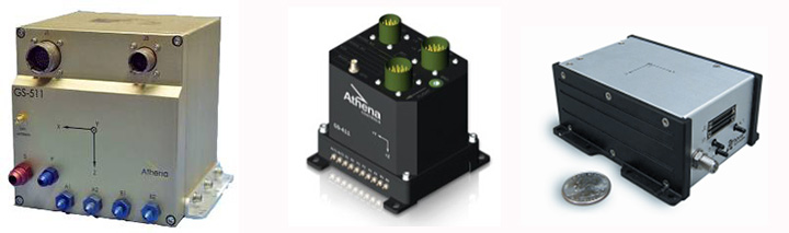
Gladiator Technologies, based in Snoqualmie near Seattle, Washington, is one of several companies currently supplying MEMS-based inertial/gyro systems for a wide range of applications. I came across Gladiator at the Association for Unmanned Vehicle Systems International (AUVSI) convention in Washington, D.C., last August and decided to take a closer look at them as a typical supplier of new, compact, cost-effective MEMS navigation devices, which are becoming essential compliments to GNSS.
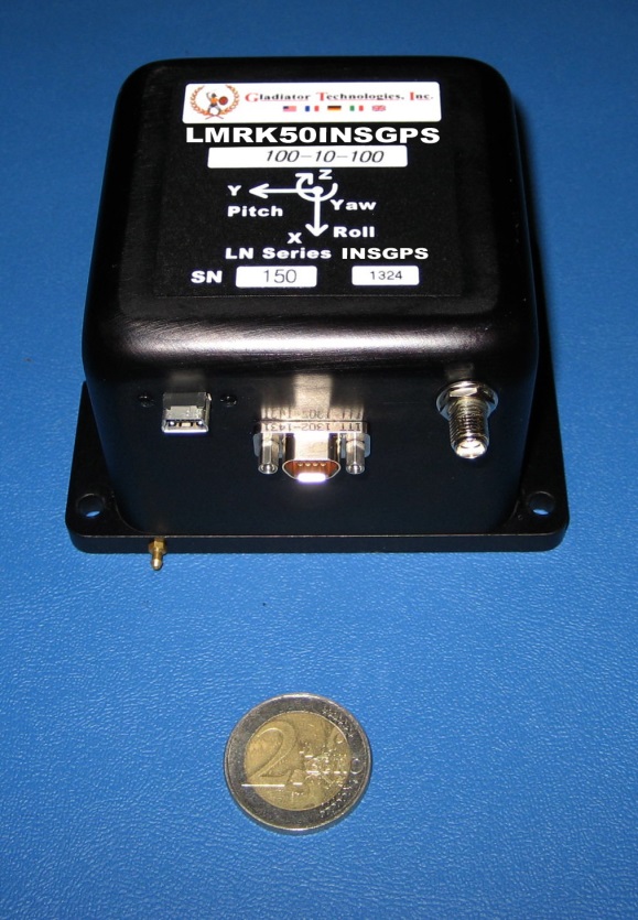
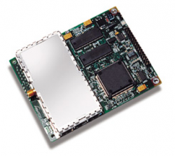
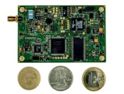
Gladiator has been around since 2005 and has continued to innovate each year, growing its product line and gradually improving performance. Right or wrong, as an “inertial layman” I’ve always used drift rates (bias) to assess inertial accuracy, and this is apparently directly related to the noise floor of the sensor device. Now Gladiator has released its latest Landmark 50 INS/GPS with low noise MEMS gyros and accelerometers and it claims 1 degree/hour drift rate in-run — as good as an 8-cm path length ring-laser gyro — something of an achievement for a MEMS-based device. (That’s a 2 Euro coin used in the photo for size reference.)
Landmark 50 INS/GPS, shown with a 2 Euro coin.
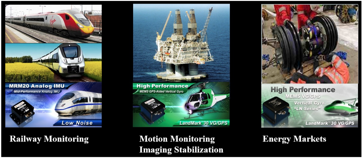
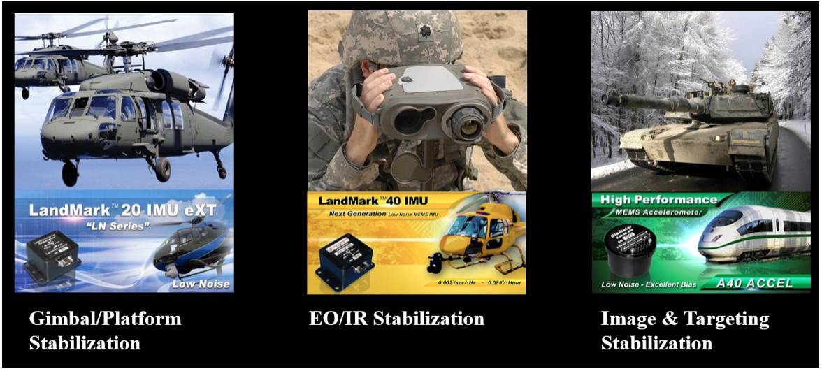
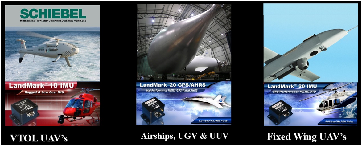
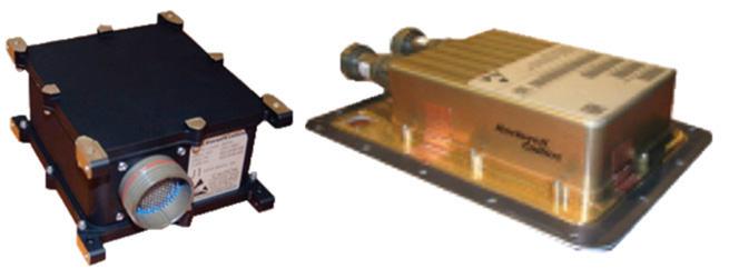
The product line goes all the way from automotive gyros up to the latest high-performance GPS/INS, and includes basic angular rate sensors and accelerometer packages. Applications include automotive testing, agricultural motion sensing, motorsport racing, instrumentation (including robotics and flight testing), rail, marine and energy motion detection, military land-vehicle and marine platform stabilization and navigation, electro-optical/infra-red targeting and stabilization, launcher and missile stabilization/navigation, and unmanned vehicles.
Gladiator integrates u-blox GPS receivers in its GPS/INS systems because of good environmental and test performance and good accuracy and navigation update rates. It’s possible in the future that airborne-qualified GPS or higher performance DGPS will find their way into new inertial variants, but for now Gladiator is very satisfied with u-blox receivers.
Applications may use a single/dual axis gyro or inertial measurement unit (IMU) where angular attitude outputs are required, such as image, attitude or weapons stabilization, or even packaged accelerometers.
And, of course, unmanned aerial vehicles (UAVs) are one of the target markets for these MEMS products — Gladiator has already had a lot of success in this segment. Its equipment is used on a number of unmanned vehicles, including fixed-wing and vertical take-off and landing (VTOL) vehicles, as well as ground and underwater unmanned vehicles. These applications range from primary navigation/backup navigation to primary flight control/backup flight control, and include a large number of stabilization applications including electro-optical/infrared, LIDAR (light detection and ranging) and platform stabilization. Gladiator supplies these UAV applications with various inertial sensors (gyros) and inertial systems, including IMUs, vertical gyros (VGs), attitude heading reference systems (AHRS) and GPS-aided inertial systems. Customers in this market segment include Schiebel, U.S. Army, U.S. Naval Research Laboratory, ST Aerospace, and others.
Gladiator is closely monitoring progress towards UAVs gaining certified access to civil aerospace, and the prospect of expanding civilian applications and markets that that will bring. The company feels that its skills are in and around inertial sensor technology and products, and its efforts towards civil qualification should focus on these elements. Therefore, Gladiator is are looking for a partner who would take on GNSS civil qualification for civil airborne GNSS/INS applications.
Gladiator is still a small outfit with around 30 people, with most of its engineering done in-house by a team of nine engineering staff supported by some external consultants. Senior management has more than 100 years’ experience in this field, and Rand Hulsing, the chief scientist, holds 68 patents in MEMS inertial sensors. New patents are currently pending on inertial-grade gyro and accelerometer designs. People on staff have gained significant experience working for companies such as Allied Signal, Sundstrand, Honeywell, L3, Systron Donner and Hughes.
I pressed Mark Chamberlain, Gladiator CEO, for details of which (bought out) OEM MEMS devices his company integrates into its systems, and I was quite surprised by his response — Gladiator designs its own high-performance MEMS gyros and accelerometers and uses a fabless model to produce them. Clearly, it is having great success with this approach as its product performance has improved to almost within reach of existing technology high-performance inertial systems. Some of Gladiator’s lower end systems do still use OEM MEMS sensors. Their manufacturing facility in Washington focuses on product assembly and test, including calibration and environmental test.
The systems Gladiator supplies are non-ITAR — which is short for saying that they can be exported to most friendly countries, and are not subject to special/restricted U.S. State-Department trade regulations.
Gladiator does around $10 million/year currently, and anticipate its growth to continue. It has a number of sales representatives in North America, South America, Europe, Asia and Australia, so it is well known around the world, with more than 200 customers in 30 countries. I asked Mark about the possibility of an Initial Public Offering (IPO), but he is currently quite happy with the existing private ownership for the time being. The Gladiator board includes investor-directors from France and Germany, and the external directors also have impressive experience, so presumably board guidance has also helped Gladiator get where it is today.
So, we have almost-inertial high-performance products with integrated GPS, attitude-only products and accelerometer packages for almost any application you could imagine, and are quietly inching towards 1 deg/hour total within the next few years — MEMS devices really have come a long way in the last few years.
My original review of the first Yuma rugged tablet from Trimble MCS (Mobile Computing Solutions) was penned in August of 2011. My original plan was to have the review of the new Yuma 2 ready to go exactly two years later. But, as we all know, man plans and God laughs.
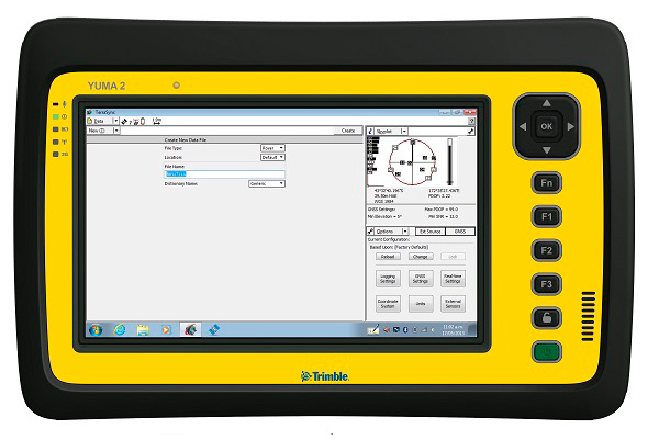
Actually, the problem, I must admit, is a bit more personal in nature; you see, I have been enjoying the Yuma 2 to such a degree that it was difficult to write about it because then I have to send it back. I have been selfish too long — read on for the review of the new Trimble Yuma 2 rugged tablet computer that is perfect for fieldwork, especially fieldwork involving GPS and GIS applications. Indeed, one Trimble marketing quote states:
“Bring Your Office to the Field for Efficient GPS/ GIS Data Management — The Trimble Yuma 2 rugged tablet computer is designed for ease of use and high performance mobility. Great for GIS applications — it’s like bringing a complete PC out into the field.”
While I totally agree with this assessment, the Yuma 2 is really so much more. It is not limited in any important function I could determine. As an example, I am typing part of this review on the Yuma 2 via a wireless Bluetooth keyboard and a high-definition Sony monitor hooked to the Yuma 2 via the new HDMI connector. Sweet!
Over the years, it has frequently occurred to me that oftentimes manufacturers have no idea of all the ways their equipment will be utilized in the field — although Trimble does a great job giving users ideas through the Trimble Dimensions showcase that will take place at the Mirage Hotel in Las Vegas November 3-5, 2014. If you are into rugged devices, GIS and GPS, or any of the areas listed at the Trimble Dimensions website, don’t miss this show. You will see the Yuma 2 and other Trimble devices and software put to the test and used in ways you could never imagine.
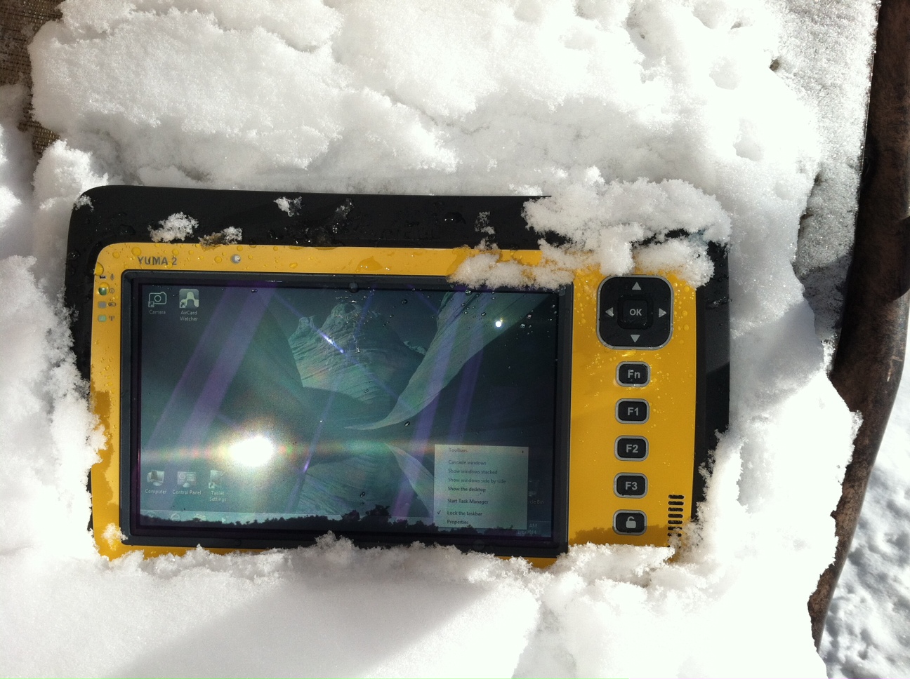
But, as usual, I digress. Let’s get back on topic and the Yuma 2 review. I put the Yuma 2 through all the normal wear-and-tear scenarios, which here in the foothills of the Rocky Mountains means severe cold (-20° F true temperature), snow, ice and altitude.
The Yuma 2 withstands tough conditions, including snow and ice.
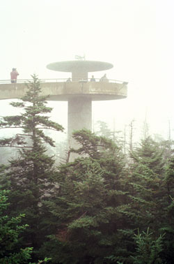
During the six months I tested and evaluated the Yuma 2, I continued to receive several emails from users of the original Yuma rugged tablet. Three of those emails came from users in the Great Smoky Mountains. All three users operate the original Yuma in their business dealings, as well as for navigating around the Great Smoky Mountains and for recreational geocaching. One user, who would only agree to be identified as “Bailey” (he assured me that although he is retired military, his first name is not Beetle), intrigued me with his assertion that he has a crucial usability test he routinely performs on his GPS devices that I cannot easily conduct here in the Rocky Mountains. Beetle and other members of the Great Smoky Mountain Geocaching Society usually perform their Great Smoky Mountain Humidity and Fog tests at or around Clingmans Dome.
Clingmans Dome in the Great Smoky Mountains.
The National Park Service describes the 6,643-foot Clingmans Dome as being the highest point in Great Smoky Mountains National Park. It is the highest point in Tennessee, and the third highest mountain east of the Mississippi. Only Mt. Mitchell (6,684 feet) and Mt. Craig (6,647 feet) — both located in Mt. Mitchell State Park in western North Carolina — rise higher. Additionally, the cool, wet conditions at the summit of Clingmans Dome make the spruce-fir forest that grows there a coniferous rainforest. By now, you are probably saying, so what?
The “so what” is that Bailey says the humidity is sometimes so high that when geocachers hit the cooler temperatures and high humidity of Clingmans Dome, some devices have water streaming from inside the device, which is never a good thing. I checked with Trimble, and indeed their devices are made to survive these conditions and much worse, such as in many mountain jungles around the world. So Bailey, have no fear, your Yuma 2 will continue to work just fine in your moist environment. Consider that the Yuma 2 was designed and built at Trimble’s MCS facility in Corvallis, Oregon, which is just due East of a rainforest along Highway 1 on the Oregon West Coast. So you can bet the Yuma 2 is tested and rated for high humidity levels. Indeed, here are the humidity specifications: Cycles between -22° F to 144° F (-30° C to +60° C) at 90% RH (relative humidity), MIL-STD-810G, Method 507.5, Procedure II (Humidity Aggravated Cycle).
While we are detailing specs, let’s list all the formal specifications, and then we can delve into more detail about how we tested the Yuma 2 and how well it performed.
Physical
Size: (LxWxH) 9.6 in x 6.3 in x 1.5 in (246 mm x 160 mm x 40 mm)
Weight: 2.6 lb (1.2 kg) with standard batteries or 3.0 lb (1.4 kg) with extended batteries
Colors: Yellow, Gray, and Gray with Yellow border
Keys: Seven keys (OK, Logon, Power, Function, 3 user-programmable function keys) and 5-way directional keypad
Hardware Specifications
Processor: 1.6 GHz Intel Atom N2600 dual-core processor
Memory: 4 GB DDR3 DRAM of volatile memory
Storage: 64 GB or 128 GB SSD-Solid State Drive (Enhanced GPS: 128 GB SSD only)
Display: 7” 1024 x 600 hybrid reflective transmissive (transflective) with capacitive touch screen
Battery Options: Smart batteries with LED power indicators – Standard battery: Two 7.5v, 3000 mAh, 21.6 Wh or optional extended battery: Two 7.5v, 6000 mAh, 43.2 Wh
I/O: 3.5 mm audio jack, USB Host (2), HDMI, docking station I/O plate, DC input power
GPS Receiver: 1-2 meter accuracy (with SBAS) or 2-4 meter accuracy (with SBAS)
Radios: Bluetooth 4.0; Wi-Fi b/g/n
WWAN: Penta-band GSM 3.75 Data only module
Standard Features
• Transflective technology (TFT) direct sunlight readable color display
• Microsoft Windows 7 Professional OS
• Intel Atom N2600 dual-core 1.6 GHz processor
• 4 GB DDR3 DRAM volatile memory
• 64 or 128 GB solid-state drive
• Multi-touch capacitive touchscreen
• Rugged design certified to IP65 and MIL-STD-810G
• 3.5 mm audio jack and integrated microphone and speaker
• Outward facing autofocus 5 MP camera with LED Flash, photo and video recording capable
• Integrated Bluetooth 4.0
• Integrated Wi-Fi b/g/n and Wi-Fi Alliance Certified
• CCX (Version 4)
• GPS receiver, Enhanced 1-2 meter accuracy or 2 – 4 meter accuracy with SBAS
• Kensington security slot
• Accelerometer and Electronic Compass
• 3.75 G WWAN data connectivity optional
• Status LEDs for power, battery charging, Wi-Fi and 3G Data
• 12-month manufacturer warranty
Standard Software
• Microsoft Windows 7 Professional with Internet Explorer
• Camera software with geo-tagging
• Trimble GPS Information receiver control software
Standard Accessories
• Standard battery set (5+ hour)
• International AC Charging Kit with 4 adapters
• Capacitive Stylus with Tether
• Hand Strap and Display Cleaning Microfiber Cloth
Now that you have all the specifications and promises from Trimble, let’s look at how it compares to the original Yuma and then let’s get into how it works in everyday life as well as the not-so-routine scenarios.
Comparative Summary of Yuma and Yuma 2 Attribute
Yuma
Yuma 2
Touchscreen
Resistive dual touch
Capacitive multi-touch
Display Technology Sunlight Readability
Very Good
Excellent
Processor
1.6 GHz single core
1.6 GHz dual core
RAM
1 GB
4 GB
Solid State Drive
32 GB then 80 GB
Choice of 64 GB or 128 GB
GPS Accuracy
4 – 6 meter
2 – 4 meter
Battery Life3
4 hours with standard batteries8 hours with extended batteries
8 hours with standard batteries16 hours with extended batteries
Digital Connectivity
ExpressCard Modules
3.75G dual-mode (CDMA and GSM) option with SIM Card and Auto Carrier Recognition.
IP Rating
IP67
IP65
Pricing
$3999 Market Price for base configuration
$2999 Market Price for base configuration
First Impressions
The first thing most people notice about the Yuma 2 is its size. It is 1.5 inches shorter than a full-size iPad, while the high-definition screen is the same size and almost the same resolution as the iPad mini. With the ingenuous hand-strap attached to the back, the Yuma 2 is very maneuverable and easy to carry with you in most any situation. With the security cable, you can also attach it to a vest, backpack or even a belt loop for security. I tried all three options and it works well. For warfighters and first responders, this is ideal, as those users don’t need to worry about what happens if they should drop it. The Yuma 2 is IP65 MilSpec rugged, and I am frankly amazed at the punishment my demo unit survived. Just like the old Timex commercial — “It takes a licking and keeps on ticking.”
Attention Getter
I carried the Yuma 2 everywhere for more than six months, and it garnered a great deal of attention from military and medical personnel of all descriptions: policemen, firefighters, delivery drivers, utility workers, and several park rangers. Even our local refuse haulers spent time looking over the Yuma 2. It is just simply hard to ignore. Interestingly, something they all had in common is that initially they were all very dubious and nervous about dropping it, even on thick carpet, grass, ice or snow. But once they saw me do it, they all wanted to have a go and they did. My demo unit has easily been dropped more than 100 times from various heights, usually from about four feet onto almost any surface you can name, and it continues to perform like the pro-gear it is and was designed to be. It was even dropped twice, unintentionally of course, with the camera in video mode and the LED flash active. I have to admit that initially gave me pause, but the Yuma 2 came through without a hitch. Camera, video and flash all still function perfectly.
Field Capability and New Test
With the Yuma 2, I had an opportunity to test an application I have never run before, but which will now be a standard in my repertoire of applications — the functionality of an audio headset along with Dragon Speaking software.
Long story short, my daughter is a PsyD, or Doctor of Psychology, in private practice, and together we have been testing various software programs that convert her spoken notes into the written word. This is a more difficult task than you might imagine, given all the specialized medical and psychological terms employed in her everyday vocabulary. But the latest professional version of Dragon Speaking was absolutely up to the task, as was the Yuma 2. I installed the Dragon software and went through the brief training routine with the headset and microphone, and the result is the paragraph you are reading. What a great way to write an article.
Now my daughter and I are Apple aficionados. We have more than 21 Apple devices in our homes, and my daughter uses a 13-inch Apple MacBook Pro with a retina display in the office, which, while it is an awesome device, is not something you want to take into the field or into a first-responder situation, whereas the Yuma 2 fulfills the same functions and fits the “rugged” bill perfectly.
While the built-in speaker on the Yuma 2 is certainly adequate for voice recognition and for GPS commands, it is not something with which you will want to listen to iTunes, so I highly recommend the optional audio headset with microphone offered by Trimble and several other suppliers. For me, the new Bose headset model with microphone works extremely well, while remaining affordable, and the resulting fidelity is…well…certainly Bose quality — what more can I say!?f you want audiophile-quality music and speech-to-text transcription capability in the field, then the Bose headset and Yuma 2 combination can’t be beat.
Docking Station and HP ePrint
The unit we tested did not arrive with the optional docking station. However, we quickly determined that if you are going to be constantly, even daily, making the transition from field to office computer and want to work on the same computer, then a docking station is a must. Next time, say for the Yuma 3 review, for instance, we will request a docking station as part of the review hardware. There were so many times we wanted to print directly from the Yuma 2 that I wished fervently for a docking station. Then I found that the HP ePrint software worked just great on the Yuma 2 as long as you are in range of a printer capable of receiving the signal.
If you are on the road and need to print, you can do that via the cloud and ePrint no matter where you are. You can also print your documents to the nearest HP Public Print Locations, which include national chain locations for FedEx Office stores, UPS stores, Walgreens, numerous hotels, airport lounges, and more. Prices vary widely per page, but if you really need a hard copy, this is an amazing option that works well with the Yuma 2.
We tested this print option at our local Walgreens, and they were not initially aware they had the capability until we printed a test page and out it popped. Now they advertise the capability. We also tried printing from the parking lot of a local FedEx store, and since I have a FedEx account (we receive a lot of packages, as you can imagine), the page was waiting for us when we walked in the door and the bill was automatically charged to our FedEx account. It was an incredibly quick and painless process.
Camera and Flash
The 5 MP (megapixel) camera with automatic geotagging and LED flash work as advertised, although with the Yuma 2 we were also able to record a short video that played back flawlessly on the Yuma 2 and via the email attachment on my Apple iMac. The only caution here is that you are definitely capable of recording a video that, due to its size, may never work its way through the normal email system. Fortunately, the GPS World magazine servers and my “other office” servers are “unlimited,” so this was not a problem for us. However, when we attempted to send a 20-MB video file to a friend, his system would not initially authorize it. When we compressed the file, it went without a hitch. So, if you are going to be shooting a lot of video in the field, a good video software compression program is highly recommended. We tried no less than five different free video compression algorithms, and they all worked without a glitch. Note: Some programs, but not all, require the same software be resident on the receiving computer as well.
Power and Data Connectors
Fortunately, the power connector on the Yuma 2 device is heavy duty. It is reminiscent of the old serial port (RS232C) connectors with the screw receptacles on the port. Consequently, you will never have to worry about the power cables being disconnected, at least not on the Yuma 2 side. There is also an USB-RS232C dongle available that comes in handy for data logging from external sensors.
GPS Applications and Accuracy
While Trimble MSC is not publishing much about the GPS specifics, from a technical point of view in the Yuma 2, Trimbe is shouting from the rooftops that you can have nominal 2-4 meter accuracy or enhanced 1-2 meter accuracy (both with SBAS or Space Based Augmentation System – in the U.S., think WAAS or Wide Area Augmentation System) depending on your requirements. There is an option for an external GPS antenna, and while the three different RTK programs we ran on the Yuma 2 produced excellent and consistent sub-meter accuracies, RTK programs can be expensive. So with the Yuma 2 you should be capable of deriving accuracies anywhere from 4 meters to 4 cm, depending on your timing requirements, how much you want to spend, and sometimes your altitude.
Altitude
Which reminds me: I really got a kick out of the correspondence from the three geocaching Trimble Yuma users in the Great Smoky Mountains, mentioned at the beginning of this column, because all three made such a big fuss about the 6,000+ feet of altitude they routinely encounter when geocaching. My initial reaction to that concern is akin to that of the old codger mountain man in the great movie Continental Divide with John Belushi and Blair Brown in 1981.
John’s city-bred character mentions that being a smoker the high altitude in the Rocky Mountains is beginning to bother him, at which point the heretofore reticent old mountain man indignantly replies, “Mountains? These here are foothills, just bumps in the ground, these ain’t mountains!” Therefore, since my home sits at an altitude 1,000 feet or more higher than any of the Great Smoky Mountain peaks, and I can be at 14,000+ feet within a 20-minute drive and cross the Continental Divide in under an hour’s driving time, I understand the old mountain man’s consternation and directly relate it to the users’ concerns about the Great Smoky Mountains, which when compared to the Rocky Mountains in Colorado, are indeed bumps in the ground. I mention this only because at 7,500 feet with no obstructions, the Yuma 2 routinely processes 8-12 GPS satellites and reports accuracies far superior to those publicized by Trimble. So, while you should not necessarily expect the same level of accuracy I have reported here, you should probably expect accuracies in between what Trimble publicizes and the sub-meter performance we observe on a regular basis.
Software
I have frankly lost count of the multiple GIS and GPS software programs I ran on the Yuma 2, but they all basically ran flawlessly, both the free apps and the more costly programs. The only issue I encountered is that some GPS programs require utilizing different ports and transmission speeds. However, since these parameters are user definable on the Yuma 2, it never presented any serious obstacles. Caveat emptor, for here I will remind users of the old axiom, “You get what you pay for!” The free GPS and GIS apps work fine, but the amount of metadata and accuracy provided by some of the more costly applications is nothing short of amazing. If you plan to use the Yuma 2 for scientific applications and desire onboard processing, then the more costly software programs are the applications I would recommend. If the Yuma 2 is just a data logger or positioning device, then the free applications work well.
Bottom Line
The Yuma 2 is an amazing machine. It is everything a high-end laptop should be and more in a ruggedized format with a Gorilla Glass high-definition display touchscreen that should be reassuring to users in the field.
For government users, the rugged Yuma 2 tablet with a Selective Availability Anti-Spoofing Module or SAASM option would be the perfect choice, and far superior to anything else in the field today, especially for our military. My sources tell me there are thousands of Yuma and Yuma 2 tablets in the field today, and the addition of a SAASM module would make them more secure and usable by our military users for all their tasks. Imagine one secure tablet that meets all your needs. I think our warfighters deserve the best, don’t you?
If you currently accomplish fieldwork and transfer data between two computers, and make use of GIS and GPS data, then the Yuma 2 is the machine of choice for you because it will do the work of both computers and display/output data through the HDMI interface or through the wireless ePrint capability, especially if you opt for the optional docking station. The SSD (solid state drives) are super fast, and since there are no moving parts on the Yuma 2, you may well find it is faster and more dependable than your current office laptop or even desktop computer. I highly recommend it.
Until next time, happy navigating and take a rugged computer out for a spin.
First of all, let me wish a Happy New Year to all my friends around the world and a prosperous 2014. I’m as excited as I’ve ever been about GNSS technology.
If I may ask for forgiveness from you if you live outside of the United States, I’d like to start out answering a question I’ve been asked about for several years. The question is:
Do you have a list of free sources of RTK base station data in the United States?
What is RTK? In a nutshell, RTK is 1-2cm real-time positioning. Some refer to it as “survey-grade”. Historically, RTK users have been required to setup and maintain their own RTK base station. This is expensive and inconvenient. Many federal, state and local government agencies have setup RTK bases to increase RTK efficiency for their employees. Many of them make the RTK base data available to the public for free or for a nominal cost. If you work in an area that offers one, all you need is internet access in the field and a RTK-capable GPS L1/L2 receiver.
I’ve tried to keep track of the public RTK bases I know of, so I’ll list them here. If I’ve missed one you know of, please feel free to send me a quick email at [email protected] or list it in the Comments section at the end of this article. Furthermore, if you live outside of the U.S., I’d love to hear from you if you know of a source of free RTK base data.
Please note that in the following list there are four types of RTK bases:
I’ve used an RTK rover on all three of these services. Each of them has several mount points supporting different data formats. I typically use RTCM3 format because it’s an open standard and supported by all services I’ve used. For the Leica Spider network, you’ll be presented a choice of iMAX or MAX. Choose iMAX if you’re not running a Leica rover.
To use any of the services, you’ll need Internet connectivity. In the past, I’ve accomplished this in a few ways:
SIM card inside a data collector.
MiFi device.
Wi-Fi from a work vehicle.
You can also use a commercial RTK Bridge or Repeater such as Intuicom or Base-n-ABox. Or you can create your own RTK bridge system with a notebook computer that has internet access.
No matter how you do it, you’ll need a reliable Internet connection (speed is not important).
You’ll also need some sort of NTRIP software utility. Several data collector software packages have this built-in. For software like ArcPad, DigiTerra, gvSIG, etc. that don’t have it built-in, there are some freeware utilities on the market that run on Windows and Windows Mobile and Android (for example, SXRTN or Lefebure) that handle the NTRIP tasks in the background.
Following is a list of RTK bases in each U.S. state, along with the associated website. Please note that I only list the public (government-operated) services. Also note that while most are free, some of the public operators charge a user fee. At one point or another, I’ve used a fair number of these in various states. Once you’ve used one of each (Trimble, Leica, PBO), the rest are pretty much the same.
The difference between the Trimble and Leica networks and PBO is that the Trimble and Leica networks provide a network solution that utilizes several RTK base stations in the computation. Distance-dependent errors are reasonably modeled so the user can be farther from individual RTK bases. The PBO RTK bases provide a single baseline (like everyone used to use before RTK networks were invented) so the further you are from the RTK base, the more error is introduced into the solution (roughly 1 cm + 1 ppm).
Lastly, there are a number of commercial RTK networks in most of the states listed. I’ll save that list for another day. Again, these are just the publicly run RTK bases.
Highly precise and free for use by anyone with an inexpensive receiver, GPS and other GNSS are great. Their navigation and timing signals have been incorporated into nearly every aspect of modern life, from synchronizing power grids to financial systems, the Internet, telecommunications, and transportation. The U.S. Department of Homeland Security estimates that these signals are used by all 16 of U.S. critical national infrastructure sectors, and are essential to the functioning of 11.
Jamming Threat Growing. When these faint signals can’t be received, people start to feel the impact immediately. Usually outages have minimal impact because they are localized and short-lived. Often they occur because the user is temporarily in an area without a good view of the sky. More and more often, though, they are due to the presence of one of a growing number of people with jamming devices (many of which also block cell phone frequencies).
Inexpensive, easy to obtain, and illegal, jammers are spreading as people become more concerned about privacy and being tracked by their employer, spouse, the National Security Agency, and others. Although the government tries to collect information on jamming incidents, no widespread detection system has been established, and few verbal reports are received. For the calls that do come in, it is often impossible to determine which are because of user error and which are purposeful interference.
For those cases where jamming is discovered, locating and identifying the perpetrator is difficult and often impossible. As one example, in spite of near-daily disruption of GPS that caused the shutdown of a new landing system at Newark International Airport, it took the Federal Aviation Administration and the Federal Communications Commission more than two years of concerted effort to identify the single perpetrator.
If a navigation satellite outage became widespread and lasted more than a few hours because of a major solar flare, software problem, hacker or cyber-attack, most authorities agree that the impacts would be catastrophic. While much of the information is classified, we do know that transportation would immediately become much less efficient and more dangerous; even many traffic lights are coordinated using satellite timing. Telecommunications, financial, energy and other systems would soon begin to fail as their back-up timing systems lost synchronization with each other. Power grids would lose synchronizations and outages may occur as transmission points became overloaded.
More than speculation, these problems have been documented in academic papers, proven in government tests in the United States and the United Kingdom, and the early stages of such impacts have been observed in localized and short-term outages in the United States. Most dramatically, they have been demonstrated by North Korea’s intentional jamming of South Korea.
Spoofing. Of equal concern is the problem of spoofing. The world’s preeminent ethical spoofer of satellite navigation receivers, Todd Humphreys of the University of Texas, Austin, has demonstrated how easy it is to take control of unmanned aircraft and ships on autopilot by sending a slightly stronger navigation signal, making the receiver think it is somewhere other than where it is. Iran claims to have done something similar, capturing a U.S. military drone in 2010. Humphreys has also shown (on paper) how time-stamps on automated financial transactions could be altered through spoofing. This could do things like reverse the buy-sell equation at a stock exchange, allowing someone to sell at a higher price before buying at a lower one.
The Government Solution
What is to be done? The challenges have been extensively documented and discussed since at least the 1990s. In 2004, President Bush issued the National Space Policy (NSPD-39) that addressed the problem. Although portions of it are still classified, contained within the publically releasable section was direction for the U.S. Department of Transportation (DOT) to, in coordination with the Department Homeland Security (DHS): “develop, acquire, operate, and maintain backup position, navigation, and timing capabilities that can support critical transportation, homeland security, and other critical civil and commercial infrastructure applications within the United States, in the event of a disruption of … space-based positioning, navigation, and timing services.”
eLoran Recommended. In response, the two departments consulted numerous experts and commissioned a study by the Institute for Defense Analysis (IDA) to determine what system or systems should be procured. The IDA study team, which included Brad Parkinson, widely recognized as the father of GPS, unanimously recommended that an existing and outdated nation-wide navigation system called Loran-C be greatly updated and modernized to eLoran. Such a system would provide a navigation and timing signal comparable with and complementary to GPS. They concluded that:
“eLoran is the only cost-effective backup for national needs; it is completely interoperable with and independent of GPS, with different propagation and failure mechanisms, plus significantly superior robustness to radio frequency interference and jamming. It is a seamless backup, and its use will deter threats to US national and economic security by disrupting (jamming) GPS reception.”
What the IDA did not find, but that has since become evident, is that establishing an eLoran system could be an important part of a network to identify and locate jamming attempts. Since all eLoran transmitters would be synchronized with GPS, and many navigation receivers would have both GPS and eLoran sensors, differences between the two systems could be immediately detected and reported.
The body in charge of coordinating navigation and timing issues for the federal government is the National Space-Based Position Navigation and Timing Executive Committee (NPEC). It is chaired by the Deputy Secretaries of Transportation and Defense. Responding to early briefings on the IDA report (which was not formally published until 2009), the Departments of Transportation and Homeland Security in 2007 told the NPEC that they had decided eLoran was the right answer. After further federal deliberations over how to create an eLoran system, 2008 saw:
A press release by DHS saying that the department would implement eLoran, using the old Loran-C infrastructure (February 7, 2008)
The DHS 2009 Budget in Brief (February 2008) propose transferring legacy Loran-C systems and $34.5 million/year from Coast Guard to the National Protection & Programs Directorate (NPPD) within DHS, stating:
“The FY 2009 budget transfers the budget authority for the LORAN C system from the United Sates Coast Guard to the NPPD. The Department, acting as Executive Agent, will begin development of enhanced eLORAN as a backup for GPS in the homeland.”
The National PNT Executive Committee endorse the above decisions (March 2008).
Failure to Launch
Unfortunately, DHS funding for 2009 came as part of a continuing resolution, and the Congress did not see fit to approve the transfer of funds from Coast Guard to NPPD.
This was because influential members of Congress wanted the nation to have eLoran, but were concerned about the lack of a plan for transition of this important capability from one agency to another. The administration was asked to develop and submit a plan with with the next budget cycle. A year later, though, no plan had been presented, and the President’s request (and enacted legislation) for 2010 contained no request to move and upgrade the system. In fact, it contained provisions for shutting down and defunding the old Loran-C system without providing funds for NPPD or any other agency to establish the new eLoran capability.
No Solution at All. What happened between one budget year and the next to take the nation from “solution-in-hand” to “no solution at all” is not a matter of public record. Internal administration budget deliberations are not generally released to the public. It does appear, though, that a new administration putting together its first real budget quite rightly wanted to shut down an antiquated system, but did not understand the importance of a new one. This, and many other factors, unquestionably played a role.
Movement Backward
Without any funding, DHS has since conducted several studies and experiments, but has done very little of substance to address this critical infrastructure issue. While Department of Defense (DOD) officials talk about the need for resilience, experts throughout government and industry decry the lack of action, and the Department of Transportation still has acquiring “backup position, navigation, and timing capabilities” on its to-do list, none have seen fit to move forward on their own.
Felling Towers. Worse, DHS is actually reducing the nation’s ability to create eLoran and a wide-area interference detection and mitigation system. An ongoing effort to fell towers and dispose of equipment from the legacy Loran-C system will significantly increase the cost and time-to-operation of the new system the nation needs.
The Way Forward
Fortunately, awareness and understanding of the problem within government, and the general public has continued to grow.
The U.S. National Space-Based Positioning, Navigation, and Timing (PNT) Advisory Board published a seminal white paper in 2010 on the topic, strongly recommending the establishment of an eLoran system. Todd Humphreys, the UK navigation authority, and others have provided numerous graphic demonstrations of the folly of relying upon just one electronic navigation system, and how things can go horribly wrong. Some of these have been well publicized. Other incidents are known only to a few.
There are also signs that the U.S. intelligence, cyber, and defense communities are becoming more and more concerned. North Korea’s repeated jamming of satellite navigation and timing signals has delivered a particularly powerful lesson. South Korea has reacted by committing to establishment of a robust eLoran system. The UK has established an eLoran system and is expanding it. Russia and China have retained their versions of Loran-C and are using it to augment satellite services. Russia has announced it will upgrade its system to eLoran in cooperation with the UK, and China may not be far behind. Saudi Arabia is upgrading its system to eLoran, and India has plans for an eLoran network in the near future. In December, Iran announced it has established a land-based system with “powerful transmitters” that is “completely different with GPS.”
Allies, adversaries, and economic competitors are augmenting satellite services with strong terrestrial ones. The United States will soon be one of only a small number of major economies that does not have a strong, difficult-to-disrupt terrestrial system protecting its critical infrastructure and providing value-added utilities. DOD’s chief information officer expressed interest in eLoran as part of DOD’s pivot to the Pacific. But providing a system at home is not in Defense’s job description, nor should it be.
Respected leaders at the Departments of Transportation and Homeland Security still see this as an important issue that needs to be addressed. The question for them now is not one of technology. The technology decision made in 2008 has since been revalidated by a plethora of academic papers, risk estimates, and white papers. eLoran still appears to be the most effective and least expensive solution available. DOT and DHS must resolve questions of governance and how to fund the system in one of the most difficult federal budgetary climates in decades.
How? The answer could lie in a public-private partnership (P3). In such an arrangement, the government would bring its interests and the infrastructure it owns to the table. An entity in the non-profit sector or industry would provide investment to refurbish the infrastructure, stand up, and operate the system. Such a P3 enterprise could not only pay for itself, but be an on-going source of revenue for both the government and the private entity.
The Business Model: Demand
A well-configured eLoran system can provide navigation accuracy to within 8 to 10 meters and timing accuracy to within 30 nanoseconds. This meets the needs of an estimated 95 percent of users in the United States. While eLoran does not offer the sub-meter precision of a high end, augmented GPS/GNSS system, it has its own advantages. In addition to being very difficult to disrupt, its high-power (typically 400 kW transmitters), low-frequency (100 kHz) signal easily penetrates and is usable underground, inside buildings, and underwater — where satellite and cell phone signals on much higher frequencies cannot reach.
The UK experience with eLoran and private surveys in the United States have shown high commercial demand for a ubiquitous, wireless, precise, and resilient time and navigation service. Power companies want to synchronize grids with a signal that can’t be disrupted by a delivery driver trying to avoid being tracked by his boss. Cell phone companies would be happy to have alternative timing capability in their networks, provided through inexpensive eLoran receivers. Operators of autonomous vehicles want a robust navigation signal and guaranteed communications. And it would be welcomed by the many users who, research shows, rely upon GPS/GNSS time for mission-critical applications, and who have no secondary source on which to fall back in the event of a disruption.
Since eLoran easily penetrates inside buildings, underground, and underwater, it can be used for timing and navigation in many places where no other navigation and timing sources are available. For example, it has been used for underground and underwater navigation. When paired with an accurate satellite signal before going underground or submerging, eLoran could enable a navigation receiver to maintain a comparable level of precision for several hours. Even after that, it would provide the navigator an accurate underground/underwater compass, and a good position.
The eLoran navigation and timing system now in operation in the United Kingdom also generates revenue by transmitting data. While the full potential of this third-party data-channel capability is still being explored, the ability to assure data delivery to, and communicate with such areas is appealing to many commercial and government organizations. Potential first-responders and commercial benefits appear almost limitless.
The Business Model: Costs
The cost for the P3 to standup and operate an eLoran system in the United States would be exceptionally low. Most of the needed infrastructure is already owned by the federal government in the form of the sites for the shuttered Loran-C system. Many of these still have transmission towers and other equipment that could be repurposed. Re-using this infrastructure and equipment would greatly reduce both the time and expense needed, compared to standing up the new system from scratch.
Operating and maintenance costs would also be low. Solid-state equipment, remote monitoring, and other advances in technology make the process of re-establishing a transmission site fairly inexpensive. Today’s eLoran transmitting site consists of a tower, an equipment enclosure for the transmitter, a fence, and a backup generator. With only a modest investment to refurbish existing infrastructure, regular outlays to service capital debt would be minimal, at best.
Some estimates predict that a terrestrial precise navigation and timing system, such as the one established in the United Kingdom and the one up for contract by South Korea, could be established in the continental United States within three years and for approximately $40 million, if the existing infrastructure were repurposed. Operating costs are estimated at approximately $16 million per year.
Business Model: Revenues
Significant national and homeland security concerns, high demand, and low cost (especially compared to any government space program) — clearly, but for a series of unfortunate bureaucratic reasons, eLoran would have been established in the United States, probably as a government-owned and operated system, long ago.
But high demand and low cost are also excellent ingredients for a business enterprise, provided there are sources of revenue. An eLoran P3 could have multiple sources of revenue. Depending upon the type of partnership and business model(s) the government selected, surplus revenue could also be generated to help fund other programs or offset the deficit. Some of the possibilities include:
◾ Guaranteed Delivery Data Transmission. As mentioned earlier, eLoran’s high power and low frequency mean that the signal penetrates where few others will. In addition to navigation and timing information, which are inherent in the basic signal, low-rate data can also be included between the primary pulses. The highest demonstrated data transfer rate to date has been 1300 bps, which is fine for texting and issuing commands. Many believe that, with a modicum of research, that rate can be much higher. As the owner of the high-power transmitter network, the P3 would generate revenue the same as any telecommunications provider: by charging per message or for time on the network.
Applications could include:
• Assured wireless control of remote equipment and vehicles, including indoors, underground and underwater;
• Information delivery to first responders and other crews regardless of location — especially good for pre-programmed emergency and operational commands to evacuate, use another procedure, and so on.
• Immediate device updates and reprogramming. The ability to reach all of the enabled devices on a given network at the speed of light and virtually simultaneously has unlimited potential.
◾ PNT Interference Detection and Monitoring. One of the biggest challenges to countering jamming satellite navigation and timing signals is the lack of a detection network. The eLoran transmitter and receiver network will continuously synchronize with GPS/GNSS signals and instantly detect when differences between the two dissimilar systems occur. Instant reports could be generated to inform federal, state, and local authorities of the anomalies and their locations. Mobile disruptors could even be tracked as they drove down the highway, sailed through the port, or flew across the sky. The P3 could generate revenue by contracting to provide such information to private parties and government agencies concerned about interference incidents.
◾ Licensing Receivers. One of the simplest ways to generate revenue and endow the P3 would be for the government to assess a small fee on every eLoran and satellite navigation receiver sold in the United States. A one dollar fee per unit could generate more than $20 million per year and fund operation of the entire system. Such a fee could be discontinued as other sources of revenue from the system made it unnecessary.
◾ Broad-based User Fees. Since navigation and timing signals are essential to so much U.S. critical infrastructure, a case could be made that the cost to endow the P3 should be spread as broadly as possible across the technologies it supports. For example, a temporary 8-cent fee on every monthly U.S. cell phone and electric bill for just one year could provide enough funding to endow the P3 in perpetuity.
◾ Value-Added Services For High-End Users. More than 90 percent of the users of precise time in the United States require it at the microsecond (1,000 nanoseconds) level of accuracy. eLoran can provide a signal accurate to 30 nanoseconds. To achieve that level of precision, the eLoran network transmits data that compensates for low-frequency signal propagation over non-homogenous terrain. This correction data could be encrypted. Most users would access the signal at the microsecond level of accuracy for free. Revenue could be generated by charging those who desire the higher level of precision a fee for the encrypted portion of the signal.
eLoran is an essential national and homeland security capability. The above list of potential revenue sources is just a sampling of the many ways a P3 could be funded. The point is that financing the enterprise need not come from tax dollars, and should not be an obstacle to its creation.
The Public-Private-Partnership
The U.S. government has had some great successes solving previously intractable problems through public-private-partnerships. Probably the best known of these are the P3s formed for housing on military bases. Establishing a business model that has private partners constructing and managing on-base housing produced more and higher quality housing for our troops.
Such arragnements must be carefully managed, however. Both the Congressional Budge Office and the Office of Management and Budget are understandably concerned that P3s may get a project going, but soon the costs may fall entirely on the government.
Success in any endeavor often depends upon its execution. The type of partnership the government selects and creates will be key. While, at its heart, a P3 is just a contract, the nature and provisions of government contracts are endlessly varied. Issues to address will include how the infrastructure is provided, if it is to be retained in perpetuity by the government or will be conveyed to the private party, what length of contract will allow the private partner to recoup its initial investment, and the business model(s) to be pursued.
The type of governance will also be important. Models vary from establishment of a self-funded government corporation to oversee daily operations, to an agency-supervised, performance-based contract that only requires regular reports on system availability and performance.
Of course, the concerns of CBO and OMB must be met. Fortunately, the federal government is not without experience with P3s. Also, there are many supporting resources available, such as the National Council for Public Private Partnerships.
We Have to Do It
Establishing a public-private partnership will bring together the best of both the government and the private sector. For its part, the government will bring the legacy infrastructure and its interest in safeguarding the public good to the table. The private sector will bring financing, technical know-how and innovation. A better system for America will result than would have been possible if either were to act alone.
It is unquestionably in our urgent national interest to address the problem now, before jamming becomes more widespread, or we have a larger, more damaging event. The need is clear. The technology exists and works great. All that remains is for dedicated leaders within government and the private sector to work together and implement the solution.
Dana A. Goward is the president and executive Director of the Resilient Navigation and Timing Foundation, a non-profit organization devoted to educating people about the need for and encouraging resilient navigation and timing ecosystems with services that complement each other and have different failure modes. See www.RNTFnd.org.
Prague is now the headquarters of the European GNSS Agency (GSA).
A holiday card from a colleague in Europe calls to mind GNSS’s headlong course into the future, coupled with that most backward-reflective of human preoccupations, history.
The European GNSS Agency (GSA), whence originated this card, moved from Brussels to Prague in September 2012, in a nod to the pan-European nature of the European Union (EU) generally and its GNSSs, Galileo and EGNOS, in particular. No EU agency headquarters had been sited in Eastern Europe, and it was deemed that some soon must do. Prague made a strong bid for the GSA.
A political, cultural, and economic center of central Europe under its current name since the year 908, it has a settlement history dating back to 1306 BC. Good King Wenceslaus, who looked out upon the snow round about, deep and crisp and even, and about whom we sang festively this past season, ruled from Prague around 935, subsequently rose to sainthood, and is the patron saint of Bohemia, the Czech homeland.
The GSA has a rather variegated mission: it “manages public interests related to European GNSS programmes.” This includes everything from marketing to security — in a sense, everything satnav-related that scientists and engineers do not do. Its list of tasks and responsibilities includes 12 subheads and 61 bulleted points.
Carlo des Dorides, GSA executive director, noted upon opening the new headquarters in 2012 that Prague derives from the Slavic word praga, for threshold. “I think this is appropriate for the GSA and Galileo, as it represents the beginning of a key step for both.” EC vice-president Antonio Tajani added, “Galileo is important not only for space policy and science, but for the services and jobs that it brings.”
Thus the many GSA staffers labor to wring full advantage for modern economies from the space-based radio signal generators, amid the cobblestone streets and ancient monuments of one of the best-preserved ancient European cities, a UNESCO Cultural Heritage site.
While busily plunging into the future, we cannot escape our past.
2013 was an up-and-down roller coaster of a year for the location industry…and 2014 appears to be more of the same. What was the big story? Google buying Waze? While it is easy to predict what will happen, the harder thing to do is to predict when it will happen. With that in mind, LBS Insider reached out to industry veterans to discuss the big buzz in 2013 in the industry — and what the future holds, next year and beyond.
“The valuation remains a mystery to many in the mapping community, but it is always nice to see a truly great exit in this business. There haven’t been enough for an industry that is both foundational in mobile and online, and really hard to do well,” said Marc Prioleau, president of Prioleau Advisors.
Prioleau says one of the big stories of 2013 was the reemergence of Apple Maps. “For all the flak they took, they’ve worked hard to make them better. Their default position in iOS has given them traffic, as has the extension to OSX in the Maverick’s release,” he said. “Last year you saw Apple start to buy companies that could extend the features (like HopStop), a sign that they think they’ve fixed the major problems and are working on moving forward. They are also hiring aggressively and have brought in some very good people.”
Last year, Prioleau predicted that the combination of data with location to derive better location-based context would be a big thing. “I think a lot has happened in that area with much more to come. It’s happening in apps (see Foursquare recommendations), advertising (PlaceIQ and others), CRM (SAP Precision retailing as an example),” he said. “There is a lot more to come here, and we should expect many new applications, most of which will do things badly, but some — likely the ones with the most targeted data — will do things that really change the model.”
Prioleau says MapBox is making mapping cool again (and Prioleau is a director at the company). “Just when all was going to be subsumed by the Google Maps juggernaut, MapBox is doing new interesting data visualization work,” he said.
Crowdsourcing being embraced by the wider mapping community is another big trend Prioleau has identified. “Everyone knows about OSm, but then you add Waze for crowdsourcing real-time traffic plus map corrections. Google is in deep with MapMaker, and even Nokia is pushing crowdsourced input,” he said. “It’s no longer the battle between crowdsourced maps and professional maps. It’s how to make the two work together.”
Prioleau sees the location industry having a few benchmarks in 2014. “I’ll stick with the same prediction as last year: Data + location for better location context. Google Now is a great benchmark,” he said. “Break out in location-based ad targeting. The technology is better, and the providers really understand the advertising market now. Complementary ad technologies like Real Time Bidding are maturing, and these will fit in to a model that really works. And if for no other reason, if we keep predicting it, it will be right one year, right?”
Prioleau believes Google Map domination will begin to show cracks. “Google has a great platform, but as they monetize it more aggressively, more companies will look for alternatives,” he said. “Apple maps will be one. HERE will be another. But solutions from MapBox and others will grow as well.”
In terms of connected car and other automotive technology, Prioleau says new and interesting applications will come from local search, driver services, and diagnostics — rather than just basic navigation.
Another industry insider, Mike Dobson, president of TeleMapis, said 2013 was a quiet year for location-based services. “Even the biggest deal, Google’s acquisition of Waze, does not look as if it will have much impact, other than as a defensive strategy. Perhaps the most interesting aspect of the year was the stream of patents covering LBS and GIS-like applications from both Apple and Google, not to mention those of several start-ups,” he said.
From his perspective, Dobson said 2013 was yet another year in waiting, but 2014 looks like it might actually be exciting. “It appears that Google will finally make its move into the in-car navigation market. Apple is beginning to play with the idea of allowing its users access to a more GIS-like parsing of its map database,” he said. “Perhaps the biggest change will be a new focus on thematic maps that aim not to be navigation aids, but to perform the function of information devices for travelers and others using directed search technology. I suspect that 2014 will be another slow year for indoor positioning, but maybe it will flourish as a subset of BIM.”
Indoor Mapping Still Considered Trend for Location Industry
While many in the location industry have seen new companies and products coming to the indoor positioning market, at least one analyst says that Wi-Fi positioning has been weak.
“The biggest trend in 2013 was indoor mapping, the beginning of the hockey stick adoption curve in my opinion. Major retailers like Home Depot, Lowes, etc., launched indoor maps with product search/locator,” said industry veteran Kris Kolodziej. “What was overblown was indoor Wi-Fi positioning. The latency and accuracy is not good enough for micro location. It’s good enough to know what store/venue you’re in, but that’s about it.”
Kolodziej said that the big deal in 2014 will be ibeacons or Bluetooth low energy (BLE) for micro location and proximity services. “BLE solves the many shortcomings Wi-Fi has,” he said.
Prioleau says that in-door location will be big, but it is where outdoor location was in the early 1990s: many technologies and technology providers all pushing different solutions — and most will not succeed.
“Beyond the location technology, the market needs to figure out how the money will flow from beneficiaries of the market (retailers, brands) to the providers of indoor location technology (mostly semiconductor companies and tech companies). There is no natural connection,” he said.
In recent years, we’ve seen explosive growth in the Unmanned Air Vehicle (UAV) market segment, with most on-board navigation systems relying on GNSS or GNSS with inertial aiding. As military budgets decline, interest in civilian commercial applications is growing rapidly. The U.S. Federal Aviation Administration (FAA) recently awarded special type certification to two UAVs for commercial Arctic operations and released a Roadmap for UAV certification. The industry is now poised for the opening of the regulation floodgates to address a growing commercial demand.
On November 21, I hosted a GPS World webcast where industry leaders in GNSS-based navigation for UAVs, for both military and civilian sectors, presented what they are doing in UAV navigation and how they see this exciting market unfolding. A record number attended; for those who were unable to attend, here’s an overview of the GPS WorldUnmanned Aircraft Navigation webinar, with answers to questions posed at the end of the article. You can still view the entire presentation through GPS World’s Webinar page.
The presenters:
Olivier Casabianca, Business Area Manager of the Trimble GNSS OEM portfolio, which includes both the Trimble and Ashtech receiver module product lines.
Eric Brewer, Senior Systems engineer for Rockwell Collins. He develops and tests guidance, navigation, and control algorithms for unmanned and optionally piloted aircraft.
Neil Gerein ofNovAtel, responsible for the navigation warfare product lines, including the GPS anti-jam antenna and SAASM receiver used on unmanned vehicle systems.
Hal Adams, Accord Technology, Chief Operating Officer, and founder of AvValues LLC, which is partnered with Accord Software & Systems, Bangalore, India.
Howard Loewen, president of MicroPilot, which supplies single-board, fully integrated UAV autopilots, ultra lightweight autopilots, and triple redundant UAV autopilots.
Trimble has a wide product line with many applications in UAVs. Its receivers are multi-constellation and multi-frequency with low power and small form-factor. High-precision modules can also use Omnistar precise point positioning (PPP) aiding, have multiple external interfaces, and can provide precise heading and attitude.
Some of the UAV solutions presented include moving baseline (relative) RTK between UAVs, and “swarms” of UAVs, autonomous landing and autonomous refueling between UAVs.
Autonomous landing.
Autonomous refueling.
Precise positioning and attitude.
Other applications include precise positioning and full GNSS attitude, and of course the Applanix line of inertial aiding sensors is a key element for aiding and GNSS-denied environments.
With the recent release of the FAA Roadmap for UAV certification and integration into the National Airspace System (NAS), our experts were asked to give us their views on what this means for the industry. Olivier Casabiance highlighted the FAA Modernization and Reform Act, which calls on the FAA to integrate UAS (Unmanned Aircraft Systems) into the NAS by September 2015, and extensive U.S. and European committee activity to develop standards — all leading to a requirement that GPS/GNSS navigation systems for UAVs may need to be FAA TSO (Technical Standard Order) qualified, just as they are now for manned aircraft.
This coming requirement will make extensive use of ADS-B (Automatic Dependence Surveillance Broadcast) and certified receivers, such as the Trimble/Ashtech SkyNav GG12W receiver, which is FAA qualified/certifiable, with firmware developed to RTCA DO-178B level B standards, hardware to DO-208, and meeting DO-217 special category 1 landing requirements.
SkyNav GG12W receiver.
Unmanned aircraft application.
Eric Brewer then presented Rockwell Collins’ Controlled Technologies products and outlook on unmanned aircraft. Rockwell acquired Athena Technologies some time ago, which specializes in autopilots for unmanned aircraft. Athena is the Center of Excellence for Rockwell Collins in guidance, navigation, control, and estimation technologies. Athena solutions combine GPS-coupled inertial navigation system (INS), air-data sensing, and flight-control computing. Various levels of inertial sensor performance are available with a number of analog/digital interfaces and appropriate levels of hardware environmental qualification. With single string and triplex solutions, this product family has amassed more than one million flight hours in operation. Athena also supplies a range of mission computers which are used with these autopilots.
Athena autopilots.Athena mission computers.
One of the principle UAS applications for this system is on the Navy’s Small Tactical UAS (Boeing/Insitu Scan Eagle) system, where Rockwell provides the GPS SAASM-RTK (Precision RelNav) System.
STUAS capture.Airborne anti-jam.
Each system consists of both base-station and airborne modules integrating the Rockwell 24-channel all-in-view tracking and navigation L1/L2 SAASM P-code GPS receiver (MPE-S Type II), with an external processor running custom RTK software. It provides better than 20-cm (1 sigma) 3-D relative position accuracy for a baseline of up to 30 km. Rockwell also has a number of GPS “hardening” anti-jam solutions for both airborne and missile applications.
Looking ahead, Rockwell sees reduced growth in the UAS domestic military markets and a potential split in UAS development roadmaps. Larger higher reliability, higher complexity systems may move toward NAS integration and FAA compliance, while significantly smaller and cheaper systems may end up restricted to applications outside the NAS.
Neil Gerein provided an overview of NovAtel’s receivers and capabilities, and highlighted some of NovAtel’s UAV applications. NovAtel’s OEM6 series of receivers comes in a number of different configurations with comprehensive support for all current and upcoming GPS, GLONASS, Galileo and BeiDou satellite signals.
OEM 628 – three-frequency GNSS.
OEM 638 – three-frequency GNSS, 240 channels.
OEM 615 – dual-frequency GNSS.
These receivers find (or could find) applications in UAV precision landing, payload sensor positioning, and civil anti-spoofing. And the OEM625S SAASM receiver combines civil L1/L2 GPS (including GLONASS and Galileo) with the L-3 IEC XFACTOR SAASM capability for military UAV precision navigation and landing.
Align heading generates high-precision heading and pitch angles between two receivers for real-time navigation for rotary-wing aircraft, enabling precise capture into nets and for other retrieval/capture systems. Align relative positioning generates a high-precision 3-D vector between two or more mobile receivers for high-precision monitoring and automation.
NovAtel also has the SPAN line of GPS/Inertial solutions, which may be used on UAVs for intelligence, surveillance, target acquisition, reconnaissance, airborne mapping, and shipboard landings. The GAJT-AE compact null forming electronics for UAS and other small platforms provides protection of GPS L1 and L2 from interfering sources and works with a variety of four-element antenna arrays enabling flexible installation options.
GAJT-AE anti-jam system.
Gerein thinks that UAV growth has been largely due to affordability and ease of use, and allowing UAVs to have regular access to the NAS will create even more growth. The existing FAA timelines are aggressive, considering the number of interested parties, so equipment suppliers should work closely with FAA to ensure that the level of certification is appropriate for the safety of the public, while remaining affordable and practical so that the industry is not stifled.
Next, Hal Adams from Accord Technology gave his views on navigation for UAVs. Accord Technology has its base in Phoenix, with facilities in Anchorage, Alaska, while the principle R&D base is in Bangalore, India. The Accord NexNav receiver is airborne-qualified and is sold as an end-item enclosure and as a receiver board, and the NexNav-mini variant is sold as a receiver card for OEM integration.
NexNav receiver enclosure.
NexNav OEM receiver.
NexNav mini OEM receiver.
These receivers are qualified to RTCA DO-178B software and DO-254 hardware and meet FAA TSOA (C145c) requirements. So they are already at the required standard for manned (GA) aircraft use — integrators wishing to move towards FAA compliance may be able to reduce the work to meet vehicle certification requirements by incorporating receivers such as these in their UAVs.
Adams reviewed the FAA’s plans to implement ADS-B throughout the U.S., and indicated that all aircraft operating in the NAS will be required to equip and use ADS-B by 2020. The FAA is rolling out the ADS-B ground infrastructure, and air-traffic operations are already underway using ADS-B in Alaska. ADS-B requires an approved GPS source meeting FAA AC 20-165A providing it with the necessary data — and the NexNav products apparently already meet this requirement.
As far as where the FAA is going on UAVs and how regulations will affect them, Adams related statements from the FAA that UAVs, “Must be as safe as manned aircraft, including systems.”
He felt, therefore, that UAS will have to comply or operate separately, outside of the air-traffic system. UAVs wishing to operate in the NAS will likely have to be certified and approved by the FAA to NextGen standards. NextGen is the next-generation Air Traffic Control system under development by FAA.
Finally, Howard Loewen,president of MicroPilot, provided insight into MicroPilot’s UAS products, the company’s use of GNSS, and how it sees things evolving. MicroPilot has been around since 1995, so it has already watched the UAS market evolve. MicroPilot develops and fields autopilots for manned and unmanned aircraft using GPS in a number of different configurations, including consumer-level GPS, carrier-phase RTK, and moving baseline RTK.
Consumer GPS.
RTK.
Moving baseline RTK.
UAVs have a number of challenges to overcome — RF frequency allocations for control links, privacy concerns, meeting security and regulatory requirements, incorporating airborne standards into their development, developing “see-and-be-seen” (sense and avoid) technology, and competing with existing manned aircraft capability for their business. Loewen made some interesting comparisons between the use of UAVs and that of (manned) Cessna operations. While a Cessna payload can be significant, there are few flight restrictions and the technology is mature. UAVs are relatively immature and have both payload and flight restrictions. The market will have to decide if the potential for lower UAVs operating costs will be enough to win out.
Nevertheless, Micropilot is already preparing for the requirements of FAA certification for UAS autopilots and has developed hardware and software verification/validation tools.
Loewen sees pluses and minuses for UAVs in the future – FAA selection of UAS test sites will continue to be delayed, standards will begin to emerge from European efforts to integrate UAS into their airspace (maybe sooner than in the U.S,?), small UAS (sUAS) will continue to be popular in areas of the world where regulations have yet to be put in place, and there is even the possibility that the FAA may back off trying to control sUAS (because of the commercial volume?), that large UAS such as the Predator will provide no advantage over Cessna-type manned aircraft, and that the FAA will continue to delay regulations as it concerns itself over details that may not seem to be totally relevant — like the “cockpit door” issue highlighted in the recent FAA Roadmap.
There was a great deal of interest from a large audience for the webcast, and we received a number of questions before and during the webcast. Our experts did their best to provide answers wherever possible, and this Q&A is presented at the end of this article.
Overall, we seem to have covered a lot of ground in the webcast on UAV navigation – providing an insight into both existing capabilities and how some key industry leaders see the future unfolding. Almost every day there are new and interesting developments – I’m sure by now we’ve all seen the video clips from 60 Minutes and how Amazon demonstrated delivery within 30 minutes using small UAVs to pick up packages at their distribution plant and deposit them on the buyer’s doorstep, and of course the potential delivery of hot pizza right to your door.
Let’s see if some of this stuff sticks and we can actually make this sort of progress safely, usefully and efficiently.
Tony Murfin
GNSS Aerospace
Webinar Q&A
Here are some brief responses for questions received. Questions were submitted during the webinar by the audience, and answered post-webinar, in writing, by the panelists and moderator. The views expressed are those of the authors and are not necessarily supported by GPS World.
Q:What are the safety consequences for self-navigating, self-separating unmanned aircraft?
A: No rules yet published, but expected that UAS will be required to meet the same flight regulations as manned aircraft.
Q: We have light rail and buses. Is any company, agency one planning on using this technology to monitor these type of vehicles movements for security, prediction arrival, etc.?
A: This is a typical application for UAS — not aware of any current operations like this
Q: Could we use UAVs to survey bird species that go every year to the same spot to breed? I am thinking specifically on Greater Sage-Grouse.
A: This is a typical application for UAS – several wild life monitoring operations already exist
Q: I was told by a UAV manufacturer that they are not illegal if you fly below 400′. Is that true?
A: No UAS rules yet, but someone was just indicted by FAA for ‘buzzing’ building at low altitude in New York.
Q: What are the rules for the use in the private industry?
A: Rules being developed by FAA for civil operations — U.S. Congress has set deadline for integration of UAS into civil airspace by September 2015. FAA just published a “Roadmap” for how they see this process going forward.
Q: Why should general aviation pilots not be concerned about UAV collisions?
A: Rules are needed for the operation of UAS in civil airspace & these are expected to be equivalent to those for General Aviation aircraft.
Q: Is machine learning the most significant part of the UAN?
A: Do you mean UAS? Not really – most systems are pre-programmed and well defined. For use in civil airspace all systems on an aircraft need to be fixed and pre-qualified and approved – no room for changes in or-board systems.
Q: What are the flight rules in Alaska near airports or military controlled airspace for UAVs?
A: GPS and other GNSS basic unaided accuracy is several meters, with PPP or L-Band satellite corrections we get close to 1 meter and with Real Time Kinematic we can get a few centimeters. Risk (?) is always a good question, but that’s what the FAA and other certification/regulation agencies are there to ensure that risk is minimized. People have been using GPS/GNSS for over 20 years, and there are very few incidents of systems failures, rather temporary loss of signal, or degraded accuracy. This is why manned aircraft which use GPS have back-up systems and UAS will need similar redundant systems.
Q: What is the application of mUAS for agriculture and surveying?
A: Lot of activity in high precision surveying using UAS is already underway. Crop spraying using helicopter UAS has been in use in Japan for many years – its expected use will grow exponentially in these areas when there is open access to airspace.
Q: What FAA regulations prevent organizations from flying at low elevations, if any?
A: No rules yet published, but expected that UAS will be required to meet the same flight regulations as manned aircraft. There is a chart in Accord’s briefing showing the layout of NAS with the ADS-B requirements.
Q: How do payload applications access GNSS data, Position, Navigation, Timing, and utilize the precise 1PPS for synchronization if the Navigation function is NOT to be compromised?
A: Payload applications and the navigation function typically use separate GNSS receivers to ensure the navigation function is not compromised. Actually, for manned aircraft ADS-B, per FAA the ADS-B GPS source must meet AC 20-165A and can be independent of nav functions, including GPS based navigators. FAA will know “exactly where the platform is “lost” and to a high degree of confidence.”
Q: GPS spoofing has been demonstrated by the University of Texas as an effective means to redirect a drone aircraft. What is the industry doing to protect against command/control & navigation hijacking?
A: UAVs operated by the US Government and Allied Forces can use SAASM receivers to protect against spoofing. For civil user, multi-GNSS receivers with positioning backups such as inertial technology are also effective against spoofing attacks.
As mentioned above, a SAASM is the best way to prevent spoofing. Jamming is also of particular concern, and Antijam GPS technology is a good way to mitigate the effects of jamming.
Q: What is the best technology to pursue as a backup to GPS? (e.g. D-LORAN, Magnetic Field Nav., Cell Tower Triangulation, etc.)
A: GNSS+Inertial is a way to backup GNSS only in GNSS denied environments. Could be use to augment the information (heading / attitude on top of position) or for continuous positioning…
Procedures are the primary back-up for manned aircraft. If I loose transponder or comms, etc., there is a procedure for operations in those events. If I loose comms the FAA increases separation, clears airspace, etc., to help insure no conflicts. UAS will likely have to have some mitigation like manned procedures. Of course, with a person on the flight deck, it is a somewhat different. I think there will have to be new considerations, like lose of link to the UAS and alternative on the platform and with the NAS manager (ATC). If a pilot looses consciousness on the flight deck, it is kind of like a UAS loosing the command link. So, what happens with person on flight deck if that person cannot operate the aircraft? Seems problematic to resolve or mitigate.
This is a hot topic of research. Some current solutions include using Magnetometers and Deduced Reckoning (i.e. using a wind estimate and airspeed measurements). There is also research into using image-based navigation (there are some details about this in Rockwell slides).
Q: Could be GNSS a stand-alone sensor for navigation, and what is the GNSS coverage above 80 N/S parallel?
Actually, during GBAS International Working Group session in Seattle this summer there were a couple of presentation regarding ionospheric effects on GNSS which seem to support the following statement:
Challenges for GNSS in the Arctic
For GNSS, presently GPS and GLONASS but in the future also for Galileo, the performance in the Arctic region is reduced compared to the performance obtained by users at mid-latitudes. The reasons are mainly the satellite-receiver geometry and the ionospheric effects on the satellite signals, but also users do not have the benefits of satellite based augmentation systems (SBAS) at a larger scale.
Q: el % de errores y eficases de estos, y si en poco tiempo podrian activarse y desaptivarse automaticamente segun sea el caso
A: We didn’t have any Spanish speakers, but this is our best-guess answer. Most GNSS receivers have some form of Receiver Autonomous Integrity Monitoring (RAIM) and airborne systems need to conform to Minimum Operational Performance Standards (MOPS), which define error rates for all known situations.
Q: Which industries will see the greatest increase in usage of unmanned systems once the FAA opens up regulations for integrating unmanned aerial vehicles into society?
A: Its likely that the most intense civilian applications of UAS have yet to be invented. But we do know that crop & pipeline monitoring, precision and non-precision surveying, flying-camera applications for all forms of news and security, potential package delivery, and even vehicle traffic monitoring are popular applications waiting for more open access to airspace.
Q: Per the FAA’s recently released Civil UAS Roadmap, what exactly constitutes a “small UAS (sUAS) with very limited operational range?”
A: It seems that the FAA has yet to publish regulations which would define sUAS. These apparently have been drafted and are still under consideration by FAA.
Q: Per the FAA’s recently released Civil UAS Roadmap, what exactly constitutes a “small UAS (sUAS) with very limited operational range?”
A: The FAA has yet to publish regulations which would define sUAS. These apparently have been drafted for some time and are still under consideration by FAA.
Q: What is the risk of the aircraft crashing due to a last minute wind gust as it approaches the wire (referring to the Rockwell Collins product used to land the UAV on the wire on the ship)?
A: The safety is evaluated through both simulation and flight testing. The wind gust disturbance rejection is a primary constraint, and the operational envelope (wind envelope, ship motion, wind over deck, capture speed) is selected to ensure that risks are maintained at acceptably low levels.
Q: Question for all: Can any of these products produce primitive data (pseudorange, carrier phase) prior to demodulation of an ephemeris. (We are looking for the fastest possible acquisition time.)
A: Yes, we (Rockwell Collins) have products available which can output uncorrected pseudorange and carrier phase before receipt of ephemeris data. Feel free to email me for more details.
Q: Have any of these products been used in missile range-safety applications? (Missile = BIG UAS)
Remembering a Time before GPS — and a Lifelong Friend
One of my oldest and best friends died today – and he was just a kid, only 62. In the prime of his life, and yet I know he led a very full life and had no regrets when he passed on to that highway in the sky — somewhere where he will hopefully not have to ask directions, because neither one of us was very good at that. Indeed, in our youth, both Gordy and I were GPS-challenged long before GPS was a gleam in Dr. Parkinson’s eye.
I first came across Gordon F. Oates, Jr., and his future wife Valerie at a private media party more than 40 years ago. Gordon was the nephew of Warren Oates, the famous actor — who was a regular on the Gunsmoke and Rawhide westerns in the late 1950s — black and white television ring a bell? Warren Oates was certainly known to have a wild streak in him. As I grew to know Gordy, I always suspected he inherited a bit of Warren’s independent DNA. But I digress — Gordon and I teamed up one summer while I was attending the University of Kentucky, both as a student and as the managing editor of the Kentucky Wildcat newspaper, and Gordon was attending the University of Louisville, also in Kentucky. Our common theme when we met was we were both working for the Courier Journal newspaper at the time. Not that we were well-known columnists or writers — no, we were just two young men of the South from two of Kentucky’s finest universities trying to make a few extra bucks during the summer break. Over the two summers of 1970-71, I think we visited every city, tiny berg, holler, village, and wide spot in the road that existed in eastern Kentucky.
After the Courier Journal paired Gordon and I as a team, assigned us to cover eastern Kentucky, they then notified us we would need to provide our own transportation. I had a 1965 Fiat Spyder that I had brought home after attending college in Europe a few years before, which would barely fit my six-foot-one frame and a suitcase. Gordy, although two years my junior, was a few inches taller, loved basketball, and outweighed me by fifty pounds, so the Fiat was not an option for the both of us. But Gordon’s mode of transportation — Wow! Gordy had a brand-new 1970 bright red 320 Boss Mustang with a huge spoiler. The specs state the original Boss Mustang capable of accelerating from 0-60 mph in 6.9 seconds. The quarter mile took 14.6 seconds at 98 mph and we routinely and brazenly tested those specifications in the mountains of Appalachia — fog, rain, snow, coal trucks, slow-moving farm tractors, blind curves, thousand-foot sheer drops and all. The Dukes of Hazard had nothing on us “City Slickers” (more on that appellation shortly) from the Courier Journal. We visited Hazard and Walker Town, Kentucky, several times those two summers, and although we never met Daisy Mae, we met a young lady whose story changed both our lives.
Lost? Never. Bewildered? Maybe.
When I say we visited several places several times, our repeat visits were not always planned or even generally on purpose. You see, Gordon always drove the Mustang, and while he loved that car and he loved to drive, he was also always a happy soul and not overly concerned with directions. Even when I gave him directions, he could not always hear me because we listened to whatever country station he wanted — driver’s prerogative, of course, and there were few choices — for sure Loretta Lynn and Dolly Parton were on every station singing as loud as the volume knob in that Mustang would take them. Plus, as the driver in charge, it was also Gordy’s privilege not to ask directions. That’s right, it’s a guy thing, and yes, I said not to ask directions. Many of my masculine readers will be familiar with the concept. After all, how could two college boys from the big city of Louisville, the biggest city then and still today in the Commonwealth of Kentucky, ever admit to being lost in the mountains of Appalachia? And how could we ever stoop so low as to ask directions, especially since every single time, rain or shine, we stopped for gas, which was frequently at those speeds, a huge crowd gathered to gawk at that bright red Boss Mustang? Now, just how could we lower ourselves to admit we were lost? Horrors! I can hear the snickers now — big city slickers are lost! So Gordy drove like a bat out of the proverbial nether regions and I attempted to read the map. Ever try to read a Texaco map while careening around curves in the mountains of Appalachia, while avoiding coal trucks and trying to keep your lunch down? Losing your lunch in the Mustang was not an option, just as it was not such a good idea to look down at the rusted hulks of automobiles strewn along the mountainside or at the river gorge so far below you could barely make out the water.
I did not have an inkling then that anything like GPS (Global Positioning System) would be commonplace just 20 years later, but it would have been merely one of the many things I would have been praying for had I known. So we made do with Gordon’s Positioning System — which invariably failed, except for the day it took us to a tiny mountain village in far eastern Kentucky.
Pikeville
We rarely spent more than 30 minutes in one of the tiny hamlets or hollers in Kentucky’s eastern mountains, better known to the world as Appalachia. But I know Gordon never forgot and I will never forget the cold and rainy late fall day we stopped in Pikeville, pronounced proudly by the young lady in the café that day as “PYKE-vull” as in “Howdy gents, water you two city slickers adoin’ in Pikeville?”
We were there merely to have lunch at the only café in the entire village. It featured six tables with mismatched cane-bottom chairs, sawdust on an aromatic, weathered and stained (with what, I did not want to know) pine floor with knotholes every few feet, and a menu that seemingly the locals and our waitress knew by rote, since we never saw one. We, of course, according to our very young waitress, would have the Blue Plate Special, consisting of “burgers, fried ’taters with catch-up, cola and pie.” She “allowed” as we could have a fried egg or gravy on our burger for an extra five cents. I think we both passed.
It was actually the life story our waitress haltingly related that caught and held our attention that day. She said she was 14 years old — our best guess was twelve. She wore a flour-sack dress that could only be described as threadbare — but if you looked carefully, you could still read “50# lbs of bread flour by weight” right on the back of her dress. She wore no socks or shoes, and this was in late November, just the week, according to her, afore Thanksgiving in 1970. Come on back next week, she said, and we could have turkey with all the trimmin’s. Which we hoped meant more than a fried egg and gravy.
Although she spoke with a strong Kentucky burr, she obviously knew the limited menu by heart, as we never saw her write down an order. When she spoke to the cook in the kitchen, her strong accent made her almost indecipherable, even to two Kentucky boys. And, without a doubt, she was clearly the one who gave us the handle “Big City Slickers” and informed us that she “hain’t never read no ‘pepper’ from the big city.” We talked while we were waiting for our food, as everyone else in the café was, as she exclaimed, “out pawin’ and fawin’, over the big red car in the rain with’n the horse on it, parked right in front.” That is, except for an old gentlemen sitting in the corner by the roaring fireplace, who was chewing and spittin’ tobacco. Obviously a favorite appetizer for folks in Pikeville. But I digress — our obviously underage waitress wanted to talk, and she told us about her life back in the holler, living in a log cabin/tarpaper shack over a hog pen. Her daddy was a part-time coal miner and moonshiner, who could get us some shine (moonshine) iffin we wanted it — the cops didn’t make no never mind, she said. She reckoned she was one of eleven children from her Momma, who were livin’! She did not say how many of her brothers and sisters had passed on, but it was obvious the number was not small. She went to school when the truant officers caught her and made her go, but her family needed the five dollars a week plus tips she got from the cafe.
Consider that back in 1970 regular gasoline went for about 36 cents a gallon in Appalachia, cheaper than in Louisville I remember, and it took just about six dollars every time we filled the tank on the Mustang. And this young lady worked as a waitress at twelve years of age so she could make $5 a week plus tips for her family. Of course she said she also received her meals “free” and could occasionally take some food home “if’n she could carry it the five miles yonder to the holler.”
Please don’t get the wrong impression; neither Gordon or I ever made fun of this young lady, of Pikeville, Kentucky, or of Appalachia. We had just never encountered anyone like her or her circumstances previously. After all, we were “big city slickers,” university men, newspapermen, and this young lady was proud of her story — there was not a single “woe is me attitude” on her behalf ever in the short time we knew her. Quite the opposite: she was obviously responsible, and very proud to have her job. She was forthrightly proud of her Momma and her family, and as she said, she respected her Daddy. She was getting a new dress for Christmas, but her only lament was that she had never owned a pair of shoes. But then she said, “It is hard to miss something you never had.
Prior to visiting this particular café in Pikeville, Gordon and I never ate more than one meal in any one restaurant or café for the entire two summers. Moving from town to town several times a day was the name of the game in the newspaper business. However, somehow Gordon kept “getting lost,” and we ate nearly every meal at the same café in Pikeville for three days straight, until it was just too far to “get lost to” anymore. Our meal receipts were always about a dollar, and yet I know we both quietly left five one-dollar bills underneath our plate every time we ate there. Years later we both commented on the fact that it was snowing the week after Thanksgiving, which was the last time we were in Pikeville and in that little café. Our waitress still had no shoes, but she proudly showed us her new wool socks.
Gordon and I have since discussed that we could not find that little café or that waitress in Pikeville ever again with or without a GPS, because hopefully they no longer exist, at least not under the same circumstances. Pikeville is certainly still there, and has grown from a population of less than 5,000 souls in 1970 to just about 7,000 inhabitants today. Our little waitress would be 56 years old today, if she is still living, and believe me, living in Appalachia in a tarpaper shack, longevity is not a given. But her memory still lives in our hearts, along with the highways and byways of Appalachia, and who knows, Gordy may be speaking with her today, because every time we left that little Café she would sing out, not just a wholehearted thank you for the tip, but a loud and obviously heartfelt “God bless y’all! Come back, ya hear!”
Until next time, happy holidays, happy navigating and pick up the phone and call an old friend today — you just never know. Hope to see you right here next year.
As the end of the year approaches, I’d like to reflect on 2013. One of the new features of the GPSWorld website allows me to access webpage statistics so I can understand which articles and news items were “hot.” Following is a list of GPS World magazine’s hot topics for 2013 with some commentary from me.
While it seems everyone is conducting webinars today, GPSWorld was a pioneer in offering technical webinars more than six years ago, and they continue to be very popular today. Three of the latest webinars are:
Detect and Locate GPS Jamming
Unmanned Aircraft Navigation
What’s the Latest & Greatest? GNSS Products for 2014 and Beyond
As a side note, I’m trying to talk the GPSWorld publishers into allowing me to host a bi-monthly or monthly 60-minute radio show hosted by myself and featuring various GNSS industry guests. The show would be an informal, roundtable discussion about current events related to high-precision GNSS and similar technology. It would likely be broadcast live over the Internet as well as recorded in MP3 format so you could listen to it using your smartphone or music device at a time convenient to you. Please send me a quick email if you think this is something you’d be interested in listening to.
I wrote this article in March 2013 discussing the myriad of new RTK receivers recently introduced. Since the article was written, even more have been introduced! Smaller, lighter and cheaper is where RTK is headed. The fact that this article was GPSWorld’s second most visited web page in 2013 speaks volumes of the growing interest in centimeter-level, real-time positioning (RTK).
Just recently, my friends at the University of Texas at Austin (UT) took RTK where it hasn’t been before…on a smartphone.
Dr. Todd Humphreys and his graduate assistants, including Ph.D. student Ken Pesyna, are part of the UT Radionavigation Laboratory. This team has been exploring, among other things, the feasibility of implementing RTK technology on smartphones. If you recall, in 2012 at the GPSWorld dinner during the Institute of Navigation (ION) GNSS Conference in Nashville, Dr. Humphreys proclaimed that RTK technology will be readily available on smartphones and tablets by the year 2020.
Well, Dr. Humphreys and his team are doing their part to realize this vision. Just a few short weeks ago, he reported that they have enjoyed some initial success.
However, before I present the details, I’ve been reminded several times over the years that smartphone GNSS chipsets aren’t the problem. In fact, two of the key GNSS engineers on the team (Broadcom) that designed the GNSS chipset used in the Apple iPhone, Dr. Frank Van Diggelen and Charlie Abraham, used to work for Ashtech. They know RTK.
The challenge with implementing RTK in smartphones is the antenna, not the GNSS chipset.
“The smartphone GNSS antenna is nothing more than a cleverly-designed wire trace, as are all smartphone GNSS antennas,” said Dr. Humphreys. “Some have joked that you could do better with a paperclip, and that’s probably not far from the truth.”
Nevertheless, just a few weeks ago Dr. Humphreys and his team at UT were able to use a standard smartphone antenna (Samsung Galaxy SIII) to achieve an RTK solution. To his knowledge, this is the first time a successful RTK solution has been derived using an off-the-shelf smartphone antenna.
Source: University of Texas at Austin
Ken Pesyna added that RTK initialization took a little under seven minutes using seven satellites. He added that with 10 satellites in view he’s seen RTK initialization drop to about two minutes. Mind you, this is GPS L1-only. Certainly, the addition of L2, GLONASS would further reduce initialization times, not to mention BDS, Galileo, etc.
So, RTK in smartphones next year? Not so fast.
“Many challenges remain”, said Dr. Humphreys, “and in some senses we are cheating (big backplane, good clock). Nonetheless, this is a huge step forward that presages great disruption.”
He added, “We were astonished to find that we could track L2C signals through the smartphone antenna. We didn’t exploit the L2C signals in our solution, but we could have, as the L2C carrier we recovered was quite clean.”
Not far behind the RTK article, in web hits, was the article I co-wrote with Mark Silver on various free online post-processing services available to the general public. The article was super timely, as it was published a day after the U.S. government shutdown and the NGS OPUS website went blank. Therefore, thousands of GNSS users read the article in a very short amount of time.
Dr. Minghai Jia, a key developer of Australia’s AUSPOS online GNSS post-processing service, commented, “This is an excellent article, which has boosted AUSPOS demand significantly.”
Number four on GPSWorld’s website for 2013 was Tony Murfin’s article on the real-time PPP landscape.
Whereas the real-time PPP landscape remained relatively unchanged for many years, with OmniStar and Starfire services being the only games in town for satellite-based precise positioning on land (as opposed to off-shore), this landscape is changing.
In 2012, TerraStar began offering a commercial service very similar to OmniStar and Starfire — real-time decimeter positioning using corrections delivered via satellite (no terrestrial Internet connection required).
Also in 2012, Trimble introduced its satellite-based RTX service, touting 4-cm real-time PPP accuracy.
In April 2013, the IGS announced it began offering a public (free) real-time PPP decimeter service (IGS RTS). While only supporting GPS initially, IGS plans to support GLONASS by the end of 2013.
The challenge for both TerraStar and IGS RTS is that receiver manufacturers need to integrate firmware to utilize these services. It’s unlikely that those companies offering competitive services that also design GNSS receivers (Trimble, Navcom) will do so, thus making it difficult for the new services to gain market traction.
Rounding out the Top 5 GPSWorld web pages of 2013 is The Almanac, featuring GNSS constellation tables compiled by Prof. Richard B. Langley at the University of New Brunswick.
If you want a single, comprehensive webpage that lists all the navigation satellites from the various constellations, this is one you should bookmark in your web browser. Heck, there’s even a PDF version of it. GPS, GLONASS, Galileo, BeiDou, IRNSS, and public SBAS systems are listed in detail as well as many useful links to various GNSS resources.
An updated Almanac will appear in the January issue of GPS World.
If you are not quite feeling the holiday spirit, take a look at these wonderfully talented people in this four-minute music video. They don’t use any instruments besides their amazing voices.