Category: Receivers

  • Trimble Launches New Geospatial Solutions for Aerial Imaging

    Trimble announced today new additions to its aerial imaging portfolio — the Trimble AX60, a new airborne LIDAR system; and an updated version of its Inpho processing software.

    The announcement was made today at Intergeo 2013, being held this week in Essen, Germany.

    The Trimble AX60.
    The Trimble AX60.

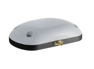
    The Trimble AX60 is a versatile system that can be operated at up to 15,500 feet above ground level (AGL), which meets the requirements for aerial survey projects such as wide area mapping, corridor mapping and remote sensing. Together with integrated flight planning and analysis software tools, the platform has been specifically designed as end-to-end solution that provides enhanced mission flexibility, rapid and efficient point cloud capture, excellent resolution, in-service reliability and high-productivity workflows. The Trimble AX60 can be installed on either fixed wing or rotary aircraft.

    The AX60 has a 400-kHz laser pulse repetition rate (PRR) with a single channel downward-looking laser. An optional, fully calibrated 80-megapixel camera with forward motion compensation can be added. The camera is integrated into the sensor head package and harmonized with the laser system so that it does not need re-calibration each time the solution is fitted to an aircraft. Another key feature is Trimble’s rotating polygon mirror technology for beam deflection that can allow survey missions to be completed faster. This technology provides higher accuracy and a uniform distribution of laser points across the entire field-of-view to widen the usable swath width. Operators can reduce track overlap or duplication, or fly at higher altitudes to achieve a given resolution. Together with a high precision positioning system, integral power supplies, and an in-flight monitoring tool, the Trimble AX60 can allow operators to lower the complexity of airborne LIDAR surveys while increasing the quality of the output.

    “The performance, operational flexibility and reliability of the Trimble AX60 make it an ideal solution for aerial survey companies,” said Phil Sawarynski, business area director of Imaging Solutions for Trimble’s Geospatial Division. “In addition, the Trimble AX60 has been designed as a true end-to-end solution, which includes field-proven Trimble flight planning software and Trimble Inpho analysis software. Since the hardware and software are all supplied by Trimble, operators can have confidence that the complete solution works together seamlessly, and that the flight planning and post-mission analysis suites can enable them to provide a high quality service to their customers.”

    In conjunction with the new airborne laser scanner launch, Trimble also announced its Inpho version 5.6 processing software suite. Version 5.6 now includes the UASMaster module, which has been designed for the complete processing of data acquired by remote piloted aircraft systems (RPAS/UAS). The module georeferences RPAS/UAS images and generates point clouds and othophoto mosaics that allow users to create high quality deliverables for CAD and GIS applications. The UASMaster module is fully compatible with Inpho photogrammetric software modules.

    The Trimble AX60 solution is expected to be available in the first quarter of 2014 through Trimble’s Geospatial Division distribution network. The Inpho version 5.6 and UASMaster is expected to be available in the fourth quarter of 2013.

  • Arithmetica to Launch Pointfuse Modeling Engine at Intergeo

    A vector model displayed in orthographic projection.
    A vector model displayed in orthographic projection.

    Arithmetica will be demonstrating Pointfuse at Intergeo, which is being held this week in Essen, Germany.

    Pointfuse is a powerful modeling engine that has been created to give professionals a fast, precise and flexible way of turning vast point cloud data sets (whether derived from LIDAR or photogrammetry) into high-fidelity vector models, the company said.

    Replacing painstaking and costly manual modeling, Pointfuse uses advanced techniques at the interface of mathematical optimization and computational statistics to automatically and rapidly convert point clouds into accurate vector models that can then be manipulated using any industry-standard CAD system.

    Pointfuse is fully mobile compatible, and can process data from mobile scanners as easily and quickly as from terrestrial or airborne systems. Results can be output and used on standard handheld mobile devices, making it  useful for creating and viewing highly detailed models in the field.

    A point cloud image of a motorway with crash barriers extracted and highlighted by Pointfuse. Data courtesy of Blom Aerofilms Ltd.
    A point cloud image of a motorway with crash barriers extracted and highlighted by Pointfuse. Data courtesy of Blom Aerofilms Ltd.

    The software will also fully automate extraction of features from point cloud data, allowing the intelligent recognition, measurement and cataloguing of objects and built environments, and other forms of extracted knowledge.

    George Skrobanski, chief technical officer of Arithmetica, explains the significance of this development. “Achieving the automatic extraction of features from point cloud data has been the Holy Grail for the industry. Pointfuse uses its proprietary technology to provide true automation and we believe this changes the game.”

    At Intergeo, learn more at Arithmetica’s booth (Hall: 3 – Booth: D3.046).

  • Orbit GT Showcases Clearance Checker for Mobile Mapping at Intergeo

    Orbit-GT_Clearance-Checker-for-Mobile-Mapping

    Orbit GeoSpatial Technologies will be presenting the Clearance Checker for Mobile Mapping at this year’s Intergeo, being held this week in Essen, Germany.

    “The Clearance Checker is an automatic detection tool that uses any mobile mapping lidar data to check clearances in height and width over any designated trajectory,” said Peter Bonne, vice president of business development and senior product manager at Orbit GT. “With the Clearance Checker, a vehicle contour of any designed size, is virtually driven through the point cloud over a chosen trajectory. Any collision or near-collision is automatically detected and listed for reporting, interpretation and subsequent actions. This tool is a must have for all rail- or tramway exploitation, oversize transport planning, and indeed every road and railroad maintenance or improvement project. This tool is an add-on to the Mobile Mapping Asset Inventory solution and is the first in a range of automated and semi-automated detection tools to be made available in shortly.”

  • Bluesky Announces International Expansion at Intergeo 2013

    Bluesky_Intergeo_WUsing an airborne mapping system, aerial surveying company Bluesky is expanding its international operations. The integrated system, developed by Optech, includes a LiDAR and fully integrated thermal sensor and high-resolution camera.

    Bluesky is exhibiting at Intergeo 2013, being held this week in Essen, Germany.

    Already proven in the UK the system, thought to be a world first, has already been successfully deployed in Northern Europe with additional projects proposed in Central Europe and the Middle East. The Bluesky system combines the Orion M300 LiDAR, CS-LW640 Long Wave Infrared thermal sensor and a CS-10000 RGB camera.

    “The integrated Optech system has been very successfully used for many projects in the UK and the results have provided our customers with the highest quality data as well as economic advantages due to the simultaneous capture of multiple data types,” commented Rachel Tidmarsh, Managing Director of Bluesky International. “We are now in a position to offer these advantages to potential customers around the world.”

    “Bluesky is the perfect example of an organization with the talent and vision to take full advantage of the unique capabilities of the latest Optech sensors. In addition, we are pleased that the ultra-compact and modular design of the system has made it portable and easy to install for them, further supporting Bluesky in their ambitious plans to expand their operations beyond the UK,” added Bill Sharp, Marketing Manager at Optech, Inc.

    The Optech solution used by Bluesky includes an Orion M300 LiDAR (Light Imaging Detection and Ranging) system; which uses aircraft mounted lasers to accurately determine the distance between the sensor and the ground or other targets such as buildings and vegetation. Specifically designed to offer a cost effective, high performance solution at mid altitudes, the Orion M300 is ideally suited for applications such as infrastructure modelling and environmental monitoring, including flood risk analysis and forestry management.

    The Optech CS-LW640 sensor records thermal infrared measurements and has already generated impressive results for recent projects. In upcoming projects it will be used for identifying heat loss from buildings, pipeline monitoring and forestry analysis. Like the CS-10000, it can be used simultaneously with the LiDAR or independently to fit the end user requirements. In addition to capturing thermal images of the target sites, the CS-LW640 camera can be mounted simultaneously with the other two sensors, providing customers with a wealth of coincident information for their area of interest; a complete solution, including highly efficient automated data processing, resulting in substantial acquisition savings.

  • Hemisphere GNSS Launches New Branding, Website

    Hemisphere GNSS Launches New Branding, Website

    The new Hemisphere GNSS logo.
    The new Hemisphere GNSS logo uses only the word Hemisphere.

    Today, Hemisphere GNSS introduced its new “Hemisphere” corporate branding and logo to reflect its global GNSS focus. The company is also announcing a new website that has been built from the ground up based on customer and partner input.

    In February 2013, Hemisphere GPS was renamed and incorporated as Hemisphere GNSS Inc. The company owns both names, but in order to reflect the company’s support of all Global Navigation Satellite Systems (GNSS) and update the company image, Hemisphere GNSS Inc. will be adopting the use of the new “Hemisphere” logo.

    “We are pleased to have completed our transition from a GPS agriculture-focused organization to a truly global GNSS Technology and Applications company. Today we are reaffirming our commitment to offering the best value in GNSS OEM boards, antennas, marine positioning, survey, mapping, and machine control products,” said Phil Gabriel, president at Hemisphere GNSS. “We are now introducing our new stylized globe logo and our updated branding to simply read ‘Hemisphere,’ as well as our new website and URL; www.HemisphereGNSS.com.

    The new website is easier to navigate and will assist customers in finding the information they need in a shorter amount of time, the company said. Employee email addresses are also being updated to first name initial, last name @HemisphereGNSS.com, though old email addresses will continue to work for the foreseeable future.

    HemisphereGNSS-W

  • SkyTraq Introduces Venus816, Dual-Antenna Supporting GPS Receiver

    The Venus816 on a penny.
    The Venus816 on a penny.

    SkyTraq Technology Inc., a fabless GNSS positioning technology company, today introduced highly integrated Venus816 single-chip GPS receiver capable of supporting dual passive antenna and active antenna inputs, automatic switching from passive antenna to active antenna, and active antenna short circuit protection without needing extra external components. It offers low BOM cost for antenna-embedded GPS products needing external active antenna option.

    The Venus816 includes two RF inputs with integrated antenna switching and external active-antenna current detection. A high-linearity on-chip 20dB gain 0.9dB noise figure LNA is used with one of the inputs, offering cascaded system noise figure of 1.2dB, allowing Venus816 to be used with passive antenna without the need for additional external LNA device.

    The Venus816 works with GPS, QZSS, and SBAS signals, features industry leading 40Hz update rate, 29sec cold start TTFF, -148dBm cold start sensitivity, -165dBm tracking sensitivity, multipath suppression, jamming mitigation and reporting.

    It is comes in 5mm x 5mm QFN40 package. A minimum of 6 external components is needed to form a working GPS receiver.

    Venus816 engineering sample, evaluation kit, datasheet and reference design are available in late of October; mass production begins in November.

  • Leica Zeno GG03 SmartAntenna for GIS Asset Collection Earns IP68 Certification

    Leica Zeno GG03 SmartAntenna for GIS Asset Collection Earns IP68 Certification

    Photo: Leica Zeno GG03 SmartAntennaWith its recent Ingress Protection (IP) certification, the Leica Zeno GG03 SmartAntenna is now an IP68-certified SmartAntenna for GIS applications. IP68 represents the top rating for protection against dust, moisture and water. Meeting the tough standards for Ingress Protection (IP) makes the Leica Zeno GG03 a rugged GNSS SmartAntenna for GIS asset collection and management tasks.

    The upgradable Leica Zeno GG03 SmartAntenna is designed for organizations that require a compact and lightweight device for accurate and reliable positioning. The robust design of the Zeno GG03 brings further advantages when collecting GIS assets by offering reliable and rugged operation in extreme environments, even after continued exposure to water and dust.

    “The Leica Zeno GIS series is used all over the world in the most demanding environments,” said Product Manager Johannes Hotz. “The IP68 rating further underlines the quality and robustness of the Leica Zeno GG03. The industry-leading GNSS performance and an unmatched ultra-rugged design is a big win for our customers in the field.”

  • Global Mapper V15 Released with Extension Interface and Powerful New LiDAR Tools

    Blue Marble Geographics announces the release of Global Mapper version 15. This major release includes many powerful updates along with a new extension interface that provides add-on functionality capabilities including the COAST tool and a new LiDAR Module. Blue Marble’s geospatial data manipulation, visualization and conversion solutions are used worldwide by thousands of GIS analysts at software, oil and gas, mining, civil engineering, surveying, and technology companies, as well as governmental and university organizations.

    GlobalMapper_Augusta_LiDAR_s

    According to the announcement, the new extension interface in Global Mapper 15 allows third parties and customers the opportunity to create add-on applications that can be part of the software with access to all the formats and tools that Global Mapper has to offer. As part of this release, Blue Marble has created three modules; The COAST tool for cost/benefit analysis of coastal flooding incidents, an Overview Map Window application, and a new powerful LiDAR module. The LiDAR module is available for the price of another seat of the software, while COAST and the Overview Application are free. Other new extension modules from key partners are expected over the next year.

    This release also features a new Mathematical Raster Calculator for multi-band imagery analysis, the ability to edit and re-calculate multiple view shed layers, 3D PDF read/write support, scripting enhancements, such as passing variables to the script from the command line, and much more. The LiDAR Module is a powerful toolbar that has totally new functionality on par with software that is many thousands of dollars more expensive. Leveraged through a toolbar for easier management and editing capabilities, the module features the ability to view, edit and reclassify points in the Path Profile viewer, robust gridding techniques for faster, extremely flexible creation of elevation surfaces, including smart decimation through binning, and other techniques. The tool also allows for automatic classification of ground points from unclassified point clouds, and support for reporting LiDAR statistics via script to a text file to facilitate QA processes and new format support for E57 LiDAR.

    “Global Mapper is TRULY the GIS tool for everyone and that includes the basic user who simply needs to view data or output it to Google Earth, as well as the highly trained GIS or Survey professional working with LiDAR point clouds of a billion points or more,” stated Blue Marble’s President Patrick Cunningham “We are committed to adding the most advanced functionality at a price point that is within reach of everyone and we have again done so with this release.”

  • PCTEL Launches Antennas for GPS, GLONASS, BeiDou, and Galileo Apps

    PCTEL's new timing antenna, the GNSS1-TMG-26N.
    PCTEL’s new timing antenna, the GNSS1-TMG-26N.

    PCTEL, Inc. announced the launch of its next generation multi-band GNSS antennas for global timing and precision tracking applications at the ION GNSS Conference being held this week in Nashville, Tennessee.

    The new antennas, which are designed for use with GPS, GLONASS, BeiDou, and Galileo systems, are being showcased along with other PCTEL antennas at the PCTEL booth in the Exhibit Hall, Booth 318/320. All models of the new antennas are available for sale.

    Equipment providers for carrier network timing, precision agriculture, and global asset tracking applications need a single antenna solution for global deployment. PCTEL’s new GNSS1-TMG-26N and GPS-LB12GL-MAG antennas address global compatibility issues for two of the industry’s most crucial applications.

    For critical timing applications for macro and small cell deployments, PCTEL has developed the GNSS1-TMG-26N antenna. The GNSS1-TMG-26N is a fixed mount network timing antenna covering GPS, GLONASS, Beidou, and Galileo system frequencies in one single unit, making it a true global solution.

    PCTEL's  GPS-LB12GL-MAG antenna is designed for precision agriculture.
    PCTEL’s GPS-LB12GL-MAG antenna is designed for precision agriculture.

    For global precision navigation applications, PCTEL has developed the GPS-LB12GL-MAG to cover GPS L1, GPS L2, GLONASS, and L-BAND constellations. The GPS-LB12GL-MAG’s multi-band coverage addresses the precision market in the USA as well as differential correction signals needed across Europe and Asia.

    “PCTEL will meet the GNSS market requirements for our global customers while maintaining PCTEL’s high standards for quality and performance,” said Jeff Miller, president of PCTEL Connected Solutions. “We understand that our products need global compatibility to support our customers around the world. We are proud to showcase our design excellence in this highly technical area,” added Miller.

  • AFIT, Locata Partner on GPS Technology Development

    AFIT, Locata Partner on GPS Technology Development

    Locata's new VRay Orb 80 switching antenna.
    Locata’s new VRay Orb 80 switching antenna.

    The Air Force Institute of Technology (AFIT) and Locata Corporation have signed a Co-operative Research & Development Agreement (CRADA) to build and demonstrate new Locata multipath mitigation technology for use in GPS receivers. This cooperation is expected to leverage many years of proprietary Locata ground-based technology development to bring completely new capabilities to satellite-based GPS receivers, AFIT said.

    The Air Force Institute of Technology, or AFIT, is the Air Force’s graduate school of engineering and management as well as its institution for technical professional continuing education.

    The CRADA is specifically directed to evaluate Locata’s patented correlator and switching antenna technologies for use in positioning receivers running at GPS frequencies. Locata’s engineers will transfer knowledge and experience they have gained with existing Locata commercial systems to help AFIT design and build an initial multi-element GPS-based switching antenna prototype which is based on Locata’s patents. This will ensure AFIT researchers and engineers can familiarize themselves with the new antenna’s characteristics, and provide AFIT with an essential platform to develop GPS-specific versions of Locata’s correlator and switching algorithms. When built, AFIT intends to use its GPS receiver and the prototype switching antenna to physically demonstrate the feasibility of using Locata technology to improve GPS receiver performance.

    An animation was created specifically to explain RF problems created by multipath and Locata’s VRay solution. The animation shows the first proof-of-concept 2D, 64-element antenna Locata’s engineers prototyped in 2011.

    After initial prototypes are built, AFIT plans to design and test several other GPS-based versions of Locata’s switching antenna array to assess how Locata’s commercial antennas can be adapted to use cases which are of particular interest to the military. Designs already discussed with Locata include stand-alone antennas, arrays conformal to a vehicle’s frame (such as a Humvee’s roof or aircraft fuselage), and a version built into helmets.

    As a first step in implementing this CRADA collaboration, AFIT personnel visited Locata’s head office the week of April 29 for a detailed, wide-ranging introduction to the design fundamentals for this new type of antenna. Locata hosted AFIT’s John Raquet, Peter Collins and Jason Barhorst (see picture) in multiple engineering meetings where Locata’s current production version antenna was revealed for the first time, and then closely analyzed. AFIT and Locata engineers then workshopped the modification and design choices required to integrate Locata design into a GPS form-factor.

    “If this CRADA is successful, Locata’s technology could enable a significantly improved technical performance and reduction in the cost of multiple-element GPS antennas,” said John Raquet, director, Advanced Navigation Technology Center, AFIT. “This will enable much wider adoption of the technology, resulting in more reliable GPS positioning for more users. We are excited to investigate this technology advance for the benefits it will potentially bring to American warfighters.”

    “We are incredibly proud to once again be involved in a CRADA with the Air Force Institute of Technology, developing on the cutting-edge of navigation technology,” said Nunzio Gambale, CEO and co-founder, Locata Corporation. “Our previous LocataNet partnership with Dr. Raquet and his world-class AFIT researchers quickly taught us why this team is renown throughout the industry. The AFIT engineers bring an exceptional skill base to this important integration of Locata technology into GPS receivers. I’m certain that our collaboration, along with access to the USAF’s unmatched prototyping and testing capabilities, will deliver ground-breaking functionality for future GPS devices.”

    AFIT expects at least one master’s degree to be awarded for the research tasks involved in the CRADA. Work against the approved CRADA project plan will commence immediately, and involve several other participants providing admin and lab support to AFIT and Locata. The final report produced by this CRADA will include results and measured performance of the Locata-enhanced GPS receiver and other design considerations gleaned from AFIT’s experience with the new Locata antenna and correlators.

     AFIT-Locata Kick-off Meeting. This is the first picture ever released by Locata which shows their radically new switching antenna, a design that AFIT will now modify for use with GPS receivers. Pictured (L-R): Dr. Steve Hewitson & Ian Sainsbery (Locata engineers); Jason Barhorst (AFIT); David Small (Locata technology inventor), Nunzio Gambale (Locata CEO), Dr. John Raquet (Director, Advanced Navigation Technology Center, AFIT), Dr. Peter Collins (AFIT), Dr. Trevor Hobbs (Locata Director of R&D).
    AFIT-Locata Kick-off Meeting: This is the first picture ever released by Locata which shows their radically new switching antenna, a design that AFIT will now modify for use with GPS receivers. Pictured (L-R): Dr. Steve Hewitson & Ian Sainsbery (Locata engineers); Jason Barhorst (AFIT); David Small (Locata technology inventor), Nunzio Gambale (Locata CEO), Dr. John Raquet (Director, Advanced Navigation Technology Center, AFIT), Dr. Peter Collins (AFIT), Dr. Trevor Hobbs (Locata Director of R&D).
  • Geospatial on Everything

    By Alan Cameron

    Everything has a geospatial aspect. Everything.

    Over grits, coffee, and the airborne delicacy purveyed at the Flying Biscuit Cafe (right out of the oven, right into your mouth) in Sandy Springs, Georgia, I absorbed this high-tech homily.

    You’ve heard of the European financial crisis. Trace it back to geospatial, from the Greek banking collapse, which in turn had roots in the implosion of the Greek tax system, due to a plethora of gaps, inconsistencies, and exceptions filed in a largely uncontrolled property cadastre — the register of real property, including details of ownership, precise location (by GPS coordinates), and value of land parcels.

    Lose control of your cadastre (your GIS), lose the country. With global interconnections, soon the continent, if not perhaps the world economy.

    For want of a nail, the battle was lost.

    Jump forward, technologically, to flash lidar. Ball Aerospace created this ability to capture continuous rapid multiple laser interferometry detection and ranging (LiDAR) images/point clouds, merged with continuous high-resolution optical images, to create full-color 3D models in real time. Stitched together with GPS, this produces real-time full-motion video: interactive geo-referenced metric 3D models.

    In field application, this can yield time-critical 3D mapping for urgent missions, enhanced situational awareness, battlefield characterization, and tactical mission planning. It can help with disaster-response planning and event forensics. Real-time models could be communicated with the public through easily comprehended moving images via television or the Internet. of the actual progress of a fire or flood, together with evacuation routes.

    Jump again to fabfi. What’s a fabfi?

    FabFi is an open-source, lab-grown system out of MIT using common building materials and off-the-shelf electronics to transmit wireless Ethernet signals across distances up to several miles. Communities can build their own networks for high-speed Internet connectivity, and access to online educational, medical, and other resources.

    Simple, low-cost, and feasible in unstable environments: Afghanistan, Kenya, and any number of countries that leapfrogged telephone landlines to come quickly into the cellular era; now they can leapfrog Ethernet cable networks and even WiFi for virtual connectivity. Implement with locally available materials. Print out a 2D design file and create the pieces out of wood, metal, acrylic, clay, stone, or ice, as long as you can attach a metallic RF reflective surface to the front.

    If you haven’t guessed the geospatial aspect of this, I assure you it’s there, but I’ve run out of room here.

    For these geospatial glimpses, I am indebted to contributing editor Art Kalinski. Read his monthly columns here.


    Alan Cameron is editor-in-chief and publisher of GPS World magazine, where he has worked since 2000. He also writes the monthly GNSS System Design e-mail newsletter and the Wide Awake blog.

  • Panasonic Offers Durable Antennas for Wireless

    Panasonic Offers Durable Antennas for Wireless

    The VIC100 Series antenna by Panasonic

    The VIC100 Series antenna by Panasonic is an active L1 GPS antenna designed for timing and synchronization. It offers immunity to noise and interference, and secure performance by attenuating noise and interference near the GPS L1 frequency through triple-filtering design.

    The VIC100 Series is housed in a waterproof enclosure designed for excellent performance under severe environmental conditions. Its shape prevents accumulation of snow and ice, eliminating problems with bird perching and enhanced immunity to lightning surge.