Category: Survey

  • Hemisphere GNSS Launches New Branding, Website

    Hemisphere GNSS Launches New Branding, Website

    The new Hemisphere GNSS logo.
    The new Hemisphere GNSS logo uses only the word Hemisphere.

    Today, Hemisphere GNSS introduced its new “Hemisphere” corporate branding and logo to reflect its global GNSS focus. The company is also announcing a new website that has been built from the ground up based on customer and partner input.

    In February 2013, Hemisphere GPS was renamed and incorporated as Hemisphere GNSS Inc. The company owns both names, but in order to reflect the company’s support of all Global Navigation Satellite Systems (GNSS) and update the company image, Hemisphere GNSS Inc. will be adopting the use of the new “Hemisphere” logo.

    “We are pleased to have completed our transition from a GPS agriculture-focused organization to a truly global GNSS Technology and Applications company. Today we are reaffirming our commitment to offering the best value in GNSS OEM boards, antennas, marine positioning, survey, mapping, and machine control products,” said Phil Gabriel, president at Hemisphere GNSS. “We are now introducing our new stylized globe logo and our updated branding to simply read ‘Hemisphere,’ as well as our new website and URL; www.HemisphereGNSS.com.

    The new website is easier to navigate and will assist customers in finding the information they need in a shorter amount of time, the company said. Employee email addresses are also being updated to first name initial, last name @HemisphereGNSS.com, though old email addresses will continue to work for the foreseeable future.

    HemisphereGNSS-W

  • Leica Zeno GG03 SmartAntenna for GIS Asset Collection Earns IP68 Certification

    Leica Zeno GG03 SmartAntenna for GIS Asset Collection Earns IP68 Certification

    Photo: Leica Zeno GG03 SmartAntennaWith its recent Ingress Protection (IP) certification, the Leica Zeno GG03 SmartAntenna is now an IP68-certified SmartAntenna for GIS applications. IP68 represents the top rating for protection against dust, moisture and water. Meeting the tough standards for Ingress Protection (IP) makes the Leica Zeno GG03 a rugged GNSS SmartAntenna for GIS asset collection and management tasks.

    The upgradable Leica Zeno GG03 SmartAntenna is designed for organizations that require a compact and lightweight device for accurate and reliable positioning. The robust design of the Zeno GG03 brings further advantages when collecting GIS assets by offering reliable and rugged operation in extreme environments, even after continued exposure to water and dust.

    “The Leica Zeno GIS series is used all over the world in the most demanding environments,” said Product Manager Johannes Hotz. “The IP68 rating further underlines the quality and robustness of the Leica Zeno GG03. The industry-leading GNSS performance and an unmatched ultra-rugged design is a big win for our customers in the field.”

  • u-blox Releases Improved Sub-Meter GPS Positioning Module NEO-7P

    u-blox Releases Improved Sub-Meter GPS Positioning Module NEO-7P

    NEO-7P
    The NEO-7P sub-meter GPS positioning module with Precise Point Positioning (PPP) and Differential GPS.

    Swiss-based u‑blox has introduced the NEO-7P, an improved, low-power, compact, high-precision GPS module. While remaining backwards compatible with its predecessor NEO-6P, the new module achieves standalone sub-meter precision based on single-frequency precise point positioning (PPP) technology.

    Fully autonomous sub-meter performance can be realized for most outdoor applications within coverage of Satellite Based Augmentation Systems (SBAS) throughout North America (WAAS), Europe (EGNOS), and Japan (MSAS).

    In areas where SBAS is unavailable, the NEO-7P achieves high-accuracy based on Differential GPS (DGPS) positioning as an alternative to PPP. DGPS uses RTCM correction messages (correctional data defined by the Radio Technical Commission for Maritime Services) from a local reference station or aiding network to cancel out measurement error introduced by atmospheric distortion and variances in satellite orbits and clocks.

    “The NEO-7P addresses many requirements for precise positioning used in surveying, mapping, marine, and clear-sky recreational applications,” said Thomas Nigg, VP product marketing at u-blox. “The solution delivers sub-meter positioning performance based on two techniques at a fraction of the cost of other high precision solutions. The solution is compact, requires no external base station, and uses a single frequency receiver.”

    The device comes in u-blox’ compact NEO Leadless Chip Carrier (LCC) module form factor. A UART, USB and I2C interface provide flexible connections to a host processor. It can also communicate directly with u‑blox’ SARA 2G, LISA 3G and TOBY LTE cellular modules.

    The NEO-7P also provides complete GPS satellite raw data allowing further accuracy improvement based on post processing by an external host. Internal Flash memory allows simple firmware upgrades. The NEO-7P also supports Russian GLONASS Japanese QZSS positioning standards.

    The module is suitable for vehicle, industrial and consumer applications.

    Detailed information about the NEO-7P can be found on the u-blox website.


  • New JAVAD TRIUMPH-LS Receiver Features 864 Channels

    New JAVAD TRIUMPH-LS Receiver Features 864 Channels

    The TRIUMPH-LS receiver, by JAVAD GNSS.
    The TRIUMPH-LS receiver, by JAVAD GNSS.

    JAVAD GNSS has launched a new version of the TRIUMPH GNSS receiver, which features 864 channels — more than any receiver it has yet offered. The TRIUMPH-LS land survey receiver offers, in addition to the 864 GNSS channels, three powerful processors, 256 I/O, 24 digital filters, 24 anti-jam filters and 14-MB program memory all in a single chip, which uses less power and makes the total system less expensive, according to the company.

    The announcement was made at the ION GNSS+ Conference, being held this week in Nashville, Tennessee.

    Javad Ashjaee, CEO and founder, explained the decision to incorporate 864 channels. “Some questioned the need for the 216 channels. They now realize the need for 440 channels. We assign multiple channels to each satellite for redundancy and reliability. We use more than 100 channels to scan GNSS bands for interference — 864 channels is the key to reliable performance.”

    The TRIUMPH-LS provides visual stake-out, six parallel RTK engines, more than 3,000 coordinate conversions, advanced coordinate geometry features, and rich attribute tagging on a high-resolution 800 x 480 pixel display. When used in photogrammetry, offsets can be calculated using the internal camera for 10-centimeter accuracy, or an external camera for 5-centimenter accuracy. TRIUMPH-LS is the first JAVAD GNSS receiver to offer photogrammetry for land survey.

    Other features include versatile attribute tagging, feature coding, automatic photo and voice documentation, and an interference monitoring and reporting feature.

    The TRIUMPH-LS  has a battery life of 25 hours in RTK rover mode with full screen brightness and UHF/GSM. Two hours of charge equals two days of surveying. The internal batteries are field serviceable and can be easily replaced by the user when needed.

    The TRIUMPH-LS, including batteries and pole, is the lightest GNSS RTK receiver in its class, according to JAVAD GNSS. The total weight of the system — including radio, controller, pole and 25 hours of internal battery — is 2.5 kilograms.

    Built on a tough magnesium alloy chassis, all connectors, SIM cards, and micro-SD cards are protected against harsh environmental conditions. The pole can be collapsed and the unit can easily fit in a car seat — there are no long poles and no separate controller or brackets to disassemble.

    The TRIUMPH-LS automatically updates all firmware when connected to the Internet via Wi-Fi. The built-in GNSS full tracking antenna has a large ground place and excellent centering and rotational performance.

    To learn more about the TRIUMPH-LS, stop by the JAVAD GNSS booth (Booth D) in the ION GNSS+ Exhibit Hall now through Friday.Presentation will be given Thursday at the conference room of the exhibition hall at 2:00 pm.


  • Trimble Introduces Compact OEM Module with Triple Frequency GNSS Support

    The Trimble BD930 chip.
    The Trimble BD930 chip.

    Trimble today introduced the Trimble BD930 module as part of its GNSS OEM portfolio. This small module features triple-frequency support for GPS and GLONASS plus dual-frequency support for BeiDou and Galileo constellations. Capable of receiving a wide range of commercially available GNSS signals, the 220-channel BD930 takes advantage of all available signals to provide optimal and reliable RTK centimeter positioning.

    The announcement was made today at ION GNSS 2013 Conference and Exhibition.

    “The OEM and system integrator communities trust Trimble to supply high performance, accurate and reliability positioning solutions for their systems,” said Ed Norse, portfolio manager of Trimble’s GNSS OEM modules. “The Trimble BD930 delivers the latest GNSS technology in an easy-to-integrate form factor for demanding conditions and applications such as high-precision navigation and control, robotics and lightweight unmanned vehicles.”

    The triple-frequency Trimble BD930 (measuring 41 x 51 millmeters) is a small, yet powerful GNSS module specifically designed for applications requiring high accuracy in a compact package. Form-Fit-Function compatible with the Trimble BD920 receiver, the module tracks all available GNSS constellations including GPS, GLONASS, Galileo and BeiDou.

    The BD930 is designed for all levels of accuracy with an advanced engine that provides GNSS, DGNSS and RTK positioning in challenging environments such as under tree canopy and urban canyons. The BD930 allows for easy integration and rugged dependability. Flexible connectivity options — Ethernet, RS232 or USB — provide fast data transfer and easy configuration via standard Web browsers. External 10 MHz frequency input is supported for advanced applications.

    The Trimble BD930 module is expected to be available in the fourth quarter of 2013 through the Trimble Precision GNSS + Inertial worldwide sales channel.


  • Trimble Adds Galileo and BeiDou MEO Satellite Preview to CenterPoint RTX

    Trimble Adds Galileo and BeiDou MEO Satellite Preview to CenterPoint RTX

    The preview version of Trimble's CenterPoint RTX post-processing service, enabling GNSS observations using available Galileo and BeiDou MEO satellites.
    The preview version of Trimble’s CenterPoint RTX post-processing service, enabling GNSS observations using available Galileo and BeiDou MEO satellites.

    Trimble announced today a Preview version of its CenterPoint RTX post-processing service, enabling GNSS observations using available Galileo and BeiDou Middle Earth Orbit (MEO) satellites. Powered by Trimble RTX technology, the free CenterPoint RTX post-processing service provides better than centimeter level positions.

    The announcement was made today at ION GNSS 2013 Conference and Exhibition.

    The existing CenterPoint RTX post-processing site uses data from the GPS, GLONASS, and QZSS satellite systems. Through a link accessible from the post-processing website, users can enter a Preview site and derive positions that also use data from available open service Galileo and BeiDou MEO satellites.

    “With the addition of Galileo and BeiDou MEO support, we offer researchers, scientists and academics the opportunity to evaluate and experiment with results from these evolving satellite constellations,” said Patricia Boothe, general manager of Trimble’s Positioning Services Division. “We are committed to continuing to advance CenterPoint RTX post-processing and the underlying Trimble RTX technology to enable ever higher accuracy positioning solutions.”

    Trimble CenterPoint RTX post-processing is a cloud-based service accessed through www.TrimbleRTX.com. Users around the globe can upload static GNSS observation data and receive positioning corrections calculated in the well-defined International Terrestrial Reference System (ITRF) 2008 reference frame. The post-processed solution can be transformed to a variety of regional reference frames by selecting a coordinate system and tectonic plate.

  • SBG Systems Releases Ekinox Land Solution

    SBG Systems Releases Ekinox Land Solution

    The Ekinox Land Solution by SBG Systems.
    The Ekinox Land Solution by SBG Systems.

    At ION GNSS+ this week, SBG Systems announced the release of the Ekinox Land Solution, an all-in-one solution combining the cost-effective inertial navigation system with an odometer, and a GNSS RTK reference station for smooth positioning in land applications. GPS positioning in urban canyons, forests, or tunnels has always been challenging. By taking the best of these complementary technologies, Ekinox Land Solution provides reliable positioning in an affordable package, the company said.

    SBG Systems is exhibiting the system Wednesday through Friday at Booth 519/521 at ION GNSS+ in the Nashville Convention Center.

    The combination of the Ekinox inertial navigation system with complementary technologies such as wheel-speed sensor (DMI) and RTK GNSS is the key to providing smooth vehicle positioning, even during GPS outages, SBG Systems said. To save users and integrators both time and money, the best equipment has been tested and selected to build a cost-effective and all-in-one package — Ekinox Land Solution.

    Ekinox Land Solution is an integrated package built from the Ekinox Series, a range of inertial navigation systems based on robust and cost-effective MEMS technology. Mounted on a vehicle, Ekinox Land Solution provides real-time roll, pitch, and true heading (0.05° accuracy) while delivering a smooth position (2 cm). Data is output at 200 Hz and recorded in an 8-GB datalogger. Post-processing software is offered to increase attitude accuracy (up to 0.02°).

    Ekinox Land Solution is designed to answer the growing need of vehicle real-time positioning, imagery sensor triggering, and data georeferencing at an affordable price. Examples of applications include mobile mapping, machine control, car motion analysis, and unmanned ground vehicle navigation.

    The Ekinox series includes the Ekinox-A, and Attitude and Heading Reference System; the Ekinox-E, an Inertial Navigation System (INS) whose position feature depends on aiding equipment; the Ekinox-N, an INS with an embedded L1/L2 GNSS receiver; and the Ekinox-D, an INS with an integrated Dual Antenna GNSS receiver.

    SBG Systems is a French supplier of MEMS-based inertial motion sensing solutions. The company provides a wide range of inertial solutions from miniature to high accuracy. Combined with calibration techniques and advanced embedded algorithms, SBG Systems products are designed for defense, industrial and research projects, such as unmanned vehicle control, antenna tracking, camera stabilization, and surveying applications.


  • Kickstarter Comes to GPS; Plus, Jammers and Field Technology Conference

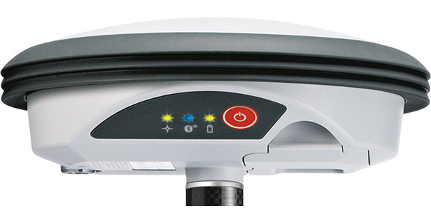
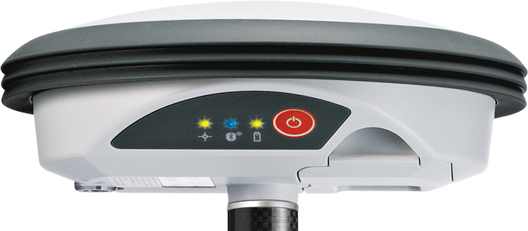
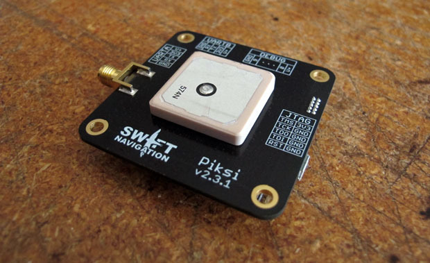
    $2,000 for an RTK base and rover? Yes, it’s real. Well, at least it seems real.

    For $2,000, you can order an RTK base and rover set named Piksi, including radios.

    Photo: Piksi (Swift Navigation)  Piksi_rugged

    It’s an intriguing opportunity, and might be the first brush stroke of the picture I’ve been painting (metaphorically speaking) for the past few years about inexpensive RTK receivers forthcoming. But, before you get really excited, read on.

    Besides the attractive price, something else that makes Piksi interesting is the way the company is financed. The way that a typical company funds new product development is through its own cash flow or financing. The company designs and produces a product, then announces it to potential buyers (you), who then touch, feel and use the product to understand how it performs…all before making the decision to purchase. Piksi (Swift Navigation) doesn’t follow that model.

    Piksi is using a new-age, crowd-sourced funding model called Kickstarter. With Kickstarter, a group of people (creators) offer to design and produce a certain product if they can recruit enough “investors” to fund their endeavor. The “investors” aren’t traditional venture capitalists, nor people who would own stock in said company. The investment is simply a commitment to buy the product based on the specifications provided by the creators, before the product is finished. If the company has enough commitments from “investors,” the creators commit to designing, building and delivering the product.

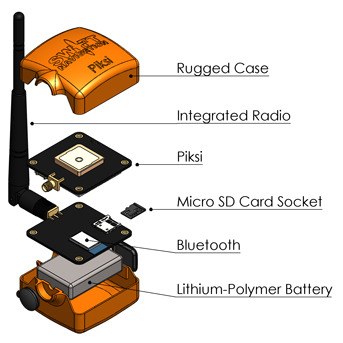
    Furthermore, there are certain levels of investment available for Piksi, from $7 which will get you a Swift Navigation micro-USB cable, to $2,000, which will get you a ruggedized version of the complete RTK kit, including base, rover, XBee radios, Bluetooth and SD card storage. So far, Swift Navigation has raised $161,369 towards the project with today, September 4, being the last day. That’s far more than the $14,000 goal it set.

    The caveat is that the product is not complete yet, at least the RTK portion. According to Swift Navigation:

    We have already built a small batch of Piksi receivers that are ready to ship and have locked down all part sourcing and manufacturing for further batches, so there are unlikely to be any unanticipated delays in the delivery of Piksi hardware.

    However, it’s difficult to know exactly how long the RTK functionality will take to implement — software development schedules seem to always run over their anticipated delivery dates, even when you take into account Hofstadter’s Law. We feel the goals we’re proposing to accomplish with this campaign are reasonable — adding a new set of software functionality (which we successfully implemented on a previous platform) upon an existing base of stable hardware and software.

    The gamble that the investor takes is that Swift will be able to finish the product, produce it, and meet the performance specifications. However, that’s only part of the battle. I spent better than 10 years of my life managing the design and production (somewhat) of GPS-based hardware and software for mapping and surveying. There are a million details. A major part of developing a hardware/software product like this is making it reliable. What I mean by reliable is that it behaves the same way every time you push the ON button, and works consistently and reliably all day until you press the OFF button. That’s not easy to achieve without a lot of sophisticated testing in different environments, and nothing can fix a poor reliability design (except a redesign).

    The guys behind the Piksi don’t seem to be total GPS-rookies, but do lack substantial real-world experience. Click here and then click on Bios to read about their backgrounds. But who knows? Maybe that’s an advantage, not being conditioned to “follow the rules.”

    One last note, and an important one. It’s only an L1 system, so don’t get too excited. L1 means that you really can’t use an RTK network (practically speaking) and that the baseline distance needs to be pretty short. The RTK initialization and re-initialization times will be measured in minutes, not seconds, and that’s assuming they get the RTK algorithms correct (and reliable).

    Sorry to burst your bubble.

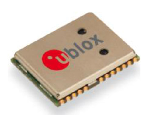
    Actually, the concept of an inexpensive, bootstrapped L1 RTK system is not difficult to envision. The GPS OEM boards are readily available, as well as the GPS antennae, wireless comms and the rest of the components. At the risk of sounding pompous, I could put that kind of project together. The trickiest part of the project would be developing/implementing reliable RTK software.

    No matter what, it will be interesting to hear about what these guys come up with. In the words of the late Steve Jobs, “stay hungry, stay foolish.”

    GPS jammers are cheap, but don’t get caught using one.

    Even though they are illegal to market, sell and operate in the U.S., Americans are buying cheap GPS jammers, via Internet stores, from companies operating outside of the U.S. Operating one of these devices in the U.S. is a risky venture (as you’ll read below).


    Although they don’t seem to be a serious threat yet, they could become a threat as GPS receivers become more ubiquitous and concerns about privacy continue to ramp up.

    The Federal Communications Commission (FCC) is responsible for enforcing the U.S. laws enacted that prohibit the use of GPS jamming devices. If you look at the FCC’s enforcement history here, you’ll see that there isn’t much enforcement activity. However, a recent enforcement action was imposed on a guy in New Jersey who made the mistake of driving by the Newark International airport with his GPS jammer turned on. Uh oh. The FCC tracked down the offender and issued a Notice of Apparent Liability for Forfeiture that included a fine of nearly $32,000. Whoa, that’s a lot of dough. Wonder if he is trying to sue the company he bought it from? Not likely, as they are most certainly outside of the U.S. and out of reach of the U.S. judicial system. Caveat emptor.

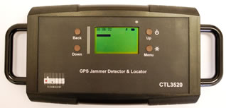
    You can be assured that if jamming reports increase, there will be more jamming detection and location equipment deployed to hold people accountable, like this new, handheld GPS jammer detector and locator from Chronos:

    Chronos_ctl3520

    You might want to visit this GPS.GOV website on GPS jamming. It contains a lot of information about the U.S. regulations surrounding the marketing, sales and use of GPS (and cell phone) jamming devices.

    Third annual Field Technology Conference

    FTC2013_logo

    In 2010, I, along with two colleagues, put together a conference here in Portland, Oregon, and named it the Field Technology Conference. We created the conference to focus on geospatial technology hardware and software used in the field. It’s the essence of what a conference should be, a group of people gathering to share ideas of common interest. It’s mostly devoid of commercial interests, save a few really neat (and valuable) giveaways and a few exhibit booths. You probably haven’t heard about the conference because we have a very small marketing budget, and the organizers (three of us) can only spend a few hours a month brainstorming, finding speakers, and organizing the event.

    This year, our third, will focus on existing and emerging technologies: GPS/GNSS, UAVs, 3D printing, mobile devices, imagery and geospatial software. Our outdoor demonstration area was very popular last year so we’ll offer that again, as well as a UAV demonstration. We’re also planning an on-site demonstration of 3D printing. Can you imagine 3D printing a topographic survey?

    Something new this year is our association with the CGSIC (Civil GPS Service Interface Committee). CGSIC is co-locating a regional event with our conference. What that means is that speakers from the U.S. government (Air Force, State Deptartment, DOT, etc.) will make GPS-centric presentations. CGSIC events are the only live communication channel between the U.S. Air Force GPS operations personnel and civilian GPS users. This is your chance to ask Air Force personnel questions, in person, that you’ve always wanted to know about GPS. If you’re unable to travel to Portland for the conference (October 23-24), GPS World magazine is planning on streaming the CGSIC presentations live over the Internet, as well as posting the recording on its website.

    Although the conference is organized by the Western Forestry and Conservation Association (which organizes a lot of conferences), take a look at the agenda and you’ll see the content will be of interest to anyone involved with geospatial data collection and processing technology, not just foresters and environmental scientists. For conference details, click here.

    Thanks, and see you next month.

    Follow me on Twitter at https://twitter.com/GPSGIS_Eric

  • Handheld Ships New Version of Algiz 7 Tablet

    Handheld Group has announced the launch of the new version of its popular Algiz 7 rugged tablet computer. The updated Algiz 7 is considerably faster than its predecessor, with better storage capacity, improved security and quicker communication capabilities.

    According to the announcement, the ultra-rugged Algiz 7 tablet PC is small, light and fast, with multiple connectivity options and a wide range of functions, ideal for field workers demanding a super-durable product that is tough and powerful, yet light and easy to work with. The Algiz 7 meets stringent MIL-STD-810G military standards for withstanding humidity, vibrations, drops and extreme temperatures, and with its IP65 rating it keeps dust and water out as well.

    Algiz-7-handheld-tablet-facing-left-newThe new Algiz 7, which started shipping this week, features the following improvements from earlier versions:

    • A fast and powerful N2600 1.6 GHz Dual-Core Intel ATOM processor.
    • More memory, with 4 GB of DDR3 RAM.
    • Better storage, with a 128GB SSD SATA II with recovery partition.
    • Two full mPCIe slots for improved flexibility.
    • Ethernet 10/100/1000 (Gigabit).
    • Added data security with TPM chipset board (chip 1.2).
    • An updated version of the wireless Gobi 3000 technology for higher communications speed.
    • A 5-megapixel camera.
    • Antenna diversity (two antennas) for improved coverage.

    “We’ve made significant improvements to the new Algiz 7,” said Jerker Hellström, CEO of Handheld Group. “Better storage, a much faster processor, improved security, a better camera and better communications are some enhancements – and we’ve kept the price point the same as for the previous version of the Algiz 7. This product should remain the tablet of choice for anyone looking for portable, professional field performance.”

    The Algiz 7 weighs 1.1 kilograms and has a 7-inch widescreen touch display that features the new and unique MaxView technology, providing brightness in outdoor conditions — even direct sunlight. It runs the state-of-the-art Microsoft Windows 7 Ultimate operating system. GPS navigation functionality is fully built in.

    The Algiz 7 is specifically developed for use in tough environments in industries such as mining, geomatics, logistics, forestry, public transportation, construction, utilities, maintenance, military and security.

  • Trimble Offers Site Positioning System for Small Construction Companies

    Trimble introduced today a Site Positioning System designed for owner operators, small site contractors or construction companies new to GPS. The Trimble Site Positioning System Essentials Kit is comprised of the new Trimble Site Mobile controller, Trimble SCS900 Site Controller Software and Trimble SPS985L GNSS Smart Antenna for a complete GPS positioning solution. Using GPS, a grade checker or site engineer can check a grade, slope or alignment more accurately and in less time than with traditional construction survey methods.

    “The Trimble Essentials Kit is an exciting new addition to our positioning portfolio,” said Elwyn McLachlan, business area director for Trimble Site Positioning Systems. “Budget-conscious contractors can realize a quick return on investment by giving more personnel on the job site access to technology, enabling more productive and efficient field crews.”

    The slim, lightweight and rugged Trimble Site Mobile controller is an all-in-one mobile device that enables enhanced connectivity in the field. Featuring a large, capacitive touch screen with superior sunlight readability, an integrated 8-megapixel camera and the convenience of a built-in smartphone, the Site Mobile eliminates the need to carry multiple devices on the construction site.

    A new, entry-level version of Trimble SCS900 Site Controller Software has been designed to run on the Site Mobile controller. The software is simple to use and learn, making it ideal for contractors who are new to construction technology. In addition, the SCS900 is upgradeable to more complex functionality as a contractor’s needs change.

    The SPS985L GNSS Smart Antenna has the same tough casing and compact design as other Trimble GNSS Smart Antennas at an attractive price point. For accurate construction site measurement, the SPS985L provides precision Real Time Kinetic (RTK) positioning by using GPS and GLONASS.

    The Essentials Kit can be upgraded to take advantage of Connected Site technology, including VRS networks, Internet Base Station Service (IBSS), Trimble Remote Assistant and wireless data sync.

  • CHC Offers LT400HS GNSS Handheld

    CHC Offers LT400HS GNSS Handheld

    CHC
    The LT400HS GNSS by CHC.

    CHC today announced the availability of the LT400HS, a rugged 120-channel GPS+GLONASS handheld receiver designed to achieve sub-meter SBAS positioning to centimeter accuracy in RTK networks. The LT400HS is designed to be a cost-effective yet powerful GNSS device for survey, construction and GIS professionals.

    The LT400HS is designed for companies that have not yet invested in GNSS technology due to cost or occasional equipment use, such as earth-moving and landscape contractors, real estate developers, construction SMEs, agriculture irrigation companies, and utilities mapping companies.

    “The LT400HS GNSS handheld series is a compact, rugged, accurate and easy-to-use GNSS receiver to perform surveying and precision mapping tasks wherever RTK Network corrections are available,” said George Zhao, CEO of CHC. “The LT400HS offers unrivaled performance, an attractive price point filling the price performance gap that exists in the industry between GIS level collectors and professional RTK rovers such as our recently introduced X+ GNSS Series. ”

    The LT400HS Series features:

    • Professional 120-channel GNSS Engine – L1/L2 GPS + GLONASS supporting RTCM network RTK corrections and industry standard NMEA output.
    • 3.7” daylight readable transflective VGA touch screen.
    • Built-in GSM/GPRS phone with data transmission, Bluetooth and Wi-Fi connectivity.
    • Built-in 5 megapixel autofocus camera to capture assets information.

    It comes bundled with Carlson’s SurvCE software for survey and construction professionals, or DigiTerra Explorer Mobile GIS software  for accurate GIS field data collection and maintenance.

  • Juniper Systems Updates Aspect Field Mapping Software to v1.2

    Juniper Systems Updates Aspect Field Mapping Software to v1.2

    Photo: Juniper Systems

    Juniper Systems has released a new version of its field mapping software, Juniper Aspect 1.2. The release builds upon and adds to its previous strengths as an easy-to-use, versatile mapping tool.

    Juniper Aspect is a field mapping software designed to boost efficiency and productivity, while being simple enough that anyone can quickly learn how to use it, according to Juniper. It places the capabilities of GPS and GIS in the hands of field workers, resulting in more streamlined processes, the company said. Used for any job that requires locating, documenting, and inspecting assets, Juniper Aspect is a flexible solution for many different lines of work.

    Juniper Aspect version 1.2 offers improvements designed to boost worker efficiency and user-friendliness. With a new feature to more extensively filter and organize data, and an ability to more easily import large amounts of data into Excel, Juniper Aspect 1.2 offers greater benefits in time-savings and ease of use, the company said. Furthermore, the software appeals to a  broad audience, as it will now operate on most devices running Windows Mobile 6.0 or higher.

    “At Juniper Systems, our focus is on the customer,” said Jim Benson, Public Works Market Manager at Juniper Systems. “And that’s why we have implemented many of the new changes in Juniper Aspect 1.2—to respond to the requests of our users. This new release is amazingly easy to use, and yet it does more to make jobs easier and workflows run smoother.”

    Current Juniper Aspect customers will automatically receive the new upgrade simply by checking for new updates in their current software version. New customers can contact Juniper Systems to learn more about Juniper Aspect 1.2. They can also download a free preview version of Juniper Aspect.