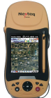
Nexteq Navigation, based in Calgary, Alberta, Canada, has announced the T5A, its new flagship multifunctional GNSS handheld data collector. The device is a high-accuracy GPS unit capable of 2-centimeter accuracy using real-time kinematic (RTK) and 50-centimeters globally using Nexteq’s i-PPP technology. With the T5A, users can achieve extremely accurate and consistent results anywhere in the world with no loss in flexibility, Nexteq said, adding that the unit’s centimeter-level precision coupled with versatility allows for accurate data collection in the most diverse weather conditions.
Suitable for projects in all-environments, the T5A has a professional quality internal GPS receiver that provides accurate real-time results. Using Nexteq’s Freedom, i-PPP, or RTK technologies, the T5A data collector can provide flexible and accurate positioning in all parts of the world, Nexteq Navigation said.
The T5A has a 3.7-inch color touchscreen that is both waterproof and dustproof. The device includes features such as Bluetooth, Wi-Fi, digital cellular data and voice, microSD card slots, and a 3.0 megapixel digital camera.
Like all Nexteq Navigation GPS handhelds, the T5A is a ruggedized and tough unit. The T5A has an IP66 rating with excellent dust and water resistance.
Hexagon AB announced it has acquired all shares in the Norwegian company My Virtual Reality Software AS (myVR).
According to the announcement, myVR provides software that offers a solution for 2D, 3D and 360-degree viewing for desktop and mobile. The company has developed a patented technology platform that enables high-resolution real-time viewing of interactive maps over networks with limited bandwidth. The platform makes it possible to view large-scale models on any 3D hardware-supported client platform, including mobile phones and tablets.
myVR 3D Map
"The acquisition of myVR will be of great value for Hexagon's current offerings. Everything is going mobile, including our customer offerings," said Ola Rollén, President and CEO, Hexagon AB. "In the past, the problem with displaying 3D data on a mobile device such as a tablet has been size limitations of data transfers, and also the ability to handle the transfer in a real-time environment. myVR has a unique solution to this problem, and Hexagon will make use of its technology in all of our divisions."
Founded in 2003, myVR provides real-time, 3D virtual technology to the Oil & Gas, Building & Construction, Government and Web Portals industries, as well as other traditional and emerging digital markets.
Hexagon announced that myVR will be fully consolidated as of today. The acquisition will not have any visible impact on Hexagon's earnings in the short-term.
Several new rugged GPS-enabled devices were announced this week.
Juniper Systems has partnered with Pennsylvania-based SDG Systems to market the Mesa Rugged Notepad with Android (AOSP) 2.3 operating system, a rugged handheld computer known as the RAMPAGE 6 and distributed through SDG Systems. Availability of the RAMPAGE 6 is scheduled for the third quarter of 2012 and its first public presentation will be at the Esri International User Conference in San Diego, July 23–27, 2012.
The Android (AOSP) 2.3 operating system on the RAMPAGE 6 offers many advantages for data collection, including easy multi-tasking, a modern user interface, rich programming environment, multi-platform development, abundant application data storage, open source flexibility, and the opportunity for a custom Android interface developed by SDG Systems, according to Juniper Systems. Additionally, its optional kiosk mode allows only certain applications to be accessible by the user, creating a single-purpose device without distractions, Juniper Systems said.
The RAMPAGE 6 will have the same features as the Mesa Rugged Notepad, including a large 5.7-inch viewing display, IP67 ingress protection rating for water and dust, integrated 2–5 meter GPS receiver, optional integration of a 1D/2D barcode scanner, and optional Class I, Division 2 certification for use in hazardous locations.
Meanwhile, DRS Technologies, Inc., announced today that its Tactical Systems division has expanded its product portfolio with three new ARMOR rugged tablets. The ARMOR X7et and the ARMOR X7ad are thin, lightweight tablets based on customers requesting even more portable computers from ARMOR, the company said. “The 7-inch multi-touch tablets shatter the perception of bulky, rugged computing, and offer field service workforces the ability to choose between the fast-growing Android OS and the enterprise-friendly Microsoft Windows platform,” The company said. Additionally, DRS is now offering a new light convertible tablet, the ARMOR X12kb, that meets MIL-STD-810G. All three follow introduction of the ARMOR X7 compact rugged tablet launched in 2011.
The ARMOR X7et is a Windows-based tablet that weighs less than 1.5 pounds and provides six hours of battery life. It features an Intel Atom Z670 processor and runs Microsoft Windows 7 Professional. Its Android counterpart, the ARMOR X7ad, weighs 1.3 pounds and operates for up to eight hours. It features a NVIDIA Tegra 2, 1.0-Ghz dual-core processor, and operates on Android v3.2. Both lightweight tablets feature a 7-inch outdoor-readable multi-touch screen display. They are certified to MIL-STD 810G for extremes in temperature, vibration, shock, and four-foot drops and have an IP65 rating for ingress protection, which means they are fully protected against dust and can withstand low pressure jets of water from all directions.
Weighing 5.5 pounds, the ARMOR X12kb features a 12.1-inch sunlight-readable swivel touchscreen that incorporates polarized LCD glass and anti-reflective technology. The ARMOR X12kb offers the Intel Core i5-560UMCPU processor and runs Microsoft Windows 7 Professional. It has a long battery life, operating for up to eight hours, as well as a spill-proof keyboard and touchpad. Additionally, the one-click stealth mode operation disables all emitting light and sounds, a feature designed for the unique applications of covert operations.
The three new ARMOR mobile computers include connectivity options including Gobi Wireless Broadband, integrated GPS, 802.11 b/g/n Wi-Fi, and Bluetooth wireless. They are designed to make it easier for workers to use mobile computing in rugged environments, as this product video shows:
Juniper Systems announced the Mesa Rugged Notepad with Android (AOSP) 2.3 operating system. In a partnership with Pennsylvania-based SDG Systems, the RAMPAGE 6 will be distributed exclusively through SDG Systems.
“Our new partnership with SDG Systems will further enhance our ability to provide the best rugged handheld computing solutions to our customers. By working together, we have created a very unique and in-demand handheld computer with the Android (AOSP) operating system, now known as the RAMPAGE 6,” said Rob Campbell, President and CEO of Juniper Systems. “Leveraging the Android expertise of SDG gives our customers an original and powerful data collection device and we couldn’t be more excited about the opportunities this new partnership will bring.”
According to the announcement, the Android (AOSP) 2.3 operating system on the RAMPAGE 6 offers many advantages for data collection, including easy multi-tasking, a modern user interface, rich programming environment, multi-platform development, abundant application data storage, open source flexibility, and the opportunity for a custom Android interface developed by SDG Systems. Additionally, its optional kiosk mode allows only certain applications to be accessible by the user, successfully creating a single-purpose device without distractions.
“SDG Systems is proud to develop and distribute the RAMPAGE 6 as our very first SDG-branded handheld computer. Collaborating with Juniper Systems on a product as unique and dependable as the Mesa Rugged Notepad has made this experience very rewarding and we’re excited to put the SDG name on it. Our decision to develop Android (AOSP) for the Mesa was based on its extreme ruggedness, quality design, and dependability. I am confident that the RAMPAGE 6 will live up to those standards,” said Todd Blumer, President and CEO of SDG Systems.
Juniper reports that the RAMPAGE 6 will feature the many advantages and benefits of the Mesa Rugged Notepad, including a large 5.7 inch viewing display, IP67 ingress protection rating for water and dust, integrated 2–5 meter GPS receiver, optional integration of a 1D/2D barcode scanner, and optional Class I, Division 2 certification for use in hazardous locations.
Availability of the RAMPAGE 6 is scheduled for the third quarter of 2012 and its first public presentation will be at the Esri International User Conference in San Diego, July 23–27, 2012.
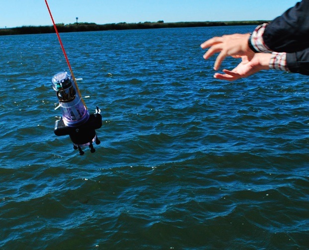
UC Berkeley researchers have developed a method to learn about the quality, volume, speed, and direction of the flow of salt walter and freshwater through the Sacramento Delta. (Photo courtesy of : University of California, Berkeley.)
Swarms of robots equipped with GPS and sensors were released May 9 into California rivers to measure water flow, salinty levels, and pollution, reports OurAmazingPlanet.com. The Floating Sensor Network is intended to change the way water quality and flows are monitored in the Sacramento-San Joaquin river system.
At the University of California, Berkeley, a group of 100 robots was released into the Sacramento River near Walnut Grove. About two thirds of California’s fresh water is in the river system, supplying about two-thirds of the state’s population with drinking water and irrigation. The initiative is led by associate professor Alexandre Bayen at the Center for Informatin Technology Research in the Interest of Society (CITRIS).
The robots each have a sensor to test salinity and a GPS unit from a smartphone. Some have propellers so they can maneuver around obstacles and reach specific destinations. The robots are also sending Tweets, to @fsnandroid61.
Watch Electrical Engineering Graduate Student, Andrew Tinka, describe the project:
Woolpert announced its Indianapolis office has been awarded two contracts totaling approximately $2 million by the City of Indianapolis Department of Public Works (DPW) to survey pavements and develop a street sign inventory using mobile mapping technology.
According to the announcement, the project requires collection of data across 3,200 miles of city streets, one of the single largest mobile light detection and ranging (LiDAR) collection efforts to date. LiDAR technology uses pulses from a laser to produce highly accurate measurements and map physical features.
“We’re proud to be at the front of using this industry-leading technology for a cost-effective approach to collecting data and developing a 3D model of the city. This truly maximizes taxpayers’ dollars by reducing the cost of a data collection effort while also providing us with the data necessary to perform government functions more efficiently, such as street rehabilitation,” said Jeremy Jobe, Woolpert project manager in Indianapolis. “Further, the dataset can be used for safety improvements through viewshed or line-of-sight analysis to proactively identify potential traffic hazards caused by the surrounding environment.”
Nearly half of the cost associated with the project is being covered through a federal grant, according to Woolpert. The city leveraged this grant to significantly reduce using local dollars for the project. Remaining funds were generated from the RebuildIndy program and other local funding sources.
Woolpert will use its Optech LYNX M1 Mobile LiDAR system to collect the data and then use that data to develop a street sign database for compliance with Federal Highway Administration’s (FHWA) Manual on Uniform Traffic Control Devices (MUTCD) requirements for sign inventories. This manual provides the U.S. standard for signs, signals and pavement markings.
“The benefit of using a high-accuracy mobile LiDAR system with survey-grade capabilities on such projects is the rich dataset that it captures from which assets can be extracted, in this case signage,” said Jobe. “The city will not only be able to use the data for its sign database, it will also be able to extract or call on the Woolpert team to extract additional features in the future without remobilizing the team and assuming associated costs or placing additional field crews in harm’s way, which provides the true value in this collection effort.”
Woolpert will team with VS Engineering and DB Engineering on the sign inventory and Dynatest on the pavement analysis. Upon completion of the project, data will be integrated with the city’s existing computerized maintenance management system.
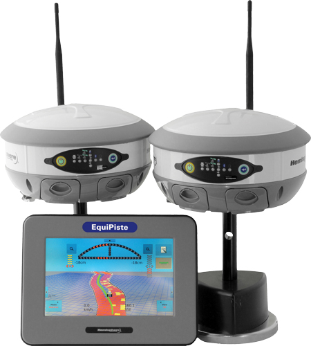
Hemisphere GPS has announced the EquiPiste integrated snow grooming management system. EquiPiste provides visual guidance, snow depth status, and event logging for snow grooming operators, mountain managers and snow road operations. Ski resorts benefit from improved grooming quality and productivity, optimal snow making decisions and distribution, as well as more predictable and preventative snow cat maintenance, according to Hemisphere GPS.
Snow grooming operations are tasked with creating quality snow conditions for ski trails or pistes, as they are referred to in the industry. Designed with an integrated touchscreen terminal and Crescent GPS, Hemisphere GPS’ EquiPiste graphically displays to the operator the areas groomed, boundaries, assets, points of interest, and hazards. Through the guidance cues, operators increase their efficiency and quality of work by avoiding overlaps and skips in grooming, Hemisphere GPS said. Areas that need attention such as thin snow pack and winch anchors can be flagged with meta-data so operators can easily navigate back at any time, even in low visibility. Pathways can be mapped and re-used for training novice operators or for repeatedly navigating snow roads. Operation managers benefit from reviewing the job files from each machine to determine variable costs, performance and maintenance tracking, the company said. As well, data can be mapped within Google Earth and used for generating daily grooming or road maintenance reports for customers.
Many ski resorts also spend a substantial amount of their budget on snow making activities. When combined with Hemisphere GPS’ survey grade Eclipse GNSS technology, EquiPiste displays and records real-time snow depth measurements and maps, the company said. The snow depth data improves the efficiency and quality of managing the snow levels. The depth data helps indicate where and when to make snow, it alerts the operator to thin snow pack, where to redistribute snow as well as how to identically recreate (day to day and year to year) downhill race courses. Analysis of the snow depth data enables more optimized snow management.
“Through collaboration with the ski resort and snow vehicle machine industry we have customized existing Hemisphere GPS technology to serve an adjacent vertical market,” said Andre Roberge, senior manager of New Ventures at Hemisphere GPS. “EquiPiste is truly a comprehensive snow management system that allows ski and snow road operations to capture and visualize the status and behaviour of snow for optimized grooming and manufacturing. Our customers have experienced tremendous benefits in productivity, quality, and safety as well as significantly reduced operational expenditures and lowered environmental impact. As a result, EquiPiste customers are able to provide a better standard of service and experience to their customers.”
Trimble announced that it has entered into a definitive agreement to acquire SketchUp, one of the most popular 3D modeling tools in the world, from Google. The transaction is expected to close in the second quarter of 2012, subject to customary closing conditions and expiration of the waiting period under the Hart-Scott-Rodino Antitrust Improvements Act. While financial terms are not being disclosed the transaction is not expected to be material to 2012 earnings per share.
According to the announcement, as part of the SketchUp platform, Trimble will also partner with Google on running and further developing SketchUp’s 3D Warehouse, an online repository where users can find, share, store and collaborate on 3D models. The site enables users to create collections of models, including 3D Buildings, and share them with fellow modelers around the world. Individual models can be loaded, saved and viewed in 3D from within SketchUp or a web browser. For the foreseeable future, Google will host and operate the 3D Warehouse for Trimble and together the companies will continue to offer the same capabilities, functions and services that are offered today. The ability for users to submit 3D Buildings for potential acceptance and viewing in Google Earth will be maintained. Currently the 3D Warehouse has almost two million user-generated models.
“SketchUp and the corresponding 3D Warehouse provide an important element of our long term strategy by enhancing the integration of our field presence with the wider enterprise,” said Bryn Fosburgh, Trimble vice president. “Trimble has already created the de-facto standard for field data models and project management tools for our key markets. SketchUp, together with these existing capabilities, will provide a stand-alone and enterprise solution that will enable an integrated and seamless workflow to reduce rework and improve productivity for the customer. Users will be able to collect data, design, model, and collaborate on one platform. The combined capability will enhance our ability to extend our existing market applications including the cadastral, heavy civil, and building and construction industries. In addition, the SketchUp platform will enable Trimble, third-party developers and our distribution partners to efficiently develop new applications.”
“Since its inception, the SketchUp team has been committed to providing a robust, user-centric solution to its community and we look forward to engaging their talent and expertise. Beyond extending the reach of the product into Trimble’s commercial markets, we are committed to continuing to provide SketchUp as a free version to millions of users. Trimble and Google will also continue to collaborate on utilizing other Google tools for Trimble’s markets that, along with SketchUp, will provide our customers innovative and productive tools that transform their work,” concluded Fosburgh.
“In Trimble, we found a partner that will grow SketchUp in a way that best supports the SketchUp team and our users,” said Brian McClendon, Google’s vice president of engineering. “While at Google, the SketchUp community grew significantly because the team put users first, and we are confident they will continue to do so at Trimble. We at Google look forward to a continued partnership with Trimble and the SketchUp team.”
Trimble reports that SketchUp will continue to support all of its current users through its Web site at: http://sketchup.google.com. Concurrently, the SketchUp engine will be integrated into Trimble’s current solutions in its Engineering and Construction, Field Solutions and Mobile Solutions segments.
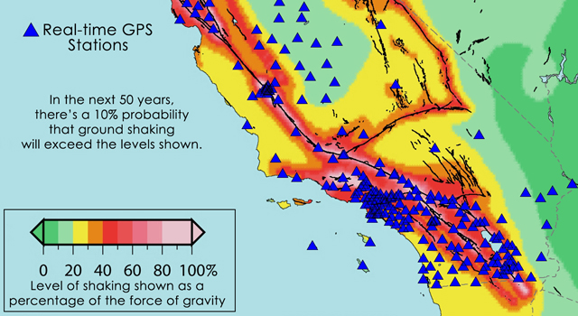
Location of the more than 500 real-time GPS monitoring stations in the western United States that make up the Real-Time Earthquake Analysis for Disaster Mitigation Network. Image credit: USGS/UC Berkeley/Scripps Institution of Oceanography.
The space-based technology that lets GPS-equipped motorists constantly update their precise location will undergo a major test of its ability to rapidly pinpoint the location and magnitude of strong earthquakes across the western United States, according to NASA. Results from the new Real-time Earthquake Analysis for Disaster (READI) Mitigation Network soon could be used to assist prompt disaster response and more accurate tsunami warnings.
The new research network builds on decades of technology development supported by the National Science Foundation, the Department of Defense, NASA and the U.S. Geological Survey (USGS). The network uses real-time GPS measurements from nearly 500 stations throughout California, Oregon and Washington. When a large earthquake is detected, GPS data are used to automatically calculate its vital characteristics, including location, magnitude and details about the fault rupture.
“With the READI network, we are enabling continued development of real-time GPS technologies to advance national and international early warning disaster systems,” said Craig Dobson, natural hazards program manager in the Earth Science Division at NASA Headquarters in Washington. “This prototype system is a significant step towards realizing the goal of providing Pacific basin-wide natural hazards capability around the Pacific ‘Ring of Fire.’”
Accurate and rapid identification of earthquakes of magnitude 6.0 and stronger is critical for disaster response and mitigation efforts, especially for tsunamis. Calculating the strength of a tsunami requires detailed knowledge of the size of the earthquake and associated ground movements. Acquiring this type of data for very large earthquakes is a challenge for traditional seismological instruments that measure ground shaking.
High-precision, second-by-second measurements of ground displacements using GPS have been shown to reduce the time needed to characterize large earthquakes and to increase the accuracy of subsequent tsunami predictions. After the capabilities of the network have been fully demonstrated, it is intended for use by appropriate natural hazard monitoring agencies. The USGS and the National Oceanic and Atmospheric Administration are responsible for detecting and issuing warnings on earthquakes and tsunamis, respectively.
“By using GPS to measure ground deformation from large earthquakes, we can reduce the time needed to locate and characterize the damage from large seismic events to several minutes,” said Yehuda Bock, director of the Scripps Institution of Oceanography’s Orbit and Permanent Array Center in La Jolla, Calif. “We now are poised to fully test the prototype system this year.”
The READI network is a collaboration of many institutions, including Scripps at the University of California in San Diego; Central Washington University in Ellensburg; the University of Nevada in Reno; California Institute of Technology/Jet Propulsion Laboratory in Pasadena; UNAVCO in Boulder, Colo.; and the University of California at Berkeley.
NASA, NSF, USGS and other federal, state and local partners support the GPS stations in the network, including the EarthScope Plate Boundary Observatory, the Pacific Northwest Geodetic Array, the Bay Area Regional Deformation Array and the California Real-Time Network.
“The relatively small investments in GPS-based natural hazards systems have revolutionized the way we view Earth and allowed us to develop this prototype system with great potential benefits for the infrastructure and population in earthquake-prone states in the western United States,” said Frank Webb, Earth Science Advanced Mission Concepts program manager at JPL.
The READI network is the outgrowth of nearly 25 years of U.S. government research efforts to develop the capabilities and applications of GPS technology. The GPS satellite system was created by the Department of Defense for military and ultimately civil positioning needs. NASA leveraged this investment by supporting development of a global GPS signal receiving network to improve the accuracy and utility of GPS positioning information. Today that capability provides real-time, pinpoint positioning and timing for a wide variety of uses, from agriculture to Earth exploration, NASA said.
“Conventional seismic networks have consistently struggled to rapidly identify the true size of great earthquakes during the last decade,” said Timothy Melbourne, director of the Central Washington University’s Pacific Northwest Geodetic Array. “This GPS system is more likely to provide accurate and rapid estimates of the location and amount of fault slip to fire, utility, medical and other first-response teams.”
The GPS earthquake detection capability was first demonstrated by NASA-supported research on a major 2004 Sumatra quake, conducted by Geoffrey Blewitt and colleagues at the University of Nevada in Reno.
At the Geospatial World Forum, TomTom announced the launch of its high volume batch geocoding web service. The TomTom Global Geocoder enables businesses to process large amounts of data with a single click of a button and return results quickly.
According to the announcement, geocoding is the process of converting addresses into geographic coordinates to allow location analysis. By combining geographic knowledge with business information, businesses can make smarter decisions that will lead to better products, as well as cost savings and process improvements. For example, insurance companies are relying on geocoding techniques to help set premiums and make underwriting decisions based on the physical locations of the insurance projects.
“Geocoding is part of TomTom’s DNA. With close to 30 years of experience developing global digital maps, TomTom is known for its expertise in geocoding,” said Dan Adams, Vice President, Location and Live Services at TomTom. “By launching our global batch geocoding web service, we are providing critical spatial data to fuel our customers’ analytic engines.”
The TomTom Global Geocoder offers the following benefits:
High volume results in one easy step, with no usage restrictions
International coverage enables one stop for all geocoding needs
Highly accurate, address point level matching
Fast results delivering hundreds of thousands of records per hour
Visit TomTom at Geospatial World Forum booth #19 in hall 10 to learn more about the TomTom Global Geocoder, as well as other products.
HydroSpatial announced it has released the first in a new series of marine mapping layers to sit within the new HydroSpatial 2 Product Family. Benefits include an enhanced data model, allowing for intuitive feature filtering; geo-processing and spatial analysis to create customised data outputs and map views using both real world and abstract feature types. Mapping is delivered in themed tiers with improved symbology, and licensed as a complete package, delivering an exceptional user experience in both desktop, and web GIS.
According to the announcement, SeaZone HydroSpatial Base provides users with a definitive worldwide marine reference map incorporating large-scale, authoritatively sourced, marine geographic datasets. The content is processed to form a continuous vector layer dataset, with a well structured and defined feature and attribute model, providing the best possible marine mapping experience. SeaZone HydroSpatial Base is ideal for use as a marine spatial planning aid and as a primary decision support tool. It has a global reach and is available for regions where content is captured to scales greater than or equal to 1:1,500,000. The feature attribution for SeaZone HydroSpatial Base is comprehensive and serves a wide range use scenarios. For the high end technical user, HydroSpatial Base performs well when interrogated by vigorous and complex geo-processing or spatial analysis in GIS. For less demanding requirements, HydroSpatial Base represents an excellent high-resolution selectable back-drop with flexible filtering and styling.
SeaZone reports that the HydroSpatial Base provides decision makers with accurate information to make effective decisions in the marine environment. SeaZone HydroSpatial Base was delivered as a result of an extensive consultation with our HydroSpatial customers about how they would like the product to evolve, the improvement content they needed and the prices they would like to pay. SeaZone acknowledges the support of EU Interreg IVB Bringing Land and Sea Together (BLAST) Project in developing and testing the HydroSpatial Base concept.
Trimble has introduced the ultra-rugged Trimble SPS985 GNSS Smart Antenna for performing high-accuracy construction site measurements. The new smart antenna is made of a specially developed alloy that combines unprecedented strength and durability into a compact form to withstand the daily abuse of construction work, Trimble said.
With its enhanced internal shock isolation, the SPS985 is suited for high-vibration use on an all-terrain vehicle (ATV) or supervisor truck. User-friendly features such as a quick release connector and smartphone configuration make it easy to deploy and use as a base station or rover, mounted on a range pole or truck roof, Trimble said. Advanced communications including Wi-Fi, Bluetooth, and optional wideband radio integrate the receiver into the connected construction site.
“The Trimble SPS985 was engineered to be the toughest, smallest and easiest to use GNSS receiver we’ve ever built,” said Chuck Maniscalco, director of engineering for Trimble. “We listened to customer feedback and built the housing 50 percent stronger than any previous Trimble antenna, because we wanted it to perform ideally under extreme conditions — such as being dropped, tossed in a truck bed, rained on and otherwise abused in the construction setting. Contractors will likely never treat their SPS985 antennas as harshly as the Trimble engineering team has, but we intended to take rugged GNSS to the next level and we certainly achieved that.”
When used as a rover, the SPS985 allows for maximum flexibility for use on a wide variety of site measurement tasks. For initial site reconnaissance, it can be deployed with satellite-delivered GNSS corrections without a base station. For higher accuracy site measurements, it can receive Real-Time Kinematic (RTK) corrections via the internal wideband radio, Wi-Fi or the Internet.
An SPS985 unit can be easily moved from carrying case to range pole, tripod, t-bar, or vehicle with a single click — making it faster to begin working and allowing for more flexibility of operation techniques. For example, a grade checker can mount the SPS985 to an ATV and easily conduct site topos, check as-builts and verify road centerlines where it is not easy or safe to walk with a range pole. Extending its productivity, the same unit can then be mounted on the roof of a supervisor’s truck roof to collect and manage progress data.
As a base station, the SPS985 incorporates Wi-Fi communications for small site projects and optional wideband radio for long-range operations on large projects. Designed for ease of use, it will automatically establish a radio or Wi-Fi connection and transmit RTK corrections to another rover or machine control system, Trimble said. Construction crews can spend more time doing the work and less time setting up and maintaining the equipment.
As a component of the Trimble Connected Site solutions portfolio, the SPS985 also offers connectivity features that save administrative time and increase working productivity. When used with a Connected Controller such as the Trimble TSC3 or Trimble Tablet, job crews can connect to a mobile hotspot in the site trailer or supervisor’s truck and receive GNSS corrections via VRS network or Trimble Internet Base Station (IBSS). They can also save considerable time by wirelessly synchronizing progress data and as-built information to the job supervisor or head office and receiving updated design information back without ever leaving the job site.
Quick start technology and the ability to set up and configure the receiver using a smartphone increases flexibility and eliminates the need to use a more expensive controller for daily setup. The Trimble Web UI is optimized for small screen devices, allowing a GNSS manager to monitor base station performance, availability and configuration without visiting the job site to set up each day.
The new Trimble SPS985 GNSS Smart Antenna is available now through Trimble’s worldwide SITECH Technology Dealer Channel.