Altus is a California-based business that has made an impact with innovative, high-performance products in a market that didn’t seem to have room for a new entrant. The technology, innovation, and product-marketing approaches that Altus has used appears to have made a real impact and provided a number of customers with a new outlook on their survey tools.
In today’s GNSS marketplace, a small company in almost any sector, especially in the survey market, generally has to contend with incumbents, or larger companies who have already made their mark, become widely associated with business in that sector, and who may even dominate through wide product offerings and extensive worldwide distribution systems. The survey/geomatics sector has gone through a lot of consolidation as smaller players, their products and technologies have been absorbed. As one of the very first GNSS application specialization areas, the length of time this market has been evolving has probably also been the longest. So the larger, more established companies have got their alliances and distribution systems as tuned up as their products, and getting new products to market can be somewhat easier for them than for a new comer.
So how does a new entrant compete and succeed? Well, smaller companies are generally more nimble and responsive, and their product offering is probably more adaptable early on in their launch phase. And new entrants can usually find technological advantages over their more established competitors, which allows them to capture those early sales. But getting the product to the customer is much more difficult without a well-established distribution system. Smaller companies may be spending significant effort finding those key deals and dealers that get them off the launch pad — sometimes this step can seem like as much effort as getting the product developed and market ready!
But the smaller companies may also try harder with accessible, easy-to-contact customer service people who quickly provide innovative solutions, stretch to provide loaner equipment, and send people out in the field to touch, feel, and empathize with the customer’s application. Not that the big companies don’t also try hard, and they clearly have great products to work with, but the smaller guys do seem to come up with more innovative approaches, simply because their survival and subsequent healthy growth depends on it. And the guys back in engineering will jump through hoops for you and come up with rapid solutions because everyone in a small company knows how important those initial sales can be, and how essential it is to establish their reputation for success.
So, when I first came across Altus a couple of years ago, I must admit that the thought of another small start-up trying to penetrate the survey market was something I didn’t expect to work out. After all, Leica, Topcon, and Trimble seem to have all the right products, capabilities and market presence that all the customers in this market might ever need. But Altus is not only still around, it is also thriving and generating growth after more than six years in the business.
So you have to ask yourself, “How come?” What magical recipe have these guys discovered that has allowed them to be successful? I thought it would be worth looking at their business model, who’s behind it, and the technology that has allowed them to do this.
The pedigree of the company is what strikes you up front — a seasoned team, drawn from most of the industry leaders, who have learned from the school of hard knocks just what works and what doesn’t. A small group of people, but an experience base that is right up there. Ex-Leica, NovAtel, Ashtech, Magnavox, Trimble, and Thales people who have worked in some of the best companies in the GNSS world and acquired best-practices and touched some of the best technology there is to be had. It figures that this team would find a different approach, which has allowed them to create a niche inside a business dominated by the big guys. Lead by CEO Neil Vancans, this team of professionals looks set to continue their fight for a share in the survey market.
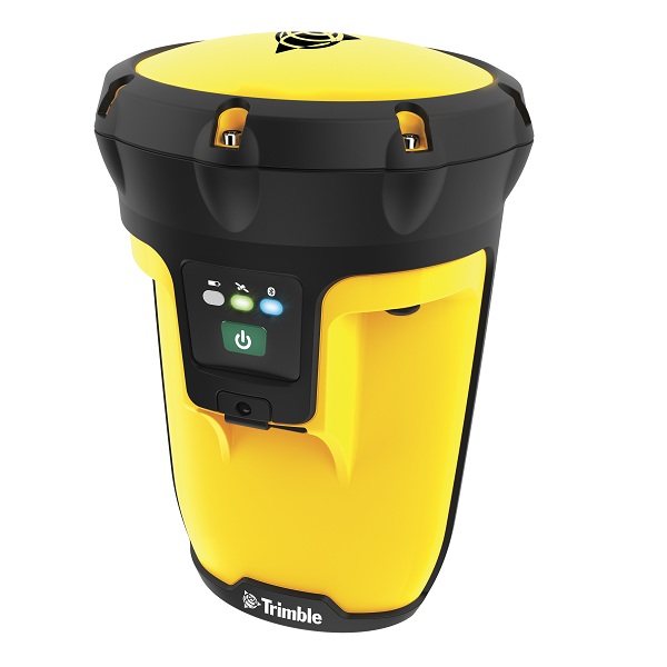
The principle product that Altus has supplied to this market is the APS-3 integrated receiver/antenna, which includes dual-frequency GPS/GLONASS/SBAS, integrated GSM modem, UHF radio, Bluetooth, removable SD data card, and dual lithium-ion “hot-swap” batteries. Altus makes and assembles this self-contained, integrated unit and was one of the first to market with an affordable single-unit integrated receiver. Now others have appeared in the marketplace, so it’s clear the Altus approach was right for the industry. The core GNSS receiver is supplied by Septentrio, who is also a part-owner in the company — so Galileo could be added as an option in the future.
Altus APS-3 integrated receiver.
The formula that Altus is working with involves providing an open platform that can be integrated with a number of different components, rather than locking customers into a complete package and imposing a pre-defined workflow approach. Customers can mix and match software, and interface with other controllers and instruments (such as total stations), and also establish their own way of working. So the critical issue in the Altus architecture is openness and the ability to allow users to make choices based on what they think is best for them, or what is best economically because they already have an existing investment in equipment. In the process, Altus is also sharing risks and development costs with collaborative companies who are also very good at what they do.
Given that the core receiver technology within the current receiver is supplied by Septentrio, it’s easy to understand why Septentrio has taken a part-ownership position in Altus. The Septentrio product line includes largely high-precision, survey quality, professional receivers — so a share in the interests of Altus also benefits Septentrio. Clearly Septentrio continues to invest and develop new capabilities and features for its own markets and customers, so receiver growth capabilities will be available to Altus going forward without the need to develop them in-house. The relationship with Altus is a close one, so it’s not surprising that Altus also directly contributes to Septentrio receiver feature definition and testing. Altus has actively participated in design of the RTK system, largely initiating and testing changes in the structure that more readily accommodate surveying user needs and in the design of the receiver. Altus is not just reselling a packaged OEM receiver — Altus staff have an intimacy with the receiver that affords a higher level of support to clients, and it is the support that Altus provides that has enabled them to successfully carve their niche.
A survey system has to include control and processing software, and Altus has chosen to include software supplied by Carlson who are reputedly the industry leader in third-party, off-the-shelf survey software. For Altus, Carlson provides the greatest efficiencies to the user for any field surveying software and it is without any tie to any major manufacturer, which otherwise could have a negative impact on Altus market penetration. Carlson’s professional integration of the APS-3 into their software suite created a very fast and simple user interface. Carlson were instrumental in building a complete system in the early days and Altus’ success is founded on their professionalism. Carlson shares the open-architecture approach and because of this has also has enjoyed great success. In keeping with their open architecture approach, Altus also works closely with MicroSurvey and other partners
But how you control the APS-3 and collect data doesn’t seem to have gone the traditional route of having a dedicated ‘controller’ as such. IS departments nowadays seem to decide which PDA people in the field will use, so its a natural step to simply develop your own App and provide that to users to run on their own hand-held device. Because of the proliferation of devices out there, Altus’ contract software team has grown over time, and the future may bring more of the processing capability in-house as a consequence.
Altus has also integrated the APS-3 with IkeGPS, a unique device supplied by New Zealand-based Surveylab. Used stand-alone, the Ike uses a calibrated camera and digital compass for GIS data gathering. When integrated with the APS-3, more accurate measurements are available, while also acting as a controller for the APS-3. Likewise, APS-3 users can also benefit from the efficiency of using two sensor systems and one controller.
IkeGPS mobile GIS handheld.
Then you have to get it to market, so Altus has found a few dozen distributors around the world and a few niches that they fit right into. The major players in geomatics/survey inevitably part ways with pieces of their own distribution system over time, and personal relationships play the largest part of which sales outlet in which countries will work best with whom. So an entrepreneurial outfit looking for friends in the marketplace can often meet up with old acquaintances and provide key product features other’s might not have yet put in place in their product lines. So Altus’ successes in Canada and Germany have grown out of having the right product and right people on the ground at the right time. Customers in Australia, South Africa and Russia have also joined the fold of Altus users, as a result of close attention to local needs and access to the customer. In China, an OEM relationship with local assembly has allowed Altus to make inroads where market access is becoming more difficult for these types of products.
So what’s next? How does Altus expect to maintain growth? Well obviously new products are in the works, not only internally, but also through developments their partners have underway. Vancans feels that the GIS market is also moving up a step and wants survey quality accuracy. So he sees a major push into Utilities, Forestry, and other asset management-hungry fields. Tailored solutions like seismic surveying in the Canadian oil-patch and Forensic applications like an innovative evidence recorder used by the Royal Canadian Mounted Police (RCMP) – these are typical niches where customers have found it best to work with a small, very responsive outfit. More rugged survey solutions will allow Altus to bring survey-quality accuracy to utilities, in-shore dredging, off-shore oil-rigs, machine control and other users who want better location accuracy.
Extremely reliable dual frequency, dual constellation GPS/GLONASS RTK is a key component to this move up to higher accuracy, and Septentrio is supplying this capability. And for machine control applications there are versions where dual antenna solutions and dual receiver input processing is available. Where base-stations and radios just won’t work, its expected that L-band services will soon add incremental capability.
This GNSS business sector is still growing, so its good to see a smaller competitor with US manufacturing and technical service center located in Torrance also able to make a place for themselves with innovative products and approaches.
Tony Murfin
GNSS Aerospace


 Join GPS World’s Survey and GIS Editor Eric Gakstatter March 15 for the webinar, “Everything Else but GPS: How GLONASS, Galileo, and Compass Will Affect High-Precision Users.” The webinar will be held at 10 a.m. Pacific (1 p.m. ET/6 pm. GMT);