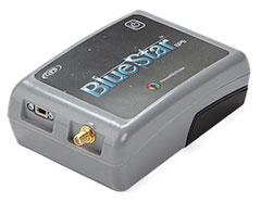
BlueStarGPS offers both GPS and GNSS options in a rugged, lightweight package. The BlueStarGPS device was designed to meet sub-meter mapping and data collection needs in the pipeline and utility industries. It provides sub-meter precision without post-processing, and maintains accurate positioning when the SBAS signal is obstructed. This means it can function under trees, around buildings and in rugged terrain where other receivers can fail.
The BlueStarGPS is designed specifically for use with Android mobile devices, such as smartphones, tablets or notebook computers, as well as cable and pipe “locating” tools with a connectivity range of up to 1 kilometer.
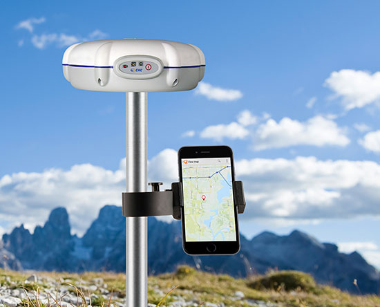
The X20i GNSS receiver by CHC Navigation pairs with iOS devices.
The X20i L1 GPS receiver by CHC Navigation is powered by a high-precision L1 GPS engine. Its integrated Bluetooth chip enables it to wirelessly collect submeter positions in real time or centimeter post-processed on an iPhone or iPad.
All location-aware apps on the iPhone and iPad are compatible with the X20i. Immediately after pairing and answering the security question allowing the X20i to take control of location services on the iOS device, 1 million iOS applications are capable of utilizing the high-accuracy data of the X20i, and become accurate to either 1 foot or 1 centimeter. Apps that can make use of the high accuracy include TerraGo Edge, ESRI’s ArcView Connector, and those by CarteGraph Systems.
Chip simplifies integration of GNSS into low-cost products
The Broadcom BCM47748 chip for the Internet of Things and wearables enables devices such as fitness bands to deliver pinpoint location while consuming minimal power and in some cases can eliminate the need for a separate microcontroller. The BCM47748 removes a bulk of the signal processing from the device MCU by calculating position, velocity and time on-chip, delivering significant system power savings. The chip uses intelligent firmware to extend battery life while maintaining accuracy in speed, distance and position. By absorbing location computations on-chip, Broadcom not only reduces power consumption but can also dramatically lower costs for OEMs by replacing the device MCU and reducing board space. Firmware inside the BCM47748 automatically adapts to user activity and context, whether biking, walking or running, to provide precise location results to the user, enabling performance that is not sacrificed for power savings.
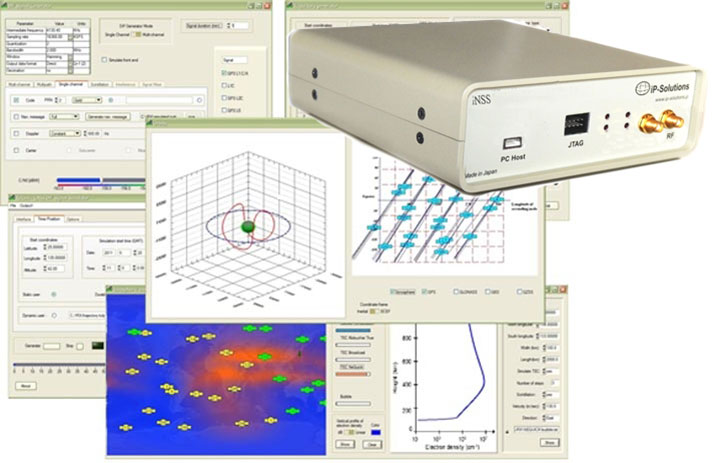
Simulation through real-time generation of GNSS signals
The upgraded ReGen DIF simulator is a high-end, low-cost 24-channel GNSS multi-frequency RF simulation solution for academia and research and development. The Replicator provides users with GNSS simulation through real-time generation of GNSS signals; the recording and playback of dual-frequency GNSS RF signals; and GNSS RF signal analysis with the JAXA COSMODE ionospheric scintillation monitor. Features of the replicator support various combinations of GPS L1, L2; GLONASS L1,L2,L3; BeiDou B1, B2; and Galileo E1 signals, and include ANSI C API for user access to customizable signal propagation, orbital, multipath, spatially correlated, scintillation and other error models.
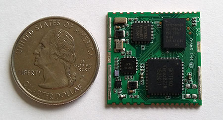
Designed for unmanned aerial systems and mobile platforms
The S2525F8-BD-RTK is a low-power, single-frequency RTK receiver with centimeter-level position accuracy. It supports GPS, BDS, QZSS and SBAS, simultaneously tracking up to 28 satellites. With its 25 x 25 millimeter form factor, 300-mW power consumption and 3 gram weight, it is designed for any outdoor applications requiring high-precision RTK positioning. S2525F8-BD-RTK supports both base station and rover modes. As a rover, it receives RTCM 3.0 or 3.1 data from a base station, or raw measurements from another S2525F8-BD-RTK receiver serving as base station, and performs carrier phase RTK processing to achieve relative positioning with 1 cm + 1 ppm position accuracy within 10-Km baseline.
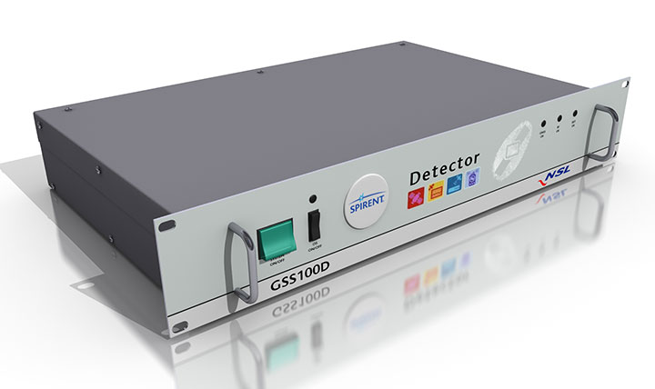
Spirent robust framework evaluates threats to GNSS
The GSS100D Detector is key to a robust PNT test framework to evaluate GPS and GNSS security vulnerabilities for position, navigation and timing systems. The framework will be used by technology, system and application developers where PNT is critical. The framework enables threats to be detected in the field, taken into the lab, and re-synthesized along with GPS and other GNSS signals. Spirent’s threat intelligence library of actual and typical threats provides a wide range of GNSS segment errors and spoofing attacks, as well as space weather and other vulnerabilities for preventive troubleshooting. Developed in collaboration with Nottingham Scientific Ltd., the GSS100D Detector enables detection, characterization and analysis of real GNSS threats.
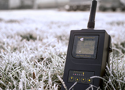
Priate radio data system for measurement applications
Compact-Proof is a UHF radio modem for wireless data transfer with a rechargeable battery, providing a compact and flexible solution for a wide range of applications, including land surveying under varying weather conditions. It supports the radio protocols of Pacific Crest, Trimble and other GNSS providers. It has a temperature range of -30°C to +65°C and frequency ranges of 330 MHz…420 MHz and 403 MHz…473 MHz. Its casing and connectors are rated IP67, making it waterproof and secured against dust. With transmitting power of 1,000 mW, it can be operated fully autonomously for more than 15 hours as a repeater station in the field.
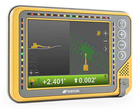
Base station or rover survey receiver with 864 channels
The all-in-one TRIUMPH-LS combines a high-performance 864-channel GNSS receiver, all-frequency GNSS antenna, and a modern featured handheld. The 864 all-in-view channels include Galileo E1/E5A/E5B, GPS L1/L2/L5, GLONASS L1/L2/L3, QZSS L1/L2/L5, BeiDou B1/B2 and SBAS L1/L5. The TRIUMPH-LS offers GUIDE data collection, Visual Stake Out (VSO), navigation, six parallel RTK engines, more than 3,000 coordinate conversions, advanced CoGo features, and rich attribute tagging on a high-resolution, bright, 800 x 460 bright display. Two 3-megapixel cameras enable recording of images along with GNSS data.More than 100 channels are dedicated to continuous interference monitoring. The Triumph-LS monitors and reports interference graphically and numerically with patent-pending interference protection. Interference awareness allows safe GNSS operation in city, airport and military environments. The unit can serve as base or rover. It has a GSM modem, UHF transmit and receive, and an internal high-performance geodetic antenna. The TRIUMPH-LS automatically updates all firmware when connected to a Wi-Fi Internet connection.
The Trimble Indoor Mobile Mapping Solution (TIMMS) produces fast and accurate maps of difficult-to-navigate indoor spaces and translates them directly into 2D and 3D models of structured interiors. TIMMS 2 is a fusion of technologies for capturing spatial data of indoor and other GNSS denied areas, providing both lidar and spherical video and enabling the creation of accurate, real-life representations of interior spaces and all of their contents. The maps are geo-located; the real world positions of each area of the building and its contents are known and can be easily placed and oriented in a wide area model. Small and lightweight, TIMMS 2 can negotiate tight corners, closets and catwalks, and can be carried up and down staircases where no elevator is available for travel between building levels.
The new Leica Geosystems Pegasus backpack wearable mobile mapping solution.
Wearable reality capture
Portable backpack allows mapping while walking
The Leica Pegasus:Backpack is a wearable reality-capture technology that combines five high-dynamic cameras and two LiDAR profilers within an ultra-light and ergonomic carbon-fiber chassis. The ergonomic mobile mapper creates a 3D view indoors or outdoors for engineering or professional documentation while using SLAM (simultaneous localization and mapping) to determine position in GNSS-denied areas. With its fast and efficient capture, calibrated images and point clouds are quickly generated for applications as diverse as BIM 6D to industrial training and disaster analysis.
The YellowScan is a lightweight lidar designed for fixed or rotary-wing UAVs. It has an embedded Ellipse-E, a miniature inertial navigation system from SBG Systems, which helps obtaining a clear and accurate point cloud. YellowScan is operational at up to 75 meters and delivers a highly dense point cloud. It includes a lidar with a ±50 degree angle that measures 40,000 points per second, an Ellipse-E inertial navigation system coupled with a centimeter-level RTK GPS, an on-board computer and an integrated battery. LED lights provide useful information, such as whether the GPS is receiving RTK corrections.
The DJI GO app is an upgrade to the previous DJI Pilot app with a redesigned user interface to make it easier to capture and share images with DJI’s Phantom 3, Inspire 1 and Matrice 100 UAVs. The app includes expanded in-app editing tools to make it easier to adjust photos and videos before uploading to social networks. DJI Director, which automatically edits the best moments from flights into short videos, has also been upgraded to include video speed control, additional templates and background music options.
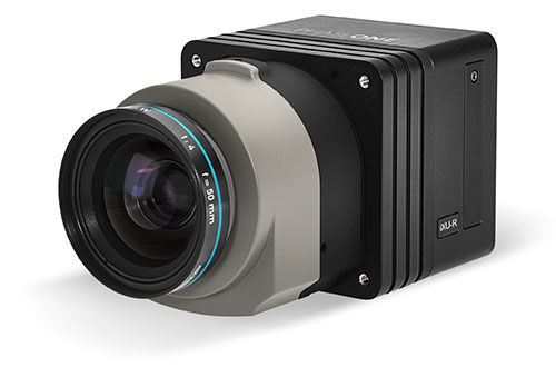
Lightweight with the resolution of a medium format system
The iXU-R camera series for UAVs is available in 80 MP, 60 MP and 60 MP achromatic versions. The cameras feature dedicated interchangeable 40-mm, 50-mm and 70-mm Phase One Rodenstock lenses equipped with central leaf shutters that can be quickly changed in the field, offering flexibility in aerial applications. The Phase One iXU-R systems have been designed to address the aerial data acquisition market’s needs with high-performance optics, flexibility to fit into small places and Phase One’s fastest 80 MP platform. Phase One aerial cameras offer direct communication with GPS/IMU systems and the ability to write data to the image files.
The Aeryon SkyRanger introduces a new airframe and integrated system design to its Aeryon sUAS (small UAS) platform, based on thousands of hours of flight time and successful customer exercises and missions around the world. The SkyRanger is suited for both land and maritime applications, and is designed to military and government specifications for immediate aerial intelligence gathering. Vertical Take-Off and Landing (VTOL) enables continuous eyes-on-target, operations in confined or hard-to-reach environments, and low-risk launch and retrieval without peripheral equipment. Features include up to 50-minute flight time, single operator transport and deployment with no launch or recovery equipment, reliable flight performance in demanding environments such as high winds, and an intuitive touchscreen interface. Microsoft has chosen the SkyRanger to demonstrate aerial image and data capture for its new Microsoft Advanced Patrol Platform (MAPP) vehicle.
Trimble has acquired privately held Telog Instruments Inc., based in Victor, New York. Telog is a wireless water infrastructure monitoring and management company. The acquisition extends Trimble’s smart water strategy by adding advanced water management technology and productivity solutions to the company’s portfolio. Financial terms were not disclosed.
Telog, founded in 1984, manufactures a suite of wireless remote monitoring, analytics and data acquisition systems that are used by thousands of water, wastewater and stormwater management utilities and private contractors throughout North America. Its Telogers family of battery-powered, environmentally rugged wireless monitors provide an automated means of collecting, archiving, presenting and sharing data from a wide variety of remote assets such as flowmeters, rain gauges, surcharge sensors, pre-treatment water quality sensors, lift stations and pressure sensors.
Applications for Telog solutions include remote monitoring of flow rates, reservoir and tank levels, water quality, well and groundwater levels, pump station performance, hydrant and valve pressure and sewer overflows. The solutions can also be combined with automated metering infrastructure to provide smart water networks that improve sustainability and water conservation and reduce leakage and non-revenue water. Customers can benefit through improved drinking water quality, lower water loss and leakage, reduced wastewater and stormwater overflows and spills, and enhanced regulatory compliance.
“Trimble remains focused on offering industry leading technology solutions for the water industry,” said Marcus McCarthy, general manager for Trimble’s Water Division. “The acquisition of Telog enables us to expand our portfolio of hardware and software products with industry leading real-time wireless sensors and monitoring solutions. The management of data in real time will provide value to customers facing a growing number of water supply, environmental and regulatory challenges.”
“We are very excited to join Trimble,” said Barry Ceci, founder, president and CEO of Telog. “In addition to the continued focus on supporting our current customers and our core North American market, the acquisition will enable us to grow Telog’s suite of products and expand our global footprint. This is an exciting time for Telog and our customers, who can also benefit from Trimble’s comprehensive portfolio of smart water management solutions.”
I was born in a small town and I live in a small town. I’ll probably die in a small town, but only if you want to call a blue-collar city of 75,000 people small. My friends are small town and my parents still live here in this same small town. It was here in this small town that I started my career as a surveyor and circled back for an opportunity to be near family and friends.
There are many towns, villages and cities in the Midwest that fit this description — mostly because of the agricultural background, but also because of the labor-intensive industries that provide most of the local jobs. Like those who prefer the large city hustle-bustle lifestyle, the small town attitude is the same, but in the opposite direction.
My career as a surveyor has provided me with opportunities to work in both small and heavily populated areas. I have seen the definite distinction between the two environments, and have seen many of the technological advancements of the past few decades. Having worked in both the large urban multi-discipline engineering firm and the small town surveying firm, I see much disparity between how surveying is done today from varying firms. The biggest difference I see today is how surveyors are using GPS technology for their field operations.
For the modern surveyor, GPS has become an everyday tool for measuring and data collection, but it wasn’t always that way. I began my career in the early 1980s working for a seven-person engineering firm in my small town, so GPS was never in our budget. Like most surveyors, I read about GPS use in technical publications, and was amazed what these magical boxes could do. The first generations of static receivers produced were very complicated and expensive. With long occupation times and even longer processing times, only the few companies who could afford the high-priced equipment and software were buying these units. Our small-town market could not justify this purchase, so we made do with conventional equipment as the norm.
Today’s environment requires the working knowledge of handheld data collectors that are more powerful than the computer on the Apollo moon mission, laser scanners that collect millions of points per second, and GPS receivers that talk through cell phones to get sub-centimeter accuracy. Around the corner is wider use of lidar data collection as well as the unlimited use and application of UAVs with cameras and scanners, so there is no end in sight for technology and the surveyor.
Most of the larger urban firms have established equipment and training budgets stay current with technology and not lose ground with the competition. Because of these strategic and spending plans, fee structures have increased over the years, and thus the cost of surveying has increased accordingly. This has also afforded those who stay up-to-date with current technology to push the limits of the equipment, and to continue to find new and useful ways to perform our work and provide newer services.
By keeping their costs down, small-town and rural surveyors have kept their fees down as well, but to the detriment of the profession. In fact, the cost of a typical land survey in a small town has come nowhere close to inflation for the past 40 years in most places.
In comparison, however, many industry partners of the surveyor have spent a great deal of money and time staying current with technology and production methods. Excavators and earth movers now have GPS-based computers controlling their movement and placement of material, as well as utilizing robotic instruments and GPS for layout of improvements and utilities. Architects and structural engineers are utilizing scanners for building and piping as-builts for existing and future improvements. Almost all farmers have tractors equipped with GPS-based control systems to help them plant and harvest with pinpoint accuracy, as well as apply herbicides or pesticides based upon high-tech mapping performed by crop analysts. Many land-management companies are gearing up with UAV technology to assist future operations with the information gathered by these flying wonders. Everyone around us is tech savvy, but the small surveyor seems to lag behind.
I wanted to be exposed to new technology when I moved from a small town to a large urban city in 1998. The big improvement for the surveying community was the introduction of real-time kinematic (RTK) methods. The firm I worked for during the late 1990s and early 2000s had been using RTK systems since their introduction. Being able to collect points “on the fly” both manually and with ATVs greatly increased our productivity as well as accuracy.
By the mid-2000s, almost every big-city firm utilized this technology as standard equipment for their crews. The only drawback to the RTK system was the need to leave a base-station receiver, so the introduction of the real-time network via cellphones in large market areas was another step in solidifying GPS use for everyday work.
Another benefit of extensive GPS use in the large city area is that most of the firms keep their surveys on state plane coordinate systems, so exchange and verification of data is a much easier process. These larger urban firms also continue to upgrade to newer equipment as more satellite systems are introduced. The addition of GLONASS has increased our precision and coverage levels, with future systems including Galileo, IRNSS and BeiDou set to raise that bar even higher.
On the contrary, many firms in small-town and rural areas have not progressed into new technologies because of cost and lack of cellular coverage needed for RTN systems. I moved back to my small town several years ago and have experienced this slip in technology firsthand. The big cellular carriers say they have 3G and 4G service in most places, but I can tell you from my travels that there are many places I have not been able to use our RTN receiver because of lack of cell signal. Most of the surveyors in our area still utilize an RTK system and will establish a position through OPUS or will assume a local coordinate system. Not many have upgraded their equipment to take advantage of GLONASS, so there are several steps they will need to take in the future to catch up to the industry. We also must travel greater lengths to recover NGS monuments for our positional verification, which will become more important as static monuments become a thing of the past.
So with my apologies to Mr. Mellencamp, my job as a surveyor has not been just small town, and has provided me with many big-city opportunities. Our crews face challenges here every day that many take for granted while in the big city market, including RTN coverage, GLONASS constellation usage and many more NGS monuments for QA/QC. Having more of these items could greatly help our productivity, especially when stronger cellular coverage is expanded to more of our rural areas.
I look forward to these improvements but will continue to work with our existing systems until that time. So look for us, surveying on in our small towns and locating all those little pink houses.
This column introduces Tim Burch, GPS World’s new co-contributing editor for survey. Tim will alternate with Dave Zilkoski in contributing monthly columns to the Survey Scene e-newsletter. Tim is survey department manager for Chastain & Associates LLC in the Decatur, Ill., area. He has been working as a professional land surveyor since 1985, and is the secretary, Board of Directors, National Society of Professional Surveyors.
For his next column in January, Tim plans to write about farmers and their technology in his area, focusing of course on GPS use. His article will compare surveyors’ processes with those used by farmers. (For Dave Zilkoski’s last column in October, see Establishing Orthometric Heights Using GNSS — Part 3.)
Topcon’s GX-55 control box for machine-controlled excavation.
Topcon Positioning’s GX-55 control box for machine-controlled excavation is now available in the Americas. With the release of the GX-55, Topcon adds three new 2D and 3D systems to its line of excavation solutions — the X-52 as well as the X-53 and X-53i. In any solution, the GX-55 is designed to provide users with new visual and audible features to achieve grade safely and efficiently for 2D or 3D excavating tasks.
“The bright and robust GX-55 delivers the highest quality graphical experience for modern machine control,” said Kris Maas, director of construction product management. “Today operators use Sitelink3D to instantly communicate entire job activities to managers on-the-go. The GX-55 delivers this real-time project information faster than ever.”
“Whether you want to take advantage of Topcon 2D, 3D or 3D indicate machine controlled excavation systems, the new GX-55 is delivered in a lightweight package for easy machine transfer, storage, and quick cable attachment,” Maas said.
The large 6.5-inch sunlight-viewable and color LCD touchscreen is surrounded by integrated LED light bars for a continuous grade reference of the bucket’s teeth. Additional features include customizable audible tones for grade reference, integrated virus protection, and easy-access USB ports for saving and downloading job files, Topcon said.
Update the Options Authorization File (OAF) of your base station.
Update the firmware of your UHF radio.
Configure the UHF radio parameters and start the base station.
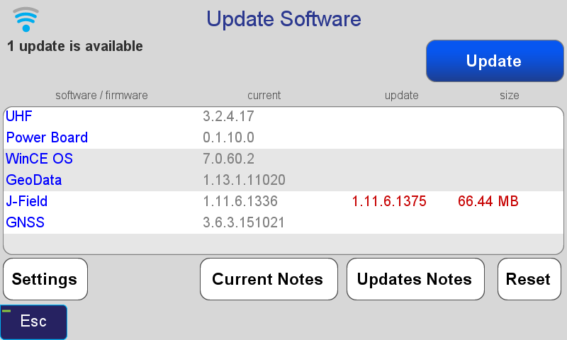
Update the TRIUMPH-LS Firmware and Software.
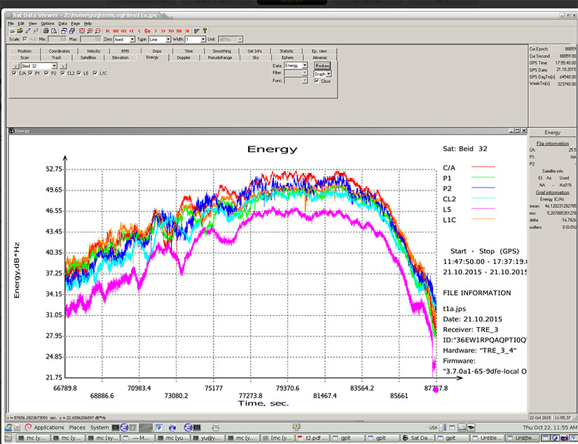
The first step is to update the TRIUMPH-LS to the latest software and firmware. Javad provides all software and firmware updates free of charge. Updates can be easily downloaded and installed when the TRIUMPH-LS is connected to the Internet through Wi-Fi or with a network LAN cable. Press the Support button found on the home screen and then choose Software Updates to search for updates. If updates are found, press Update to download and install the updates.
Update Software screen showing that an update of J-Field is available.
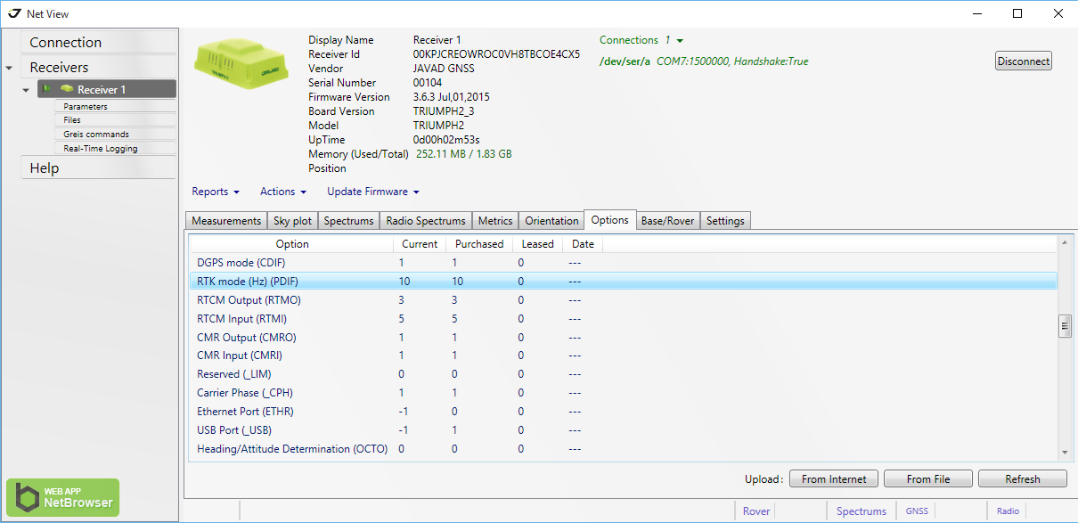
Update the Options Authorization File (OAF) of your base station.
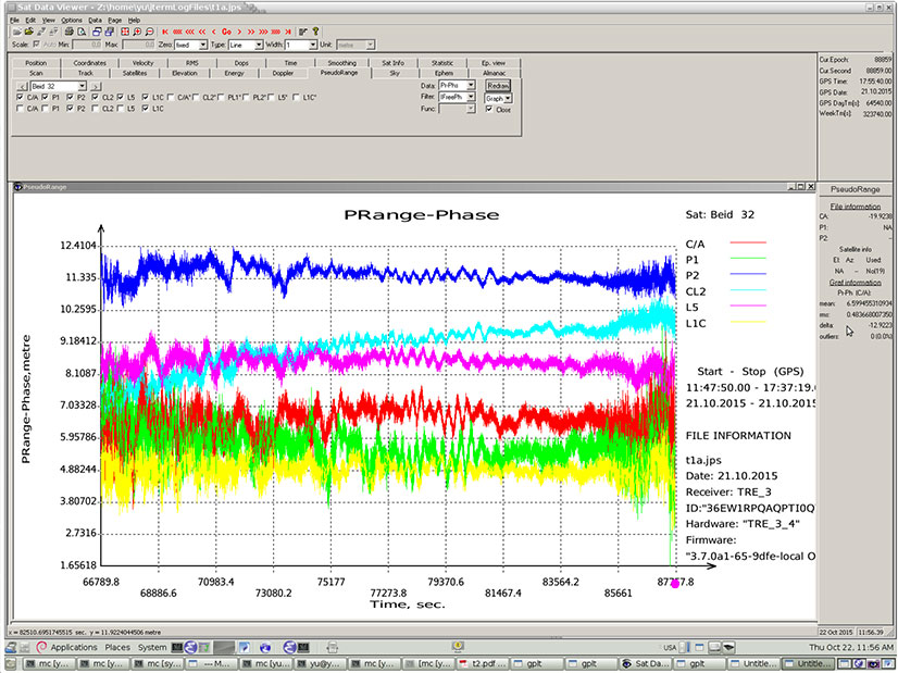
The next step is to check and update the OAF of your base station. Connect your base station to your PC with a USB cable and connect to it through NetView. Navigate to the Options tab in NetView and check to see if your receiver has the “RTK mode (Hz)” option of 10.
NetView Option tab showing the RTK mode (Hz) option has a value of 10.
If you do not have this option, press the Upload “From Internet” button to update your options. JAVAD GNSS is giving this option free of charge to all users who have purchased an RTK receiver.
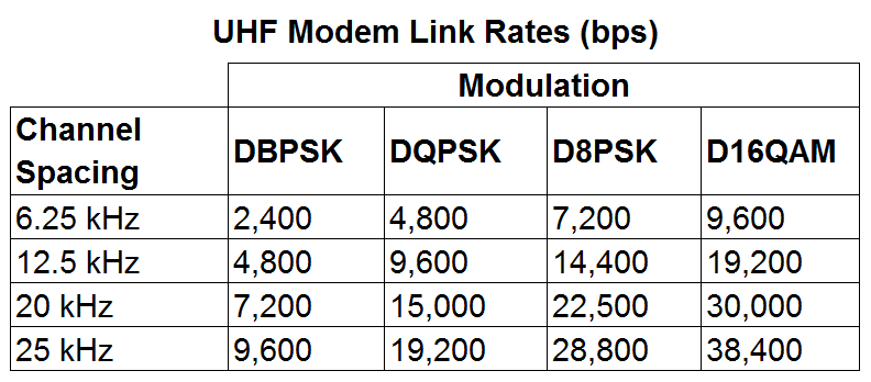
Update the Firmware of Your UHF Radio.
A recent update is needed for the UHF radios to work when a call sign is being broadcast with corrections rates faster than 1 Hz. Download the latest firmware from http://javad.com/jgnss/support/update.html and follow the instructions on this page to install this firmware. When launching ModemVU on your PC, be sure to right click on it and choose “Run as administrator”.
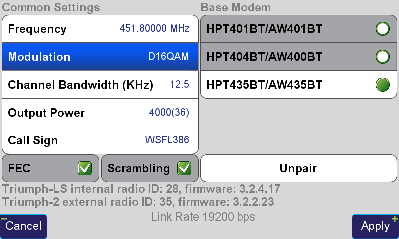
Configure the UHF Radio Parameters and Start the Base Station.
To start the base with 5-Hz corrections, the Broadcast Period must be changed to 0.2 seconds in the Base/Rover Setup. “RTCM 3.0 Min” should be chosen as the correction format. This format only broadcasts the RTCM messages needed for RTK positioning and excludes information containing signal-to-noise (CNO) and full milliseconds for code observations. A modulation must be selected that has a sufficient link rate to transmit increased data rates with 5-Hz corrections. With the Channel Bandwidth set to the FCC’s limitation 12.5 kHz, the D16QAM modulation must be used. With 2-Hz corrections (0.5 second broadcast period) D8PSK modulation can also be used.
UHF Modem Link Rates (bps)
Modulations with greater link rates have decreased receiver sensitivity to demodulate the signal; the downside to choosing modulations with higher link rates is that they are more subject to interference and data loss when the signal is weak. Field tests have found that D16QAM modulation decreases the working range of the radio approximately 20 percent compared to DQPSK modulation.
Radio settings for 5-Hz corrections.Radio settings for 5-Hz corrections.
After these settings in Base/Rover Setup have been modified, press the To Base button to apply them, and then the Start Base button to start broadcasting with the configured setup.
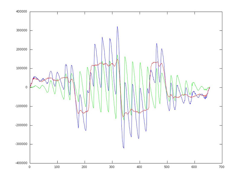
In addition, new signals on 1575.42+1.023*14 MHz (B1-2), 1176.45 MHz (E5A) and 1207.14 (E5B) frequencies for three satellites (PRN 32, 33, 34) also have been decoded and tested.
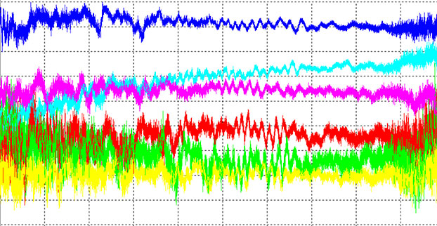
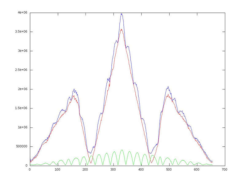
Here are graphs illustrating the experiment:
I of BOC(1,1) (red), BOC(6,1) (green) and their sum (blue) vs code shift.
dI of BOC(1,1) (red), BOC(6,1) (green) and their sum (blue) vs code shift.
Horizontal axis: 0 – minus one chip shift; 327 – zero shift; 655 – plus one chip shift
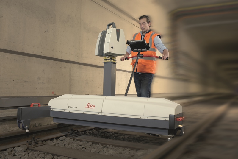
Leica Geosystems has released SiTrack:One, a highly accurate rail track maintenance and refurbishment system incorporating the Leica ScanStation P40 to generate 3D point clouds. SiTrack:One by Leica Geosystems ensures complete coverage of an entire rail infrastructure surface without the need to receive GNSS signals for position information, the company said.
With a new mounting design, the total solution for rail maintenance and refurbishment produces synchronized engineering, survey-grade 3D point clouds for accurate as-built drawings. The Leica ScanStation P40 can either be mounted vertically in the centre of the rails or inverted directly over the rail track. Rail bridge sleeper replacements can be measured quickly generating a numbered as-built replacement plan for each individual sleeper on a rail bridge.
The sophisticated system is equipped with two powerful distance measurement instrument (DMI) or odometers that provide accurate positioning in GNSS-denied areas, such as underground railway tunnels or underground subway networks. The system’s on-site calibration process guarantees permanent alignment of the relative position between the sensors and its onboard inertial measurement unit, guaranteeing position accuracy.
The German engineering firm Vermessungsbüro Riemenschneider GbR was the first to use the SiTrack:One by Leica Geosystems. When converting existing railway tracks in the course of track maintenance for the Deutsche Bahn AG, the firm required complete, accurate and consistent information on existing tracks, clear structure gauge, route topography and civil engineering works. With the SiTrack:One, Vermessungsbüro Riemenschneider GbR experienced significant workflow gains by leveraging the highly accurate point clouds directly into the engineering process.
“The SiTrack:One by Leica Geosystems guaranteed the complete survey of railway sidings with a minimum stay of surveying personnel in the danger zone of rail transport,” said Dipl.-Ing. Andreas Riemenschneider, principal of Vermessungsbüro Riemenschneider. “Thus, the costs of security measures were significantly reduced. The state-of-the-art system conforms efficiently to the demands for survey, visualisation, documentation, evaluation and approval of existing and new routes, all in accordance with rail transportation guidelines.”
Developed from acquired knowledge SiTrack:One is the first solution to be released under Leica Geosystems from the acquisition of the former Technet-Rail 2010 GmbH. Leica Geosystems acquired the previous firm’s specialised knowledge of geospatial big data for rail transportation networks in May to increase its mobile mapping offerings for the rail industry.
“One of our goals in obtaining this specific know-how was to provide users with a dedicated tool for passenger rail networks monitoring and maintenance, and with the development of SiTrack:One, we are taking the first step on this roadmap,” said Stuart Woods, Leica Geosystems Geospatial Solutions Division vice-president. “Professionals can now trust their measurements on rail are accurate even in the most difficult conditions.”
SiTrack:One by Leica Geosystems includes software enabling data synchronization, post-processing and feature extraction. This solution is part of the SiRail Suite, which includes the SiRailScan and SiRailManager software solutions.
SiRailScan allows for a complete extraction of the railway network with engineering accuracy level, while SiRailManager, the database management tool, creates a holistic view of an operator’s railway network from point cloud to geometry and signal layers. The combination of these solutions form the SiControl platform, which conforms to the requirements of the European Train Control System and produces complaint rail xml outputs for full train feedback control.
The new Leica Geosystems Pegasus backpack wearable mobile mapping solution. (Leica Geosystems AG, Switzerland, 2015)
The top Wichmann Innovations Award has been given to the Leica Geosystems Pegasus:Backpack, a wearable reality-capture technology that combines five high-dynamic cameras and two lidar profilers within an ultra-light and ergonomic carbon-fiber chassis. Leica Geosystems is a brand of Hexagon.
Companies from around the globe submitted products and applications to participate in the awards, which were presented by publisher Wichmann Verlag at the INTERGEO trade show, held in Germany in September. From hundreds of submissions, a jury of industry leaders selected 10 products and applications to receive votes from the general public. The main criteria for the awards were innovation, user-friendliness and practicality. Wichmann Verlag is known for its expertise in professional magazines and specialist books for geodesy and geomatics.
The Pegasus:Backpack is a mobile mapping solution that creates a 3D view indoors or outdoors for engineering or professional documentation at the highest level of authority while using SLAM (simultaneous localization and mapping) to determine position in GNSS-denied areas. With a focus on fast and efficient capture, calibrated images and point clouds are quickly generated for applications as diverse as BIM 6D to industrial training and disaster analysis, Leica said.
“The mobile mapping team has put a lot of hard work into understanding the needs of today’s professionals, and the Leica Pegasus:Backpack ensures they are not limited in how, where or when they collect their data,” said Stuart Woods, vice president of Leica Geosystems Geospatial Solutions Division. “With this achievement, the concept of mobile reality capture has been substantiated at the highest level and ushers in a new era in perception surveying and actionable mobile content.”
Watch a video about the backpack taken at INTERGEO:
Second place was awarded to Intergraph Security, Government & Infrastructure’s Green GIS, featuring the patented ECW (Enhanced Compression Wavelet) data compression format and ERDAS APOLLO software. Through the use of Hexagon Geospatial technologies, Intergraph’s solution drastically reduces data volume and minimizes storage demands and energy costs, leading to more efficient and environmentally friendly data centers.
“Software has a significant influence in terms of the enterprise carbon footprint. Our software-driven Green IT approach is absolutely new and pioneering, and effectively supplements previous environmental and climate protection efforts made by the information and communications technology sector,” said Maximilian Weber, senior vice president, Intergraph Security, Government & Infrastructure EMEA. “Our Green GIS can help lower carbon emissions of our customers’ IT processes.”
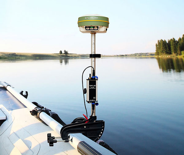
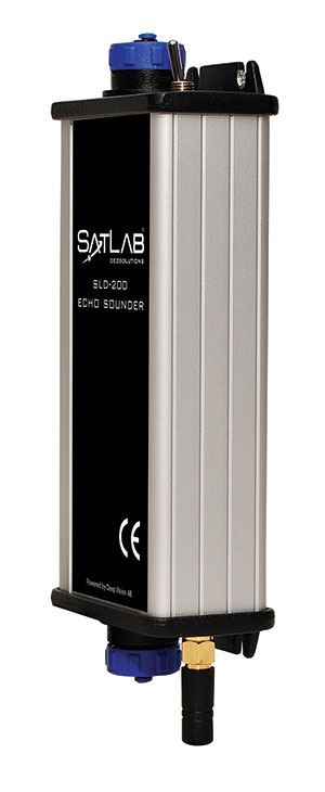
Swedish-based Survey and GIS equipment maker Satlab Geosolutions AB has announced the availability of its SLD-100 GNSS Rover accessory to facilitate Hydrographic measurement in bodies of water up to 100 meters in depth. It is designed for those who find themselves needing to survey into bodies of water, streams and rivers.
With survey-grade accuracy, the Satlab SLD-100 can be added to any brand GNSS RTK Rover to allow for position and depth measurements to be made simultaneously. With a built-in 10-hour lithium battery and transmitter unit with Bluetooth connectivity, the SLD-100 provides standard depth data streams in several industry standard NMEA formats at 1Hz, 4800 bps, providing compatibility with any hydrographic surveying software package.
“Our new SLD-100 survey receiver is extremely easy to use with position and depth information externally logged on a computer or controller,” said Birol Güçlüer”, CTO and partner of Satlab. “With the included transom mounting hardware, installation is quick and easy.”
The SLD-100 is available now for a suggested retail price of US$2995.
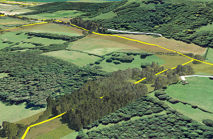
Bluesky has completed a multi-million pound aerial mapping project to assess the impact of vegetation on the electricity network of East Anglia and the South East of England. Working on behalf of UK Power Networks, Bluesky undertook the largest ever combined laser mapping and aerial photography survey commissioned by an electricity distribution network operator in the UK — some 34,000 square kilometers.
The laser mapped (LiDAR) data and aerial photographs were then analyzed to assess the proximity of vegetation to the overhead power lines in order to create a proactive three-year vegetation management program. Bluesky worked in partnership with ADAS, an agricultural and environmental consultancy, to complete the project.
Dedicated survey planes equipped with a lidar mapping system and aerial survey equipment flew the whole of the South East and East of England. Capturing millions of individual laser mapped height measurements and approximately 310,000 aerial images in just over three months, Bluesky successfully completed the unprecedented data capture element of the project within tight project deadlines, in challenging weather conditions and in adherence with strict Air Traffic Control restrictions.
The 80 terabytes of raw data was then processed and analyzed to identify which overhead line spans had vegetation infringement; for example the length of vegetation infestation along each span and its location and distance from the overhead line.
This information has now been incorporated into a 3D web portal that can be viewed from the desktop, enabling UK Power Networks employees to carry out virtual patrols of the network, saving time and reducing the risk of foot patrols, sometimes across difficult terrain including physical barriers such as rivers, ditches, livestock and numerous other potential hazards.
“This innovative £2.5 million project is of immense benefit to our customers and to the company,” said Nigel Hall, head of service development at UK Power Networks. “The risk-based tree-cutting program will help reduce tree-related power cuts for customers, with the additional benefit that it could be carried out without any disturbance to local landowners because it was done from the air rather than on foot.
“As a company it will help us get best value from our £19 million annual tree cutting budget, and the web portal will mean staff can carry out ‘virtual patrols’ from their desk, saving them time and reducing the potential hazards if they had had to walk the lines themselves.”
“Prior to commissioning the LiDAR and aerial mapping project, UK Power Networks undertook regular manual surveys as part of its assessment of network resilience, but the capture of LiDAR and associated aerial photography for the entire catchment area allows for evidence based decision making and long term planning, and provides a proven solution for other network operators,” added Rachel Tidmarsh, managing director of Bluesky.
Roy Dyer, Head of Arboriculture in ADAS and manager of the ADAS contribution to this contract said, “This has been a ground breaking contract. The combination of Bluesky’s technical ability and ADAS’ consultancy experience in managing vegetation near overhead lines enabled us to successfully deliver this challenging contract and improve the management and resilience of the overhead lines owned by UK Power Networks.”
 BlueStarGPS offers both GPS and GNSS options in a rugged, lightweight package. The BlueStarGPS device was designed to meet sub-meter mapping and data collection needs in the pipeline and utility industries. It provides sub-meter precision without post-processing, and maintains accurate positioning when the SBAS signal is obstructed. This means it can function under trees, around buildings and in rugged terrain where other receivers can fail.