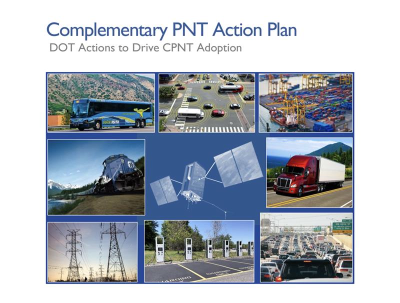
The U.S. Department of Transportation (DOT) has unveiled its Complementary Positioning Navigation and Timing (CPNT) Action Plan, which contains steps the department is taking to drive CPNT adoption across the United States transportation system and within other critical infrastructure areas. This plan was mentioned by Robert Hampshire — Deputy Assistant Secretary for Research and Technology and Chief Science Officer, U.S. DOT — during his keynote address at the annual Civil GPS Service Interface Committee (CGSIC) meeting on September 12, at ION GNSS+, which GPS World’s Editor-in-Chief, Matteo Luccio, is attending.
In 2020, the U.S. DOT Volpe National Transportation Systems Center conducted field demonstrations of various PNT technologies that could offer complementary service if GPS is disrupted. The department was able to gather information on PNT technologies at a high technology readiness level that can work in the absence of GPS.
The U.S. DOT have selected 11 candidate technologies to demonstrate positioning or timing functions:
Two vendors demonstrated low-Earth orbit satellite PNT technologies — one L-band and one S-band;
two vendors demonstrated fiber-optic timing systems, both based on the White Rabbit Precision Time Protocol;
one vendor demonstrated localized database map matching database, inertial measurement unit, and ultra-wideband technologies; and,
six vendors demonstrated terrestrial radio frequency PNT technologies across low frequency, medium frequency, ultra-high frequency, and Wi-Fi/802.11 spectrum bands.
Five of the selected technologies were demonstrated at Joint Base Cape Cod in Massachusetts, and six were demonstrated at NASA Langley Research Center in Virginia. The demonstrations were scenario-based implementations modeled on critical infrastructure use cases under different operating conditions.
Two central recommendations from the demonstration were made: the U.S. DOT should develop system requirements for PNT functions that support safety-critical services; and the U.S. DOT should develop standards, test procedures, and monitoring capabilities to ensure that PNT services, and the equipage that utilize them, meet the necessary levels of safety and resilience identified in recommendation one.
The U.S. DOT has also released a request for information (RFI) as one of the steps in driving adoption of complementary PNT services to augment GPS. The department is planning a resiliency test, evaluation, and performance monitoring strategy for PNT-dependent transportation systems.
If any readers are interested in participating, click here for more information.
Qualcomm has entered a technology agreement with Hyundai Motor Group to integrate its Snapdragon Automotive Cockpit Platform into Hyundai Motor Group’s purpose-built vehicles (PBV).
The infotainment systems on the PBVs will use Snapdragon Automotive Cockpit Platforms for a “holistic, seamlessly connected and smart user experience,” Qualcomm said.
The PBVs are designed to deliver transportation, comfort, logistics, commercial and healthcare services. The latest generation of Qualcomm’s Snapdragon platform benefits from optimized power consumption, high-definition graphics and immersive multimedia and audio.
According to Qualcomm, the latest generation of Snapdragon Automotive Cockpit Platforms offer optimal power consumption while providing top-tier graphics as well as top immersive multimedia and audio experiences.
The platforms offer location services, emergency calling, noise reduction, and dual SIM capability as well as cloud-based monitoring and management systems. Using Qualcomm’s artificial intelligence (AI) engine and machine learning (ML) capabilities for intuitive and intelligent systems, Snapdragon can support digitally advanced applications, including in-vehicle virtual assistance and adaptive human interfaces. It can also facilitate natural communication between the vehicle and passengers for added safety and comfort.
The platform also employs dynamic configuration management to ensure vehicles are kept up to date. Reliable cloud-based vehicle monitoring and management also is possible through cloud service solutions.
Qualcomm and Hyundai Motor Group have been collaborating since 2011 on in-vehicle mobile communications using Snapdragon Automotive Connectivity Platforms.
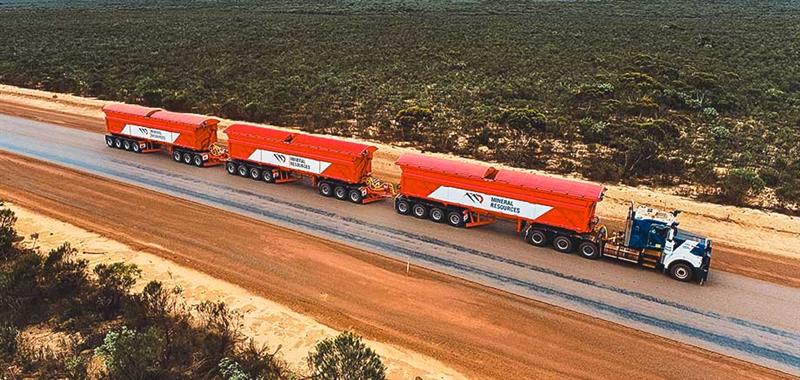
Hexagon has partnered with Mineral Resources (MinRes) to provide an autonomous haulage solution for a fleet of 120 fully autonomous road trains in Australia. The company says this will transform safety, productivity and sustainability in the region.
The fully autonomous road trains are a full-site, truck-agnostic solution. The addition of unmanned and autonomous systems will form an essential part of the supply chain for the MinRes Onslow Iron project in Western Australia’s Pilbara region.
The center of the autonomous platooning system is Hexagon’s autonomous solutions stack integrating drive-by-wire technology with an autonomous management system to orchestrate vehicle movement in road train haulage.
“Today’s agreement with MinRes will ensure that off-road transport activities will be safer, more sustainable, and more productive,” Paolo Guglielmini, president and CEO of Hexagon, said. “I’m excited to see how similar solutions can be applied in other off-road markets such as agriculture and heavy industry.”
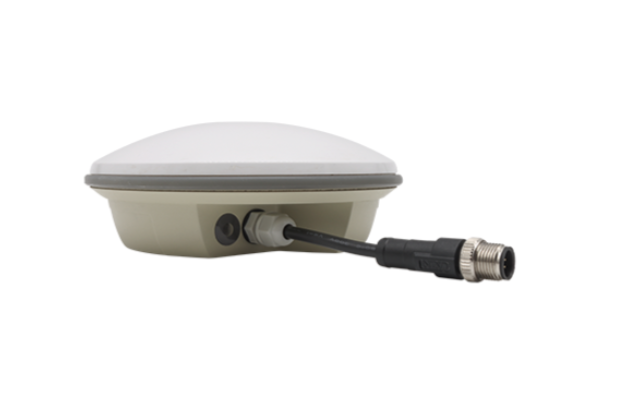
Harxon has launched its TS122 family of smart antennas for demanding precision agriculture applications to increase GNSS availability, accuracy and reliability.
The smart antenna family is designed for high-performance semi-autonomous or autonomous applications that require centimeter-level accuracy – even in highly variable terrain and GNSS-obstructed environments. The TS122 family can be used for agriculture OEMs, integrators that develop precision agriculture solutions, autonomous solution providers and more.
There are two models for the new TS122 smart antenna: EUAA and EUUB. Each model has different performance options to fit users’ individual needs.
TS122 EUAA, with ±10cm P2P accuracy and standalone technology, is best for high-performance semi-autonomous or autonomous applications requiring centimeter-level accuracy, even in challenging GNSS-obstructed environments.
TS122 EUUB has single point 1.5 m circular error probable (CEP) and ±15cm P2P accuracy. Both models support RS-232 serial ports and Bluetooth communication for easy configuration of the smart antenna via users installing a configuration app on a phone or tablets, the company said.
Mapbox, a maps and location platform, has released new platform updates to enhance user’s 3D mapping experience by adding powerful dynamic lighting capabilities and landmark 3D buildings.
The new ready-to-use platform aims to enhance wayfinding and spatial orientation for users and provides a polished canvas for custom location data. Mapbox Standard is now accessible in public preview and available in pre-releases of the latest versions of its web and mobile SDKs.
Dynamic lighting for a natural day to night shift
Mapbox Standard provides four lighting presets: day, night, dusk and dawn. As the sun moves throughout the day, based on a user’s location, shadows shift and highlight different areas of the map. The dynamic lighting creates a true-to-life experience that can help users better orient themselves in the physical world.
Image: Mapbox
Landmarks improve map comprehension in 3D
As part of Mapbox Standard, Mapbox has created a dataset of hundreds of recognizable landmarks across the globe, with more being added each month. The landmark buildings integrate seamlessly into the map environment and respond dynamically to lighting changes.
Therefore, our cartographers chose a sleek and beautiful symbolic realism design for Mapbox Standard design that offers users an easy-to-read map where elements such as landmarks, buildings, roads and trees are clearly identifiable while keeping icons, labels and custom location data elements visible.
Users can choose between the new 3D elements and the 2D map within their application. Mapbox Standard is built with a base map that evolves alongside custom layers, delivering up-to-date rendering features and data layers without a manual style update or version upgrade.
To explore the new Mapbox Standard style, click here.
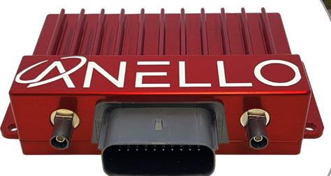
Powered by ANELLO’s optical gyroscope technology and artificial intelligence-based sensor fusion engine, the ANELLO GNSS INS delivers robust, high-accuracy positioning and orientation for applications such as agriculture, construction, trucking, and autonomous vehicles.
The ANELLO GNSS INS comes equipped with unaided heading drift of less than 0.5°/hr, dual multi-band real-time kinematic capable GNSS engines, ASIL-D ready automotive qualified CPU, automotive 2-wire Ethernet, and dual high-speed CAN FD interfaces.
It also features dual RS-232 interfaces, hardware precision time protocol, IEEE 802.1AS. The ANELLO GNSS INS is IP68 waterproof, as well as resistant to dust, salt spray and chemicals.
“Seen & Heard” is a monthly feature of GPS World magazine, traveling the world to capture interesting and unusual news stories involving the GNSS/PNT industry.
Bikes get tricked out
Image: Snik Bike
Snik Bike is a new app-paired tracking device designed to help users track their bikes if they are lost or stolen, reported North Shore News. Snik Bike Security Co-founder Fraser Vaage developed Snik Bike after having two of his bikes stolen. Snik equips any bike with a rechargeable location device that can be installed in five minutes or less. After pairing the device, the bike is automatically registered with Project 529, which is an online bike registration service. Vaage emphasized that while this device is not a ride-tracking software, such as Strava, it acts as an odometer, tracking overall mileage. The battery is only activated when a bike is stolen, Vaage said, therefore, it’s unlikely Snik will run out of battery. However, if it does, the device diverts to AirTag technology as a backup.
Lighthouses no more
Image: Wiltser/E+/Getty Images
With the wide adoption of GNSS, lighthouses on U.S. shorelines are no longer needed for navigation. To preserve these properties, the General Services Administration has been transferring ownership of the lighthouses to anyone willing to preserve them, reported The Guardian. This year, six lighthouses are being offered to federal, state or local government agencies, non-profits, educational organizations or anyone willing to make them publicly available for educational, cultural, or recreational purposes.
Location data ad weather resiliency
Image: DenisTangneyJr/E+/Getty Images
A Southern Methodist University research team, led by Nicos Markris, measured Dallas’ resilience by recording anonymous cell phone location data among residents in the Dallas metroplex before, during, and after the February 2021 North American winter storm. Measuring a city’s resilience is critical for planning responses to future events and uncovering potential vulnerabilities. By averaging location data, Makris and his team outlined the movement patterns of Dallas residents during a typical week. They compared the normal movement patterns to those during and after the week of the winter storm to determine when Dallas started getting back to normal.
GPS mitigates natural disasters
Image: Philip Thurston/E+/Getty Images
NASA’s Jet Propulsion Lab (JPL) is testing new ways to detect tsunami-like ocean waves before they cause catastrophic damage. The GNSS Upper Atmospheric Real-Time Disaster Information and Alert Network (GUARDIAN) is a new experimental monitoring system that can use data from clusters of GPS and other satellites to detect deadly waves triggered on Earth. Radio signals from GNSS are examined by scientific ground stations around the world. That data is then reviewed by the JPL’s Global Differential GPS network to help mitigate disasters. The GUARDIAN is still evolving and may be used in the future to develop early warning strategies, according to the United Nations’ International Committee on GNSS.
Innoviz Technologies, a lidar technology company, and the BMW Group, a manufacturer of vehicles and motorcycles, have collaborated on a B-sample development phase for a new-generation of lidar. Under the development agreement, Innoviz will develop the B-samples based on its second-generation InnovizTwo lidar sensor to enable Level 3 automated driving capabilities.
“Lidar is one of the critical technologies underpinning Level 3 or even higher automated functions,” Nicolai Martin, BMW Group’s SVP of driving experience, said. “Optimizing lidar technologies and costs are the major challenges in order to bring Level 3 highly automated driving into the mainstream.”
The companies already have been working together for a few years on an existing program that includes the first deployment of lidar-enabled highly automated technology on the BMW 7 Series, which will launch later this year.
In addition to the lidar solution for the BMW 7 Series, the BMW Group and Innoviz have started the first phase of development for a lidar-based minimal risk maneuver system (MRM). The MRM acts as a secondary safety driving decision platform that will leverage the InnovizTwo lidar sensor to manage real-time driving decisions.
The United Kingdom’s first fully electric self-driving bus began service on public roads from the Didcot Parkway railway station in June, reported the BBC.
First Bus, the UK’s largest bus operator, said the bus’ radar, lidar and artificial intelligence technology could safely steer, accelerate and brake without human intervention.
While the bus is fully autonomous, it does have a safety driver who is able to override operations if needed.
The 15-seat bus makes a six-mile loop from the station to Milton Park in Oxfordshire, UK, and runs six days a week every 40 minutes.
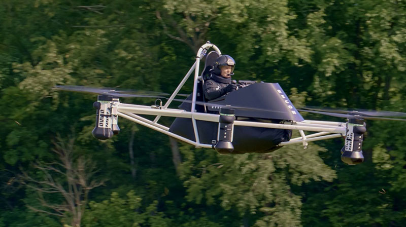
The U.S. government has visibly and physically conveyed its interest in getting air taxis into operation, through a visit of 70 people — attached to the newly formed Advanced Air Mobility (AAM) Coordination group — to Archer Aviation. The group talked with the executives of the company developing the “Midnight’ air-taxi aircraft and watched a flight test.
The AAM group includes members from leading government agencies concerned with making and keeping this segment of aviation successful, including the Federal Aviation Administration (FAA), the Department of Transportation (DOT), the National Aeronautics and Space Administration (NASA), the Department of Defense (DOD) and other agencies.
AAM group visits Archer Aviation. (Image: Archer Aviation)
Gathering the views of Archer and other electric vertical takeoff and landing (eVTOL) developer executives should be an essential part of the AAM group’s information collection task. And while it’s great to see that the interagency group has every intention of promoting the AAM concept of air taxis, it would perhaps be better if the group also had access to representatives of manufacturers, developers, and those with UAS experience. It’s clear that we need to start by spreading the word, but also by including people in the group who have dedicated themselves to bringing these capabilities to market — that may make the process more efficient.
Along the way, it may also help to understand that the processes we have used in the past to get airframes like this into passenger carrying operations might not work well with this new industry. It’s understandable that it should take a lengthy period to assess, verify, qualify and certify such vehicles in the name of safety, but if companies run out of cash and fold in the interim — which is highly likely with this “start-up industry” — then shouldn’t we be looking for a better way to get these guys off the ground?
No one wants safety to be sacrificed, but could there be some way to streamline, speed up, or simplify the process without skipping essential steps — a way to get new technology into use before it’s obsolete, or a lack of start-up money dooms its progress? The forecast for the economy in the near future is in the billions of dollars. So, providing funding to improve the current processes does make sense. DOD has started to put serious effort into speeding up its acquisition process and has empowered the Defense Innovation Unit (DIU) to find quicker ways to bring commercial technologies into defense.
The processes used to bring new technologies into use are tried and proven, but they are lengthy. In defense, if our opposition can field things quicker than we do, they have an edge in strategy, tactics and a higher probability of winning in battle. These countries are using the same approaches in the commercial world too, and we need to be wary that they may also have a greater chance of winning the “economic war.”
Nevertheless, Archer in California and others such as Joby, also in California, and Liliam in Germany, plod on through varying stages of FAA and European Union Aviation Safety Agency (EASA) certification paths. An example of the effort that a company has been required to put into fulfilling the requirements of a certification agency is that of Lilium, which first applied for its Design Organization Approval (DOA) in 2017, is still churning through the qualification efforts and does not expect approval until 2025. Of course, the answer is “Don’t get on the certification ‘hamster-wheel’ unless you can stand the journey.” However, we do want these systems and vehicles to make it in order to overcome some of the traffic nightmare that we are living through in our major cities and to contribute to the growth in the economy.
Meanwhile, the great hope (even expectation) of the “flying car” is being kept alive by Doroni in Miami with its two seat H1 eVTOL. Having largely burnt through its $3.6 million StartEngine launch money, Doroni is looking for its second round of funding to build more prototypes and join the certification race. However, other single seat eVTOL flying cars have taken the easier route to certify under the FAA Ultralight category.
Doroni H1 prototype. (Image: Doroni)
The H1 has semi-autonomous capability, which Doroni claims will make its eVTOL easy to fly, and allow general sales to any car driver. With air bags, an aerodynamic fuselage — which generates lift — 10 independent propulsion systems (four double prop ducted fans and two forward thrust props), an airframe that can behave as a parachute and “dissipate energy” in case of a crash, and landing gear, the H1 also has multiple independent batteries — all aimed at safety, which will help make it through certification verification. So, if you happen to have the $250,000 proposed sale price and are willing to wait on the completion of FAA certification, you could own your own “flying car.”
Doroni just announced that they have already made 50 test flights within their manufacturing facility along that test and qualification road.
Meanwhile, Ryse Aerotech in Ohio, recently demonstrated a manned test flight of its single seat Recon eVTOL — billed as an aid to farmers, with a top speed around 58 mph, a range of about 25 miles and with the right FAA clearance it could even reach an altitude of 700 ft — an airborne ATV for inspecting crops and the like.
Recon manned test flight in June 2023. (Image: Ryse Aerotech)
The path to market that Ryse has selected, however, should see more vehicles in earlier use than Doroni’s H1. All you may need is a driver’s license to take off in a Recon because it’s qualified as an Ultralight craft — just buy and fly. Beware, you cannot fly anywhere near an airport or after dark. FAA has restrictions on Ultralight craft.
So, progress on the semi-autonomous “flying-car” front and a plea to consider the economic benefits and to look to how to improve the efficiency of the existing certification process — not a request to cut corners, rather a request to speed up the processes and save this start-up industry before it goes broke.
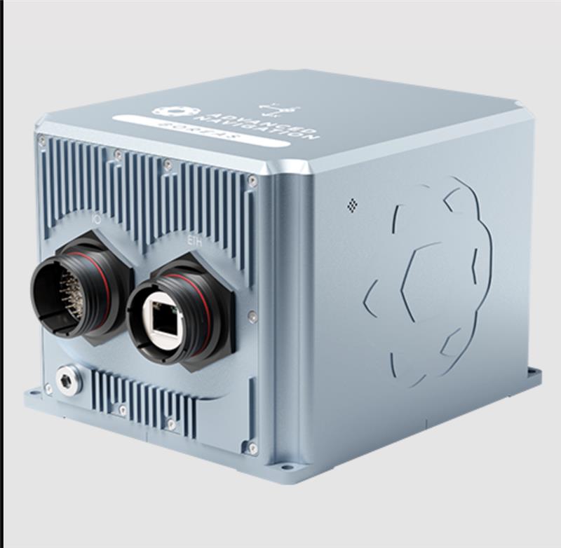
Advanced Navigation has expanded it Boreas digital fiber-optic gyroscope (DFOG) range, with the A series.
The Boreas A90 and A70 are strategic-grade inertial measurement units (IMU) that deliver acceleration and orientation with accuracy, stability and reliability under all conditions with no reliance on GNSS. They also feature automatic gyrocompassing.
The IMUs contain ultra-high accuracy DFOG and high performance closed-loop accelerometers. The Boreas A90 and A70 are both suitable for surveying, mapping and navigation across subsea, marine, land and air applications.
The Boreas A90 and A70 also offer an optional license to add INS capabilities and enable integration with external GNSS receivers using Advanced Navigation’s range of interfaces and communication protocols.
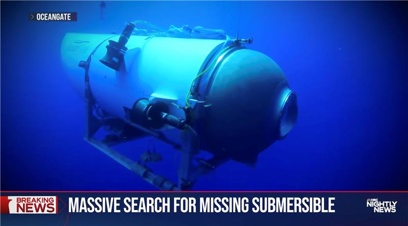
OceanGate. (Credit: Screenshot of NBC news coverage)
On June 17, an OceanGate Expedition Titan submersible launched off the coast of Newfoundland, Canada, carrying five passengers to the bottom of the Atlantic Ocean to explore the infamous R.M.S. Titanic shipwreck. The U.S. Coast Guard said that the submersible lost contact with the surface vessel about an hour and 45 minutes after the launch and has not been in contact since.
The submersible can support life for 96 hours. As of the afternoon of June 20, it had 40 hours of oxygen left and U.S. and Canadian agencies were still searching for it.
The Titan submersible explained
According to the OceanGate website, the Titan is “a Cyclops-class manned submersible designed to take five people to depths of 4,000 [m] (13,123 [ft]) for site survey and inspection, research and data collection, film and media production, and deep-sea testing of hardware and software.” The Titan is equipped with an inertial navigation system (INS), an ultra-short base line acoustic positioning system, a robotics laser scanner, a Teledyne 2D sonar and more.
While it is equipped with an INS, the Titan relies on messages from a surface ship to guide the submersible to the shipwreck. The submersible and surface vessel rely on Elon Musk’s Starlink satellites for communication.
A part of the Titan worth mentioning, the crew is sealed inside and bolts are applied to the outside — needing an external crew to remove them upon surfacing.
Foreshadowing
The New York Postreported, in 2022, that an OceanGate Expedition to the Titanic lost contact for more than two hours and never found the wreck.
Aboard the submersible was a CBS correspondent, David Pogue, who was filming a segment for CBS Sunday Morning. He tweeted about the incident.
There are 18 planned expeditions to the Titanic with OcenGate Expeditions to survey the shipwreck, collect data, and document high-resolution images and videos.
The entire trip to the Titanic wreck site takes 8 days, and one dive can take up to 10 hours. The expedition is comprised of five legs.