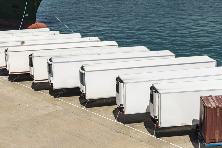
Telematics company SkyBitz has announced a strategic technology partnership with fleet logistics solutions provider Coretex. The partnership combines Coretex sensor-based refrigeration solution and cloud-based software platform with SkyBitz trailer tracking technology to create a complete solution for businesses needing both powered and non-powered asset tracking.
With the partnership, food, pharmaceutical and retail customers can have total visibility into the status of loads during transportation, resulting in improved food safety and quality assurance.
The SkyBitz and Coretex partnership allow customers to access and manage both reefer device data and trailer tracking data via one seamless solution, enabling greater insight, a more transparent view of their entire cold chain operation, and better decision making. Customers can now automate Food Safety Modernization Act (FSMA) compliance, allowing them to keep assets on the road for longer, monitoring them with advanced temperature tracking capabilities.
“Our customers look to us for innovative, value-driven solutions that help improve profits across their entire operation,” states Henry Popplewell, DVP and president of SkyBitz. “As leaders in the supply chain and logistics arena, we are excited to capitalize on this partnership to continue to grow our cold chain customer base and align ourselves with the foodservice industry through this technology partnership. The Coretex pedigree in last-mile food and beverage distribution is the perfect complement to our asset management technology.”
With this new offering, customers of Coretex and SkyBitz will benefit from the following:
More than 50 features of remote cold chain monitoring capabilities, including two-way reefer control, monitoring of up to six doors, and advanced power management to preserve reefer and telematics unit battery life.
Single point of access to critical and timely best-in-class trailer utilization and reefer information on one seamlessly connected platform, greatly expanding productivity and streamlining operations.
Communication between the trailer and other connected sensors with options to expand to additional Coretex products such as assurance solution CoreTemp.
An unmatched compilation of integrated driver safety, compliance, and asset management tools including the Coretex integration with trailer braking solutions and automatic tire inflation systems.
“Combining SkyBitz leading trailer and asset management technology with Coretex cloud-based software platform, two-way reefer solutions, and deep compliance capabilities create a powerful solution for both companies,” said Coretex CEO Selwyn Pellett. “At Coretex, reefer solutions have been a core part of our business for 16 years, and we’re excited to share our experience with SkyBitz. The trailer expertise of SkyBitz complements our offering, perfectly creating a solution that can help businesses increase the productivity of their assets. With the growing importance of food safety assurance for both food producers and distributors, we think both companies’ customers will find our combined fully-featured solution the best on the market.”
“Seen & Heard” is a monthly feature of GPS World magazine, traveling the world to capture interesting and unusual news stories involving the GNSS/PNT industry.
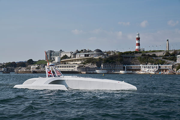
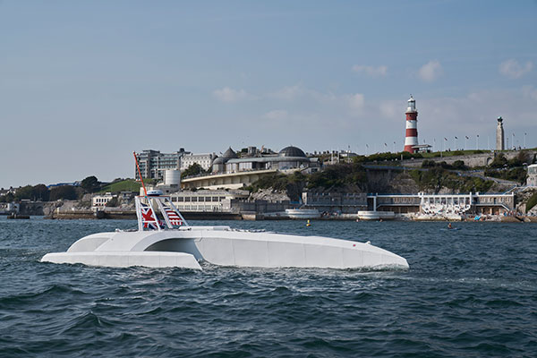
The Mayflower autonomous ship. (Photo: Tom Barnes for IBM)
No pilgrims needed aboard
The autonomous Mayflower trimaran launched Sept. 16 from Plymouth, England, on a mission to traverse oceans and gather vital environmental data, guided by Veripos GNSS and inertial measurement units from iXBlue and Silicon Sensing. Ocean research non-profit ProMare joined with IBM on the Mayflower Autonomous Ship — an artificial intelligence and solar-powered marine research vessel, two years in the making. Designed to provide a safe, flexible and cost-effective way of gathering data about the ocean, the Mayflower works in tandem with scientists and other autonomous vessels to help understand critical issues such as global warming, micro-plastic pollution and marine mammal conservation.
Photo: nycshooter/E+/Getty Images
A Guardian on the Bus
A school bus app aims to help monitor students’ exposure to others. App developer CalAmp’s Bus Guardian uses the same technology from its Here Comes the Bus app with an added layer of contact tracing. With Bus Guardian, parents can opt-in and invite their student to check on and off the bus. It uses telematics to convert a school bus into a contact tracing solution. Schools can deliver instant and actionable reports of ridership based on contact tracing — important if a student or driver becomes ill.
The Erta Ale volcano. (Photo: guenterguni/E+/Getty Image)
Rift splits Africa in two…eventually
GPS data is refining predictions of when Africa will split into two continents. In 5 to 10 million years , the Gulf of Aden and the Red Sea will flood the Afar region and the East African Rift Valley, creating a new ocean and continent. GPS data is precisely measuring ground movement as three tectonic plates peel away from each other at a triple junction, said Ken Macdonald, professor emeritus, University of California, Santa Barbara. “With GPS measurements, you can measure rates of movement down to a few millimeters per year,” Macdonald said. “As we get more and more measurements from GPS, we can get a much greater sense of what’s going on.”
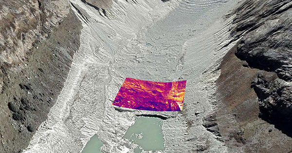
Image: Rosie Bisset
Dangerous Retreat
In a first for mapping glacier retreat in the Peruvian Andes, the CASCADA UK + Peru glacier project used a drone fitted with a FLIR Vue Pro R 640 thermal-imaging camera for insight. A thicker layer acts as insulation. Researcher Rosie Bisset, Edinburgh University, is building a mosaic of the images to better understand how surface cover is affecting the melt rate. The glaciers have shrunk by about 30% in the past few decades, and pose a serious threat to the water supply of in the Ancash region.
A roundup of recent products in the GNSS and inertial positioning industry from the October 2020 issue of GPS World magazine.
OEM
GNSS antennas
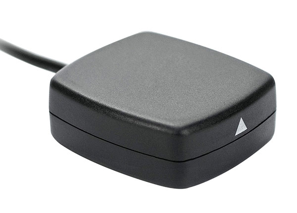
Active and passive
Photo: 2J Antennas
A new range of high-precision GNSS antennas is designed for superior accuracy and reliability, with both active external antennas and passive internal ceramic antennas. The antennas provide precision, high bandwidth, and an advanced signal design for GPS, GLONASS, BeiDou, Galileo, IRNSS and SBAS navigation. They are designed for demanding GPS applications that require centimeter-level accuracy by combining precise point positioning (PPP) of L1 and L2 or by combining L1 and L5 bands with real-time kinematic (RTK) satellite navigation. Applications include aviation safety, UAVs, transportation, autonomous vehicles, agriculture and land and hydrographic surveys.
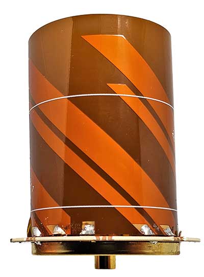
The HC976 housed and HC976E embedded helical antennas are light and compact, suitable for applications ranging from autonomous navigation to GNSS timing. Both models support GPS/QZSS-L1/L2/L6, GLONASS-G1/G2, Galileo-E1/E6, and BeiDou-B1/B3 frequency bands as well as regional augmentation systems and high-precision L-band correction services. The HC976 and HC976E support QZSS-L6, Galileo-E6 and BeiDou-B3. The HC976 is 44 x 62 millimeters and weighs 42 grams. It features a precision-tuned helical element that provides an excellent axial ratio and operates without the requirement of a ground plane, making it suitable for a wide variety of high-precision applications.
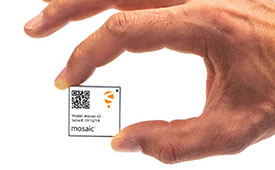
The mosaic-T GPS/GNSS receiver module is built for resilient and precise time and frequency synchronization under challenging conditions. Its multi-frequency, multi-constellation GNSS technology with AIM+ Advanced Interference Mitigation algorithms allows mosaic-T to achieve maximal availability even in the presence of GNSS jamming or spoofing. The compact surface-mount module is designed for automated assembly and high-volume production. Mosaic-T delivers timing and has additional inputs for an external high-accuracy clock.
The HGuide n380 inertial navigation system (INS) communicates an object’s position, orientation and velocity when GNSS signals are unavailable. It is built to withstand harsh environments in the air, on land or at sea. It is designed to meet the need for a small, high-performance INS for 3D mapping, surveying and other applications where space is at a premium. It is composed of Honeywell’s HGuide i300 inertial measurement unit (IMU), a GNSS receiver and Honeywell’s proprietary sensor-fusion software, which is based on the algorithms used for navigation on millions of aircraft every day.
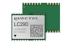
The LC29D eMobility module is a sub-meter-level GNSS module that integrates dead-reckoning and multi-band (L1/L5) real-time kinematic (RTK) algorithm technologies with fast convergence times and reliable performance. The module supports dual-band GNSS raw data output and integrates a 6-axis IMU sensor to deliver high-accuracy positioning performance in seconds. Based on the Broadcom BCM47758 GNSS chip, the LC29D can concurrently receive signals from up to six constellations (GPS, GLONASS, Galileo, IRNSS, BeiDou and QZSS), which maximizes the availability of sub-meter level accuracy. It offers a position update rate of up to 30 Hz (fusion output), enabling dynamic applications like shared emobility, delivery robots and precision agriculture to receive position information with lower latency.
The AlphaUni 300/900/1300 lidar series provides light, versatile long-range laser scanner systems for the high-end market. The series provides optimized data sets powered by advanced GNSS/inertial navigation system (INS) sensors and long-range Riegl scanners. AlphaUni’s design adapts to a variety of applications and can be installed on a variety of platforms, including multi-rotor UAV, fixed-wing vertical-takeoff-and-landing (VTOL) UAV, vehicles, rail trolleys, backpacks, boats and more.
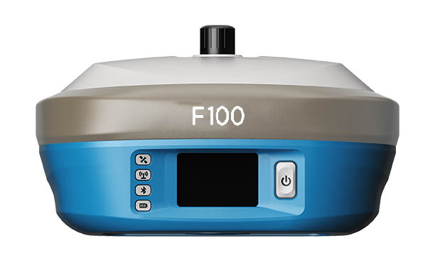
The F100 GNSS receiver, an upgrade to the F90, is designed to meet surveyors’ demands for high field performance, flexibility and cost-effectiveness. It tracks multiple constellations (GPS, GLONASS, Galileo, BeiDou) and can maximize the acquisition and tracking process with all-in-view GNSS frequencies. The 1.45-inch color LCD display is a multi-touch capacitive screen. The F100 has 32GB of internal memory. Its integrated second-generation web user interface control is compatible with all devices and browsers.
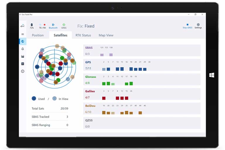
Eos Tools Pro for Windows 10 implements powerful new features that enable users to exploit all four global GNSS constellations and a state-of-the-art NTRIP client to access real-time kinematic (RTK) bases and RTK networks all over the world via NTRIP, Direct IP and wireless radios. It provides the latest support for Windows Geolocation and other features by Microsoft to allow customers to use high-accuracy locations directly in their apps, such as RTK network/RTK base connectivity, support for all new Beidou and Galileo satellites, and SafeRTK functionality for areas with marginal cellular coverage. Features for app developers are also available.
The BB4 UAV high-end multi-rotor drone is optimized for the AlphaUni 300/900/1300 lidar series. Its modular design simplifies deployment in just a few minutes. Its 7-kg payload breaks the capacity barrier, and its more than 45 minutes of flight time increases the airborne lidar survey ability. The redundant CHCNAV and DJI inertial measurement unit (IMU) and GNSS unit provide reliable centimeter real-time kinematic (RTK) positioning, meeting the demand for high accuracy in the geospatial and mapping industries.
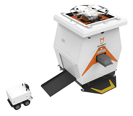
The ADNET autonomous delivery network is a technical solution to transport medical samples and quarantine materials in cities. It uses an RA3 drone, unmanned vehicle RG1 and RH1 hub station to deliver medical supplies without relying on manpower, alleviating time spent in traffic and the cost of traditional delivery. Supplies retrieved by the RG1 vehicle are delivered to the RH1 hub for sorting and redirecting, while the drone transfers the supplies between hubs. The RG1 then delivers goods on the receiving end. The system was demonstrated during China’s COVID-19 epidemic prevention and control period, reducing contact between samples and personnel.
The VECTOR-400 is a compact autopilot designed specifically for unmanned aerial vehicles. It features a robust enclosure and a military-grade connector for harsh environments (MIL-STD 810 and MIL-STD 461). Features enable sea-skimming (extremely low-level flight) and the capability to navigate without GNSS. The VECTOR-400 is able to continue a mission in case of individual sensor failure and when subject to jamming, maintaining accurate estimations of attitude and position. Advanced algorithms provide stall prevention and the ability to carry out an efficient gliding maneuver in case of engine failure. Its air data attitude and heading reference system and inertial navigation system provide high-precision attitude information and reliable navigation under demanding circumstances.
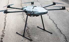
The F700 DroneHunter UAS is a radar-based autonomous interceptor drone for tracking and stopping dangerous drones. Its flexible undercarriage offers interchangeable counter measures for single, multiple or swarm-based threats, while its lightweight carbon-fiber frame enables quick speed and response. The F700 can carry multiple types of anti-drone countermeasures and deploy them in real time, based on which dynamic threat is detected miles beyond the protected area. The pogo pins and payload snaps of the undercarriage are integrated with artificial intelligence for firing and flight software.
Drones equipped with cost-intensive cameras and sensors need protection in the event of a flight-system failure. A parachute system for the DJI M210 drone is now available. Both commercial and emergency response operations are using the M210; its design and flexibility allow for a variety of industry-specific applications. The DRS-M210 parachute system is designed to ensure high pendulum and wind stability, allowing a damaged drone to land safely with minimal impact.
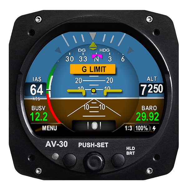
Altitude indicator (AI) or directional gyro (DG) replacement
Photo: uAvionix
The AV-30-C aircraft panel display adds a suite of in-flight information for pilots, including GPS navigational data, a probeless angle of attack indicator, baro-corrected altitude, indicated/vertical/true airspeed, non-slaved heading, bus voltage and G load. It is designed to fit into any aircraft with a 3 1/8-inch round instrument slot without cutting or modifying the panel. It is authorized for FAR Part 23 Class 1 and Class 2 aircraft listed on the AV-30-C Approved Model List (AML), containing 635 aircraft models including Cessna, Piper, Beechcraft, American Champion, Maule, Boeing, Swift, Mooney, Aviat and others.
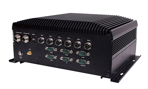
The R3S series of rugged, EN-50155-certified fanless vehicle/rail computers is equipped with a u-blox NEO-M8N module, which receives GPS, Galileo, GLONASS and BeiDou with the default set for GPS + GLONASS dual band. The series offers power-efficient performance for consolidating in-vehicle workloads such as video surveillance, control/monitoring, passenger information and Wi-Fi hotspot sharing. For edge-to-cloud connectivity, R3S uses its internal GPS/GLONASS chipsets for GPS tracking and has two M.2 slots with up to 4x SIM card readers for failover LTE connection. To ensure proper operations in moving vehicles, the series is certified with EN50155, EN50121-3-2, EN50121-4, EN50125-3, EN45545 and E13 standards and has passed MIL-STD-810G shock and vibration resistance certifications. The series can operate under a wide temperature range and offers excellent reliability in harsh railway settings. It has one external removable 2.5-inch HDD/SSD drive bay for recorded footage storage. For consolidating in-vehicle workloads such as in-vehicle control/monitoring and passenger information, the R3S features a variety of I/O support, including 2x HDMI, DI/DO, 3x COM/CAN BUS and 4xUSB ports.
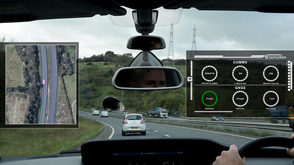
GNSS augmentation solution targets North America and Europe with safe and precise centimeter-level accuracy performance from two geostationary satellites.
Sapcorda Services GmbH is now testing its GNSS augmentation services for the L-band signal in North America and Europe. The testing lays the foundation for a Dec. 1 launch of what Sapcorda said will be the strongest, most reliable GNSS augmentation signal for safety-critical navigation in autonomous vehicles and machinery.
Available in areas without GSM coverage or mobile internet signal, the new Sapcorda L-band beam solutions from two geostationary satellites provide PPP-RTK data-feed redundancy in real-time by swapping to a second data feed when internet connectivity is not available. This automated swapping significantly improves reliability for life-critical applications such as autonomous cars.
“To use GNSS in mass-market safety-critical applications, manufacturers need GNSS augmentation services that provide correction data with safety-critical positioning,” said Botho zu Eulenburg, CEO, Sapcorda. “By expanding our SAPA services with L-band transmission, we enable a high-power correction data stream for homogeneous performance and end-to-end data security with continental coverage in the United States and Europe — thus improving accuracy, reducing convergence time, and enabling the use of lower-cost receivers and antennae.”
The Sapcorda L-band signal will be transmitted in the open SPARTN format, a format specifically developed for IP-based and geostationary satellite distributions. It will be invaluable for safety-critical applications in automotive (such as V2X and autonomous driving, AD/ADAS) and maritime, as well as a wide variety of uses across sectors such as industrial, robotics and drones.
The L-band satellite beam coverage will be available on December 1, 2020. Sapcorda’s safe and precise augmentation (SAPA) service will broadcast SAPA Basic and SAPA Premium correction data streams.
These data streams feature:
99.9% service availability with fast convergence and an accuracy of less than 10 cm, delivering the precision required for safety- and life-critical applications
Redundancy through dual data streams when internet connectivity isn’t available, ensuring uninterrupted broadcast streaming
Demodulation by any L-band demodulator on the market, simplifying hardware design and reducing bill of materials
Availability of service coverage areas in North America and Europe, allowing manufacturers to use a single GNSS augmentation services’ solution for major global regions
Distributed in the same open format as IP-delivery channels (SPARTN)
Sapcorda’s SAPA services are supported by experienced engineering teams dedicated to systems integrators and enterprise business customers. The Basic and Premium SAPA services for L-band signal operation begins in both regions on Dec. 1.
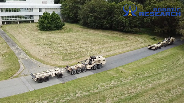
Robotic Research LLC has added Retrotraverse to its AutoDrive-M autonomy kit. The autonomy kit is equipped on the U.S. Army’s Palettized Load System (PLS) logistics trucks.
Robotic Research demonstrated the Retrotraverse capabilities with three of the U.S. Army’s PLS trucks, each towing trailers. “This is a major step forward for our company and has broad application both in autonomy and platooning. The capability solves the potentially life-threatening problem of an autonomous platoon of military vehicles being unable to navigate out of a dangerous situation,” said Alberto Lacaze, president of Robotic Research. “This automated platooning capability will ultimately extend the reach of soldiers without putting them in harm’s way.”
The Retrotraverse feature allows a platoon of heavy-duty trucks with trailers to autonomously reverse. Several autonomous vehicle providers in the trucking industry are demonstrating platooning in benign conditions, where the weather is ideal and road surfaces are smooth and marked.
Robotic Research has been specifically focusing on addressing the edge cases, such as poor weather, dust and off-road conditions, to ensure a robust autonomous system that is necessary for operating in all conditions and during mission-critical operations for the military.
If a platoon drives into a dead end, or similar edge case where it cannot make a U-turn, the platoon of vehicles with trailers needs to be able to reverse out of the situation. Retrotraverse can make this happen.
“Anyone who has backed up a truck with a trailer knows how difficult it is to navigate,” said Joe Putney, director of commercial systems at Robotic Research. “The autonomous Retrotraverse feature was able to reverse a truck and trailer faster than even our most skilled drivers. This feature is not just lifesaving, it’s time-saving, and it has the ability to reduce one of the greatest pains truck drivers have.”
In 2018, Robotic Research was awarded a three-year, $49.7 million contract by the U.S. Army to provide its autonomy kit for large convoy resupply vehicles. Robotic Research has since delivered nearly 100 unmanned platooning trucks.
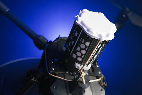
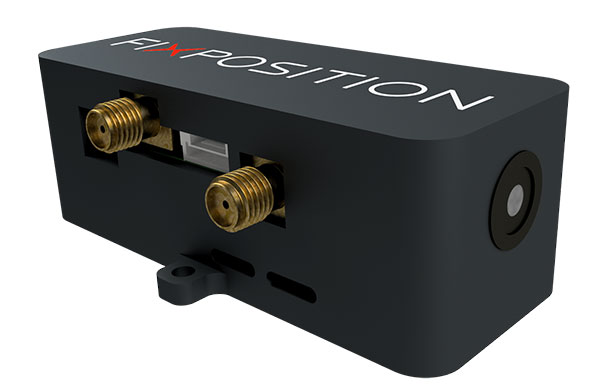
Vision-RTK enables applications in previously unreachable areas and unlocks new possibilities for autonomous ground robots and drones
At this year’s Intergeo Digital event, taking place Oct. 13-15, Fixposition is debuting the Vision-RTK positioning sensor, a compact centimeter-accurate solution with high reliability and availability in environments that are challenging for traditional GNSS.
Photo: FixPosition
The Vision-RTK’s sensor-fusion algorithm is based on the deep integration of satellite, camera and inertial sensors, and enables unprecedented reliability and availability in diverse and challenging applications, the company stated.
“The highly integrated nature of our Vision-RTK sensor and our deep expertise in computer vision and real-time kinematic (RTK) GNSS enabled us to implement completely new approaches in sensor fusion, resulting in previously unseen performance,” said Lukas Meier, CTO and co-founder of Fixposition.
Traditional GNSS sensors suffer from limited reliability in GNSS-challenging and denied areas. On the other hand, standalone computer vision is sensitive to light conditions (such as snow, strong sunlight and rain) and struggles in situations where there is a lack of features such as cornfields and grass. Errors accumulate over time with standalone inertial technology, causing large drifts.
As a result, devices using either sensor are limited in their range of operation and are likely to fail in certain conditions. Fixposition’s solution increases the potential of these sensors with its unique sensor-fusion technology by increasing the trustworthiness of the positioning accuracy and the range of operation in different environments.
The real-time sensor fusion provides centimeter-accurate absolute positioning at any time, in any outdoor environment. This small module integrates two RTK-GNSS receivers and visual inertial navigation, and is suitable for applications where size and accuracy are of paramount importance.
The dual-receiver configuration, together with Fixposition’s advanced algorithms, provides a true-heading output and increased resistance to electromagnetic radiation.
The sensor provides USB and Wi-Fi connectivity and a web interface. It enables straightforward integration in state-of-the-art autopilot control systems for drones and robots. It’s also plug-and-play compatible with platforms such as PX4, ROS and Apollo.
For ground robotics and drones applications, Vision-RTK increases the device uptime and efficiency while enabling new market segments in areas previously inaccessible. For end-device manufacturers, this technology eliminates the need for an in-house development of advanced localization solutions, shortening their sales cycle and reducing costs and investments.
Visit the Fixposition booth and meet the team at Intergeo Digital 2020 to learn more about the Vision-RTK sensor.
According to a report by InForGrowth, the global GPS tracking devices market was valued at $1,567 million in 2018 and is expected to grow at a CAGR of 12.2% during the forecast period 2026.
Increasing demand for fleet telematics and affordable prices of GPS tracking devices are expected to drive the growth of the GPS tracking devices market.
However, the report says, environmental obstacles and non-standard products are expected to impede the growth of the market in the coming years.
The growth of the GPS tracking devices market is attributed to the increasing demand for fleet telematics in the transportation and logistics sector. Government authorities are making rules and regulations for fleet tracking systems in commercial vehicles for improving the safety of passengers, the report said. In addition, vehicle rental companies are deploying an increased number of GPS tracking devices in their fleets.
Next, technological advancements such as self-driving vehicles and connected car technology mainly rely on GPS-based tracking systems for improving the accuracy and reliability of navigation. According to the report, many developing countries, such as India, are focusing on the advancement of their navigation technology. The adoption of 5G communication technology will also help in the advancement of driverless cars technology, which uses GPS tracking devices for movement and route planning.
Finally, the affordability of GPS tracking devices has encouraged market growth, the report said. This in turn has increased competition between manufacturers to develop updated technology-enabled GPS tracking devices.
Via, a provider of digital infrastructure for public mobility systems, has acquired Fleetonomy, a developer of fleet management software.
Fleetonomy was founded in 2017 by CEO Israel Duanis and CTO Lior Gerenstein, with the vision of building the next generation of fleet management and optimization platforms, suitable for the challenges and opportunities that came with the shift to fleet-based on-demand services.
According to Via, the purchase accelerates its expansion beyond public transit and strengthens its ability to meet increasing global demand for efficient, flexible solutions for logistics and delivery.
Via’s technology is currently used in more than 150 cities and transit operators across the globe to power intelligent transit and delivery platforms, Via said. The need for essential transit and goods delivery has continued to grow during the COVID-19 pandemic, and Via plans to apply Fleetonomy’s technology and expertise in demand prediction and fleet utilization to advance its digitally-powered logistics solutions.
“As we continue to build the next generation of public transportation and delivery infrastructure, we are proud to partner with Fleetonomy to step into this new phase of growth,” said Via Co-Founders Daniel Ramot and Oren Shoval. “We have been consistently impressed by Israel, Lior and the entire Fleetonomy team, and by the beautifully-designed and exceptionally-engineered products they have created. We share a vision for the future of mobility and look forward to realizing this vision together.”
Bynav Technology Co. Ltd. has released the C1 GNSS RTK OEM receiver and the A1 industrial-grade IMU-enhanced GNSS OEM receiver based on Bynav GNSS baseband ASIC Alita and RFIC Ripley. Bynav supplies GNSS high-precision receivers to the Chinese vehicle driver-testing market.
The C1 GNSS RTK OEM receiver board measures 46 × 71 mm and supports dual-antenna heading and full-constellation, including GPS, BDS, Galileo, GLONASS, QZSS, NavIC and SBAS, as well as providing enhanced interfaces like UART serial port, Ethernet, 3 EVENT_IN, 3 EVENT_OUT, 1PPS and CAN bus for easy integration with an external inertial measurement unit (IMU), odometry, lidar or visual SLAM.
The A1 GNSS/INS OEM receiver, measuring 46 × 71 mm and weighing 25 g, is integrated with an industrial-grade IMU (gyro 2.7deg/hr) with an embedded, deeply coupled GNSS+INS algorithm engine as well as tilt measurement algorithm to provide stable, high-precision position and attitude even in the event of GNSS outages.
Most of the vehicle driver testing centers in China have automated their exams with the assistance of GNSS high-precision positioning. As a strategic partner of Duolun Technology, China’s driver-testing system integrator, thousands of drivers testing vehicles equipped with Bynav GNSS RTK receivers are moving around China every day.
The R&D team of Bynav has taken part in the construction of China BeiDou Satellite Navigation System since 2002. With a powerful and experienced GNSS experts’ team and large-scale scenario verification on dynamic driver-testing vehicles, Bynav has successfully developed the high-precision GNSS baseband ASIC Alita and the RFIC Ripley which have been now integrated in the A1 and C1 products.
The performance of the A1 and C1 have been verified and recognized by many domestic customers in the field of vehicle driver testing and autonomous driving.
“We are committed to developing intelligent driving vehicles and commercializing them as soon as possible, in which the GNSS/INS receiver plays an important role to provide absolute position,” said Ying Long, deputy general manager of the Changsha Intelligent Driving Institute, a well-known autonomous driving company in China. “That’s why I started work together with Bynav for a cost-effective and high-performance positioning solution. Currently, the Bynav’s GNSS/INS receivers have been used in our unmanned sweepers, self-driving trucks and other products, and it comes out that the A1 performance is comparable to the world-class and high-end products we used.”
Both receivers support dual-antenna heading and full-constellation and full-frequency tracking (including BDS-3 and L5), and provide SD card interface for raw data storage.
Both C1 and A1 are now available for direct purchase. For wholesale price, contact [email protected].
An autonomous ship launched Sept. 16 on a mission to traverse oceans and gather vital environmental data, guided by GNSS and inertial measurement units (IMUs).
Ocean research non-profit ProMare joined with IBM on the Mayflower Autonomous Ship (MAS) — an artificial intelligence (AI) and solar-powered marine research vessel. Following two years of design, construction and training of its AI models, the fully-autonomous trimaran was launched from Plymouth, England.
The ship is guided by both GNSS and IMU technology. It uses two Hexagon | Veripos LD8 receivers, each with two V560 marine antennas. The onboard IMUs include an iXBlue Octans and two Silicon Sensing AMU30s.
Designed to provide a safe, flexible and cost-effective way of gathering data about the ocean, the new-generation Mayflower promises to transform oceanography by working in tandem with scientists and other autonomous vessels to help understand critical issues such as global warming, micro-plastic pollution and marine mammal conservation.
ProMare is coordinating the scientific studie,s working with IBM Research and leading scientific organizations.
MAS features an AI captain built by ProMare and IBM developers that gives MAS the ability to sense, think and make decisions at sea with no human captain or onboard crew. The new class of marine AI is underpinned by IBM’s latest advanced edge computing systems, automation software, computer vision technology and Red Hat Open Source software.
“Able to scan the horizon for possible hazards, make informed decisions and change its course based on a fusion of live data, the Mayflower Autonomous Ship has more in common with a modern bank than its 17th century namesake,” said Andy Stanford-Clark, Chief Technology Officer, IBM UK & Ireland. “With its ability to keep running in the face of the most challenging conditions, this small ship is a microcosm for every aspiring 21st century business.”
Artie — short for Artemis and artificial Intelligence — is a stowaway hitching a ride on the Mayflower who answers questions about the ship, the ocean or himself on mas400.com. (Photo: IBM)
Interactive web portal follows voyage
To enable followers around the world to stay updated with MAS as it undertakes its various missions, IBM and ProMare have also launched an interactive web portal. Built by IBM iX (the business design arm of IBM Services), the MAS400 portal is designed to provide real-time updates about the ship’s location, environmental conditions and data from its various research projects.
Live weather data is streamed from IBM’s The Weather Company, as MAS receives forecast data and insight from the new IBM Weather Operations Center.
‘Octopus’ aboard answers questions
The portal even features a seven-armed, stowaway octopus chatbot called Artie, who claims to be hitching a ride on the ship. (With seven arms, he’s technically a septopus.) Powered by IBM Watson Assistant technology and created in partnership with European startup Chatbotbay, Artie has been trained to provide information about MAS and its adventures in a lively, and accessible format.
“MAS400.com is one of the most advanced ocean mission web portals ever built,” says Fredrik Soreide, Scientific Director of the Mayflower Autonomous Ship project and Board Member of ProMare. “Protecting the ocean depends on our ability to engage the public in important matters affecting its health. This MAS400 portal is designed to do exactly that and tell people where the ship is, what speed it’s travelling at, what conditions it’s operating in and what science we are conducting. Users can even help Artie the Octopus fish out surgical masks, cigarette butts and other increasingly common forms of ocean litter from a virtual ocean of facts and data.”
MAS will spend the next six months in sea trials and undertake various research missions and voyages before attempting to cross the Atlantic in Spring 2021. MAS’s transatlantic voyage will be based on a similar route and pioneering spirit to the 1620 Mayflower which made the same crossing 400 years ago.
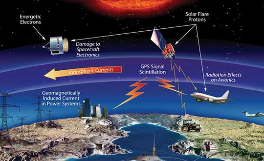
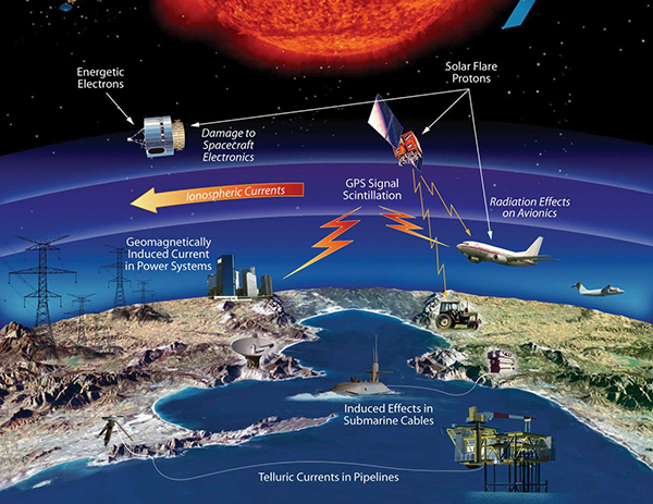
The effects of space weather on critical Earth systems. (Image: NASA)
The United States Congress has passed bipartisan legislation to address how the government deals with threats posed by emissions from the Sun to critical infrastructure such as GPS.
The Promoting Research and Observations of Space Weather to Improve the Forecasting of Tomorrow (PROSWIFT) Act S.881 now awaits signature by the president.
The bill sets forth provisions to improve the ability of the United States to forecast space weather events and mitigate its effects.
It provides statutory authority for the National Science and Technology Council’s Space Weather Operations, Research, and Mitigation Working Group, which coordinates executive branch efforts to understand, prepare, coordinate, and plan for space weather.
The bill directs the Office of Science and Technology Policy, National Oceanic and Atmospheric Administration (NOAA), National Science Foundation, Air Force, Navy, National Aeronautics and Space Administration (NASA), National Security Council, and Federal Aviation Administration (FAA) to carry out specified space weather activities.
The legislation
assigns roles and responsibilities to agencies involved in space weather research and forecasting
ensures agency coordination to better predict severe space weather events and mitigate impacts
calls for coordination between the government and the non-governmental space weather community including academia, the commercial sector and international partners.
Senators Gary Peters (D-MI) and Cory Gardner (R-CO) introduced the first version of the bill in 2016 and a successor passed the Senate in 2017. Reps. Ed Perlmutter (D-CO) and Mo Brooks (R-AL) shepherded it through the House, which passed it Sept. 16.
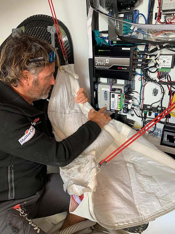
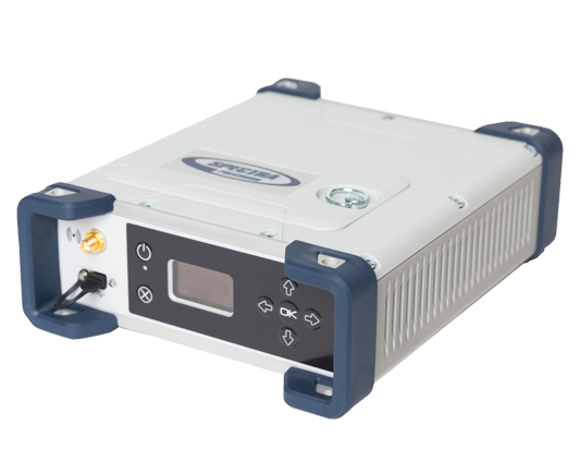
The Spectra Geospatial SP90m GNSS receiver will guide the racing yacht Maître CoQ for the 2020 Vendée Globe, single-handed, non-stop around-the-world yacht race. The Vendée Globe is an extreme endurance test for both sailor and boat and widely considered the ultimate challenge in ocean racing. The race starts Nov. 8 and is expected to finish in late January or early February.
The SP90m will provide the skipper of the Maître CoQ, Yannick Bestaven, with precise position and boat heading information. The SP90m information is integrated to a separate attitude information source, and the entire package of the position, heading and attitude is sent to the boat’s autopilot.
Photo: Spectra Geospatial
Bestaven, responding to the changing sea and wind conditions, strategically adjusts the autopilot to keep the boat moving at top speed to the desired destination as he changes and trims sails and trims foils to achieve maximum sailing efficiency.
The Maître CoQ is an advanced design mono-hull foiling sailing yacht in the category of IMOCA (International Monohull Offshore Class Association) which have a fixed length of 18.28 meters (60 feet), Antoine Connan, head of engineering for the Maître CoQ racing team, selected the SP90m.
The hostile environment and requirements for precise position information at sea far from land made the selection of the SP90m an important technical choice. It always delivers an accurate position and precise heading with no GNSS corrections.
Commenting on the performance of the SP90m in the recent July 2020 2,800-mile qualifying race, the Vendée- Arctique-Les Sables D’Olonne, Connan reports, “We are already very happy with its installation on board.”
The SP90m is a rugged design for marine environments. With 480-channel tracking and dual GNSS antenna inputs, the SP90m is an integrated onboard rover receiver offering minimal size and low power consumption.
When the Maître CoQ technical team, based in La Rochelle, decided they needed to upgrade the boat’s navigation system, they contacted Cadden, a specialist in supplying advanced electronic precision measurement sensors. In addition to the requirement for delivering fast, precise position and heading data, the new sensor had to be lightweight, small, require little power, be easy to integrate, and flawlessly withstand a hostile saltwater environment. Cadden’s analysis concluded the Spectra Geospatial SP90m fit the spec perfectly.
“We are thrilled that the Maître CoQ racing team selected the Spectra Geospatial SP90m,” said Olivier Casabianca, vice president Spectra Geospatial. “It’s one more confirmation that Spectra Geospatial provides truly the highest quality rugged and precise GNSS receivers.“
About the Vendée Globe 2020. Held every four years, the Vendée Globe is a single-handed (solo) non-stop yacht race around the world without assistance. It starts and finishes in Les Sables-d’Olonne in the Département of Vendée in France. The course is a circumnavigation from Les Sables- d’Olonne, that heads south in the Atlantic Ocean to the Cape of Good Hope, then east in the Southern Ocean clockwise around Antarctica, keeping Australia’s Cape Leeuwin and South America’s Cape Horn to port (to the left); and then back north in the Atlantic returning to finish in Les Sables-d’Olonne.