Innovate UK, the United Kingdom’s innovation agency, has selected Hexagon’s Geospatial division to conduct a research project that will result in faster and higher-precision mapping of railway infrastructure through the use of artificial intelligence.
The project is funded by Network Rail, the owner and operator of Great Britain’s railway infrastructure, under its R&D portfolio and delivered by Innovate UK through the SBRI competition, Innovation in Automated Survey Processing for Railway Structure Gauging, Phase One. A small group of teams was selected for this effort.
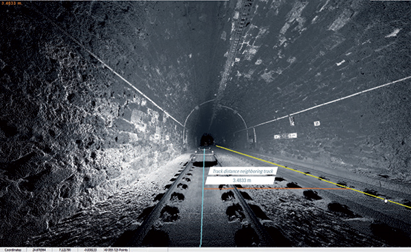
Image: Hexagon
The project will enable Network Rail to automatically identify and measure railway structures from lidar data, saving valuable time and resources, while also improving planning and operations across the rail network. The current, manual process takes analysts months or even years due to the size of the data and the labor-intensive tasks involved.
“The combination of cross-sectional area, shape, length and speed all place a space requirement on today’s railway,” said James Sweeney, senior engineer at Network Rail. “We anticipate this project will offer us a more efficient way to capture, analyse and measure railway features along 20,000 miles of track, which is important to railway safety and the growth and capacity of our network.”
Network Rail collects detailed information about its track and the surrounding features, such as bridges and tunnels. The data is then analyzed to assess clearances between trains and the infrastructure around them, which is key to safety.
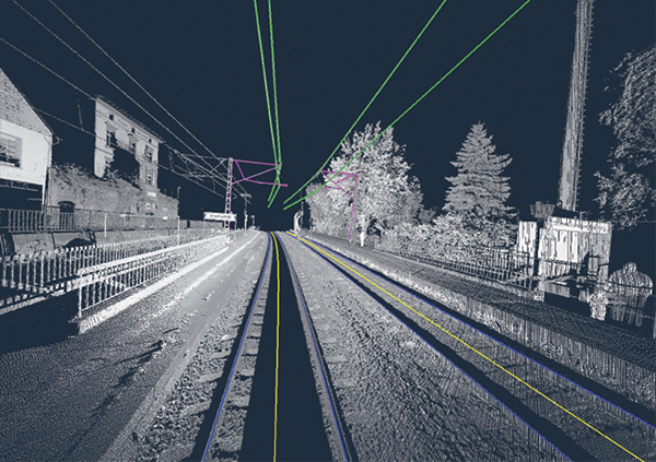
Image: Hexagon
The new project aims to automate the extraction and calculation of railway features from sensor data, leveraging AI to automatically analyze point-cloud data, identify different structure types, and perform measurements on the structures. The data will be collected from reality capture solutions from Hexagon’s Geosystems division.
“Network Rail, supported by Innovate UK, is leading the way in the use of AI to automate rail structure identification and measurement,” said Mladen Stojic, president of Hexagon’s Geospatial division. “We are excited to be part of a project that can help transform the gauging process for UK railways.”
A GNSS jamming trial will take place from Sept. 8 through Dec. 4 in and around Luce Bay, at Wigtownshire in southern Scotland, conducted by the United Kingdom’s Civil Aviation Authority.
The trial will affect electronic situational awareness devices, UAS command systems and GNSS receivers.
The activity may affect GNSS receivers along with UAS and cockpit devices operating on 433, 868, 915, 2400, 5800 MHz operating up to 40,000FT AMSL within 55NM of 545020N 045548W (West Freugh).
During the trials, impacted systems may suffer intermittent or total failure. Individual events will not exceed two minutes in duration with no more than five events per hour. Activity will take place in the daytime hours between 0830 and 1600.
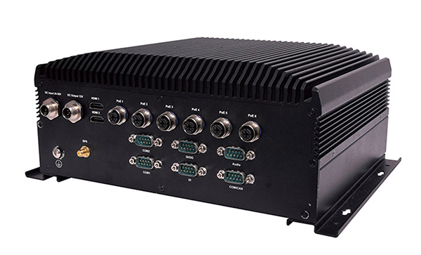
Lanner Electronics Inc., a designer and manufacturer of network appliances and intelligent edge computing platforms, has launched the R3S series of rugged, EN-50155-certified fanless vehicle/rail computers.
The R3S is equipped with a u-blox NEO-M8N module, which receives GPS, Galileo, GLONASS and BeiDou with the default set for GPS + GLONASS dual band.
Powered by Intel Atom x7-E3950 processor (formerly Apollo Lake) and Intel HD graphics 505 processor, R3S series offers power-efficient performance for consolidating the in-vehicle workloads such as video surveillance, control/monitoring, passenger information, and Wi-Fi hotspot sharing.
To ensure proper operations in moving vehicles, R3S series is certified with EN50155, EN50121-3-2, EN50121-4, EN50125-3 and EN45545 standard, E13 standard and has passed MIL-STD-810G shock and vibration resistance certifications. R3S series can operate under wide operating temperature range (-40~70° C) and 24~36/72~110 voltage input, indicating its excellent reliability in harsh railway settings.
Designed for in-vehicle surveillance, the new R3S series equip with 6x M12-protected PoE ports (any 3 or 4 ports can support IEEE 802.3at PoE+) for IP camera or wireless access point connection and one external removable 2.5-inch HDD/SSD drive bay for recorded footage storage.
For edge-to-cloud connectivity, R3S uses its internal GPS/GLONASS chipsets for GPS tracking and has two M.2 slots with up to 4x SIM card readers for failover LTE connection.
For consolidating the in-vehicle workloads such as in-vehicle control/monitoring and passenger information, R3S features a variety of I/O support, including 2x HDMI, DI/DO, 3x COM/CAN BUS and 4xUSB ports.
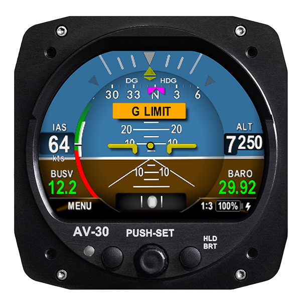
UAvionix Corporation’s aircraft AV-30-C panel display has received STC (Supplemental Type Certification) approval from the U.S. Federal Aviation Administration. The AV-30-C offers pilots an effective and affordable altitude indicator (AI) or directional gyro (DG) replacement with additional features.
AV-30-C is installable as either an AI or DG and adds a suite of in-flight information to the panel out of the box, including GPS navigational data, a probeless angle of attack indicator, baro-corrected altitude, indicated/vertical/true airspeed, non-slaved heading, bus voltage, G load and more with additional features to be announced.
AV-30-C is designed to fit into nearly any aircraft with a three and one-eighth inch round instrument slot without cutting or modifying the panel. By mounting from behind the panel, AV-30-C preserves the aircraft’s original classic look while bringing the latest that modern avionics has to offer to the panel.
The AV-30-C STC provides authorization to install in FAR Part 23 Class 1 and Class 2 aircraft (singles and twins weighing less than 6000 lbs) that are listed on the AV-30-C Approved Model List (AML), containing 635 Aircraft models including Cessna, Piper, Beechcraft, American Champion, Maule, Boeing, Swift, Mooney, Aviat and others. The full AML is available at uAvionix.com/AV-30.
AV-30-C works as a single primary instrument or by installing two units, one as an AI and another as a DG. The aircraft’s original failure-prone vacuum pump system can be removed to further benefit from a fully digital primary instrument cluster.
AV-30-C extends its functionality outside the cockpit as the companion to tailBeaconX, the latest 1090/ES ADS-B transponder with Aireon support for worldwide use and future mandated airspaces. Upon tailBeaconX TSO certification, AV-30-C can double as tailBeaconX’s control interface, allowing the pilot to set the mode and squawk easily, while maintaining AV-30’s existing feature set. tailBeaconX with AV-30-C removes the need to drill additional holes in the airframe to satisfy requirements in countries outside the U.S. and keeps installation costs to a minimum.
“uAvionix is creating avionics with fundamental engineering advantages,” said COO, Ryan Braun. “These are beautiful, no-compromise certified avionics designed to deliver an affordable total cost of ownership. The AV-30-C provides an innovative probeless angle-of-attack and non-slaved directional gyro, both designed to dramatically lower the cost of installation without compromising performance. Where other avionics seem designed to be replaced, the AV-30-C will get better with age. We’re actively developing ADS-B In, electronic flight bag, transponder, and autopilot integrations to ensure AV-30-C becomes an indispensable instrument for every panel.”
AV-30-C will support third-party autopilot systems via the APA-MINI adapter, interfacing AV-30’s heading bug with legacy autopilots. The APA-MINI autopilot adapter is expected to be released in early 2021, with more advanced autopilot integrations to follow.
Recent GPS World webinars have focused on a variety of proven, resilient technologies to combat GNSS and positioning, navigation and timing (PNT) vulnerabilities in critical infrastructure.
Now a Sept. 17 GPS World webinar focuses on how PNT monitoring can further protect critical systems from these vulnerabilities through continuous monitoring and improvement.
The Orolia-sponsored webinar is free. It is scheduled for 1 p.m. EDT / 10 a.m. PDT / 7 p.m. (1900h) Central European Time. Register here.
Protecting critical infrastructure is now a national priority for the U.S. and allied countries. Similar to cybersecurity for network systems, effective GNSS and PNT protection involves identifying and monitoring weak entry points, knowing where and when an intrusion occurs, and providing data about new threats to help strengthen the system going forward. Its value applies across all critical infrastructure sectors such as telecom, power grids and data centers.
Webinar speakers include:
John Fischer Vice President, Advanced R&D, Orolia
For more than 15 years, Fischer has been part of Orolia where he works with global navigation satellite systems, wireless, positioning navigation and timing, as well as specialized systems for its customers. Prior to joining Orolia, he specialized in wireless telecom as a founding member of two startups: Aria Wireless in 1990 and Clearwire Technologies in 1997. At Clearwire, he served as chief technology officer in creating wireless broadband equipment for internet connectivity. Early in his career, Fischer worked as a systems engineer in radar, EW, and command and control systems at Sierra Research and Comptek Research. He holds master’s and bachelor’s degrees in electrical engineering and computing engineering from the State University of New York at Buffalo.
Tim Frost Strategic Technology Manager, Calnex Solutions
Tim Frost is a specialist in next-generation synchronisation techniques, having worked with Zarlink Semiconductor, Symmetricom and now Calnex Solutions on packet-based synchronisation technologies. He is an active contributor to the ITU-T, and has also contributed to the AVnu Alliance, Small Cell Forum, Metro Ethernet Forum and IETF. He has a BSc. in Electrical and Electronic Engineering from the University of Leeds, and a MSc. in Computer Systems Engineering from the University of Manchester.
Francisco Girela Americas Tech Responsible, Seven Solutions
Francisco Girela is the Americas Tech Responsible at Seven Solutions. He holds a Master’s degree in Telecommunications Engineering from the University of Granada. After some time in the private sector, Francisco joined the Timing Keepers group at the same university as a researcher. During his research, he specialized in ultra-accurate time transfer systems and he focused on the development of the White Rabbit technology. He combines his work for Seven Solutions with his studies for a Ph.D. in Telecommunications Engineering. This combination has provided Francisco with a strong technical background on high-accuracy time synchronization and deep knowledge on timing applications in industrial sectors.
Automotive technology company Veoneer Inc. and Qualcomm Technologies Inc. are working together to deliver scalable advanced driver-assistance systems (ADAS) and collaborative and autonomous driving (AD) solutions.
The platform will integrate Veoneer’s fifth-generation perception software and driving policy software with the current and future Snapdragon Ride portfolio.
Qualcomm Technologies intends to make this integrated SoC and software stack platform available to global automakers and Tier-1 suppliers.
Designed for Tier-1 automakers
The solutions will be powered by Veoneer’s next-generation perception and driving policy software stack and the Qualcomm Snapdragon Ride ADAS/AD scalable portfolio of systems on a chip (SoC) and accelerators. They solutions range from L1 to L4 systems, designed to create an open platform for Tier-1 suppliers and automakers.
Designed to address the growing complexities associated with developing ADAS, including safety compliance, the integrated software and SoC platform aims to address the growing needs of the automotive ecosystem for scalable and upgradable solutions, which require highly advanced and power-efficient compute, connectivity and cloud service capabilities across all vehicle tiers.
Veoneer will serve as a Tier-1 system integrator for the new solution, while continuing its current strategies, which include developing, selling and launching its full line of ADAS and collaborative driving products and systems.
2024 model vehicles
The open and programmable platform that both companies intend to develop will be designed to create alternatives for automakers and Tier-1s for more customization opportunities while also charting a course for next-generation automotive architecture evolution. The companies expect the integrated platform to be available through automotive Tier-1 suppliers or directly to OEMs for 2024 vehicle production.
Veoneer’s software stacks are automotive grade solutions designed to meet the requirements of automakers, regulators and rating agencies globally. It has received top performance ratings and enabled automakers to achieve 5-star safety ratings for European New Car Assessment Program (Euro NCAP) in 2018 and 2020.
The companies plan to launch a state-of-the-art automotive-grade, functional safety compliant and optimized platform, which will include a full range of optimized NCAP features and up to hands-free driving on highways and slow-moving traffic. The platform will be continuously upgradeable through over-the-air updates.
The next-generation software stack will be developed in a dedicated organization within Veoneer.
In January, Qualcomm Technologies announced its latest addition to the company’s growing portfolio of automotive products with the new Qualcomm Snapdragon Ride platform.
The Federal Aviation Administration (FAA) plans to evaluate technologies and systems that could detect and mitigate potential safety risks posed by unmanned aircraft. The effort will be a part of the agency’s Airport Unmanned Aircraft Systems Detection and Mitigation Research Program.
The FAA Reauthorization Act of 2018 requires the agency to ensure that technologies used to detect or mitigate potential risks posed by unmanned aircraft do not interfere with safe airport operations.
The FAA plans to test and evaluate at least 10 technologies or systems. The evaluations are expected to begin later this year and will initially occur at the FAA’s William J. Hughes Technical Center, located next to the Atlantic City International Airport in New Jersey.
After the initial testing and evaluation in New Jersey, the agency expects to expand the effort to four additional U.S. airports. Those selections will be made at a later date.
According to the FAA, interested manufacturers, vendors and integrators of drone detection and/or mitigation technologies/systems will have 45 days to respond to its announcement.
In addition, the FAA expects to issue another solicitation in the coming weeks for airport operators interested in hosting the additional research and testing.
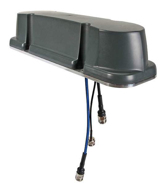
Huber+Suhner extends its Sencity rail MIMO antenna portfolio with dual-band GNSS services
Huber+Suhner, an international manufacturer of components and systems for optical and electrical connectivity solutions, has extended the capabilities of its rail rooftop antennas with its launch of an embedded dual-band GNSS antenna that meets the railway industries’ stringent requirements.
Adding to its established Sencity rail antenna portfolio, the new multiple-input, multiple-output (MIMO) rooftop antenna enables railway operators to improve geospatial positioning and time precision of their operations.
Photo: Huber+Suhner
Supporting both the upper and lower GNSS bands, the antenna enables pinpoint location accuracy for the rigorous applications such as autonomous trains. With greater transparency of movement on the tracks, railway operators can improve the operational planning of densely crowded railway tracks and metro lines.
“The GNSS port on the antenna supports a higher number of satellite constellations,” said Daniel Montagnese, Huber+Suhner product manager for railway antennas. “This enables operators to improve signal acquisition time, as well as reducing the impact of obstructions in order to increase efficiency on the tracks.”
The GNSS port is complemented by two broadband cellular and Wi-Fi compatible ports that can be deployed for a variety of different train-to-ground services.
The Sencity MIMO rail antenna supports the GPS, Galileo, BeiDou and GLONASS constellations. Its robust design also meets the stringent EN 50155 railway standard and is fire retardant according to EN 45545-2 and NFPA130.
Huber+Suhner is a global company with headquarters in Switzerland which develops and manufactures components and system solutions for electrical and optical connectivity. With cables, connectors and systems — developed from the three core technologies of radio frequency, fiber optics and low frequency — the company serves customers in the communication, transportation and industrial sectors.
While connected cars provide wonderful advantages, their integration with cloud connectivity come with a heightened risk for cyber attacks.
Commentary by Alexander Meisel
When it comes to connected cars, automakers are innovating fast. Consumers are experiencing increasing amounts of futuristic features, be they passenger connectivity, automated speed regulation or autonomous driving capabilities.
However, these innovations and their integration with cloud connectivity come with a heightened risk for cyber attacks. A recent study conducted by U.K. self-driving hub organization Zenzic found that becoming cyber-resilient will be the biggest technical obstacle to successfully deploy self-driving cars on roads by 2030. This mountain will be a big one to surmount, and it’s only growing in size: The auto industry has seen a 94% year-over-year increase in hacks since 2016.
How can automakers prioritize security while keeping up with the demand for innovation in today’s connected cars?
Carmakers must consider security from day one
To make sure that security is built into the very foundations of a car, automakers must make it a priority from the first day of design. This focus is lacking amongst carmakers at the moment. In fact, 19% respondents to one survey said they don’t do enough security testing in the design phase, and only 28% said that they do a lot of the testing during the design stage.
Automakers can use design principles to build in security from the outset. For example, the principle of complete mediation allows for enhanced security as it ensures that a software stem “requires access checks to an object each time a subject requests access.” This means that attackers are only invited to exploit a system on one single occasion due to checks on subjects’ permissions.
Carmakers can also ensure that they are not sacrificing security by considering its importance when purchasing components from separate suppliers. These components must be specific enough to enable security in the system, but generic enough to allow for innovation.
Automakers must make cybersecurity a priority from the first day of design.
Here, companies can leverage the software engineering principle of interface segregation. This means that a shrunken, clear interface should be supplied by the vendor, so that the customer only uses the methods that are of interest to them.
In turn, this allows systems to remain decoupled and thus easier to then build a rich interface on top of. However, carmakers will have to stay on top of the security of the part in the development phase, and ensure that dormant functions are not abused by at least logging their execution once somebody tries to call them out of context.
Developers and cybersecurity experts must become a core part of the team
Software development is relatively new territory for carmakers. Now, cybersecurity is a key component of building connected cars, and automakers need to embrace developers that have expertise in this area and make them part of the core team.
This cultural change must be championed by the business leaders to allow car security to advance alongside the innovative features that the industry is building. This can be done by implementing DevSecOps ideology into the team, in order to “build the mindset that everyone is responsible for security.”
Car development teams will likely need a group of cybersecurity experts who can educate the rest of the developers and are willing to participate in the development process in order to check and implement safe and secure functions. If a company doesn’t have this kind of expertise in-house, they can partner with an expert third-party to help them along this journey.
Innovation and security can complement each other
Cybersecurity doesn’t mean sacrificing feature innovation: developments are being made in the field of security too, such as biometric technologies that can be integrated into car design.
For example, Blackberry’s QNX technology “has built in concepts for hardware and software trust validation, hypervisor to maintain a separation between the safety critical and infotainment systems, and a core operating system which passes all the functional safety standards,” according to the company’s senior VP SVP, head of QNX, John Wall. Innovation need not suffer at the hands of security, and vice-versa.
Potential AV thieves would first look to use GPS data to disable or falsify a car’s GPS system, making it untraceable.
In addition, the world’s leading electric vehicle provider, Tesla, ensures security in its cutting-edge, connected cars by sending security updates to cars’ operating systems overnight, and even providing awards for hackers that manage to hack its cars.
Looking ahead to the possibilities of autonomous vehicles (AV) that can drive passengers without needing to have their owner inside, innovation in GPS will be necessary to ensure security and accountability of the car. Potential AV thieves would first look to use GPS data to disable or falsify a car’s GPS system, making it untraceable.
However, carmakers can make this impossible for hackers by not just logging the data in its raw form, but also combining it with other car data using cryptographic algorithms. This ensures that the GPS data remains traceable even after the hardware has been taken apart and sold on the auto-parts black market. In this way, the signature of the original data combined with the GPS position adds an additional layer of security.
Integrating security into connected car design is no simple feat, but it’s a necessary one for carmakers that want to ensure the safety of their passengers while on the roads. By using design principles, diversifying expertise within development teams, and understanding that security and innovation need not be a trade-off, they can do just that.
Alexander Meisel is an automotive cybersecurity engineer at intive. He has a computer networking diploma from Hochschule Furtwangen University, and he has served as a CTO and Development Team Director in previous companies. He has experience with venture capital, successful M&As, and product and technical marketing strategies. He is also a public speaker at technical conferences and trade shows.
Tallysman Wireless has added a line of AccuAuto vehicle antennas aimed at the autonomous vehicle market.
The compact and rugged embedded AccuAuto antennas offer key features not available in other embedded autonomous vehicles antennas on the market, the company said.
The automobile industry is transitioning from offering GNSS-assisted navigation where the accuracy requirement is ±3 to 5 meters (low-precision GNSS code positioning) to providing driver assistance (such as lane-keeping) and autonomous vehicle navigation where the accuracy requirement is < 0.1 meters (such as high-precision GNSS phase positioning).
Current roof-mounted GNSS antennas on most vehicles provide the accuracy required for navigation but they lack the precision required for assisted driving or autonomous vehicle operation. Tallysman’s new line of AccuAuto antennas are designed to provide strong clean code and phase signals that enable high-precision real-time kinematic (RTK) and precise point positioning (PPP) navigation.
The Tallysman embedded AccuAuto vehicle antenna features a patented Tallysman Accutenna technology multi-constellation and multi-frequency antenna element, an integrated ground plane, radome and underside cover that provides mist and condensation protection.
The bottom cover also supports the antenna cable and mitigates cable vibration to ensure the antenna has a long service life, while the ground plane improves antenna performance.
All AccuAuto antenna electronic components are Automotive Electronics Council (AEC) certified and are designed to perform under challenging environmental conditions, such as extreme temperatures (–40 °C to +125 °C) and continuous shock and vibration.
Signal quality is improved with a deep pre-filter that minimizes out-of-band noise and maximizes in-band reception. This feature enables reliable GNSS signal reception in challenging urban environments, where inter-modulated signal interference from LTE and other cellular bands is common.
The triple-band TWA928 supports GPS/QZSS-L1/L2/L5, GLONASS-G1/G2/G3, Galileo-E1/E5a/E5b, BeiDou-B1/B2/B2a, and NavIC-L5 signals and frequency bands (the TWA928L includes support for L-band correction services).
provide a better understanding of the activity, uses, users and broader beneficiaries of the National Geodetic Survey’s Aeronautical Survey Program,
help define its socio-economic benefits,
provide preliminary order of magnitude estimates of benefits of the program, and
examine influences on future needs for the program’s services.
The footprint (trade space) analysis presents data on airport improvement grants, activities of the program, airports, aviation and societal beneficiaries. Methods of estimating socio-economic benefits are considered, preliminary estimates of benefits are made and issues that will affect use of the services in the future are discussed. Additional information is included in 10 appendices.
The FAA Airport Improvement Program (AIP) provides grants, to public agencies for planning and development of the 3,249 eligible public-use airports and the 72 privately owned civil airports.
The FAA requires that geographic information system (GIS) contractors submit plans and surveys with geodetic control, runway, navigational aid, obstruction and other aeronautical data under its Airports GIS (AGIS) program. These contracted survey plans and surveys are sent to the NGS Aeronautical Survey Program (ASP) for quality assurance review.
The GIS information is used by the FAA in establishing flight rules and other requirements to assure safety.
Irv Leveson is an economist with extensive experience examining GNSS markets, applications, benefits and policies. His public studies include: “The Economic Benefits of GPS.” He recently led a National Geodetic Survey study.
Using RTK’s pinpoint-level location data in the Verizon network is a building block to bring to scale emerging technologies such as driverless city zones, expansion of precision agriculture and drone delivery.
Verizon has launched what it calls hyper-precise location using real-time kinematics (RTK) to provide accuracy within one to two centimeters on the Verizon network.
Verizon has built and deployed RTK reference stations nationwide so that compatible internet of things (IoT) devices can receive the higher accuracy. Verizon is working to make RTK accessible with myriad device makers.
RTK will also support emerging technologies that depend on high-level location accuracy, such as delivery drones and customer-approved location data for first responders in emergencies.
RTK technology reduces the cost and risk associated with inaccurate location data, Verizon said in a press release. “Billions of IoT devices across a multitude of industries will benefit from improved location accuracy, with hyper-precise location information enabling a host of new services.
“For instance, robotics at distribution centers will be able to perform more efficient, accurate and safe logistics operations. More accurate positioning can help speed deployment of high-value assets in emergency situations to the precise location, and more precise tracking of emergency equipment can provide faster redeployment in disaster response scenarios.”
The rollout of its hyper-precise location services along with Verizon’s 5G Ultra Wideband network and 5G Edge will pave the way for more autonomous technologies, the company said.
“We are scaling RTK to enable mobile location accuracy to within a few centimeters, transforming what is currently possible when it comes to location-enabled services and new IoT solutions coming onto the market,” said Nicola Palmer, chief product development officer for Verizon. “Continued growth in the IoT environment means billions of devices in fields where precision location services are becoming more critical, such as vehicle automation, unmanned aerial vehicles, precision agriculture technology, infrastructure monitoring, asset tracking and high-value shipping.”
Image: 4X-image iStock / Getty Images Plus / Getty Images
Reimagining road safety
In partnership with HERE Technologies, Verizon is building next-generation technologies for vehicle and pedestrian safety using hyper-precise high-definition mapping and RTK.
This work paves the way for connected services that are designed to drive road safety improvements. By creating a vehicle-to-network (V2N) communication system equipped with hyper-local location accuracy, collision avoidance applications can precisely identify vehicles, pedestrians and bicycles, and relay the information through Verizon’s 5G Edge and HERE’s AI to predict likely travel paths and warn vehicles of impending potential collisions. This partnership is one of multiple recent initiatives Verizon has taken to increase road safety.
“Moving beyond the static fidelity of satellite-based location data enables an exciting new generation of connected, autonomous experiences,” said Jørgen Behrens, SVP, chief product officer at HERE Technologies. “By pairing HERE’s live, hyper-precise HD Map and HD Positioning technologies with intelligent RTK algorithms, and making that scalable, Verizon is putting a transformative level of location insights into the hands of developers and consumers alike.”
Powering the autonomous future
Hyper-precise location accuracy will be critical to advancing autonomous driving and together, Verizon and Renovo are ushering in a new era of transformative solutions critical for the future of autonomy on the road. These solutions leverage machine learning and RTK technology, powered by a combination of next-generation solutions such as 5G.
“RTK is a critical technology for advanced driving assistance systems (ADAS). Accurate positioning helps ADAS vehicles navigate better, drive smoother, and react faster to the surrounding environment,” said Christopher Heiser, CEO and Co-Founder of Renovo. “Nationwide, reliable RTK networks make for a viable way to deliver these enhanced capabilities to mass-market cars and trucks. For companies that manage the huge datasets that power next-generation vehicle platforms like Renovo, this is very exciting.”
IoT devices currently using RTK can be accessed and managed through Verizon’s ThingSpace management platform and APIs.