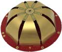
Tallysman Wireless Inc. has added four embedded VeroStar products to its line of GNSS antennas. The compact and light embedded VeroStar models offer key features not available in many other embedded antennas on the market.
Photo: Tallysman
The VSE6028, VSE6028L, VSE6328 and VSE6328L embedded VeroStar antennas are designed and crafted for high-accuracy positioning. With an exceptionally low roll-off from zenith to the horizon, VeroStar antennas provide tracking of GNSS and L-band correction signals at low elevation angles.
The optimized axial ratio at all elevation angles results in excellent multipath rejection, enabling accurate and precise code and phase tracking.
For details on the antenna and its development, see “Innovation” in the September issue.
VeroStar antennas feature a robust pre-filter and high-IP3 LNA architecture, minimizing de-sensing from high-level out-of-band signals, including 700 MHz LTE, while still providing a noise figure of only 1.8 dB.
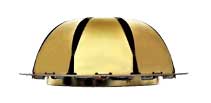
Photo: Tallysman
The light (80 g) and compact (106 mm in diameter and 40 mm in height) wide-band spherical antenna element enables the VeroStar to deliver a ±2 mm phase centre variation (PCV), making it ideal for high-precision applications, such as autonomous vehicle navigation (land, sea and air), smart survey devices, and maritime positioning.
The VSE6028 supports the full GNSS spectrum (the VSE6028L includes support for L-band correction services), while the VSE6328 supports the GPS/QZSS-L1/L2/L5, GLONASS-G1/G2/G3, Galileo-E1/E5a/E5b, BeiDou-B1/B2/B2a, and NavIC-L5 signals and frequency bands (the VSE6328L includes support for L-band correction services).
The unique features of the VeroStar antennas deliver high signal-to-noise ratio (SNR), high accuracy, and high precision in challenging environments.
Cohda Wireless has released an updated version of its C-V2X software development kit (SDK). According to the company, the SDK now features an extensive range of useful applications and tools, as well as a virtual simulation tool. The virtual simulation tool allows users to test their applications before real-life deployment, through high-quality, simulated drives that provide full playback capabilities for actual drive tests.
The Cohda C-V2X SDK is a self-contained virtual machine that allows anyone with previous embedded Linux experience to quickly compile and run C-V2X applications in conjunction with C-V2X development platforms, such as those featuring the Qualcomm 9150 C-V2X chipset solution, the company said.
The SDK includes source code for red light warning and road side alert to demonstrate the various APIs and enable quick application development. It also features binaries for forward collision warning, emergency electronic brake light, curve speed warning, RoadWorks warning, blind spot warning, hazard location warning for China, abnormal vehicle warning for China, speed limit warning for China, red light violation warning for China and green light optimal speed advisor for China. It includes tester control interfaces for performing conformance tests, as well.
“The functional benefits of this SDK, especially the vsim component, have significant tangible value in the C-V2X ecosystem,” said Fabien Cure, chief engineer at Cohda Wireless.
As they are radio agnostic, Cohda’s V2X solutions support C-V2X and dedicated short-range communication.
Approval is given for Arianespace’s Ariane 5 flight on July 31
Arianespace’s fifth mission of 2020 has been given the green light for liftoff following a July 29 launch readiness review conducted at the Spaceport in French Guiana.
The launch will deliver the Intelsat Galaxy 30 (G-30) satellite into orbit. G-30 will become part of the Wide Area Augmentation System (WAAS), the air navigation aid developed by the U.S. Federal Aviation Administration to augment GPS and GNSS.
Besides G-30, the Ariane 5 launch vehicle will also carry the Mission Extension Vehicle-2 (MEV-2) and BSAT-4b. All satellites are flight-ready, along with the Spaceport’s infrastructure and the network of downrange tracking stations.
With approval granted, Ariane 5 also is cleared for rollout on July 30 from its Final Assembly Building to the ELA-3 launch zone. Liftoff will occur on July 31 during a 46-minute launch window opening at 6:30 p.m. local time in French Guiana. To watch the launch live, visit the Arianespace website.
Ariane 5 will deliver a total payload lift performance of approximately 10,468 kg. on the mission to geostationary transfer orbit (GTO), which is designated Flight VA253. This total factors in the three passengers, plus the workhorse vehicle’s multi-payload deployment system and integration hardware.
G-30 and MEV-2 — both produced by Northrop Grumman to serve the operational needs of Intelsat — are stacked together in the upper position of Ariane 5’s payload configuration. G-30 will be deployed first during the 47-minute flight sequence, followed by MEV-2.
To be released last as the mission’s lower passenger, BSAT-4b is being launched by Arianespace as part of a turnkey contract between the Japanese operator B-SAT and the satellite manufacturer, Maxar.
Fibocom, a global provider of internet of things (IoT) wireless solution and wireless communication modules, has reached an agreement with three investment institutions to acquire the automotive embedded module product line of Sierra Wireless through its joint venture company.
The funds will be used to acquire the automotive embedded module assets of Sierra Wireless through Rolling Wireless (H.K) Ltd., the subsidiary of Rolling Wireless Technology Co., Ltd. After the acquisition, the joint venture company Rolling Wireless (H.K.) Limited will operate the global automotive embedded module business independently.
Fibocom signed an agreement with three professional investment institutions — Shenzhen Capital Group Co., Ltd., Shenzhen Jianxin Huaxun Equity Fund Management Co., and Shenzhen Qianhai Red Earth M&A Fund Partnership (Limited Partnership) — planning to jointly increase investment in Rolling Wireless Technology Co., Limited, a joint venture company invested in by the four parties.
According to a Fibocom press release, “As an important milestone in Fibocom’s globalization, this strategic move will strengthen Fibocom’s industrial advantage in the IoT sector and will help to further enhance its global market share in the automotive embedded module business.”
“We have been dedicated to providing high-speed, stable and reliable embedded wireless modules to the IoT industry for more than twenty-one years,” said Zhang Tianyu, chairman of Fibocom. “The acquiring will allow us to dive deeper into the automotive vertical industry and continue to provide more market-oriented high-performance embedded wireless modules and total IoV solutions for global customers in the automotive industry.”
By Alexander Meisel, automotive cybersecurity engineer at intive
Alexander Meisel
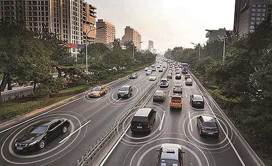
When it comes to connected cars, automakers are innovating fast. Consumers are experiencing increasing amounts of futuristic features, be they passenger connectivity, automated speed regulation, or autonomous driving capabilities.
However, these innovations and their integration with cloud connectivity come with a heightened risk for cyber attacks. A recent study conducted by U.K. self-driving hub organization, Zenzic, found that becoming cyber-resilient will be the biggest technical obstacle to successfully deploy self-driving cars on roads by 2030. This mountain will be a big one to surmount, and it’s only growing in size: The auto industry has seen a 94% year-over-year increase in hacks since 2016.
So, how can automakers prioritize security while keeping up with the demand for innovation in today’s connected cars?
Carmakers must consider security from day one
To make sure that security is built into the very foundations of a car, automakers must make it a priority from the first day of design. This focus is lacking amongst carmakers at the moment. In fact, 19% respondents to one survey said they don’t do enough security testing in the design phase, and only 28% said that they do a lot of the testing during the design stage.
Automakers can use design principles to build in security from the outset. For example, the principle of complete mediation allows for enhanced security as it ensures that a software stem “requires access checks to an object each time a subject requests access.” This means that attackers are only invited to exploit a system on one single occasion due to checks on subjects’ permissions.
Carmakers can also ensure that they are not sacrificing security by considering its importance when purchasing components from separate suppliers. These components must be specific enough to enable security in the system, but generic enough to allow for innovation.
Here, companies can leverage the software engineering principle of interface segregation. This means that a shrunken, clear interface should be supplied by the vendor, so that the customer only uses the methods that are of interest to them. In turn, this allows systems to remain decoupled and thus easier to then build a rich interface on top of. However, carmakers will have to stay on top of the security of the part in the development phase, and ensure that dormant functions are not abused by at least logging their execution once somebody tries to call them out of context.
Developers and cybersecurity experts must become a core part of the team
Software development is relatively new territory for carmakers. Now, cybersecurity is a key component of building connected cars, and automakers need to embrace developers that have expertise in this area and make them part of the core team.
This cultural change must be championed by the business leaders to allow car security to advance alongside the innovative features that the industry is building. This can be done by implementing DevSecOps ideology into the team, in order to “build the mindset that everyone is responsible for security.”
Car development teams will likely need a group of cybersecurity experts who can educate the rest of the developers and are willing to participate in the development process in order to check and implement safe and secure functions. If a company doesn’t have this kind of expertise in-house, they can partner with an expert third-party to help them along this journey.
Innovation and security can complement each other
Cybersecurity doesn’t mean sacrificing feature innovation: developments are being made in the field of security too, such as biometric technologies that can be integrated into car design.
For example, Blackberry’s QNX technology “has built in concepts for hardware and software trust validation, hypervisor to maintain a separation between the safety critical and infotainment systems, and a core operating system which passes all the functional safety standards,” according to the company’s senior VP SVP, head of QNX, John Wall. Innovation need not suffer at the hands of security, and vice-versa.
In addition, the world’s leading electric vehicle provider, Tesla, ensures security in its cutting-edge, connected cars by sending security updates to cars’ operating systems overnight, and even providing awards for hackers that manage to hack its cars.
Looking ahead to the possibilities of autonomous vehicles (AV) that can drive passengers without needing to have their owner inside, innovation in GPS will be necessary to ensure security and accountability of the car. Potential AV thieves would first look to use GPS data to disable or falsify a car’s GPS system, making it untraceable.
However, carmakers can make this impossible for hackers by not just logging the data in its raw form, but also combining it with other car data using cryptographic algorithms. This ensures that the GPS data remains traceable even after the hardware has been taken apart and sold on the auto-parts black market. In this way, the signature of the original data combined with the GPS position adds an additional layer of security.
Integrating security into connected car design is no simple feat, but it’s a necessary one for carmakers that want to ensure the safety of their passengers while on the roads. By using design principles, diversifying expertise within development teams, and understanding that security and innovation need not be a trade-off, they can do just that.
Alexander Meisel is an automotive cybersecurity engineer at intive. Alexander has a Computer Networking diploma from Hochschule Furtwangen University, and he has developed as a CTO and Development Team Director in previous companies. He has experience with venture capital, successful M&As, product and technical marketing strategies. Meisel is also a public speaker at technical conferences and trade shows.
Latest inertial navigation system serves new customer requirements in autonomous vehicles, mobile mapping, surveying and more
Photo: Honeywell
Honeywell is introducing the HGuide n380, an inertial navigation system (INS) that communicates position, orientation and velocity of an object — such as an autonomous vehicle or unmanned aerial vehicle (UAV) — even when global navigation satellite signals are unavailable.
Smaller, lighter and lower priced than previous Honeywell inertial navigation systems, the HGuide n380 is built using Honeywell’s rigorous design standards to withstand harsh environments in the air, on land or at sea.
“We recognized a need for a small, high-performance inertial navigation system in areas like 3D mapping, surveying and other applications where space is at a premium and performance cannot be compromised,” said Chris Lund, offering management senior director, Navigation and Sensors, Honeywell Aerospace. “We responded by developing the HGuide n380 inertial navigation system, which provides our customers with proven, cost effective inertial sensor technology, created for aerospace applications, but that can be integrated into almost any architecture.”
The new inertial navigation system is composed of Honeywell’s HGuide i300 inertial measurement unit (IMU), a GNSS receiver and Honeywell’s proprietary sensor-fusion software, which is based on the algorithms used for navigation on millions of aircraft every day.
Inputs from these components are fused together to determine position, orientation and velocity to deliver critical navigation information even in areas where a satellite signal is degraded or altogether unavailable, such as canyons, bridges, tunnels, mountains, parking garages or dense forests.
“As the industry evolves, Honeywell’s HGuide suite of IMUs and navigators will be a key enabler of emerging segments like autonomous vehicles, mobile mapping, precision agriculture, robotics and surveying,” Lund said.
During its development, the new product was placed in extreme environments to test ruggedness and was exposed to extensive factory calibration and compensation procedures that help ensure measurement accuracy and performance.
Honeywell has extensive experience in designing and building high-end inertial sensor and navigation systems and has used that expertise to develop a lower-cost portfolio of HGuide offerings to serve new markets and customer requirements.
To date, Honeywell has delivered more than half a million high-performance inertial sensors to serve as navigation aids on an extensive list of manned and unmanned vehicles, which include many air and spacecraft in use today.
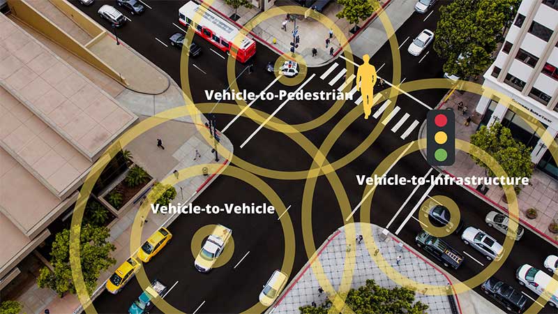
Cohda Wireless has partnered with u-blox to produce an advanced V2X solution for the global Cooperative Intelligent Transport market. With the partnership, Cohda’s V2X software stack will support the u-blox UBX-P3 DSRC/802.11p V2X chip.
Cohda Wireless and u-blox have a long-standing relationship and share a common vision of leveraging wireless technology to reduce the number of road accidents and fatalities across the globe.
The u-blox chip enables wireless vehicle-to-vehicle (V2V) and vehicle-to-infrastructure (V2I) communication, now enhanced with Cohda’s hardware-agnostic software applications.
Cohda said its software is widely deployed in the industry, providing 360° awareness and detecting hidden threats beyond anything a driver or on-board sensors can see.
Cohda Wireless Chief Engineer Fabien Cure said that the partnership offers the market an advanced V2X solution that will be of particular interest to Tier 1 auto makers, OEMs and road authority suppliers.
“In order to progress vehicle safety, OEMs need to produce vehicles that have embedded V2X wireless communication technology as a standard inclusion,” Cure explained. “Likewise, cities around the world are preparing for the introduction of wide scale cooperative intelligent transport systems.”
Cohda’s V2X software is in production vehicles of GM and Volkswagen.
“Connectedness is the key to safer roads and highways around the world and a technology solution of this calibre is an enabler of further trials and development in this sector that we warmly welcome,” added Mr Cure.
“The porting of Cohda’s leading V2X onto our high-performance UBX-P3 chip is an important proof point that both our solutions are interoperable and enable a swift integration into automotive platforms,” said Herbert Blaser, senior director, Product Center Short Range Radio at u-blox.
Cohda’s software products are applied in more than 60 percent of all V2X field trials in the world today in compliance with U.S. Federal Communications Commission and European Telecommunications Standards Institute (ETSI) standards.
“When we connect vehicles to each other and to roadside infrastructure, we are creating an intelligent and integrated road transport system that has the potential to reduce road accidents simply because the technology is capable of things humans aren’t,” added Cure.
Representatives from Fuyao Glass visited Harxon’s Shenzhen, China, headquarters on July 1. (Photo: Harxon)
Fuyao Glass Industry Group Co. Ltd. and Harxon Corporation have established a partnership to develop an advanced smart conformal antenna with automotive glass. Representatives from Fuyao Glass visited Harxon’s Shenzhen, China, headquarters on July 1.
According to the agreement, Harxon will specifically study the pass-through characteristics of high-frequency signals, and develop revolutionary automotive antennas based on the material and manufacturing craftsmanship of Fuyao Group automotive glass.
Both parties will establish a joint innovation team to research and develop a smart, multi-band conformal automotive antenna that integrates radio services with Fuyao’s smart automotive glass technology.
By combining the automotive glass and the antennas into one package, automakers capture immediate benefits of cost reduction, reduced installation complexity, and improved reliability.
Founded in 2008, Harxon Corporation (a BDstar company) is a customer-focused enterprise carrying out innovative research, manufacturing and marketing in high-precision GNSS antennas, ultra-reliable wireless data transmission radio modems, and smart antennas. Applications include surveying, precision agriculture, UAVs and automotive vehicles.
Fuyao Glass was founded in Fuzhou, China, in 1987. It is a multinational company specializing in the manufacture of automobile safety glass and industrial technical glass.
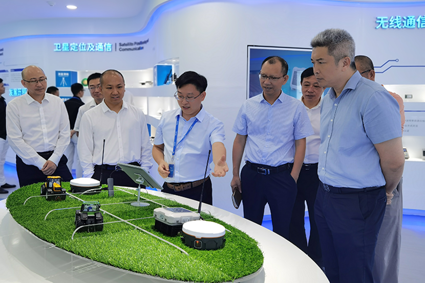
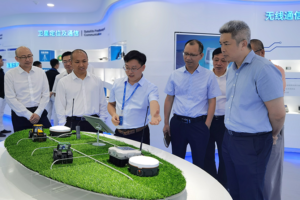
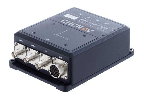
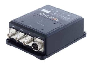
CHC Navigation has released the new CGI-610 GNSS/INS sensor, a high-precision dual-antenna receiver offering reliable and accurate navigation and positioning solutions for demanding land, marine and aerial applications.
The tight fusion of the latest GNSS technology with an industrial-grade MEMS IMU is powered by CHCNAV’s algorithms to deliver accurate hybrid position, attitude and velocity data, even in complex and obstructed environments where GNSS outages can occur.
The CGI-610 is a powerful GNSS/INS system supporting data output up to 100 Hz to meet the requirements of highly dynamic applications (including airplane, train and automobile). The optional external odometer sensor for ground vehicles can provide an additional independent measurement of displacement and speed, which is fused with the GNSS/INS navigation solution.
“The CGI-610 GNSS/INS sensor is the perfect answer to the growing demand of robust positioning and navigation systems for the control of any unmanned vehicle and machine, as well as for highly dynamic applications,” said George Zhao, CEO of CHC Navigation. “Industrial system integrators in need of a reliable GNSS/INS sensor with an exceptional price/performance ratio would definitely consider our CGI-610.”
With its 4G modem, CAN and serial ports, the CGI-610 GNSS/INS sensor offers unparalleled compatibility to enable a wide range of applications including machine control, port automation, advanced trajectography, robotics and unmanned vehicles. The CGI-610’s industrial design ensures reliable and consistent operation in the harshest environments.
Helps enable state and municipal government agencies to improve fleet operations and increases operational efficiencies
Photo: THEPALMER/E+/Getty Images
Geotab, an Internet of Things (IoT) and connected transportation company, has launched its Geotab Public Works solution in North America.
The all-in-one solution offers fleet managers full visibility into the operational data of all government vehicle types on a single platform,and provides the toolsets to effectively remain compliant, reduce costs and maintain road safety.
Designed to help government agencies better manage vehicles such as salt spreaders, snowplows, street sweepers and waste management vehicles, the Geotab Public Works solution is integrated with an extensive number of spreader controllers.
The solution is built to support key government business drivers including material management, compliance, accountability and liability. Providing public works departments with improved fleet management capabilities, fleets can utilize the solution to more accurately measure material usage, such as salt, allowing government fleet managers to feel more confident that community roads are not over- or underserviced.
With Geotab Public Works, government fleets are better able to control costs while reducing the impact that excessive material usage can have on the environment.
“Empowered by an industry-leading number of spreader controller integrations alongside various geospatial capabilities, the Geotab Public Works solution is designed to help government fleets optimize both their seasonal and ongoing fleet operations,” said Chris Jackson, associate VP of Business Development, Public Works and Smart Cities. “Spreader controllers provide fleet managers with rich insights that can help government agencies ensure that their fleets are adequately servicing roads without sacrificing the health of the environment.”
Available as a configurable add-in on the MyGeotab platform, the Geotab Public Works solution allows governments, including municipalities of all sizes, to customize their database to help meet the specific needs of their fleet.
In addition, users can add further value and customization through access to the Geotab Marketplace, an extensive portfolio of mobile apps, software add-ins and hardware add-ons that enable Geotab customers to further customize the fleet management solution.
“As many governments continue to look for ways to optimize their operations, Geotab Public Works is the type of robust, scalable, secure solution that provides real value by giving government fleet managers and local constituents unprecedented visibility to their public services,” said Jean Pilon-Bignell, vice president of Business Development, Government and Smart Cities at Geotab. “With high-frequency, near real-time reporting, the Geotab Public Works solution allows governments to know where their fleets are and how they are operating at all times, enabling fleet managers to more efficiently leverage their fleet data to provide better and more transparent services to their residents.”
“Recognizing the importance of driving engagement on future research, development and deployment of automated vehicles, we are confirming that all of the important content already planned for this year’s program will take place within a fully interactive virtual event platform,” organizers said.
The event will feature live sessions and networking, as well as a customizable schedule. In addition, keynote and plenary sessions will explore how society, technology and policy are preparing for and shaping the future of mobility.
GNSS Underground Coverage for Tunnels, Stations, Car Parks, Bus Stations and Airports in the U.K.
Syntony GNSS and Chronos Technology have formed a partnership to deliver underground GNSS positioning, navigation and timing (PNT) solutions for critical infrastructure applications in the United Kingdom.
Syntony GNSS is a leader and expert in the design and manufacture of GNSS systems, and Chronos Technology is a resilient GNSS system integrator.
GNSS coverage has become fundamental to many services from emergency services to asset tracking for example. Yet when entering an underground area such as a metro/subway, tunnel, car park, airport, or bus station for example, the GNSS signal is lost.
Syntony’s SubWAVE solution expands the GNSS coverage to underground areas, enabling the localization of any equipment with a standard GNSS chipset. Examples include standard smartphones and the TETRA Emergency Services Network handset used for security and services. Security and services applications include locating emergency calls, keeping track of staff, locating faults in tunnels, managing assets, locating trains and providing guidance.
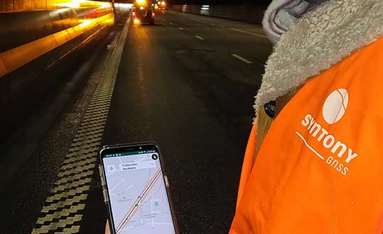
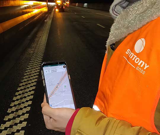
A Syntony team member in a Swedish road tunnel during SubWAVE testing shows the positioning in an underground environment on a smartphone. (Photo: Syntony GNSS)
By emitting a perfect emulation of the “real” GNSS signal, SubWAVE offers underground operators, their staff, emergency services and the general public the benefit of full GNSS coverage in all underground areas for both operational and safety reasons.
One fundamental aspect is the user only needs a standard GNSS receiver (a smartphone or TETRA radio) — no new handsets, receivers or apps are required. The system operates by broadcasting synthetic location specific GNSS signals through existing or new leaky feeder cables in the tunnels.
Accuracy levels vary with leaky feeder and system complexity options; however, 2-meter accuracy is possible with a standard smartphone. The system is widely installed in the Stockholm metro and is in active trials throughout Europe and America.
“We are pleased to form a partnership with GNSS specialists Chronos,” said Joel Korsakissok, president of Syntony GNSS. “Their knowledge and experience, together with their dedicated installation, commissioning and support teams complement our sophisticated solutions.”
“Since its first general availability, one of the well-known shortcomings of the GPS system was lack of indoor or underground coverage,” said Charles Curry, managing director with Chronos. “Many have tried to solve this with various technologies over the years. Syntony’s innovative technology offers underground GNSS coverage for PNT applications. We are very excited by the possibilities and pleased to be partnering with them to offer their solution for critical infrastructure applications in the UK.”
In addition, Chronos will also supply Syntony’s sophisticated GNSS simulators used in the aerospace and defence industries for product testing.