TDK’s booth at the Consumer Electronics Show (CES) is in South Hall 3, Booth #30306, and offers a look at sensors, passive components and more from TDK and its group companies. (Photo: TDK)
TDK Corporation has launched its InvenSense Coursa Drive software, an inertial-aided positioning solution for autonomous vehicle platform developers.
A high-performance extension of the InvenSense Positioning Library (IPL) that has provided sensor-aided positioning to more than 50 million devices worldwide, Coursa Drive enhances inertial-only vehicle positioning to <0.2 percent of distance traveled. These precise levels of accuracy are critical to maintaining decimeter lane-level vehicle positioning in challenging GNSS/perception system environments.
Coursa Drive’s inertial navigation system (INS) calibrates using absolute position inputs from either high-accuracy GNSS receivers or from perception-based systems (camera, radar, lidar) with high-definition (HD) maps.
In real time, Coursa Drive provides high-rate, 100 Hz delta positions and orientation to the autonomous vehicle (AV) system, complementing the lower-rate position references from GNSS and perception systems.
For improved system fault-tolerance, Coursa Drive can provide decimeter position precision for short periods when the GNSS or perception systems are uncertain or unavailable.
For non-real-time applications such as HD map creation and maintenance, Coursa Drive’s offline mode reprocesses INS data at two to three times higher accuracy than real-time mode, providing HD map companies alternative position references to verify HD map accuracy, even without GNSS, for up to 60 seconds.
“Coursa Drive delivers vehicle dead reckoning accuracy equivalent to high-end systems costing thousands of dollars,” said Mike Housholder, senior director of the TDK InvenSense Location Software and Services Business. “Our cost-effective software solution will help AV platform and Tier 1 vehicle manufacturers scale beyond prototype vehicles to high-volume mass production.”
Coursa Drive provides autonomous vehicle platform developers with maximum flexibility for system integration. The solution is platform agnostic and can operate on Cortex-M4F-class microcontrollers, or higher, and supports most dual-frequency GNSS receivers. The Coursa Drive API specifications are available upon request.
Coursa Drive is thoroughly tested and characterized using the InvenSense line of automotive-grade IMUs, including the IAM-20680 and IAM-20680HP, as well as several industrial grade IMUs. Coursa Drive is available now for select early partners and customers.
TDK and its group companies offering a comprehensive portfolio of sensors, electronic components and solutions for mobile, wearables, AR/VR, automotive, IoT and industrial applications will be at CES 2019, showcasing the Coursa Drive solution, along with additional innovative sensor solutions, in Booth #30306, Las Vegas Convention Center, South Hall 3, Jan. 8-11, Las Vegas.
Main applications
Level 2 to Level 5 advanced driver-assistance systems (ADAS)
Robotaxis
Trucking
Precision agriculture
Key features
World’s first high-precision inertial-aided positioning software for AVs
Inertial-only decimeter precise positions provided during short GNSS or perception system outages/uncertainties
High-rate, 100 Hz position and orientation updates supplied to the AV system
GNSS-agnostic software solution offers flexible integration for full-stack AV solution providers
Unique offline mode further enhances accuracy by two to three times for HD map building and maintenance applications.
Due to the extended impasse between U.S. Congressional leaders and the White House that has created a partial U.S. government shutdown, the Institute of Navigation (ION) has decided to postpone the Cognizant Autonomous Systems for Safety Critical Applications (CASSCA) Conference, originally scheduled to take place Jan. 28-29 at the Hyatt Regency Reston in Reston, Virginia.
The government shutdown has impacted CASSCA speakers and attendees and brought uncertainty about the number of government officials working in autonomous systems who are currently furloughed, making this decision inevitable.
The CASSCA Conference has been rescheduled for Sept. 16-17 in Miami, in parallel with ION GNSS+.
“The ION is committed to this strong and dynamic technical program and is confident this venue will provide maximum exposure and networking opportunities for the highly esteemed invited speakers and conference attendees,” the institute said in a press release. A revised program is available.
The ION’s International Technical Meeting (ITM) and Precise Time and Time Interval (PTTI) Systems and Applications meeting will proceed as scheduled, Jan.28-31, at the Hyatt Regency Reston, Reston, Virginia. ITM/PTTI 2019 is heavily supported by academia, industry and the U.S. Department of Defense; ITM/PTTI pre-registration levels are currently trending ahead of 2018 and the technical program is strong.
Hagai Zyss, CEO of Autotalks. (Photo: Daniel Danilov)
Autotalks’ second-generation chipsets have been selected by Harman International to provide the vehicle-to-everything (V2X) chipset for the Harman telematics platform. The platform will be showcased at the Consumer Electronics Show, taking place Jan. 8-11 in Las Vegas.
With V2X, all vehicles share location, speed and trajectory, giving drivers warnings of on-road dangers. Autotalks’ second-generation chipsets are mass-market ready and support both DSRC and C-V2X direct communications (PC5 protocol).
Harman is a wholly-owned subsidiary of Samsung Electronics Co. Ltd., focused on connected technologies for automotive, consumer and enterprise markets.
Harman will showcase a connectivity display of its telematics platform with C-V2X capabilities. The live demonstration will show a vehicle communicating with a motorcycle using C-V2X direct communications (the Autotalks chipset is used in both).
Harman’s solution consists of a modular telematics control unit (TEC) accommodating a cellular network access device (NAD) beside Autotalks’ second-generation chipset providing C-V2X capabilities. Autotalks C-V2X capabilities consist of a 3GPP compliant PC5 modem, with dual antenna and diversity for both transmission and reception, as well as an optimized closed-loop remote antenna solution for the highest radio performance.
“Autotalks is proud to work with Harman on their TCU with our secure and deployment-ready C-V2X solution,” said Hagai Zyss, CEO of Autotalks. “We are excited to have our chipset inside Harman’s telematics platform and to demonstrate the flexibility and maturity of our global V2X solution which has been chosen for series production by leading automakers.”
“Together with Harman, we will achieve deployment readiness before the mass-commercialization of C-V2X in China and elsewhere,” Zyss said.
“We are pleased to showcase Autotalks’ C-V2X capabilities in our Telematics platform at CES 2019,” said Mike Peters, president, Connected Car Division at Harman. “The Autotalks chipset provides us with the flexibility, security and performance needed in today’s worldwide market for telematics and V2X.”
Autotalks’ V2X chipset is now available for customer and partner demonstrations.
Septentrio, a high-precision GNSS company, and Sapcorda, a specialist in GNSS correction services, will conduct a live demonstration of a safe, high-accuracy positioning and correction solution for automated driving.
“We are running the demonstration during the course of this week just south of Las Vegas city center,” Neil Vacans told GPS World. Vacans is Septentrio’s vice president of global Sales. The demonstration is taking place in Las Vegas during the Consumer Electronics Show, being held Jan. 8-11.
Sapcorda and Septentrio have put together a solution that is ready for demonstration in Europe and North America.
The companies have combined their respective technologies to deliver the benefits of SSR (space state representation) technology seamlessly to OEM automakers and Tier 1 integrators. These benefits include decimeter-accuracy within seconds, anywhere over an entire continent, to support autonomy levels from lane keeping to full autonomy in a totally homogeneous coverage, the companies said.
The GNSS augmentation service is scalable through simple broadcast corrections, and safety-awareness is provided via Sapcorda’s integrity concept and Septentrio’s integrity monitoring engine.
In December 2018, Septentrio announced its mosaic compact multi-constellation GNSS receiver SiP (system-in-package) module, available in 2019. The Septentrio mosaic, a multi-band, multi-constellation receiver in a low-power surface-mount module with a wide array of interfaces, is designed for mass-market applications like robotics and autonomous systems. The mosaic module integrates the latest GNSS and RF ASIC technology, as well as the robust positioning engine from Septentrio.
All Septentrio GNSS receivers and modules feature AIM+ technology, an advanced on-board interference mitigation commercially available. Septentrio GNSS receivers can suppress the widest variety of interferers, from simple continuous narrowband signals to the most complex wideband and pulsed jammers.
“We are excited to be able to provide live demonstrations of Sapcorda’s safe and precise correction service especially designed for autonomous driving,” said Jan Van Hees, business development director at Septentrio. “Sapcorda provides a unique high-precision GNSS correction service designed for fast, homogeneous accuracy at continental coverage, thus ideal for autonomous and mass market applications.”
“Septentrio specializes in high-precision and high reliability GNSS positioning for a variety of industrial and commercial markets,” said Goran Jedrejčić, business development manager at Sapcorda. “They have developed a range of technologies, including unique jamming robustness and integrity positioning to support safety-sensitive applications in various challenging environments. Combining this with our safety-centered correction service, it is a unique solution for developers of autonomous driving systems.”
“With fast and efficient implementation of Sapcorda SSR-based correction service into Septentrio’s GNSS-platform, we were able to demonstrate the efficiency of the technology for automotive use in a robust & highly efficient way,” confirmed Jedrejčić. “Septentrio offers a unique blend of GNSS-based technologies and is an ideal partner for both traditional and new markets, with growing demand for high-precision positioning.”
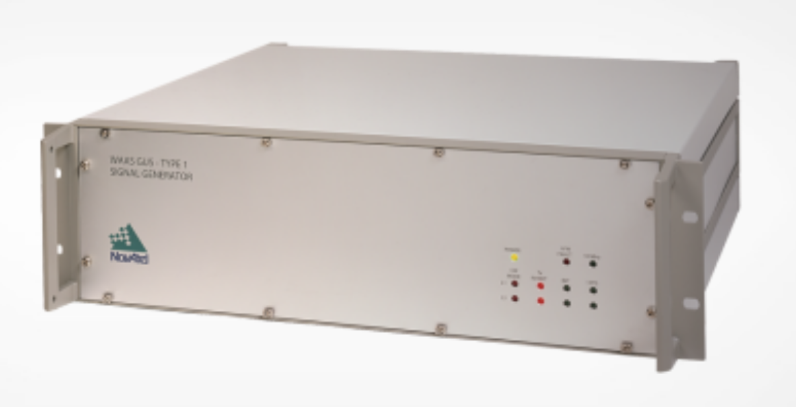
NovAtel has been awarded a contract from the United States Federal Aviation Administration (FAA) to design, produce and deliver 40 next-generation Ground Uplink Station (GUS) Signal Generators to support the FAA’s safety-of-life WAAS navigation service. The service provides safety-critical infrastructure for the North American aviation navigation network.
GUS signal generator. (Photo: NovAtel)
The contract also includes ongoing engineering support services for NovAtel’s complete portfolio of satellite-based augmentation system (SBAS) products deployed by the FAA, including the WAAS G-III reference receiver platform.
The FAA has relied on NovAtel’s safety-critical SBAS technology for more than 20 years, starting with NovAtel’s first-generation WAAS reference receiver that was created in the 1990s.
Developed by the FAA, the WAAS network is a safety-critical navigation aid that allows aircraft to use GPS for all phases of flight. Every time an aircraft takes off or lands within the WAAS coverage area, NovAtel technology is generating and processing data that allows aviators to make precision approaches to any airport.
Since the program’s inception, NovAtel has provided the FAA with technology that delivers high-precision GPS receiver measurements and navigation information from WAAS Reference Stations and the GUS infrastructure.
Under this new contract, NovAtel will help modernize the WAAS network by upgrading and extending support for the network’s GUS infrastructure. The next-generation of GUS signal generators, which are designed specifically for SBAS ground uplink systems, will include independent L1 and L5 signal paths to precisely control the frequency and phase of L1 and L5 code and carrier for dual-frequency SBAS.
A GUS receiver system based on the WAAS G-III receiver platform will also be released along with the signal generator to complete the modernized GUS control loop.
“We have a long history with the FAA and have worked very closely with the WAAS program team to develop multiple-generations of SBAS infrastructure,” said Jonathan Auld, vice president of engineering and safety critical systems at NovAtel. “NovAtel remains committed to supporting the FAA and their safety of life WAAS service and we are excited to deliver this critical next-generation technology for SBAS modernization.”
Space Based Augmentation Systems (SBAS) – known in North America as the Federal Aviation Administration’s (FAA’s) Wide Area Augmentation System (WAAS) – have been fully operational in one form or another for several years. The FAA’s incremental improvements to integrity, accuracy and reliability in WAAS have brought the system to a point where we have precision en-route navigation for aircraft, and we can also land aircraft using WAAS signals at thousands of airports in the US and in Canada.
Why not Mexico, which also benefits from the same WAAS coverage? More on that later, as we piece together the many parts of the complex SBAS mosaic.
SBAS precision approach coverage, May 2016. Graphic: FAA Tech Center, Lockheed Martin, GMV
Europe benefits from high-accuracy en-route navigation, and there are also hundreds of operational approaches using the European Geostationary Navigation Overlay Service (EGNOS) SBAS.
In India, the GPS Aided Geo-Augmented Navigation (GAGAN) system provides accurate en-route navigation and approach capability. However, ionospheric disturbance may limit some aspects of performance.
Japan established the Multi-functional Satellite Augmentation System (MSAS) SBAS, and has benefited from improved en-route navigation, but it’s possible that the more limited geographic distribution of GPS ground reference stations has restricted improvements to approach capabilities.
But what happened to the International Civil Aviation Organization (ICAO) concept from 2007, supported by all the ‘aviation-going’ countries of the world, that SBAS would evolve and eventually multiple national systems would provide coverage around the rest of the world, maybe even by 2016?
Countries in Asia, South America, Africa and the continent of Australia all appear to have looked closely into establishing their own SBAS, but nothing seems to have come out of these investigations. Technical issues, cost, and political obstacles have all hindered global SBAS progress.
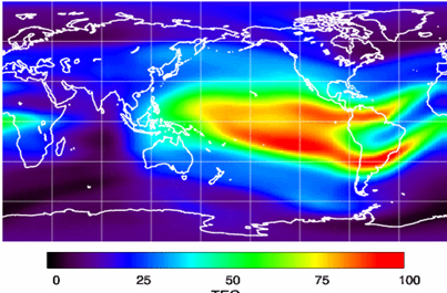
The ionospheric challenge. Graphic: GMV and Lockheed-Martin
Technical Issues. Ionospheric scintillation problems around the Equator seem to be at the root of most technical problems for SBAS. Getting to the required level of probable, bounded system error is hugely difficult. The iono disturbance ‘blob’ follows the sun around the Equator and wipes out any chance of satisfactory system performance when it passes over Equatorial countries.
As total electron count (TEC) increases, the ionospheric grid, which most SBAS use to predict ionospheric variation across their geographic area between fixed reference stations, well, it just doesn’t work anymore.
Cost. The capital cost of building a satellite-based augmentation system and the on-going cost of maintaining a bunch of geographically distributed reference sites, building and launching GEO satellites or renting transponders on someone else’s orbiting asset, establishing, operating and maintaining redundant uplink stations, redundant terrestrial data links, and setting up control systems that collect and create the SBAS uplink message — it all adds up. Millions and maybe even billions of dollars or equivalent, in total, have been spent by those select countries who could afford their own SBAS. Others named above have lesser financial resources upon which to draw.
Political Obstacles. One of the trickiest issues is sovereignty: the need for a country to control its own navigation and landing system. This has likely been the source of most resistance to more SBAS systems being set up and shared by bordering countries around the world.
For a large number of smaller countries, SBAS would only make sense if it was shared across a number of neighboring countries, but that means relinquishing sovereignty to some degree. In several regions of the world a number of geographically adjacent countries don’t particularly like each other, never mind thinking of such sharing/collaboration.
National sovereignty, by the way, isone of the main reasons that existing satellite navigation systems underpinning SBAS, such as Galileo, GLONASS, IRNSS (now NAVIC), QZSS and of course BeiDou have all been put in place.
Another problem with potential SBAS sharing across adjacent countries stems from responsibility for liability. Should something not work and an accident ensues from such a malfunction, who’s liable? Mexico seems to have adopted the view that since the US provides WAAS on what could be called an ‘as-is’ basis, then the potential liability issue seems to trump using the system.
Solutions? Technical issues with the ionosphere may soon be resolved by using dual-frequency L1/L5 airborne receivers that directly calculate their own ionospheric corrections, rather than using the computed SBAS iono grid. If we add in dual-frequency E1/E5a signals from Galileo, things start to get even better. New requirements and prototype equipment are already being developed for dual frequency multi-constellation airborne receivers. Airbus anticipates equipping aircraft with such receivers around 2025. Could this solve the SBAS technical issue for Equatorial countries?
ARINC (now a UTC/Rockwell Collins company) and SITA (in Europe) have been providing commercial aircraft with operational communications services on a pay-for-use basis for a number of years, and this is notarized as an accepted means of compliance within ICAO policy/requirements:
From ICAO Doc. 9161, Sec. 3.99: “A group of states or a regional organization might also undertake to operate the augmentation satellite service required, either by themselves or by contracting a commercial or government organization to do so on their behalf.”
ARINC en-route coverage. Graphic: ARINC
Aireon has partnered with NAV CANADA, the Irish Aviation Authority (IAA), Enav, NATS and Naviair, as well as Iridium Communications and Harris Corporation to provide real time ADS-B data (GPS position output from aircraft) to air-traffic control providers. Aireon’s payloads on the new Iridium NEXT Low-Earth Orbit (LEO) satellite constellation will receive aircraft ADS-B messages and relay them to Air Traffic Controllers in real-time.
There are 66 Iridium NEXT satellites in operation, with significant overlap and redundancy built into the system to enable this safety-of-life service to be provided on a pay-for-use basis to the aviation industry. We could at last know the location of every suitably equipped aircraft in the air, in almost real-time. The ICAO requirement is for an update rate of 15 minutes.
Inmarsat ADS-C is a similar service available to aircraft on a contracted, pay-for-use basis via Inmarsat GEO satellites.
Market Solutions. If a substantial company showed up with a worldwide distributed SBAS solution and offered it on a fee for service basis, why wouldn’t countries that are already accustomed to ARINC and SITA pay-for-use communications? The Aireon international aircraft tracking system, to be provided on the same basis, adds to the credibility of such a pay-for-use service.
So why wouldn’t these accepted services demonstrate to those countries concerned about control and national sovereignty that an SBAS service could be provided on this basis?
The liability for provision of service sits with the providers, so user countries/airlines would have someone to turn to about liability issues, and there presumably could be contract terms to provide system performance guarantees.
No huge capital costs, no system to construct, nor staff to operate or maintain, and yet a level of control similar to that which has been around for commercial aircraft communications for decades.
Would this be of interest to countries that have not yet jumped on the SBAS bandwagon? A definite ‘maybe,’ we could imagine? What’s not to like?
The punch line to all this is that Lockheed Martin and GMV (Spain) have teamed to challenge these non-SBAS countries with a solution which may appeal.
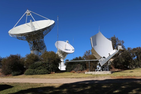
Uralla reference test site. Photo: Lockheed-Martin
To present convincing evidence that it would work, a dual frequency GPS (L1/L2) + Galileo (E1/E5a) reference site has been set up in collaboration with Geoscience Australia and Land Information New Zealand. The reference site is located at Uralla, New South Wales on Australia’s East Coast, where it gathers data demonstrating bounded errors within the operational range which could enable GNSS approach capability.
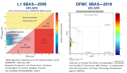
L1 (2006) vs. DFMC (2018) SBAS at Bangkok. Graphic: Lockheed-Martin, GMV
Another test site in Bangkok, Thailand has demonstrated that existing L1-only SBAS in this area cannot manage this performance (all current SBAS are L1 only), but that with dual-frequency multi-constellation (DFMC) GPS L1/L2+Galileo E1/E5a, the required performance limits could be met.
Lockheed Martin has also been using the Uralla uplink site to test the uplink and downlink of dual-frequency SBAS-like test messages.
The Moral of the Story. There are no miracles as yet, but interest in the pay-as-you-go SBAS concept appears to be growing, and the LM/GMV team continues to work to bring their approach to market.
A large number of countries could well benefit from the high accuracy, integrity and continuity of SBAS service if this all comes together.
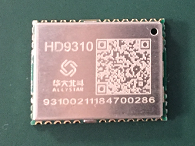
Allystar Technology Co. Ltd., headquartered in Shenzhen, China, has released a multi-band multi-GNSS chipset, the HD9310. The new product is based on the Cynosure III architecture integrating multi-band multi-system GNSS RF and baseband.
A multi-band, multi-system system-on-chip, it supports BeiDou-3 and is capable of tracking all global civil navigation systems (GPS, BeiDou, Galileo, GLONASS, IRNSS, QZSS and SBAS) in all bands (L1, L2, L5, L6), said Simon Sun, Allystar general manager.
Photo: Allystar Technology
Designed for high-precision applications, the HD9310 measures 5.0mm x 5.0mm. The architecture integrates floating-point arithmetic units based on ARM CortexM4, 160 KB RAM, 32KB backup RAM with VBAT, 386 KB embedded FLASH and peripheral interfaces UART, I2C, SPI, GPIO, CAN.
In terms of the manufacturing processes, it adopts a 40nm process and incorporates a variety of advanced design technologies, endowing it with very power consumption: less than 50mA.
The quad-flat no-leads package allows customers to reduce printed circuit board and bill of materials costs while reducing the number of peripheral devices. This chip supports CAN interface and can be widely used in vehicle management, car navigation, wearable devices, GIS data collection, precision agriculture, smart logistics, driverless, engineering survey and other fields.
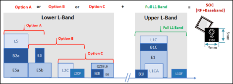
“The HD9310 supports three options of RF setting — A, B, C — for product developers to quickly bring their ideas to the different application and markets,” added Shi Xian Yang, high precision project manager at Allystar.
Three available options for the HD9310 chipset. Graphic: Allystar Technology
Option A, focused on L5 band, L5/E5, maximizes measurement accuracy and improves multipath mitigation based on higher chip rate.
Option B is focused on L2 band, and suitable for relative position applications, for example, real-time kinematic (RTK), because worldwide continuously operating reference stations (CORS) commonly support L1/L2/L1OF/L2OF.
Option C is focused on the L6 band and is designed for PPP applications, receiving state space representation (SSR)-type corrections to be broadcast from satellites in the coming future, and supporting B3I already.
The HD9310 comes with built-in support for standard RTCM Protocol (MSM), supporting multi-band multi-system high-precision raw data output, including pseudo range, phase range, Doppler, SNR for any kind of 3rd party integration and application.
Module. Allystar Technology also has launched a multi-band multi-GNSS module, TAU1302, which integrates the HD9310 chipset and measures 12 × 16 × 2.3 millimeters.
With the features of small size, low power consumption (<50 mA), and ease of integration and mass production, HD9310 is suitable for high-precision applications such as vehicle management, car navigation, wearable devices, GIS data collection, precision agriculture, smart logistics, driverless, engineering survey and other fields.
Customer samples of the HD9310 chipset are available now.
The M.A.D.S. radomes track drones at the port, so they can be identified as beneficial or a threat. (Photo: Martek)
The Port of Amsterdam has begun a four-week trial of a drone detection system. Martek Anti-Drone Systems is providing its M.A.D.S. (Marine Anti-Drone System) to build understanding of how, where and why drones are flying over the Port of Amsterdam.
The M.A.D.S system will support the port by monitoring legal and illegal flying across its land. The system detects and identifies drones within a 5-kilometer range, providing GPS positioning of both drone and pilot together with the drone’s speed and heading.
Configurable and escalating stage alarms in real time allow the drones’ intentions to be assessed in time to decide on appropriate defense actions.
M.A.D.S. radomes are installed around the Port of Amsterdam. (Photo: Martek)
The data collected from the trial will have far-reaching influence on the future use of UAVs (unmanned aerial vehicles) across the 650-hectare port area, according to Martek.
The port has identified the potential of drones for numerous use applications across its operations and its customers’ operations. Many port customers are preparing to use drones for infrastructure inspection and measurement of environmental parameters. The trial will monitor their use.
Project manager of innovation Joost Zuidema is overseeing the trial for the Port Authority. “This trial is an important part of our innovation strategy,” Zuidema said. “The M.A.D.S system gives us a first opportunity to get a feeling for the technology that will help us understand drone usage and make a first assessment on unwanted drone flights in a part of our port.”
Like any tool, drones are being used for good as well as malevolent purposes. There is a potential threat to transport such as container ships and major infrastructure, such as ports, around the world. Threats include:
privacy invasion
terrorism threats of explosives or gas attack
flyby hacking to take control of autonomous or semi-autonomous systems
stealing valuable data off unprotected networks or breaking into insecure networks
Infographic: Martek:
“As the Port Authority, we do want ensure drone flights in our port are carried out safely and responsibly, within the laws and regulations,” Zuidema said.
“The growing trend for the use of UAVs being used on ports, commercial shipping and super yachts is, as yet, not fully recognised by authorities,” said Erik Van Wilsum, Martek. “We are delighted to be working with Port of Amsterdam, who are on the cutting edge of developing technology to understand the opportunities for drone use and the potential threats and benefits they can provide for key national infrastructure.”
A report by International Data Corporation stated that it expected worldwide investment in drones to be US$12.3 billion in 2019, with drone purchase growing nearly twice as fast as the investment in robotics over the same period.
Rohde & Schwarz and Huawei have successfully conducted cellular-based 5G V2X latency measurements in vehicular environments in field tests in Munich and Shanghai.
In a joint project between Huawei and Rohde & Schwarz, a precision end-to-end delay measurement system for over-the-air IP transmissions was applied to 5G V2X communication for cooperative driving applications in field tests in a moving car.
The precision absolute time standards on both ends were derived from two independent GPS receivers.
URLLC will enable automated driving. (Image: Rohde & Schwarz)
The initial measurements show that it is possible to achieve delays in the millisecond regime in a 5G network, demonstrating superior latency performance in comparison to LTE.
One of the key use cases of 5G is ultra-reliable low-latency communication (URLLC). Important for advanced vehicle-to-X communication use cases, URLLC will enable automated driving in the future.
A measurement accuracy below 2 µs for each transmitted IP packet was demonstrated. The transmitted data contained various IP traffic streams including video, lidar and control data (ITS messages) for a tele-operated vehicle.
While the trial in Munich was related to a tele-operated driving project, the tests in Shanghai were related to a platoon V2X testing site, where a number of vehicles traveling together are electronically connected via wireless communication.
The delay for transmission of one IP packet from source over-the-air to a (moving) receiver (sink) needs to be measured, spanning all delays introduced by the radio transmitter, propagation delay and radio receiver from/to IP packet level.
As latency is one of the key performance indicators of 5G and crucial for safety applications, such measurements could become an important criterion for future certification testing.
“We are delighted to collaborate with Huawei to contribute with our test and measurement expertise to 5G technology development,” said Andreas Pauly, executive vice president, Test & Measurement at Rohde & Schwarz. “With a strong global footprint in the telco ecosystem and close cooperation with partners, Rohde & Schwarz is committed to further expanding our innovative test and measurement solutions to new automotive applications.”
Audi, Airbus and Italdesign presented for the first time a flying and driving prototype of Pop.Up Next, a flying taxi. The companies demonstrated the concept at Drone Week, held Nov. 27-29 in Amsterdam.
The concept combines a self-driving electric car with a passenger drone. In the first public test flight, the flight module accurately placed a passenger capsule on the ground module, which then drove from the test grounds autonomously.
Photo: Audi
The demonstration was done with a 1:4 scale model. But as soon as the coming decade, Audi customers could use the flying taxi service in large cities — in multi-modal operation, in the air and on the road, without changing vehicles.
“Flying taxis are on the way. We at Audi are convinced of that,” said Bernd Martens, Audi board member for sourcing and IT and president of the Audi subsidiary Italdesign. “More and more people are moving to cities. And more and more people will be mobile thanks to automation. In future senior citizens, children, and people without a driver’s license will want to use convenient robot taxis. If we succeed in making a smart allocation of traffic between roads and airspace, people and cities can benefit in equal measure.”
To see what an on-demand service of this kind could be like, Audi is conducting tests in South America in cooperation with the Airbus subsidiary Voom. Customers book helicopter flights in Mexico City or Sao Paulo, while an Audi is at the ready for the journey to or from the landing site.
“Services like this help us to understand our customers’ needs better,” Martens said. “Because in the future, flying taxis will appeal to a wide range of city dwellers. With Pop.Up Next we are simultaneously exploring the boundaries of what is technically possible. The next step is for a full-size prototype to fly and drive.”
Audi is also supporting the Urban Air Mobility flying taxi project in Ingolstadt. This initiative is preparing test operations for a flying taxi at Audi’s site, and is part of a joint project of the European Union in the framework of the marketplace for the European Innovation Partnership on Smart Cities and Communities.
The project aims to convince the public of the benefits of the new technology and answer questions concerning battery technology, regulation, certification and infrastructure.
Rolls-Royce and Finnish state-owned ferry operator Finferries have successfully demonstrated a fully autonomous ferry in the archipelago south of the city of Turku, Finland.
The car ferry Falco used a combination of Rolls-Royce Ship Intelligence technologies to successfully navigate autonomously during its voyage between Parainen and Nauvo. The return journey was conducted under remote control.
During the demonstration, the Falco, with 80 invited VIP guests aboard, conducted the voyage under fully autonomous control. The vessel detected objects utilizing sensor fusion and artificial intelligence and conducted collision avoidance. It also demonstrated automatic berthing with a recently developed autonomous navigation system. All this was achieved without any human intervention from the crew.
The Falco is equipped with a range of advanced sensors which allows it to build a detailed picture of its surroundings in real time. The situational awareness picture is created by fusing sensor data and it is relayed to Finferries’ remote operating centre on land, some 50 kilometres away in Turku city centre. Here, a captain monitors the autonomous operations, and can take control of the vessel if necessary.
During the autonomous operation tests in Turku archipelago, Rolls-Royce has so far clocked close to 400 hours of sea trials. The Rolls-Royce Autodocking system is among the technologies that have been successfully tested. This feature enables the vessel to automatically alter course and speed when approaching the quay and carry out automatic docking without human intervention. During the sea trials, the collision avoidance solution has also been tested in various conditions for several hours of operation.
Earlier this year Rolls-Royce and Finferries began collaborating on a new research project called SVAN (Safer Vessel with Autonomous Navigation), to continue implementing the findings from the earlier Advanced Autonomous Waterborne Applications (AAWA) research project, funded by Business Finland.
“Today marks a huge step forward in the journey towards autonomous shipping and reaffirms exactly what we have been saying for several years, that autonomous shipping will happen,” said Mikael Makinen, president – Commercial Marine at Rolls-Royce. “The SVAN project has been a successful collaboration between Rolls-Royce and Finferries and an ideal opportunity to showcase to the world how Ship Intelligence technology can bring great benefits in the safe and efficient operation of ships.
“This is a very proud moment for all of us and marks our most significant milestone so far. Today’s demonstration proves that the autonomous ship is not just a concept, but something that will transform shipping as we know it.”
“We are very proud that maritime history has been made on the Parainen-Nauvo-route once again,” added Mats Rosin, Finferries’ CEO. “First with our world-renowned hybrid vessel Elektra and now Falco as the world’s first autonomous ferry. As a modern ship-owner, our main goal in this cooperation has been on increasing safety in marine traffic as this is beneficial for both the environment and our passengers. But we are also equally excited about how this demonstration opens the door to the new possibilities of autonomous shipping and safety.”
The Falco is a 53.8 metre double-ended car ferry, which entered service with Finferries in 1993. It is equipped with twin azimuth thrusters from Rolls-Royce.
“As of today [Nov. 28] Tesla owners have driven 1 billion miles with Autopilot engaged,” the company announced via tweet.
The Autopilot feature became available in 2015 and now comes on all new Tesla models with a $5,000 activation fee at the time of purchase or $7,000 if selected later.
The company is training its “neural networks” to improve its self-driving system.
Photo: Tesla
Tesla’s global fleet totals more than half a million vehicles, and recently marked a 20-billion mile step of total electric miles driven, the company said.
The Autopilot system can also function in the background of the vehicle, without being activated and with no input on control. Thus it gathers data from many more billions of “drivered” miles about its environment and potential Autopilot behavior.
The company previously mentioned the 1 billion-mile autonomous mark as the minimum it would need to move Autosteer from beta to a regular feature.
Updates to Autopilot are planned for 2019, including new hardware that will aid in the rollout of the company’s Full Self-Driving system, possibly by the end of that year.