A link to the live event will be sent to you two hours before the event. Your personalized event URL will be automatically generated by the ON24 system. To ensure receipt of the email, please whitelist this email address by adding it to your contacts: [email protected].
This presentation will begin on Thursday, May 19, 2016, at 1 p.m. EDT.
Audience members may arrive 15 minutes prior to live time. You may need to download Flash Player in advance. If you have any questions, please contact event producer Allison Barwacz at [email protected].
On Monday, April 18, an unmanned aerial vehicle (UAV) was reported to have struck a British Airways Airbus as it descended into London’s Heathrow Airport, reports BBC News.
The collision has renewed calls from the Air Line Pilots Association for stricter regulation in the U.S., where more than 150 airliners reported close sightings of drones in the last 18 months, including eight in the last two weeks of January. A drone collision could disable an aircraft if the metal frame and battery of a drone come in contact with an airliner’s engine.
Authorities in Britain are investigating the incident, and trying to determine who might have been behind it.
British Airways Flight BA727 from Geneva was approaching Heathrow on Sunday afternoon when what the pilot believed to be a drone struck the front of the aircraft, London Metropolitan Police said. The plane was 1,700 feet in the air at the time.
The Airbus A320 landed safely, with none of the 132 passengers and five crew members on board injured, British Airways spokesman Michael Johnson said. The plane was fine, and continued with service.
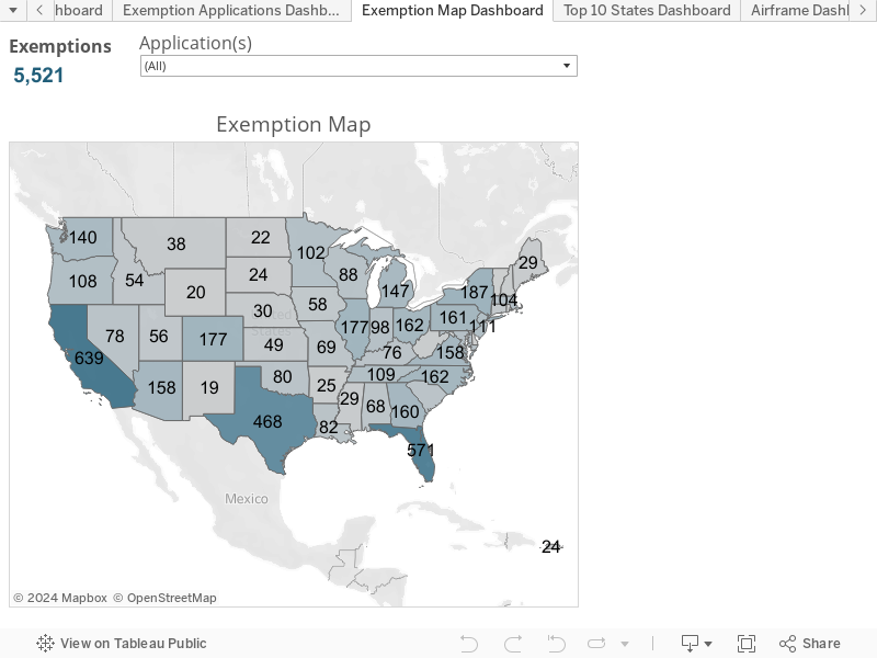
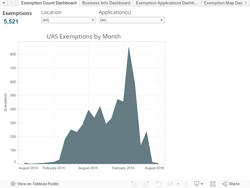
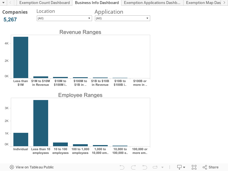
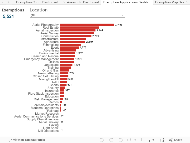
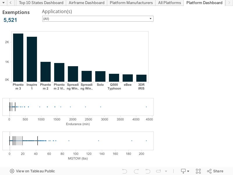
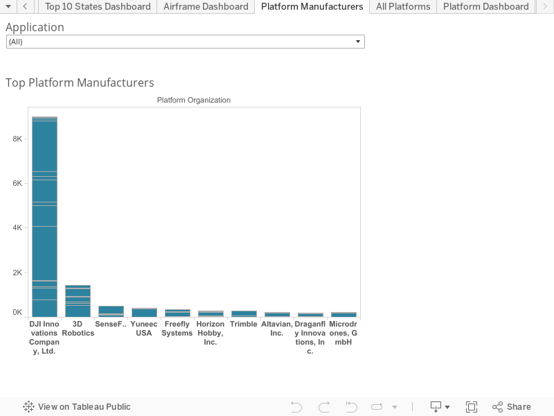
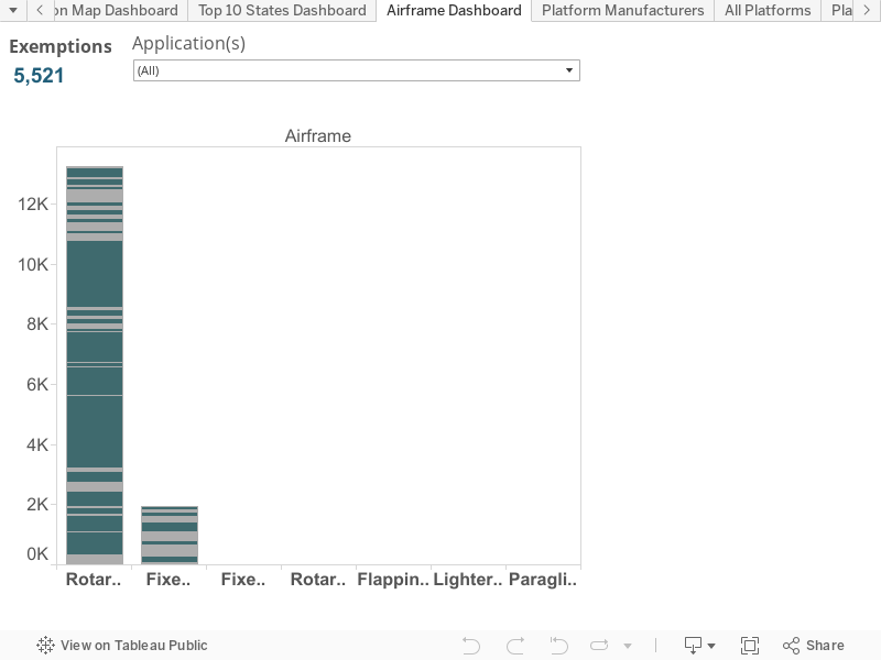
The Association for Unmanned Aerial Vehicles (AUVSI) unveiled an interactive analysis of U.S. Federal Aviation Administration (FAA) Section 333 unmanned aircraft system (UAS) exemptions.
The FAA has awarded more than 3,000 Section 333 Exemption Grants since September 2014 to allow individuals, businesses, non-profits and governmental agencies to fly drones.
AUVSI’s Unmanned Systems and Robotics Database provided the data for the analyses, which shows UAS exemptions by state and month, a business analysis revealing revenue and employees, UAV applications, top manufacturers, top drones, airframe and industry.
The report finds that finds 38 types of business operations have been approved by the FAA to fly UAS commercially in the National Airspace System (NAS). Aerial photography received the most, followed by real estate and aerial inspection.
The report also finds that exemptions have been approved in all 50 states, as well as Puerto Rico.
“The UAS industry is poised to be one of the fastest growing sectors in the U.S., and these numbers demonstrate that a wide variety of industries are eager to take advantage of this technology,” said Brian Wynne, president and CEO of AUVSI. “From inspecting our nation’s infrastructure to providing farmers with aerial views of their crops, the applications of UAS are virtually limitless. It’s no wonder businesses – small and large – are clamoring to use this technology.”
Congress also mandated that the FAA develop rules for integration of UAS into the national airspace, however these rules, which would provide anyone who follows the rules access to the airspace, are not expected until at least June 2016.
The AirMap Digital Notice and Awareness Dashboard(TM) airport manager view.
AirMap and the American Association of Airport Executives (AAAE) have released the Digital Notice and Awareness System (D-NAS), created to allow UAS operators to provide airports with real-time digital information about the location of their flights.
AirMap is a provider of airspace information and services for unmanned aircraft. On April 7, the company announced that it raised a $15 million Series A financing led by General Catalyst Partners to accelerate its global development airspace management tools for drones.
D-NAS works by allowing a UAS operator to send an encrypted digital flight notice to a secure dashboard at an airport’s operations center. Flight information can be submitted through various UAS interfaces, including the flying apps provided by drone manufacturers DJI, Yuneec and 3DRobotics.
These connections facilitate the transmission of important safety-critical information to airports, including the GPS location of the UAS flight. Participating airports will access this information through the AirMap D-NAS dashboard, which provides a map view of flights in proximity to the airport and the option to contact the UAS operator directly.
“Safety has always been a priority for DJI,” said Brendan Schulman, DJI’s vice president of Policy and Legal Affairs. “Providing our customers the capability to easily notify nearby airports of their flights is a huge step forward in convenience and functionality. A high-tech notification system complements the safety features DJI builds into every drone, as well as DJI’s close work with policymakers on practical approaches for drone technology.”
More than 50 airports across America have already joined the D-NAS pilot program, including Houston’s George Bush Intercontinental and William P. Hobby airports, Denver International Airport, Columbus Air Force Base in Mississippi, Charlotte-Douglas Airport in North Carolina, Reno-Tahoe Airport in Nevada, New Castle Airport in Delaware, Cape May Airport in New Jersey, Fairbanks International Airport in Alaska, and the Oxnard and Camarillo Airports in Ventura County, California.
The AirMap Digital Notice and Awareness Dashboard map view.
“Participation in the D-NAS pilot was a no-brainer for us. In the face of growing concerns over UAS operations near airports, AirMap has developed an effective and unique solution,” said Steve Runge, Division Manager for the Houston Airport System. “D-NAS is a game changer for how we will manage low altitude air safety.”
D-NAS not only provides heightened awareness to airports; it also makes it easier for UAS operators to comply with Section 336 of the FAA Modernization and Reform Act of 2012, which requires notice to be given to airports within five miles of a drone’s flight location.
Ben Marcus, CEO of AirMap and an airline transport rated pilot and flight instructor, said, “Everyone involved in aviation sees the promise and potential of unmanned aircraft. However, we can’t reach the potential of this amazing technology unless we ensure that safety critical information keeps pace with innovation. We are focused on building the tools for unmanned aircraft to safely integrate into the national airspace system.”
“We are excited to work with AirMap to improve the safety features of our products,” said Yuneec CEO Tian Yu. “As an airplane and helicopter pilot myself, I know first-hand how important it is to keep the national airspace system safe.” Yuneec is the manufacturer of the Typhoon and Tornado series of multirotor drones and recently announced a $60M investment from Intel.
The Federal Aviation Administration (FAA) is now reviewing the report and recommendations of the Micro Unmanned Aircraft Systems (UAS) Aviation Rulemaking Committee. The agency had tasked the group to develop recommendations for performance-based regulations that would let certain unmanned aircraft operate over people not directly involved in the flight of the aircraft.
The rulemaking committee, which began meeting March 8, worked under a tight deadline of April 1 to deliver its report. The task force included a diverse set of aviation stakeholders, including UAS manufacturers, UAS operators, consensus standards organizations, researchers and academics.
“We commend the committee members for their sincere dedication and for producing a comprehensive report in such a short time,” said FAA Administrator Michael Huerta. “This type of collaborative government and industry partnership is exactly what is needed to keep pace with this rapidly changing industry and will serve as a model for future rulemaking advisory tasks.”
The ARC’s consensus report recommends establishing four small UAS categories, defined primarily by risk of injury to people below the flight path. For each category, the group recommends assigning a potential risk linked to either weight or impact energy. The report also addresses operational restrictions and standards to minimize the risks associated with each category.
The FAA will use the information in the report to develop a flexible, performance-based proposed rule. The public will have an opportunity to comment on the proposal based on the ARC’s recommendations.
Illustration of the contemplative real-time (CRT) window measurement timeline. The window contains a prior for the initial state, K GPS measurements, and many IMU measurements between each pair of GPS measurements. IMU measurement times are indicated as dots on the timeline. All of these items yield constraints on the estimated trajectory ˆX during the CRT window.
Integer ambiguity resolution in multi-epoch GPS/INS
A novel integer ambiguity resolution approach over a time window of GPS/IMU data enhances the reliability of obtaining high-accuracy position estimation, using carrier phase measurements, even in challenging environments. The method focuses on reducing computational cost. The achievable savings should be on the order of 104, while 600 has been demonstrated. The theoretical approach shows that the cost function can be decomposed into one part that determines the shape and vicinity of the trajectory, but is insensitive to the carrier phase integers and a position shift vector, and a second part that is sensitive to the carrier phase integer and can be solved to determine the required position shift so that the location of the trajectory is accurately known.
By Yiming Chen, Sheng Zhao, and Jay A. Farrell, University of California, Riverside.
Indoor Flight Demonstration Results of an Autonomous Multi-copter Using Multiple Laser Inertial Navigation, by Adam Schultz, Russell Gilabert, and Maarten Uijt de Haag, Ohio University.
This paper discusses aspects of autonomy on a small-size multi-copter UAS for challenging environments, addresses in detail the modified proposed navigation algorithm, its integration with the flight controller for autonomous flight and the actual implementation on the multi-copter platform. The paper includes flight test results of a multi-copter UAS operating in an outdoor/indoor environment and shows some navigation and mapping performance results.
A new market report, “Unmanned Aerial Vehicle (UAV) Payloads & Subsystems Market Report 2016-2026,” is being offered by Visiongain. According to the 302-page report, the global UAV payloads and subsystems market is set to grow as nations seek to sustain and enhance their capabilities as the probability for symmetric warfare increases.
Communications and navigation UAV payloads and subsystems is one of four submarkets analyzed in the report, along with EO/IR, radar and intelligence.
The report answers questions such as:
What are the future prospects for the overall UAV payloads and subsystems market?
Who are the key players within the UAV payloads and subsystems market?
What are the drivers and restraints underpinning the UAV payloads and subsystems market?
Where are the most promising business opportunities by region, by technology and end use application?
Global drone manufacturers 3DR, DJI, GoPro and Parrot today are forming the Drone Manufacturers Alliance, a coalition intended to serve as the voice for drone manufacturers and their customers across civilian, governmental, recreational, commercial, nonprofit and public safety applications.
“We will advocate for policies that promote innovation and safety, and create a practical and responsible regulatory framework,” said Kara Calvert, director of the Drone Manufacturers Alliance. “There are significant economic and social benefits to drone operations in the U.S., and industry must work with policymakers to ensure a safe environment for flying.
“The Drone Manufacturers Alliance believes a carefully balanced regulatory framework requires input from all stakeholders and must recognize the value and necessity of continued technological innovation. By highlighting innovation and emphasizing education, we intend to work with policymakers to ensure drones continue to be safely integrated into the national airspace.”
Starting March 31, owners of small unmanned aircraft systems (UAS) used for commercial, public and other non-model aircraft operations will be able to use the FAA’s new, streamlined, web-based registration process to register their aircraft.
The web-based process will significantly speed up registration for a variety of commercial, public use and other users. Registration for those users is $5, the same fee that model aircraft owners pay.
“Registration is an important tool to help us educate aircraft owners and safely integrate this exciting new technology into the same airspace as other aircraft operations,” said FAA Administrator Michael Huerta.
All owners of small UAS used for purposes other than as model aircraft must currently obtain a 333 exemption, a public certificate of authorization or other FAA authorization to legally operate, in addition to registering their aircraft. Before today, the FAA required all non-hobby unmanned aircraft owners to register their aircraft with the FAA’s legacy aircraft registry in Oklahoma City, Oklahoma.
Those owners who already have registered in the legacy system do not have to re-register in the new system. However, the FAA is encouraging new owners who are registering for the first time to use the new, web-based registration system.
Owners who register under the new system can easily access the records for all of the aircraft they have registered by logging into their on-line account.
Small UAS owners who have registered under the web-based system who intend to use their aircraft for purposes other than as model aircraft will also need to re-register to provide aircraft specific information.
The FAA first opened up the web-based registration for model unmanned aircraft owners on Dec. 21, 2015.
The agency is expanding that existing website to accommodate owners of aircraft used for purposes other than model aircraft. This registration process includes additional information on the manufacturer, model and serial number, in addition to the owner’s physical and email addresses. Like the model aircraft registration process, a certificate is good for three years, but each certificate covers only one aircraft.
Image objects/themes (“horizon”, “nature”) and landmarks (“savannah”) found by Google Cloud Vision service automatically added as tags.
The Nuxeo Platform is integrating with the Google Cloud Vision API, a new service providing information and insights automatically detected within images. The plugin is now available to download directly from the Nuxeo Marketplace, which offers optional packages to easily add new features to the Nuxeo Platform.
The Nuxeo Platform enables organizations to manage complex digital content at massive scale.
Using the plugin, the Nuxeo Platform exposes a powerful set of configurable image analysis features that can be applied upon file import, within a given workflow/business process, and/or on demand after a specific user action.
Nuxeo also applies Google Cloud Vision to videos using images (video frames) captured by the Nuxeo storyboard, identifying landmarks (“Eiffel Tower”) and objects/themes (“human action”, “mobile device”) saved as tags.
In addition to processing any image attached to content objects, the Nuxeo Platform also applies the capabilities to video, using images extracted from the video storyboard.
Image features detected by the Google Cloud Vision service are available for use with Nuxeo process automation and business logic, and can also be stored as metadata and tags on the content object, including:
Image labeling based on detection of common objects, landmarks, and/or brand logosFaces, if any, detected in the image, including simple sentiment recognition (e.g., “joy,” “sorrow”)
Text found within the image, extracted via OCR
Safe search detection of different types of inappropriate content
Other general image attributes, such as the dominant color
Additionally, the Nuxeo plugin enables developers to specify business logic for customized operations with the Google Cloud Vision service, such as invoking workflows based on the presence of automatically added image metadata.
“The Google Vision team has done exceptional work to develop this fast, reliable and incredibly valuable service,” said Eric Barroca, CEO at Nuxeo. “When the Google Cloud Vision API was placed in public beta last month, we recognized this was game-changing technology for media and digital asset management applications. We immediately went to work integrating this service into the Nuxeo Platform, and we’re proud to be among the first content management vendors to do so.”
Barroca added, “We strongly believe our integration with Google Vision greatly extends the strategic value of the Nuxeo Platform for our customers. By automatically adding a wealth of new, actionable metadata describing content within each image, Nuxeo enables a whole new level of image-based enterprise search, workflows and automation.”
The Nuxeo plugin, named Nuxeo Vision, has been developed to immediately support the Google Cloud Vision service, as well as other image recognition engines in the future.
The Google Cloud Vision API enables developers to understand the content of an image by encapsulating powerful machine learning models in a REST API.
After a comprehensive risk analysis, the U.S. Federal Aviation Administration (FAA) has raised the unmanned aircraft (UAS) “blanket” altitude authorization for Section 333 exemption holders and government aircraft operators to 400 feet. Previously, the agency had put in place a nationwide Certificate of Waiver or Authorization (COA) for such flights up to 200 feet.
The new COA policy allows small unmanned aircraft — operated as other than model aircraft (i.e. commercial use) — to fly up to 400 feet anywhere in the country except restricted airspace and other areas, such as major cities, where the agency prohibits UAS operations.
“This is another milestone in our effort to change the traditional speed of government,” said FAA Administrator Michael Huerta. “Expanding the authorized airspace for these operations means government and industry can carry out unmanned aircraft missions more quickly and with less red tape.”
The FAA expects the move will reduce the workload for COA applications for industry UAS operators, government agencies and the FAA’s Air Traffic Organization. The agency also estimates the move will lessen the need for individual COAs by 30 to 40 percent. Other provisions of an FAA authorization, such as registering the UAS and making sure pilots have the proper certification, still apply.
Under the blanket COA, the FAA will permit flights at or below 400 feet for UAS operators with a Section 333 exemption for aircraft weighing less than 55 pounds and for government UAS operations. Operators must fly under daytime Visual Flight Rules, keep the UAS within visual line of sight of the pilot and stay certain distances away from airports or heliports:
Five nautical miles (NM) from an airport having an operational control tower; or
Three NM from an airport with a published instrument flight procedure, but not an operational tower; or
Two NM from an airport without a published instrument flight procedure or an operational tower; or
Two NM from a heliport with a published instrument flight procedure.
AUVSI releases statement
“The FAA’s decision to raise the operating altitude of the blanket COA from 200 feet to 400 feet provides greater flexibility to those receiving FAA exemptions and makes it easier for more commercial UAS operators to access the skies,” said Brian Wynne, president and CEO of the Association for Unmanned Vehicle Systems International (AUVSI), in a statement. “While regulation by exemption is not a long-term solution for the many industries waiting to operate UAS for commercial purposes, this is another positive step toward the overall integration of UAS into the NAS.
“However, the FAA still needs to finalize its small UAS rule as quickly as possible to allow anyone who follows the rule to fly. The new blanket COA altitude remains lower than the operating ceiling of 500 feet proposed in the small UAS rule. In addition, other requirements for UAS operators under the Section 333 exemption process are more onerous than those contemplated in the proposed rule.
“The UAS industry is poised to be one of the fastest-growing in American history, and we urge the FAA to finalize the small UAS rule without further delay so this technology can truly take off.”
In May 2014, the FAA announced it would consider granting exemptions for certain low-risk commercial UAS applications under Section 333 of the FAA Modernization and Reform Act of 2012. The agency began granting exemptions in September 2014. To date, the FAA has granted more than 4,200 exemptions.
According to AUVSI’s report on the first 1,000 exemptions, businesses in more than 25 industries representing more than 600,000 jobs and $500 billion in economic impact now are using UAS technology. The full report can be found here.
Operating in industrial environments, where no margin for error is tolerated, is complex, stressful and delicate. The distance from an in-flight UAV to the industrial asset that it is observing or inspecting obviously has critical importance for safety, data precision and cost-effectiveness. The AiRobot Ranger counters this problem by displaying the distance between the UAV and the object of interest on multiple smart phones or tablets, ensuring the extra situational awareness that is crucial for professional UAV operations.
The Ranger consists of an add-on sensor module that can be easily attached and detached, a ground station and iOS/Android apps. Everyone involved in an operation can simultaneously log in on the ground station to receive real-time situational feedback. In adition to visual feedback, the Ranger also offers audio feedback, via voice commands, beep tones and adjustable target zones.
Passive and independent, the system does not require connection with flight controller or other UAV electronics. It can be mounted externally on most industrial UAVs.
Airborne Ranger (top left) continuously monitors the distance between itself and the silo, transmitting the separation to pilot and payload operator (foreground).
Silo Inspection. To gather data concerning defects or damage to an agricultural products silo, a Ranger was employed to take photographs of high surfaces and inaccessible areas. It enabled safe operation and furnished further data enabling calculation of the size of the photographed defects.
The ranger can be attached directly to the UAV platform (left) without any additional wiring.
Everyone involved — pilot, payload operator and observer — used the Ranger application on their own iOS or Android device. An audio warning was set to 3 meters. Whenever the UAV came within this geofence around the silo, audio warning signals were generated, ensuring operational safety.
Camera focus was calibrated at 4 meters. The pilot maneuvered based upon the target audio modus. The target zone was set at 4 meters, with a margin of 50 centimeters. Whenever the pilot was too close or too far, the Ranger respectively indicated “back” or “forward” until the target zone was reached.
The payload operator monitored everything on the visual interface, next to the camera images. When the UAV was in place, pictures were taken at 4 meters. With the extra depth information, and the fixed lens and zoom settings, the actual sizes of the defects could be calculated.
The base station, rover, and display of distance-from-object on any iOS or Android device.
Man versus Machine. The first flight was performed without the Ranger and with an extra observer, standing at 90 degrees between the UAV and the silo. The observer indicated the distance to the pilot and the payload operator with a two-way radio. The pictures taken were not sharp, but unclear and unusable, since they had been taken from too far away. Because of the lack of situational awareness, the results were insufficient.
For the next flight, the Ranger was installed on the UAV in combination with an extra observer at the same location. It became clear that the distances indicated by the observer during the first flight were off by a couple of meters.
Immediately, the added value of the Ranger became clear.
The last flights were all performed without the observer. The results were more precise, reliable and stable than with the observer.
In February, the European Satellite Navigation Competition awarded a special prize to AiRobot for the most innovative use of high-precision GNSS positioning in its project:“UAV Flight Path Learning through GNSS.”
The Flanders Challenge of the ESNC was sponsored by Septentrio; the prize was an AsteRx-m UAS receiver.
AiRobot uses a form of sense-and- avoid technology to ensure accurate and robust location information when executing waypoint flying. The sensing technology enables the UAV to create a temporary map of its surroundings, ensuring that it will not collide with objects in its path.
Ranger is now commercially available. Next, AiRobot is developing collision avoidance solutions with GNSS technology.


 Indoor Flight Demonstration Results of an Autonomous Multi-copter Using Multiple Laser Inertial Navigation, by Adam Schultz, Russell Gilabert, and Maarten Uijt de Haag, Ohio University.


