Category: Uncategorized
-
Cameron Named GPS World Publisher

Alan Cameron NEWTON, Mass. — January 30, 2012 — Questex Media announced today that Alan Cameron, editor-in-chief of GPS World, has been appointed publisher of the magazine, its website, eight e-mail newsletters, a geographic information systems counterpart Geospatial Solutions, and other B-to-B communications vehicles supporting the international positioning, navigation, timing, and mapping industries.
GPS World, the flagship of the enterprise, covers the U.S. Global Positioning System, Russia’s GLONASS constellation, Europe’s Galileo satellite navigation system, China’s Beidou/Compass system, and Japan’s QZSS. GPS World was the first publication in the market, launched over 20 years ago, and continues to be the market’s leading publication. GPS World is also the only publication in the industry that offers an audited circulation.
“The world is entering the Golden Age of GNSS (global navigation satellite systems),” said Kevin Stoltman, Vice President of the Industrial Specialty Group at Questex Media. “The market for GPS- and GNSS-related technologies continues to expand dramatically, changing as it goes. Governments in North America, Europe, Russia, Asia, and the Pacific are all actively funding and growing their systems, and companies from large corporations to small enterprises are fielding new products and services daily.”
“Cameron will continue engaging actively with industry leaders, helping the community meet new challenges and capitalize on new opportunities,” Stoltman added. “He is spearheading significant initiatives, spanning both print and online, to more effectively serve the global audience.”
Cameron has played a key role at GPS World since joining the publication as senior editor in 2000. He speaks at many association- and government-sponsored meetings and forums, organizes an annual Leadership Dinner for the industry, has launched several electronic publications including a Digital Edition of the print magazine, and pioneered blogs and social media use in the community.
He became editor-in-chief of the magazine in 2006, and now adds new business development, advertising sales, print and digital circulation, marketing, and strategic planning to his direct and supervisory duties.
-
Engineers Invited to Explore GNSS Filters at JAVAD GNSS
Javad Ashjaee, president and CEO of JAVAD GNSS, invites engineers “who want to roll up their sleeves” to a working session at his company’s San Jose, California facility on Tuesday, January 17, to “find solutions and discuss technical details” related to the LightSquared/GPS conflict. The invitation comes at the end of a lengthy statement, “A Technical Story of a Bad Filter and a Good Filter — Which Turned Political!,” downloadable as a PDF from the company’s website.
A few excerpts from the paper, which will also appear as an advertisement in the January issue of GPS World magazine, follow. The GPS World webinar that is mentioned in the paper is also downloadable as an audio file with presentation slides, a 50-minute talk given by Javad Ashjaee on December 8: A Proposed Solution for LightSquared Effects on High-Precision GPS.
From the recently released paper:
“I have been reflecting on events related to the GPS interference issue and LightSquared. What I discovered revealed the root of this problem, and as I will describe in this paper, it is entirely caused by poor design of GPS receivers The problem can be solved easily and with existing technology. In fact, it already has been solved.
[ . . . . ] “In order to defend the GPS system and provide technical data, I started my own investigation of the problem. I soon realized that my own company had a fundamental problem in the first stage of our antenna system. It was allowing other radio energies into the receiver in addition to the Global Navigation Satellite System (GNSS) signals. I recognized that the flaw in our filter system would degrade the performance of our GNSS receivers whether LightSquared’s system is deployed or not.
“As an engineer, I always strive to innovate my products and took it upon myself to see if we could develop a device that filters out as much noise as possible from the adjacent band without affecting the integrity of the GNSS signals. Unfortunately, this was never a priority in our industry – we always used filters that offered little protection against interference. I soon drew the conclusion that the standard operating procedure resulted in degraded performance.
[ . . . . ] “Our challenge is to build the best filter that keeps the GNSS signals intact and blocks unwanted signals as much as possible. In other words, make the side slopes, or skirts, of a filter as steep as possible. How difficult it is to build such a filter? How much would it cost?
[ . . . . ] “If we build better filters and better GNSS receivers, both general purpose users and high-precision users of GNSS will get improved results. In addition, the Figure 5 [all figures are shown in the downloadable PDF at JAVAD GNSS website] filter will protect the receiver from hearing LightSquared signals. This is shown in Figure 7, below. The GPS and GLONASS signals are shown in green. Our new steep-skirt filter is shown in grey, and the LightSquared signals are pink. Note that this new filter completely blocks out the LightSquared signals without reducing the signal strength of GNSS signals.”
[ . . . . ] “The reaction from many of my industry peers to my scientific analysis was decidedly unscientific. My pure technical findings were tagged as hostile, harsh, disrespectful, political, self-serving and betraying. I ask my critics: How in the world could I possibly want to cause harm to GNSS systems that I have worked so hard in the past 30 years to improve?
If GNSS system receives any harm, my company and I are among the first to feel the damage!“I’m not a stranger to controversy, so I chose to ignore them. I received similar personal attacks for ten years when I was working on GLONASS. Déjà vu!
[ . . . . ] “This technical matter has a lot of lawyers, lobbyists and spin doctors involved, but it’s the engineers who have the ability to solve this problem.
No matter what happens to LightSquared, I am determined to build a better filter system for our GNSS receivers and offer better products to surveyors worldwide, and if we can accomplish this while facilitating a better RTK network, all the more reason.
I would like to invite engineers who want to roll up their sleeves and find solutions and discuss technical details to join me and several of my peers on Tuesday, January 17, 2012 in my San Jose facility. Please RSVP to javad at javad dot com.”
-
ITT Exelis, Chronos Team on Offerings for Interference, Detection and Mitigation
ITT Exelis and Chronos Technology Ltd. have agreed to jointly pursue and develop product offerings for the GNSS interference, detection and mitigation (IDM) market.
Satellite-based positioning, navigation and timing (PNT) systems are vulnerable to many factors, such as signals jamming, resulting in potentially devastating system failures. The collaboration between ITT Exelis and Chronos Technology will allow both companies to respond to the IDM market by offering a set of complementary products and solutions.
“The IDM threat is real and the risks are increasing,” said Charles Curry, founder and managing director, Chronos Technology Ltd. “ITT Exelis has recognized the technological innovation driven by the GAARDIAN research project into GPS jamming and interference detection, and will bring cutting-edge innovations to enhance the GAARDIAN platform.”
GAARDIAN has largely concluded its three-year run to deliver prototype sensors and probes to detect interference and give alarms, as well as detailed analyses of the GNSS environment.
The British, European, U.S., and global economies are vulnerable, by their dependence on GPS/GNSS, to interruption of the energy supply, breakdown of communications, transport, and financial services, and potential loss of life — all with no operational monitoring, detection, recourse, or back-up, prior to GAARDIAN and SENTINEL.The follow-on SENTINEL is mid-way through its two-year life to take the next requisite steps:
- Actually locating the interference;
- categorizing it;
- determining its extent;
- giving a determination of trust in GNSS,
- and addressing spoofing.
The project has a large user base in law enforcement and government.
For more than 37 years, ITT Exelis payloads and payload components have been on board every GPS satellite and have accumulated in excess of 500 years of on-orbit life without a single mission-related failure due to ITT Exelis equipment.
ITT Exelis Geospatial Systems, headquartered in Rochester, N.Y., is a global supplier of innovative night vision, remote sensing and navigation solutions that provide sight and situational awareness at the space, airborne, ground and soldier levels. Key applications include image intensification and thermal imaging; advanced power supplies; multi-spectral image systems; weather and climate monitoring; space science; intelligence, surveillance and reconnaissance; GPS-based positioning, navigation and timing systems; and image exploitation software.
Chronos Technology Limited is a world leader in timing synchronization solutions and GNSS jamming and interference detection, and is currently the lead for the UK Government sponsored SENTINEL research program, which followed on from the GAARDIAN GNSS interference detection project to research the location of GNSS jammers. Established in 1986, Chronos is a leading provider of technical solutions including time and timing for wireline and wireless telecom operators; highly versatile telecoms sync testing and monitoring systems and quality of service applications. Chronos also supplies GNSS (GPS) products from receivers for all application types including covert tracking, avionics and embedded systems, to test equipment (simulators) and GNSS infrastructure (antennas, splitters, repeaters) for the distribution of GNSS RF signals into sensitive environments. Chronos has developed a range of bespoke GPS timing products for time and frequency synchronization in power and communication systems.
-
The Business and Product Showcase — December 2011
Download the PDF of The Business and Product Showcase sections from the December 2011 issues here.
-
Detecting Nuclear Testing: Software Under Development by OSU Could Pinpoint Treaty Violations
By Tracy Cozzens
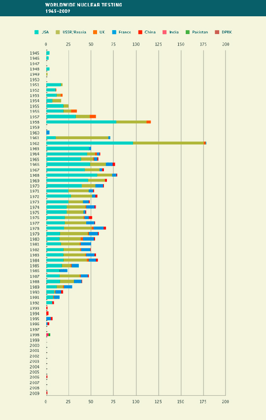
Figure 1. Worldwide nuclear testing 1945–2009 (CTBTO website). Can GPS be used to detect underground nuclear explosions?
A research team is developing a software program that uses GPS to analyze the ionospheric effect of nuclear explosions. Results would show when and where a country has conducted a secret underground nuclear test. Team members are Jihye Park, Ralph. R. B. von Frese, and Dorota A. Grejner-Brzezinska from The Ohio State University and Jade Yu Morton from Miami University.
The Comprehensive Nuclear-Test-Ban Treaty was adopted by the United Nations General Assembly in 1996, but not all nuclear countries have ratified it, including the United States, China, Egypt, Indonesia, Iran, and Israel. Also, India, North Korea, and Pakistan have not signed the treaty.
Park, a doctoral student in geodetic science at Ohio State, created the computer program to detect changes in the ionosphere from nuclear weapons testing.
A previous study showed that the ionosphere was disturbed by underground nuclear testing conducted by Russia in 1990. GPS is capable of precisely measuring the total electron content (TEC) of the ionosphere along the path between satellite and receiver at a GPS station, so Park and her team decided to begin researching the use of GPS in detecting nuclear explosions.
“Many studies have been done to monitor and model the atmosphere using GPS technology,” Park said. “Research has proven that GPS can detect natural disasters such as earthquakes or tsunamis. This study broadens those areas of study with its capability to detect underground explosions.”
Detonation of a nuclear weapon results in a shockwave that travels through the atmosphere, changing the density of charged particles in the ionosphere. “The explosions can’t hide from the ionosphere,” said von Frese, geophysicist and project leader. “Our technology would be another nail in the structure to detect explosions.”
“One of the arguments is ‘Well, how do you prove that a clandestine explosion occurred?’” said Grejner-Brzezinska, Park’s adviser and GPS World’s Tech Talk blog editor. “Now we can say, ‘Here, we have the data from GPS to show when and where.’”
According to the Comprehensive Nuclear-Test-Ban Treaty Organization (CTBTO) nuclear testing has been carried out in the past by the United States, Russia, the United Kingdom, France, China, India, Pakistan, and North Korea (see Figure 1).
Researchers, and those monitoring treaty violations, are able to target specific geographic areas that are equipped for tests, since development of a nuclear test site requires a lot of technical effort and budget. For example, the North Korean tests carried out in 2006 and 2009 were very close geographically.
“They tend to stick to the same site and reuse their facilities for nuclear testing,” von Frese said. “So a country that has previously conducted underground nuclear testing probably will reuse the site if new testing is needed.”
“They could be monitored using GPS as long as there are GPS stations nearby,” Park said.
The new GPS nuclear-detection technology was presented at the Comprehensive Nuclear-Test-Ban Treaty Organization meeting held June 8–10 in Vienna, Austria, and received press coverage that drew additional interest.
GPS Detection. The team zeroed in on a specific event to test the software, selecting a nuclear test conducted by North Korea in 2009 and using data pulled from nearby South Korean GPS stations.
Traditional detection methods for underground nuclear tests include seismic and other sensors. The CTBTO operates an international monitoring system to detect explosions with a yield of at least one kiloton. Besides seismic sensors, monitoring includes hydroacoustic sensors to monitor for shockwaves on land and in water, infrasound to detect pressure waves, and radionuclide detectors for any gas that may have been generated, though the levels aren’t always detectable.
“Even though there are four different systems available, they sometimes are unable to detect the underground nuclear explosions,” Park said. “GPS technology will make the detection validation stronger since each of them is based on a different theory. In the case of the nuclear test conducted by North Korea in 2009, only seismic and a few infrasound sensors detected the event because of their improved containment technique. Our study tracked down the 2009 event using GPS, and found it coincided with the seismic results.”
Park was able to take advantage of the well-established worldwide infrastructure already in place for GPS for her software test. The team used GPS data recorded by South Korean GPS receivers of the 2009 North Korea test. “There are a few IGS (International GNSS Service) stations in South Korea, China, and Japan. Since South Korea runs their own GPS network, I requested the data so that we could obtain data from more stations located in South Korea,” Park said.
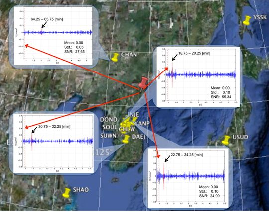
“Since the stations we chose were permanent reference stations controlled by an international organization (IGS) and a specific country (Republic of Korea or South Korea) respectively, most of them have been running continuously except for unexpected data gaps from time to time,” Park said. Figure 2 shows the GPS stations processed for the project.
With data in hand, Park was able to test her software. The results showed definite peaks from different stations at different times after the 2009 explosion. “We realized that the time of the detected peak was dependent on the distance between underground nuclear explosion and each GPS station,” Park said. Figure 3 shows four different stations’ TIDs (traveling ionospheric disturbances) that the team initially recognized.
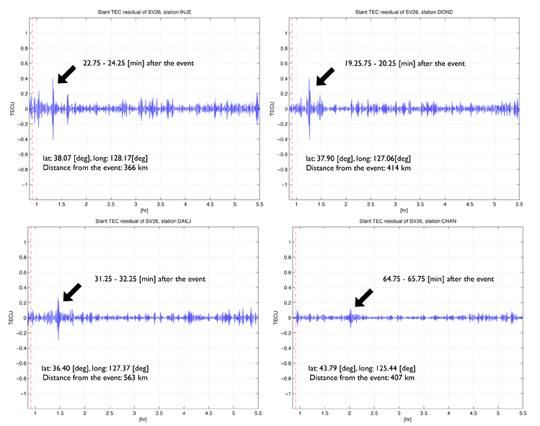
Figure 3. Traveling ionospheric disturbances (TIDs) detected at stations INJE (top left), DOND (top right), DAEJ (bottom left), and CHAN (bottom right). Click to enlarge. Ruling Out Quakes. One big challenge using GPS for ionospheric monitoring is determining the origin of an event. “Since earthquakes also disturb the ionosphere, distinguishing earthquakes from underground nuclear explosions are problematic even with GPS,” Park said. “Indeed, we only focused on examining and isolating TIDs from the nuclear explosions. We are now working to analyze the TIDs from earthquakes and compare them with nuclear TIDs.”
Besides helping to distinguish between earthquakes and nuclear-test explosions, the software may eventually distinguish between nuclear plant fallout and nuclear test fallout.
With this goal in mind, the team is analyzing the ionospheric data gathered from recent nuclear plant accidents such as the one in Japan following the earthquake and tsunami in March. “Since there were data gaps and other data issues, we have as yet nothing more to report. Hopefully, we find the earthquakes’ signature soon.”
-
Spectracom Introduces 16-Channel GPS Simulator for Receiver Testing
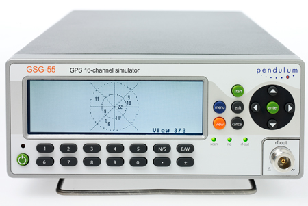
GSG-55 GNSS simulator Spectracom, a global provider of time and frequency test and measurement solutions, will make available its new 16-channel GPS constellation simulator, the Pendulum GSG-55, in March. The GSG-55 is the latest in the Pendulum line of GPS receiver test instruments and part of its solution set for receiving, distributing, and validating GNSS systems.
With the enhanced signal generating capability of the GSG-55, it is possible to simulate Satellite-Based Augmentation Systems (SBAS), the company said. Navigation systems that use SBAS can improve the accuracy and reliability provided by the GPS satellite signals alone, enabling critical applications such as aircraft navigation, and surveying and mapping. SBAS simulation (support for Europe’s EGNOS and North America’s WAAS) is a new feature in the GSG-55. It is also able to generate white noise, making it possible to test receiver sensitivity under different signal-to-noise ratios.
“Many high-end GPS applications utilize 12-channel GPS receivers. Our new GSG-55 GPS constellation simulator can fully test those receivers with additional signals for more comprehensive testing in both development and production environments,” says Staffan Johansson, product manager at Spectracom.
The GSG-55 builds on the popular Pendulum GSG-54 eight-channel simulator including accurate testing of GPS timing receivers and portability through its compact and lightweight bench-top chassis. The GSG-55 also continues the Pendulum brand hallmark of ease-of-use. As such, the entire GSG family of GPS simulators has been improved based on customer feedbac, the company said.
-
Out in Front: Welcome to Accuracy Anonymous
The following was delivered as an invited presentation at the Civil GPS Service Interface Committee plenary session, held September 20 in Portland, Oregon.
Hi, my name is Alan, and I’m an accuracy addict.
I got my first taste of accuracy back in 2000 when I started at GPS World, and discovered the vast range of very advanced things that people were doing with the signals of the Global Positioning System.
This filled me with a great feeling of elation, expansiveness, and effectiveness. I can position anything. I can track anything. I can go anywhere, and know where I am. I can direct something else to go somewhere, and have it hit exactly on target. I can examine the minute movements of the earth, the swaying of skyscrapers, the moisture content of the atmosphere, and I can know all.
I began to feel the illusion of omnipotence — of power over all.
The more I found out about accuracy, the more I used it, the more addicted I became.
Very early, I learned that advanced practitioners, such as some of the people in this room, had developed ways of taking two GPS signals, not just one, but two signals, including one that they weren’t even entitled to use, and combining them, distilling them, refining them to produce an even more potent product: high precision.
High. I was getting pretty high. Almost as high as some of you.
Because we’re all in this together. In this room, we are all addicts. And when our supply of accuracy gets cut off, or restricted, or we learn that it might soon be diminished in some way, or even that its projected future rate of increase might not be as rapid as expected, or that it might not increase at all, it might just simply stay the same — well then, we get upset.
We want to get high precision, we want to stay high precision, and we want to get higher precision.
We may have a problem with our accuracy habit.
It’s not just us, the highly educated, highly equipped, highly advanced users, with near-lifelong histories of accuracy use. Outside this room, outside this convention center and all who gather here this week, outside our offices and labs, the great unwashed masses are getting their first taste of low-grade accuracy. With their cell phones or smart phones, maybe 50-meter, maybe 15-meter, maybe even 5-meter accuracy.
They’re liking it, that first taste. Once they learn how to exploit it, and learn that higher accuracy is possible, they’re going to demand it.
And some enterprising young engineers are going to build a high-powered LBS app that needs high accuracy, just like other new apps need broadband or WiFi or 3G or 4G. If the capability exists, someone wants to make money off it.
We may be raising a generation of monsters, who will absorb our habit into their bloodstreams and into their lifestyles.
Things might get ugly. We know they’re going to change, altering the landscape in ways we may not recognize.
I’m not talking about just the social landscape, the way accuracy users behave. Not just the user segment. I’m talking about the way accuracy is produced and administered. I’m talking about
the supply of accuracy, the supply of a substance that is in high demand and to which an increasing number of people are becoming addicted.
I’m talking about the ground control segment and the space segment.Ultimately, I’m talking about who makes the decisions, who funds the decisions, who enacts the decisions, and who enforces the decisions about how much accuracy can and will be produced.
Today, we know, or think we know who those people are: the GPS Wing, the Air Force, the Department of Defense, the Administration of the U.S. government. We may think we know that those same people will be in charge tomorrow.
I’m not so sure. Revolutions have happened before.
I don’t mean to be U.S.-centric. The same developments are taking place, perhaps a bit lagged, in Europe and Russia and China. When the great mass of the Chinese market gets into using accuracy, gets the habit, you’re going to see some effects.
Returning to the United States, simply because it has the most known and most established of these systems, it is not inconceivable that some Tea Party-like movement, a groundswell should roll right up to Washington, into Congress, and say:
“Higher accuracy is possible. We are paying for GPS with our taxes, and we want you to spend that money producing and supplying us with a higher grade of accuracy. Don’t give us this talk of responsible stewards. We are calling the shots now. Just do it. Revise the ICD. Up the ante.
“Give me accuracy or give me death.”Ladies and gentlemen, I have expanded, exaggerated only slightly, and perhaps exploded the old dictum that I’ve heard attributed to Charlie Trimble, I don’t know who first said it, but it bears repeating and repeating often: accuracy is addictive.
Indeed it is. I’m here to tell you.
I was asked to give you a user perspective. I’ve chosen what is today a relatively small user segment, but a very real one, and a growing one. And most important, one that augurs for the future.
Perhaps the scenario I just imagined for you exaggerates a bit. Perhaps. I am consciously trying to push further out the boundaries of our thinking.
We’ve been waiting, some of us, for a long time for the mass market to get involved in GPS. This is now happening, bit by bit. But it has not yet fully happened. When it does, great changes will come. When LBS figures out the key to making money out of location, you’ll see changes you can’t imagine today.
I started to become aware of how pervasive and how strong accuracy addiction has grown when we experienced a succession of anomalies in the GPS constellation over the last year or so: SVN-49, the last IIR-M satellite; carrier-phase anomalies detected on SVN-48; and now SVN-62, a small variance in the L5 signal on the first IIF. “The signal variation results in no more than a 5-centimeter error with a predictable periodicity of about six hours.”
In each case, GPS performed within spec, and some therefore viewed these issues as non-issues. “What seems to be lacking is context: what relevance their findings on unspecified and unrequired signal characteristics really have to do with the real-world GPS IIF mission and requirements.”
I’ve repeated here two printed quotes in the magazine; offline, the point-counterpoint discussion grew a good deal more inflamed. Passions run high when the supply and quality of accuracy appears in question.
This might seem a minor flare-up today, off in a corner of the field: specialized scientific research spatting with industry giants and their military-industrial complex benefactors.
But today’s developing applications in aviation, ground transportation, structural monitoring, machine control, infrastructure, and more use techniques such as carrier phase that are not governed, are not even mentioned in the GPS ICD.
When LBS gets figured out, and high-accuracy LBS and vehicle navigation and crash avoidance become regularly supplied commercial services, when the dependence of financial and communications infrastructure on high precision becomes fully understood and appreciated, then you’ll see some large corporate money that has become accuracy-addicted. Imagine this room in another few years, with GM, Ford, Google, Microsoft, AT&T, and Verizon attending and very interested, very much so, in aspects of user accuracy that are not currently addressed in the ICD.
This community will change. Its needs will change. Balances of power and funding will shift. Are we prepared for that? Are we prepared to be surp
rised? Or are we prepared only to be left behind by tides of change, to become obsolete? -
GPS World: 20 Years Young, 1990-2010
Covers from 1990, 1994, and 1998.Two Decades of GNSS Products
Question: How has your product and services mix changed, with the evolution of GNSS technology and users, since 1990 (or since your company was founded, or entered the GNSS market)?
Hemisphere GPS replies:
Like GPS World, Hemisphere GPS is proud to be celebrating our 20th anniversary in 2010. Over the past 20 years, our products have evolved, and continue to evolve, from a focus on providing positioning hardware to providing complete machine-control solutions as well as related services and applications. The evolution of GNSS technology has allowed us to create a more sophisticated and more accurate product line. We have been fortunate over this period to expand our market share in a variety of new industries. As GNSS technology matures, we are expanding our sales globally by servicing existing markets and finding new markets for our products.
Spirent Federal replies:
Spirent’s first simulator contracts were for GPS L1/L2 systems. During the 1990s, most customers were interested in these two GPS frequencies, often including classified P(Y) code simulation capability. GPS modernization is a major change that continues to shape the industry today. Spirent was first to launch GPS L2C, GPS L5, and M-code test systems into the market and developed SAASM-capable simulation systems for Precise Positioning Service (PPS) receiver testing. Growing concerns about RF interference and anti-jamming have led to Spirent GPS/inertial test interfaces and the development of CRPA test systems for comprehensive wavefront testing.
To enable testing of consumer GPS, Spirent developed a range of GPS L1 C/A code simulators which went on to sell widely to a whole new group of customers. Spirent delivered GPS plus GLONASS simulation during the 1990s. Today, with a nearly full GLONASS constellation and confidence building in Galileo again, many companies are looking to improve performance through multi-GNSS-capable receivers.
Rakon replies:
Rakon started supplying the GPS market back in 1990 with 1 ppm TCXOs that were about 11.7 2 18.3 mm in size. At the time they were the smallest on the market, hand assembled, and orders were for 100,000 units per year. These larger discrete products sold between US$30- $50 per unit. In 2002 Rakon introduced the first 0.5 ppm TCXO in a 5 2 3.2 mm surface-mount package, and since then the market for PND and mobile phones has really taken off. Today the market is 100s of millions of units a year — and this is still growing fast. The products are down to 2 2 1.6 mm in size, five times the performance and a fraction of the cost they were back in 1990 (now under US$1 each).
At Rakon we’ve realized that GPS needs more than just headline frequency stability and have built an entire bespoke manufacturing process that targets the parameters that GPS is sensitive to. The mobile phone environment GPS needs to operate in today is extremely challenging. Rakon has been developing new designs in high-stability TCXO technology, to continue to develop cost-reducing solutions with unmatched performance.
Special Section Sponsors
Sponsors of this special section commemorating the 20th anniversary of GPS World publication also include CAST Navigation and ITT. The magazine thanks all advertisers over the years for their support in relaying the latest technical, system, and business news to the marketplace. GPS World reaches 133,152 core buyers across the GPS World brand: print magazine, e-mail newsletters, website, webinars, and social media.


Covers from 2002, 2004, and 2008.Two Decades of Innovation
Question: What is the most significant innovation your company has made over the last 20 years, and how does it relate to a development in GNSS technology or market?
Rakon replies:
Rakon was the first to develop the smallest 1 ppm TCXO in 1990 and led the way again in 2002 with the first 0.5 ppm TCXO. Rakon convinced the GPS chipset companies on the advantages of this level of stability while still remaining cost competitive. Today 0.5 ppm is now industry standard.
Spirent Federal replies:
Spirent has always been engaged in research and development to meet the growing user demand and provide new solutions for the latest requirements. The last five years alone have seen many significant innovations. In 2006, Spirent was awarded a contract to support the in orbit validation phase of the Galileo project. Test signals were needed to exercise the receivers for the Galileo Ground Sensor Stations and the initial “Test User Segment” receivers. Spirent developed Galileo simulators that could accurately simulate GPS with Galileo in a wide range of conditions, including error states.
In 2007, Spirent Federal won a contract to supply SDS M-code simulation systems to Rockwell Collins in support of its MUE contract with the GPS Wing. In 2008, for NASA’s Orion project, Honeywell selected a Spirent GPS/inertial simulator to emulate inertial sensor output while concurrently simulating GPS RF signals. Additionally, Spirent brought the first GPS/GLONASS/Galileo/QZSS simulator to the market and developed a CRPA test system recently selected by Rockwell Collins for comprehensive wavefront testing.
Hemisphere GPS replies:
In 2000, we launched the Outback S guidance system for agriculture. Outback S provided farmers visual guidance through a light-bar style system. At the time, GPS guidance in agriculture was in the infancy stage and due to its high cost was only accessible to a small number of users. Outback S brought GPS-based guidance to the agriculture market at a new price point and with a simple, intuitive user experience that appealed to the mainstream farmer. By the end of 2001, Outback was the number-one selling GPS guidance system for agriculture. We have since expanded on this innovation to include affordable auto-steering and continue to take pride in being “The leader in performance and value.” Today, we continue this value for performance legacy with our newest product, Outback eDriveX, which provides the highest accuracy steering available in the market at very compelling value.
Two Decades of Eager Users
Question: How have your customers/users developed or adapted over the last 20 years, as GNSS technology has developed? Or, have you changed what customers/users you sell to?
Spirent Federal replies:
Traditional users of GPS have developed to take advantage of new opportunities offered by improved and new signals, evolving technology, and research findings. The focus has shifted from getting receivers to navigate, to improving performance, systems integration, and user experience. Resilience has been a key focus for many users, who want to have not only high availability but also position information that they can trust.
In 1990 there were very few users of GNSS. Today GNSS is close to “the fifth utility,” with near ubiquitous deployment in vehicles in some countries and also increasingly in mobile phones. GNSS is used in many ways, including in innovative and unforeseen applications. Just one example is the possible use of GNSS to determine driving dynamics so that insurance premiums for more careful drivers can be set lowest!
Rakon replies:
Initially Rakon’s customers were involved mainly in marine, military, surveying, and agriculture. GNSS is increasingly becoming part of our modern-day infrastructure and services. Positioning capability is constantly being designed into an extending range of mass marketed consumer applications. Today we have many PND customers and those making products with GPS capability such as in mobile and smartphones and telecommunications. Customers have disappeared and many have changed significantly as the market has evolved; however, a core group has been with us since they started.
Hemisphere GPS replies:
In the past, the majority of our customers and users were very technically sophisticated. They were often educated in the field and demanded products solely based on position accuracy. Over time, our users have come to demand much more from our products and GNSS technology in general. Advancements in technology have also created a new category of customer who may be less technically sophisticated with the technology but who are looking for simplified solutions to complex problems. This has led us to focus our product development on more complete solutions that meet specific applications.
About This Magazine
Question: In your view, how has GPS World changed to reflect developments in the marketplace, the technology, customers’ needs, and your marketing needs?
Spirent Federal replies:
GPS World has been a valued companion for those involved in GNSS technology development. Many in the industry are deeply involved in a particular aspect of GNSS technology and find the broad, accessible perspective offered by GPS World very valuable. Many will remember reading about new signal performance first in GPS World — the first GIOVE Galileo signals from space and new Compass signals, for example. Key themes have also included vulnerability of the GNSS signals, from the Volpe Report through to analysis of the recent SVN-49 issues.
Hemisphere GPS replies:
GPS World has done a fantastic job in highlighting the evolution from GNSS technology to the myriad of both consumer and industrial applications the technology now enables. The publications are timely and consistently produce a credible resource for industry professionals. From a marketing perspective, GPS World’s expansion into online media has broadened its scope and circulation.
Rakon replies:
Originally the publication focused on the U.S. Global Positioning System. With the advent of others such as Galileo, GLONASS, and Compass, the publication has evolved to cover all GNSS systems.
-
GNSS Vulnerability and Alternative PNT
As NextGen air traffic management increasingly relies on GNSS for safety-critical functions, some form of backup is needed in the event of GNSS signal loss, whether due to intentional jamming or other causes.
A group working under the auspices of the Federal Aviation Administration (FAA) Navigation Services Directorate recently prepared a study assessing non-GNSS navigation system architectures to provide alternate positioning, navigation, and timing (APNT) services for aviation users, to mitigate GNSS vulnerability to radio frequency interference (RFI). The APNT architecture would be based on selected elements of today’s terrestrial navigation network, possibly upgraded, plus new elements anticipated for the 2025 timeframe.
This article summarizes the scope and initial results of the study; to download the full paper, visit env-gpsworld-integration.kinsta.cloud/alternativePNT. As a result of the 2001 Volpe Vulnerability Study and subsequent U.S. government policy on PNT services provided by GPS, the FAA has begun investigating APNT concepts by which the safety, security, and efficiency of the U.S. National Airspace System (NAS) can be maintained in the event of a loss of GPS-provided PNT services. The sought-after APNT network should be cost-effective based on likely aircraft equipage in the 2025 timeframe.
The FAA recognizes that during migration from the current NAS to the Next Generation Air Transportation System (NextGen), reliance on PNT services will increase to support area navigation (RNAV), digital communications, and enhanced surveillance services. This paper, presented by the FAA to the International Civil Aviation Organization’s (ICAO’s) Navigation Services Panel in May, identifies three major areas of research and analysis. The APNT work represents a constructive response to concerns raised by the simultaneous 9/11 terrorist attacks and the Volpe Report on GPS vulnerability.
The first area of research proposes to investigate current distance measuring equipment (DME) to see if better RNAV services can be provided to current and future users, and to mitigate the possible problem of over-interrogation as demand on the system grows. The second area will investigate multi-lateration to see how the services based on systems currently being planned and fielded could be expanded or enhanced by synergy with other ground-based navigation systems such as DMEs.
The third area of interest will investigate the use of the current and future DME network, and potentially other ground-based equipment, to provide a robust RNAV pseudolite system broadcasting in the current DME L band. This third alternative receives the bulk of the attention of this two-page digest of the full paper.
Background
The United States is pursuing the NextGen air traffic modernization program to support a predicted increase in operations by a factor of 2–3 by 2025. Many of the new capabilities depend on PNT services provided by GNSS. Specifically, performance-based navigation (PBN) and automatic dependent surveillance broadcast (ADS-B) will be based on GPS with satellite-based augmentation systems (SBAS) and ground-based augmentation systems (GBAS). PBN and ADS-B will, in turn, support trajectory-based operations, area navigation (RNAV), required navigation performance (RNP), precision approach, closely spaced parallel operations, and other operational improvements.
As NextGen modernization and implementation progresses, U.S. NAS dependence on GNSS services will increase. Appropriate mitigations for GNSS vulnerability to RFI also must be assessed and implemented where necessary.APNT Assumptions
The study group established a set of assumptions to guide the analysis activity. Key among the 13 assumptions were:
- In 2025, there will be “RNAV everywhere and RNP where beneficial.” There will likely be many different variants of RNAV and RNP that are yet to be defined.
- APNT is a means to continue RNAV and RNP operations to a safe landing during periods when it is discovered that GNSS services are unavailable, due to interference.
- Users equipped for APNT will be able to continue conducting RNAV and RNP operations (dispatch, departure, cruise, arrival) during the GNSS outage after the transition to APNT.
- Users not equipped for APNT may not be able to continue RNAV and RNP operations in areas where GNSS is required during the GNSS outage.
- APNT service performance may not be equivalent to GPS performance.
- At least one instrument landing system will be retained at airports wherever required for safety or economically justified.
Pseudolite Multi-Lateration
This article passes over the paper’s discussion (see link cited earlier for full version) of DME network optimization and passive wide-area multi-lateration (WAM) to take a brief overview of the pseudolite-based multi-lateration.
As shown in Figure 1, the pseudolite (PL) architecture allocates the position and integrity functions to the aircraft, similar to how GPS receiver-autonomous integrity monitoring works. The PL alternative would leverage all of the existing 1,100 DME facilities plus the planned ADS-B ground-based transceiver (GBT) facilities to provide a combined network of approximately 1,900 sites.
As shown in Figure 2, the PL architecture requires the GBT and DME sites to be synchronized to a common time standard so each facility can generate and transmit a heartbeat message consisting of the station identification and an accurate time stamp. The ADS-B in avionics would host the position calculation and integrity monitoring functions and pass this information to the aircraft navigation over a new interface, if GPS becomes unavailable.
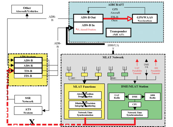
Figure 2. Multi-lateration (MLAT) alternative block diagram. The potential advantages of this alternative include a simpler architecture that does not require a ground system to compute the position of the aircraft. A common non-GNSS or robust GNSS time reference is required.
Straw Man Signal Design
The authors propose a straw man signal design for the broadcast of one-way ranging signals from existing DME transmitters. The goal is not to provide a final design for such a signal. They recognize that many modifications and improvements will be required to bring such a function to fruition. Rather, they offer the proposal as a catalyst for the community, and hope that it will serve as a starting point for a vigorous discussion on this critical topic.
Signal design is directed at these goals:
- The new signals should be added to the existing broadcast from operational DME beacons without significant degradation to the two-way ranging accuracy provided by the DME beacon to legacy users. The new signals would overlay the existing replies that complete the traditional two-way DME transactions. More specifically, they could be implemented by triggering existing beacon with requests from a pseudo-aircraft located near the operational DME beacon. Thus, they hope to avoid any changes to existing ground hardware and by so doing realize benefit from the entire set of DME beacons in operation today.
- The new signals should provide one-way ranging to modified avionics. The authors do not wish to modify the ground equipment, but recognize that one-way ranging from a DME station will require new avionics.
- In addition to one-way ranging, the new signals should also support a modest data capability. This data would include the DME location, DME identification, time information, and a parity field to ensure data integrity. The proposal targets a data capacity around 150 bits per second, because similar capacity has served well for other one-way ranging systems such as GNSS and SBAS.
- Finally, the new signal should also enable source authentication. The authors feel that signal authentication is needed, becau
se radio navigation may be subject to electromagnetic attack in the decades ahead.
The authors then describe and illustrate in seven figures the definition of a DME chip, a do-no-harm criterion, synchronization sequence, data field, data erasures and errors caused by competing channel traffic, data content, and source authentication. They indicate that they are looking at other signal alternatives for the DME band as well. These alternatives would make more liberal use of spread-spectrum technology.
Authors of the APNT study were Leo Eldredge (FAA), Per Enge (Stanford), Mike Harrison, Randy Kenagy, Robert Lilly (all with Aviation Management Associates), Sherman Lo (Stanford), Robert Loh (ISI), Mitch Narins (FAA), and Rick Niles (MITRE CAASD).