The new digital clinometer and attitude attribute type available in Touch GIS. (Image: Touch GIS)
Touch GIS has introduced a digital clinometer tool to assist field geologists in recording strike and dip readings.
Version 1.3 of the app also features a new “attitude” attribute type, which makes it easy to record and display these readings on the map.
“We’ve been testing these new features with a number of field geologists, and we’re excited to finally be launching it broadly,” said Joe Wilson, head of products at Touch GIS. “While Touch GIS is valuable for a wide variety of field data collection, we’ve found that it’s especially popular with geologists.”
As more and more field work is being done on mobile devices, it’s important to integrate them onto a single platform for collecting and sharing field data. Touch GIS has a mission to provide the most robust data collection featureset for mobile field mapping.
Touch GIS also features powerful file support for industry-standard types, offline mapping capabilities, and accurate drawing tools for points, lines and polygons.
Touch GIS has a free tier that allows users to explore a majority of its features. Premium subscribers can cache maps for offline use and export collected data.
Septentrio has entered into a commercial agreement with Sapcorda, a global provider of sub-decimeter GNSS corrections.
Through the collaboration with Sapcorda, Septentrio will pioneer an no-hassle corrections integration into a new line of products for the high-accuracy industrial market.
These new products will consist of Sapcorda’s SAPA Premium corrections integrated directly into Septentrio’s latest GNSS receiver technology. The result is sub-decimeter accuracy, which is available to users right out of the box. This significantly simplifies the user’s GNSS receiver set-up process and eliminates the hassle of corrections service subscription and maintenance.
Such GNSS receivers acquire corrections via internet as well as via satellite broadcast and deliver reliable, broadly available sub-decimeter positioning to high-volume industrial applications.
Sapcorda integration program
Sapcorda release its SAPA augmentation service integration program on May 14, following the launch of its SAPA Premium service. The integration program targets companies integrating GNSS chips or receivers and looking to enable their systems to perform in high-accuracy mode.
The program offers step by step service integration and proof of concept guidance for upgrading the integrators’ GNSS systems to deliver down to centimeter-level positioning accuracy.
The program also includes the offering of free service data, used to validate positioning performance on the target application. The program participants also receive commercial support for introducing the correction data on their marketed products.
The SAPA service is delivered using optimized data format and can be integrated by modern or traditional high-accuracy receivers compatible with open standards such as SPARTN and RTCM.
Sapcorda’s SAPA services are designed to bring high-precision GNSS positioning to mass market, as well as general industrial and automotive applications. The correction data stream is optimized for homogeneous performance and end-to-end data security with continental coverage in the United States and Europe.
The service data transmission also provides unmatched low bandwidth consumption, with broadcast transmission via direct IP connection or geostationary satellite signal (L-band).
Sapcorda was established in 2017 to provide an open approach to a safe, broadly available and scalable corrections service. By adding Sapcorda’s SAPA service to its corrections portfolio, Septentrio begins offering sub-decimeter accuracy with quick convergence time anywhere in the U.S. and Europe.
Autonomous vehicles, robots
“This collaboration allows both companies to bring innovative solutions, inspired by the growing market of autonomous vehicles and robots, to the high-accuracy industrial markets,” said Jan van Hees, business development director at Septentrio. “By integrating Sapcorda’s SAPA service into our products, we are completely removing the hassle of managing corrections for the customers. This means faster set-up times and worry-free, always-on high-accuracy positioning throughout the whole receiver lifetime.”
“At Sapcorda our focus is on providing a high-accuracy service suitable for demanding applications where both performance and safety is critical. This includes land robots, UAVs, logistic applications and autonomous vehicles,” said Botho Graf zu Eulenburg, CEO at Sapcorda. “Septentrio’s field-proven high-precision GNSS receivers and their focus on reliability and robustness aligns perfectly with our mission and the capabilities of our SAPA services.”
This broadens the range of Septentrio’s existing GNSS solutions, allowing the company to serve a wide range of customers with various requirements in terms of accuracy, operation location and scalability. Read Septentrio demystifies GNSS corrections for more about GNSS corrections and correction methods such as Sapcorda SAPA (PPP-RTK) service.
Fortem Technologies has completed the first phase of the U.S. Department of Transportation’s Unmanned Aircraft Systems Integration Pilot Program (UAS IPP) in North Carolina.
As part of the program, Fortem is conducting tests to monitor the airspace around WakeMed Hospital in Raleigh, tracking manned flights alongside the UPS Delivery Corridor, and delivering medical test samples via unmanned drones. Fortem has been using its TrueView radar and SkyDome software system to ensure UAS operations and drone deliveries do not interfere with medical helicopters flying in and out of the area, as well as alert drone operators of any potential non-cooperative aircraft in the vicinity.
According to the company, it was able to accurately and consistently track incoming medical helicopter traffic, providing real-time alerts to Airmap, an unmanned service supplier.
“By monitoring the airspace and creating a service that ensures the safe use of unmanned air vehicles, we will expand from these initial drone deliveries to greater geographical reach and more sophisticated roles for unmanned drones,” said Adam Robertson, CTO of Fortem Technologies. “With Fortem’s ability to offer real time data and analysis of airborne threats, we can start to see additional support for things like search and rescue operations, first responders, and increased shipments of critical supplies to remote locations. None of this can happen without the trust that our systems are effective and safe.”
The North Carolina Department of Transportation (NCDOT) Division of Aviation partners, including WakeMed Hospital, are testing drone operations that will soon go beyond a pilot’s visual line of sight to provide efficient and safe drone operations with the ultimate goal of helping to improve healthcare access for all North Carolinians.
“Ensuring the safety of manned aviation is paramount for unmanned flight operations, yet successful coordination of the two is not an easy task,” said Basil Yap, UAS program manager at NCDOT. “The phase one testing has shown promising results and we are hopeful the phase two operations will provide the information we need to receive a beyond-visual-line-of-sight waiver from the Federal Aviation Administration.”
Fortem will continue to provide situational awareness and secure the airspace into the next phase of the program, the company said. NCDOT, as part of the USDOT UAS IPP, will continue to support its partners’ operations at WakeMed throughout the year until the program’s conclusion in October.
GPS World is offering the latest news and updates concerning the coronavirus (COVID-19) pandemic as it affects the GNSS/PNT industry. Read a message from GPS World here.
Geospatial Solutions and GPS World are offering the latest news and updates concerning the coronavirus (COVID-19) pandemic as it affects the geospatial, mapping and GNSS/PNT industries. Read a message from GPS World here.
The Federal Aviation Administration (FAA) and the Association for Unmanned Vehicle Systems International (AUVSI) will host the 5th annual FAA UAS Symposium virtually, rather than in-person in Baltimore. The event will take place June 16-18.
This decision was made as a result of the ongoing concerns caused by the COVID-19 pandemic, the organizers said.
The FAA and AUVSI also will be hosting a series of virtual events that will address the content already planned for this year’s program. The fist will take place in early summer and will focus on UTM and international UAS integration. The second will take place in late summer with a focus on updates to the Integration Pilot Program and public safety operations.
According to organizers, those registered for the 5th annual FAA UAS Symposium will receive a separate message in the coming weeks to confirm options for participation in the virtual events.
Those selected as speakers for the 5th annual FAA UAS Symposium will receive a separate message from AUVSI’s Industry Education Team to confirm participation, as well as any schedule changes.
Altitude Angel, a London, U.K.-based unmanned traffic management (UTM) technology provider, is releasing an open-sourced project, Scout.
Scout’s hardware and firmware enable drone manufacturers, software developers and commercial drone pilots to quickly connect to its global UTM.
Primarily intended for use in commercial and industrial drone applications, Scout provides the capability to securely obtain and broadcast a form of network remote ID, widely seen as a necessary step for enabling routine drone use and flights beyond visual line of sight.
Because it is open source, both the hardware and the firmware can be enhanced and incorporated into a virtually limitless set of scenarios, according to Altitude Angel.
Altitude Angel also has made available a surveillance API that allows integrators to both share and receive flight data from a variety of sensors and devices in near real time, providing a comprehensive real-time picture of the airspace.
While many remote ID systems are broadcast only, Scout offers two-way communication and is fully open-sourced. The ability to talk back to the drone enables the Altitude Angel UTM service to help the drone avoid collisions with other aerial vehicles, or restricted airspace.
From launch, Scout will use identifiers obtained freely from Altitude Angel’s GuardianUTM platform. It will work in combination with a pre-flight (flight-plan sharing) service and is supported through integration with Altitude Angel’s Tactical Conflict Resolution Service.
Scout will enable the drone to report its real-time location using GPS-type sensors and relay this data via a secure, encrypted mobile communications link across 3G, 4G and 5G networks to Altitude Angel. It is powered by an internal rechargeable (via micro USB) lithium battery.
Altitude Angel has also provided reference design plans for the case that can be 3D printed. Scout has been designed to satisfy emerging network remote ID standards, such as ASTM.
Because the firmware is open source, the telemetry can be sent to other systems as required by the implementor.
A two-wire I2C upgrade to the circuit schematics, plus version 2 of the firmware (both scheduled for June), will subsequently enable the full two-way communication between the Scout device and the drone’s onboard systems, allowing the drone to respond directly to information received from the UTM.
In the interim, early adopters will have the opportunity to begin to integrate with Altitude Angel’s UTM services, test the hardware and test communication. Position data Altitude Angel receives from Scout is then automatically used by its Flight Information Management System (FIMS) to help provide traffic deconfliction.
Plans, firmware and schematics can be accessed via the Altitude Angel GitHub repositories.
The Institute of Navigation (ION) will be hosting a complimentary webinar, “Impact of Sample Correlation on SISRE Overbound for ARAIM,” at 12 p.m. ET on May 28.
This topic was originally presented at ION GNSS+ 2018 and published in the Spring 2020 issue of Navigation, Journal of the Institute of Navigation, Volume 67, No. 1, pp 197-212, by Dr. Santiago Perea Diaz, Prof. Michael Meurer and Dr. Boris Pervan.
According to ION, this paper analyzes the effect of error correlation on the SISRE bounding for GPS and Galileo satellites. For a given period of data collection, it computes the effective number of independent samples contained in a dataset applying an estimation variance analyses. Results show that the time between effective independent samples is highly dependent on the constellation and onboard clock type. On one hand, GPS satellites equipped with Rubidium clocks exhibit significantly longer error correlation than those with onboard Cesium clocks. On the other hand, Galileo satellites show substantially shorter correlation time among samples with less variability on a monthly basis, ION added.
This paper also introduces a methodology to compute SISRE bounding accounting for the limited number of independent samples, ION said. Using a Bayesian approach, it computes the so-called uncertainty factor by which the Gaussian distribution needs to be inflated in order to account for the observation data independence.
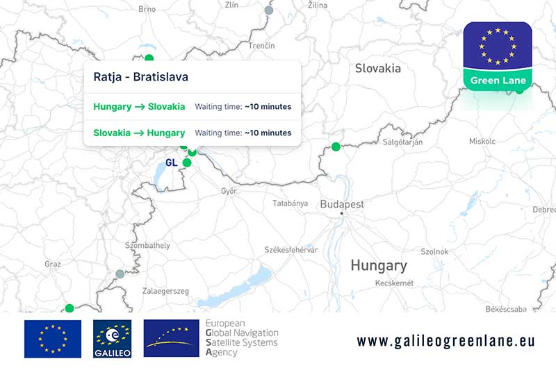
The European GNSS Agency (GSA) has collaborated with the European Commission to develop the Galileo Green Lane app, a mobile solution designed to facilitate the free movement of freight, reduce waiting times at European Union (EU) borders and prioritize essential goods during the COVID-19 pandemic response.
According to GSA, for border control authorities, the app provides a real-time visualization of the situation at border crossings, along with regular updates on the traffic flow situation.
For truck drivers, the app provides a real-time visualization of borders, through an EU-wide map indicating crossing times. This enables logistic companies and drivers to better prepare their routes, having advance knowledge of the waiting time at each border crossing, GSA said.
The app also offers a real-time overview of border traffic hold-ups, built on the foundation of Sixfold’s COVID-19 map. In mid-March, Sixfold began to provide supply chains, retailers and shippers with a free live border crossing map, which is updated in real-time.
“With the Galileo Green Lane app, the GSA is fulfilling its mission to address economic and societal challenges by leveraging the European GNSS capabilities,” said Pascal Claudel, acting executive director at the GSA.
The app has been tested at border crossings in Hungary and the Czech Republic, while other countries, including France, Greece, Italy, Romania and Spain, are about to start testing, GSA added.
Esri will be providing a COVID-19 Response Package for free to all nonprofit organizations responding to the pandemic. According to Esri, this includes data, templates and solutions that are accessible through Esri’s Disaster Response Program.
By mapping data with capabilities such as spatial analysis, Esri’s software allows organizations to track where COVID-19 cases are spreading, and — through predictive modeling — determine where additional capacity will be needed. Using data visualization in maps and dashboards, nonprofits can see affected populations, share information with stakeholders virtually and measure the impact of their response efforts, Esri said.
“Esri enables us to identify vulnerable communities, whether they currently have unmet needs or appear to have a thin cushion with which to absorb a crisis,” said Raj Kamachee, Team Rubicon CTO and CIO. “Thanks to this wealth of location-based data, we have responded not only reactively, but have also been able to reach out proactively to these vulnerable communities, establishing a relationship during ‘blue skies’ so they have someone to call when disaster strikes.”
According to Esri, it has supported more than 10,000 nonprofits to advance their missions with geospatial data and tools through the Esri Nonprofit Program, which was launched in 2010.
“It’s never been more critical to ensure that nonprofits have the solutions that will enable them to target and serve vulnerable populations, understand disease spread, gauge their effectiveness and engage their communities,” said Jack Dangermond, Esri founder and president. “Our company was founded as a nonprofit, and so we share a deep commitment to the goals and mission that these organizations pursue.”
Founded in 1969, Esri provides geographic information system software, location intelligence, and mapping.
New Matrice 300 RTK and Zenmuse H20 series cameras ready for new generation of work, including digitalization and artificial intelligence (AI)
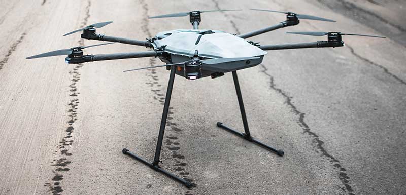
DJI has unveiled its most advanced commercial drone platform, the Matrice 300 RTK (M300 RTK), along with the Zenmuse H20 Series, a hybrid, multi-sensor camera.
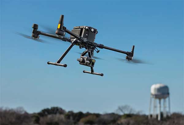
The Matrice 300 RTK UAV from DJI is designed for the next level in data collection and site inspection. (Photo: DJI)
DJI engineered the all-in-one, high-tech solution for areas of work never explored before in precise aerial inspections and data-collection missions.
“With the M300 RTK flying platform and the Zenmuse H20 camera series, we are providing a safer and smarter solution to our enterprise customers” said Christina Zhang, senior director, Corporate Strategy at DJI. “This solution sets an entirely new standard for industrial UAV solutions, significantly enhancing operations across public safety, law enforcement, energy, surveying and mapping as well as critical infrastructure inspections.”
The M300 RTK is the first DJI product that integrates modern aviation features, advanced AI capabilities, six directional sensing and positioning system, a UAV health management system, and 55 minutes’ flight time.
The drone platform has AES-256 encryption and an IP45 weather-resistant enclosure. It has a built-in all-new OcuSync Enterprise transmission system that provides a triple-channel 1080p video transmission signal reaching up to 15 km away.
The M300 RTK can support up to 3 payloads simultaneously and has a maximum payload capability of up to 2.7 kg.
“For our teams working in the oil & gas industry, performance and safety are not optional,” said customer Adam Serblowski, Robotics Theme Lead at Shell. “We cannot compromise on our pursuit of utilizing the best and most efficient tools available. The DJI Matrice 300 RTK proves to be an ideal upgrade over the existing DJI product line, and it helps us to further enhance the benefits of our drone programs. Our productive partnership with DJI will continue to help elevate safety in the world’s largest industry.”
With the Zenmuse H20 Series Camera
Combined, the M300 RTK and Zenmuse H20 Series solution offers users two intelligent ways to collect data:
Smart Pin & Track. Intelligent functions that enhance synchronization of aerial intelligence in coordinated missions. It includes PinPoint, a function that allows users to mark the subject of interest and instantly share the precise location data to a second operator or if necessary to ground teams via DJI FlightHub; and Smart Track, which allows users to automatically detect and track a moving object, even at extreme distances, while synchronising the subject’s dynamic location in real time.
Smart Inspection. A new set of features developed to optimize routine data collection missions such as power lines, railway and oil and gas inspections. It consists of Live Mission Recording for recording sample automated missions in real time; AI-Spot Check, which enables data collection from exactly the same location every time, greatly improving the accuracy of automated missions. After photos from a sample waypoint inspection mission have been recorded, operators are able to mark the subject of interest. During subsequent automated flight missions, AI algorithms perform a comparison between the marked subject and current live view, thus correcting the camera orientation accordingly to deliver accurate and consistent results; and Waypoints 2.0 — an improved mission planning system offering up to 65,535 waypoints, while supporting an array of consecutive actions, 3rd party payloads, and more.
Aviation-Grade Situational Awareness. Inspired by today’s modern aircraft, the M300 RTK features a Primary Flight Display (PFD) that merges real-time flight and navigation data into one integrated display. Besides standard telemetry data like altitude and speed, the M300 RTK PFD provides obstacle data for visualising nearby obstacles during flight, enabling pilots to adjust flight trajectory if needed. These enhancements allow users to keep track of the aircraft while further enhancing the pilot’s situational awareness.
Dual-operator mode. New to DJI’s commercial drone platforms and exclusive to the M300 RTK, is Advanced Dual Operator Mode – multi-pilot control protocols that enable the execution of missions with enhanced safety, reliability and flexibility.
The M300 RTK, when controlled by two pilots, gives each pilot equal access to gain flight-control priority, the transfer of which is displayed by a series of icons on the DJI Smart Controller Enterprise. If one pilot becomes compromised or their controller loses battery or connection, the other pilot gains full control over the M300 RTK and its payloads.
When training new pilots, the teacher/main pilot can safely take over flight control if necessary.
Improved safety and reliability
The M300 RTK comes with new and improved safety and reliability enhancements, including:
AES-256 Encryption: for secure data transmission of the command & control uplink and video transmission downlink.
AirSense (ADS-B technology): for enhanced airspace safety.
Anti-Collision Beacon: for increased aircraft visibility, especially in low-light conditions.
IP45 Protection Rating & Self-Heating Battery: for adverse weather conditions (-20 to 50° C).
6 Directional Sensing and Positioning System: offers a maximum detection range of up to 40 m horizontally, with options to customize the aircraft sensing behavior via DJI Pilot.
As with modern-day jetliners, the M300 RTK offers an integrated UAV Health Management System (UHMS) to optimize fleet maintenance. It records the aircraft’s flight data throughout its entire lifecycle, and utilizes the drone’s hardware and software systems to understand current aircraft performance and determine when it should be serviced. Taking advantage of this new system, users can get a quick overview of all critical aircraft systems, manage firmware updates across an entire fleet, track pilot hours and review flight missions.
DJI Zenmuse H20 Series
The new camera payloads are designed to improve mission efficiency. The Zenmuse H20 series offers DJI’s first Hybrid multi-sensor solution, allowing capture of any kind of images for industrial applications and public-safety missions where efficient time management and immediate access to multiple layers of visions are paramount.
The H20 Series is IP44 rated, which protects enclosures from splashes of water from any direction.
The H20 series comes in two versions:
The H20, a triple sensor with a 20-MP, 23x hybrid optical zoom camera, a 12-MP wide camera, and a laser range finder covering distances from 3 to 1200 meters
The H20T, a quad sensor that adds a 640 x 512 radiometric thermal camera, allowing operators to see what is invisible to the human eye using high thermal sensitivity at 30 frames per second video definition.
Integrated user interface
To enable pilots to operate so many sensors at once, the accompanying DJI Pilot app interface was redesigned. The new user interface lets pilots quickly switch between cameras and simplifies the process of zooming in and out by letting pilots preview the zoom field of view on top of the wide angle or thermal camera footage.
With a multi-sensor integrated user interface, the Zenmuse H20 series allows users to smoothly switch between wide, zoom or thermal cameras. It also includes features for maximum flexibility when used on time-sensitive missions.
High-Res Grid Photo: Captures in one snap detailed imagery of defined subjects with the help of a custom grid. The images can be stored for later detailed inspection.
One-Click Capture: Captures videos or photos of up to three cameras simultaneously without having to manually switch between camera views or repeat a mission.
Night Scene: Gains clearer visibility when lighting conditions are not optimal.
The M300 RTK and Zenmuse H20 series are available for pre-order from official DJI Enterprise dealers and will start shipping in Q2 2020.
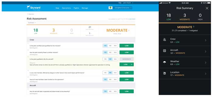
Skyward has released a new risk assessment tool for its Aviation Management Platform, which is designed to help drone program managers proactively identify and document critical risks to an operation.
For assessing risk, users answer a series of risk questions developed by Skyward’s drone experts and based on aviation best practices. Each answer is assigned a risk level: low, moderate or high. As each question is answered, an overall risk summary score is generated based on the highest level of risk present, Skyward said.
Photo: Skyward
Users can also add mitigation for any risk level by adding explanations and adjusting the risk levels. The mitigated risk will be noted in the summary, and the note will be synced across the Skyward software platform.
Skyward, based in Portland, Oregon, develops drone programs for industries such as construction, industrial inspection, media, insurance, real estate, mining, precision agriculture and more. Skyward was acquired by Verizon in 2017.