The webinar, sponsored by Nearmap, takes place June 25 at 1 p.m. EDT / 10 a.m. PDT / 7 p.m. (1900h) Central European Time. Registration is free.
Managing and protecting the nearly 31,000 acres of the preserves is no small task, so the ability to see the environment at scale in crystal-clear clarity is a must. Aerial imagery provides an “eye in the sky” to get better context of truth on the ground.
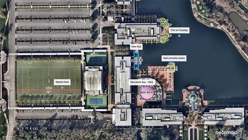
Lake County Forest Preserves uses Nearmap aerial imagery to:
monitor and track change over time with historical and current captures
assess and address invasive species growth with high-resolution imagery
manage remote work challenges during COVID-19 to locate assets.
Joining Brett Clark of Nearmap are three experts from Lake County Forest Preserves.
Nick Spittlemeister GIS Analyst, Planning and Land Preservation Dept. Lake County Forest Preserves District (IL)
Nick Spittlemeister has been with Lake County Forest Preserves since 2016, working to create an enterprise solution that employs web GIS in all facets of the organization. He helped the district secure a license with Nearmap in 2018 and has deployed it across their GIS system, from Desktop software to web applications and native apps. He has been using GIS for more than 15 years and holds a bachelor’s degree in geography from Northern Michigan University.
Dave Cassin Manager of Landscape Ecology Lake County Forest Preserves District (IL)
David Cassin’s remote sensing training began in the US Navy (1990-94) where he was trained as an Intelligence Specialist / Air Photo Interpreter, put into practice during Operation Desert Shield / Storm. Post military service, he continued his craft in college with incorporation of ArcGIS. He combined his skillset and his love of nature by getting a degree in Natural Resource Management. Integrating remote sensing skills into landscape scale restoration projects by utilizing historical air photos and land survey data, he is able to determine historic land uses and alterations. Specific to Nearmap, he was able to map populations of Phragmites australis (an invasive species in Illinois) by utilizing the fall 2019 Nearmap imagery remotely during the COVID-19 stay at home order.
Kevin Kleinjan Senior Engineer Lake County Forest Preserves District (IL)
Kevin has utilized aerial imagery and geospatial technologies for over 25 years to inform and support planning and infrastructure related decisions. He utilizes Nearmap’s high-resolution imagery with multiple captures throughout a calendar year to analyze and update infrastructure assets quickly and accurately from both the office, and in the field using mobile devices. This enables him to efficiently manage the District’s sign shop, site amenity and heavy equipment crews. He has dual degree in Landscape Architecture and Geography from South Dakota State University and is a Registered Landscape Architect in Illinois and Wisconsin.
Brett Clark Senior Account Executive Nearmap Brett graduated from Brigham Young University with a degree in communications. He was employee #2 for Nearmap, U.S., and focuses primarily on serving the public sector – both state and local. Brett lives in the Indianapolis area with his wife and three daughters.
The ability to capture and evaluate truth on the ground through aerial imagery is an ever-growing industry, thanks to the proliferation of UAVs and access to imagery on demand and online. Yet obstacles remain that could prevent organizations from capturing location intelligence.
For organizations that require timely, accurate and current aerial imagery, an additional capture program outside of drones could be necessary. One company, Nearmap, flies fixed-wing aircraft two to three times per year over 430 urban areas across the United States. Using proprietary camera technology, Nearmap captures aerial data in a variety of formats: vertical, oblique and 3D. The location content is then delivered to customers via a web browser application and can be easily integrated into GIS/CAD applications.
A mid-size tech company in New Mexico using a drone to capture digital surface model data ran into two obstacles: proximity to no-fly zones at Albuquerque International Airport and need for image consistency over an entire metro area. With a project due date looming, the company turned to Nearmap, which provided the necessary image data around the airport, as well as historical imagery. With the Nearmap data, the company was able to speed project planning from design to project completion.
Nearmap aerial imagery also provides data at scale (an entire city, not one city block). The clarity of the imagery is 2.8-inch ground sample distance, providing optimal data for seeing truth on the ground.
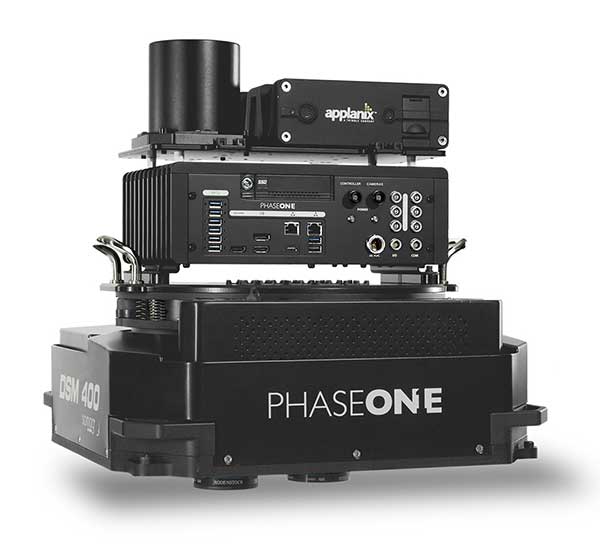
Phase One Industrial has launched a 280-megapixel aerial photogrammetric system, with an image coverage width of more than 20,000 pixels.
The large format enables unprecedented high-quality aerial survey productivity, the company said. Compact and lightweight, the new aerial mapping solution can reduce operating costs and produce better returns on investment than today’s traditional large format systems.
The Phase One Industrial 280MP Aerial Solution consists of an iXM-RS 280F large format camera, Applanix GNSS/IMU receiver (POS AV series), Somag gyro-stabilized mount (DSM 400), Phase One iX Controller and iX Flight Management software.
The system is a large format camera system that easily integrates with the DSM400 gyro-stabilized mount, creating a compact and lightweight system for use in a wide range of aircraft.
At the system’s heart is the iXM-RS 280F, a dual-lens metric camera with 90mm lenses for capturing RGB information, providing precision imaging. Adding a near infrared (NIR) camera generates a 4-band configuration, most useful in agriculture, forestry and pipeline monitoring.
The iXM-RS 280F camera generates a central projection image from two 150MP nadir images with equal ground resolution. The cameras’ backside illuminated CMOS sensor supports very high dynamic range at 83dB. Its high light sensitivity provides superb image quality in challenging low light conditions, enabling operators to take advantage of more flight hours per day and more flight days per year.
“Our 280MP Aerial Solution is a bold and innovative approach to solving customers’ demands for affordable and reliable aerial mapping performance,” said Dov Kalinski, general manager, Phase One Industrial. “Previously, opportunities in the aerial mapping business were restricted due to high cost of equipment and limited aircraft options. While pioneering superior image quality, Phase One Industrial is creating more profitable possibilities in this exciting and important market.”
This image of Wales is color-coded to show the relative height of the land. (Image: Bluesky)
Aerial mapping company Bluesky International has been awarded a contract by Natural Resources Wales, on behalf of Welsh Government, to capture a high-resolution laser mapped aerial survey of the whole of Wales.
Working alongside Natural Resources Wales and the Welsh government, Bluesky will capture the data at a resolution of 2 points per metre before processing and delivering lidar data for more than 20,000 square kilometers of rural and urban landscapes.
The Bluesky lidar data will be employed in a range of policy areas including flood modeling, forestry management, coastline monitoring, urban planning and archaeological conservation.
In addition to use internally by Welsh Government and Natural Resources Wales, the lidar data will also be made publicly available in due course, via Welsh Government’s Lle Geo-Portal website and Bluesky’s Mapshop.
“Historically, lidar data has been acquired over Wales at various points in time from the 1990s onwards,” said Paul Isaac, project manager at Natural Resources Wales. “However, since these datasets have been collected for different reasons a patchwork of data exists that is inconsistent in terms of capture technology, coverage and resolution. Also, many of the high-altitude, mountainous areas have not been captured at all resulting in key habitats and ecosystems remaining unmapped.”
“This pattern of largely uncoordinated acquisitions would likely have continued with different programmes and projects funded from various sources,” he added. “Therefore, rather than different public sector bodies securing data individually — leading to inefficiencies and discrepancies — Welsh Government proposed to capture one consistent dataset to cover the whole country. A further key driver for the projects is the wider economic benefit as organizations and individuals will no longer have to fund separate data capture.”
Bluesky was awarded the National Lidar for Wales contract following a formal tender process with responses evaluated on technical ability as well as price. All tenders were required to provide a detailed methodology of how they would complete the project to the published specification.
“Bluesky was able to provide evidence that they could provide the required services at a competitive price,” Isaac said. “Bluesky also showed they had extensive experience in this field having successfully delivered a number of related projects.”
“We are delighted to be working with Natural Resources Wales on this nationally significant project,” said Rachel Tidmarsh, managing director of Bluesky International. “As a team, we have great experience delivering large scale projects of this nature to the required specification and timescales.”
Vexcel Imaging, a provider of aerial imagery data, large-format aerial cameras and photogrammetry software, has signed a definitive agreement to acquire the imagery sourcing group from Verisk’s Geomni business.
The acquisition will combine Geomni’s imagery surveying and content-related teams and assets into Vexcel. Verisk, a data analytics provider, will be a minority owner in Vexcel with full access to all aerial imagery libraries.
The combination of Geomni’s fleet of fixed-wing aircraft and aerial operations, mapping business and oblique aerial image library together with Vexcel’s sensor business and data program will create a world-leading geospatial data library.
Geomni’s analytics team and assets will remain part of Verisk and continue to focus on world-class advanced analytics. The team will work closely with Vexcel on a strategic road map and joint projects.
“The strategic alliance between Vexcel and Verisk demonstrates both companies’ resolve to drive rapid innovation across imagery and analytics — to enter new markets, create new categories, and better serve commercial and insurance customers,” said Jeffrey C. Taylor, president of Geomni. “Partnering with Vexcel is a huge leap forward in the services we can provide customers.”
Vexcel Imaging was founded in 1992. The company’s successful line of UltraCam systems was launched with the first UltraCam in 2003. Vexcel is headquartered in Boulder, Colorado; operates an office in Graz, Austria; and will now have teams and operational hubs strategically located throughout the United States and in Spain.
“Our alliance with Vexcel benefits our customers through a unified, robust, and rapidly expanding global aerial imagery library that will deepen their understanding of ground truth,” said Mark Anquillare, chief operating officer of Verisk. “The combination of Verisk’s and Vexcel’s data will provide tremendous coverage for customers and help drive Verisk’s proven ability to innovate advanced analytic solutions.”
“By combining forces with Verisk, we’re making a progressive move to accelerate innovation within the geospatial data industry,” said Erik Jorgensen, chairman and CEO of Vexcel Imaging. “Vexcel and Verisk share tremendous synergies, and we look forward to bringing the definitive imagery and geospatial data library to the market — unmatched in its size, quality and breadth.”
Vexcel maintains a strong partnership with the Geospatial Intelligence Center (GIC), an insurance industry consortium spearheaded by the National Insurance Crime Bureau (NICB), a nonprofit organization dedicated to fighting insurance fraud and crime, and powered by Vexcel’s data program. The GIC empowers its member insurers to improve their decision making and risk management by leveraging aerial imagery and data in visual tools and automated processes. The partnership will provide enhanced support to GIC member insurers in the form of additional flying and processing capabilities as well as access to the newly scaled and unified geospatial library and enhanced analytics.
The transaction is expected to close the first quarter of this year, subject to the completion of customary closing conditions.
Satellite imagery company Soar is now allowing public access to its satellites that provide near-real time imagery all across Earth at 10-meter resolution per pixel.
Both the public and the media will now be able to see high-definition aerial views of anywhere on Earth to observe events as they happen. This includes but is not limited to environmental disasters such as wildfires, tsunamis, hurricanes and drought.
Governments will also be able to monitor activities such as the protests in Hong Kong, or illegal mining or deforestation.
Developed by geospatial experts, the map sources satellite images from the European Space Agency’s Sentinel, NASA’s Landsat feeds and the SuperView and Gaofen satellites.
As well as satellite content, the super-map will integrate imagery sourced from drone owners (drone pilots) around the world, who can earn passive income as the value of their imagery becomes realized. They can thus become a one-stop-shop for the collection, distribution, and monetization of mapping imagery from different sensors.
“The problem Soar is solving is that almost 80 percent of all mapping imagery is currently accessed through just one channel, which is, for the most part, reserved mostly for niche commercial use,” said Soar founder and CEO Amir Farhand. “In many cases, the general public only has access to resources that are not updated as frequently. Soar addresses these limitations by generating dynamic, ever-changing data on our platform.”
“Imagery taken by a drone user can be uploaded to social media, and may attract a few likes, or will sit idle on a hard drive,” Farhand said. “The same image uploaded to Soar contributes content to the seeding of the super-map, providing value to a global community, as well as generating income for the drone pilot.”
Soar’s Head of Growth, Tim Glover added, “Imagine if we could re-use that imagery in a way that was totally authentic, collaborative and most importantly, accessible to all. Soar allows anyone to view the Earth from above, meaning it’s easy to observe things like environmental changes, including drought, melting ice caps, industrial growth, natural disasters like volcano eruptions, just to name a few uses. The aim of Soar is to enable anyone to explore and discover our ever-changing world.”
With almost 10 petabytes of data already acquired, Soar is planning additional imagery as part of their growth strategy. Soar has already received several partnership requests from multinational organizations with excess satellite, aerial and drone content from across the globe.
In the near future, the platform will also feature additional data streams from higher resolution satellites, aerial imagery providers and both commercial and recreational drone operators globally.
The use of Soar is suitable for a wide range of industries and applications including agriculture, environmental, logistics, mining and insurance. However, since its beta launch in late 2018, the largest area of growth has been news and social media as users share imagery of landscape events from around the world.
Soar was founded in 2017 by Amir Farhand, an entrepreneur with more than 15 years of geospatial expertise. The Soar leadership team is headed by Chairman Guy Perkins, former co-founder of aerial imaging companies NearMap and Spookfish. Other key managers come from a wide range of industry sectors with varying backgrounds, including the Australian Special Forces, United States Air Force, Lockheed Martin, Rio Tinto, NBCUniversal and Amblin Entertainment.
SimActive Inc., a developer of photogrammetry software, announces that its Correlator3D software has been used by Air Data Solutions (ADS) in Florida to determine financial assistance following Hurricane Dorian.
Aerial imagery was collected before the storm for pre-hurricane assessment and after for damage analysis.
A Phase One 100MP aerial camera owned by ADS was flown to gather high-resolution images of the affected areas. The data was then processed by SimActive software to create mosaics of orthophotos.
The resulting geospatial data helped government authorities to calculate recovery aid funds.
“We have been impressed by the accuracy and speed of Correlator3D to support such a time-critical mission,” said Don Cummins, President of ADS. “Combined with a high-end aerial sensor, SimActive provides the best tool for emergency response.”
Air Data Solutions is an aerial, terrestrial, and aquatic data collection and modeling company.
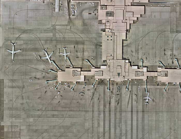
Government agencies are increasingly turning to high-precision aerial imagery to solve city-planning conundrums. Three recent case studies show how emergency 9-1-1 services gather data to provide updated maps to emergency services to get to the right locations as soon as possible; reveal how a city’s public works department streamlines data collection for more efficient infrastructure management; and how to give GIS professionals instant access to the most current information available — all in the cloud.
Photo: Nearmap
It’s said a picture is worth a thousand words. In the case of aerial imagery, where location data is packed into every pixel, a picture could save lives.
Emergency dispatch is just one type of government agency now relying on high-quality aerial imagery. With up-to-date georeferenced imagery of their own towns and counties, agencies are not only improving response to emergency calls, but also streamlining public works and enhancing city planning.
A company providing that imagery is Nearmap, which serves more than 8,200 organizations and businesses globally using small aircraft for image capture. The aerial mapping company provides high-quality imagery as a subscription service delivered through the cloud. Its photo maps are taken at least twice a year, with leaves both on and off the trees, to provide different views of locations in different seasons.
Nearmap’s patented camera system and software pipeline enables it to capture aerial photos, stitch them together into seamless digital maps, and publish the content online within days of capture. Above, Nike’s headquarters in Portland. (Photo: Nearmap)
Aircraft offers a huge advantage over unmanned aerial vehicle (UAV) or satellite imagery. Airplanes can cover much greater distances than UAVs, and pilots pay heed to the weather and fly below cloud layers to deliver the clearest visuals possible. Unlike space-based platforms, airplanes operate at lower altitudes, also increasing the resolution, and can fly on demand, unlike satellites that have set orbits dictating their periodicity for returning to a target area.
Nearmap’s powerful, patented technology allows it to deliver high-resolution aerial imagery as a service: orthographic (straight down) maps, multi-perspective panoramas and oblique aerial views — all at resolutions four times clearer than free satellite imagery.
Once photographed, the images are stitched together in the cloud in a matter of days, where they are available for viewing and analysis on desktop, tablet and mobile devices via a subscription service.
Nearmap’s proactive capture model is based on population — the larger the population, the more captures it takes per year. Nearmap images 88% of Australia’s population, 70% of the U.S. population, and 75% of the New Zealand population.
Nearmap captures many areas multiple times throughout the year; for many locations this gives customers a leaf-off and leaf-on view. Providing spring leaf-off captures allows customers a view of the ground that is typically obstructed by foliage the rest of the year.
The flight plans cover approximately 430 urban areas that are flown, captured and processed, and then served up via the MapBrowser in-browser tool, or supplied via application programming interface (API) for use in various design platforms. When a user subscribes to Nearmap, the capture is immediately available with any and all historical captures, without the need to pay for a dedicated flight.
“To capture imagery for a map, a plane has to crisscross over its own flightpath. Each sweep has to overlap the previous by approximately 70%,” explained William Tewelow, GPS World’s contributing editor for geointelligence. “Vertical (or nadir) is straight overhead. Oblique is everything else, but usually not exceeding 30% to either side because it distorts the structures and vertical features (parallax), makes mosaicking difficult, and shadows structures behind other structures.”
That said, oblique imagery is important for building 3D meshes for imagery point clouds, Tewelow said, as well as seeing various angles of a structure.
Following are examples of the creative — and surprising — ways government agencies are using Nearmap imagery to improve their services today, and prepare for future changes in their communities.
Better 9-1-1 address mapping
Shelby County is the largest county in Tennessee in both population (927,644) and geographic area (785 square miles). Memphis is the county seat, home to the county’s Emergency Communications District, for the operations of the local 9-1-1 emergency system.
The district provides Shelby County residents with an efficient emergency telephone number service using the latest technology, equipment and training for the various emergency service providers and dispatch centers.
For each dispatch center, the district provides county address location mapping. A secure database known as an ALI (Automatic Location Identification) contains the exact 9-1-1 address for any given associated phone numbers.
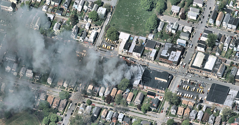
Albany, N.Y.: A house fire in progress. (Photo: Nearmap)
When a 9-1-1 call comes in, the database is queried by the Public Safety Answering Point to obtain the caller’s location. This data is then placed in the computer-aided dispatch software and 9-1-1 mapping software used by the district to help fire and rescue, emergency medical services and law enforcement gain instant access to updated maps containing GIS data needed to get to the right locations as soon as possible.
The 9-1-1 mapping system uses geodetic coordinates to plot wireless calls on the map. The system also reverse geocodes the coordinates to provide the 9-1-1 telecommunicator with a calculated civic address based on proximity of other features in the map, such as address points or streets.
Out-of-Date Imagery. For years, Shelby County’s aerial image process required a contracted flight to photograph the county areas. Because of the high cost of capturing those images, the county purchased images once every two years, after pooling resources from various county entities.
“We had gaps where we wouldn’t have updated imagery,” said Timothy Zimmer, the district’s GIS administrator. “While the images were high resolution, there were issues with mosaicking the separate images together, and since the imagery was taken every two years, many rural and unincorporated areas were out of date.”
With out-of-date images, the county had to develop alternate methods to locate addresses for the 9-1-1 systems.
Moving into the Cloud. In the summer of 2018, Zimmer began to work with Nearmap. With Nearmap, Zimmer and his team can access current imagery to geocode new addresses and developments as well as plot new roads into the 9-1-1 mapping systems (Figure 1).
For Zimmer, the biggest advantage is that Nearmap’s imagery integrates directly into Esri’s ArcMap, ArcPro and ArcGIS Online applications, so he can overlay GIS information directly over the high-resolution imagery.
“I really like how Nearmap is integrated into the GIS stack,” Zimmer said. “We’re able to stay on top of new developments, roads, and addresses. Being able to have Nearmap imagery integrated into our GIS systems helps us be much more accurate.”
The combined impact of data services, base maps, Nearmap imagery and third-party data are improving all aspects of public safety, including law enforcement, fire and emergency medical services.
Other Shelby County agencies also are using the district’s imagery and GIS data. “The county clerk and the utility company are using our address mapping data because Nearmap has helped enable us to be much more current,” Zimmer said.
Public works in a fast-growing city
Durham is one of the points in North Carolina’s high-tech Research Triangle and home to Duke University.
An economic and cultural renaissance is happening in the city. With a revitalization of its downtown district, the redevelopment and repurposing of former tobacco districts into tech hubs, and chic loft-style apartment complexes, Durham is rapidly growing beyond its most recently reported 250,000 population numbers.
Impervious Challenge. In early 2018, the city’s growth explosion prompted Edward Cherry, GIS administrator for the City of Durham Public Works Department, and his staff of 14 GIS professionals to seek ways to streamline their data collection.
The department manages all infrastructure data for the city, including mapping the impervious area. As defined by the U.S. Geological Survey, impervious surfaces include highways, streets, pavement, driveways and even house roofs — any surface that won’t absorb rainwater. Rather, the rain runs off into storm sewers and then into local creeks; localized flooding is often the result.
Durham Public Works manages half a billion square feet of impervious area. The city’s $16 million-a-year Stormwater Utility Fee income was a driver for Cherry’s team to explore satellite imagery options. Imagery from satellites, however, were infrequent and too low-resolution to meet their needs. The satellites captured images only once-a-year, and that might be on a cloudy or rainy day. Clouds cast shadows, and rain makes pavement appear newer than it is.
Nearmap’s aerial imagery, captured in Durham three times a year at a 2.8-inch ground sample distance (GSD), solved the problem (the GSD of each individual pixel in the imagery represents 2.8 inches on the ground. See Figure 2).
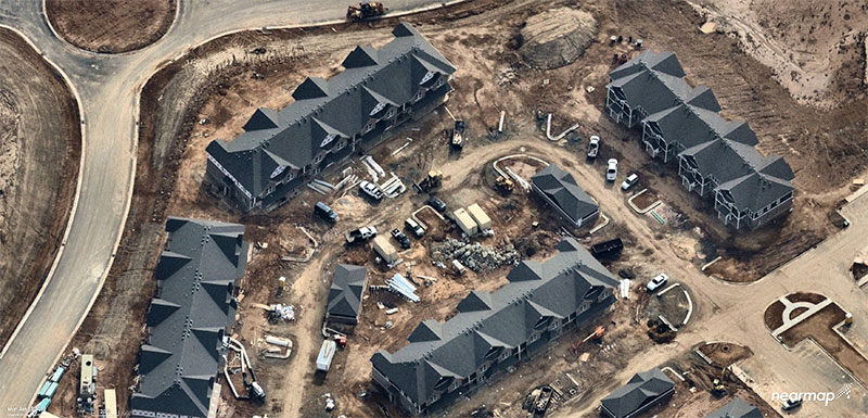
Figure 2: Rapid growth requires frequent imagery. Above is a new Durham neighborhood under construction. (Photo: Nearmap)
Dozens of projects in the Public Works Department — from road maintenance and pothole patching to water sampling and degradation — are using the improved imagery, which has saved the city money, reduced time spent in the field, and allowed crews to use real-time imagery when they are working in the field.
Monitoring Pavement Conditions. The City of Durham is responsible for maintaining most of its roads, and conducts a road-condition survey that samples different sites, evaluating the level of degradation.
Since 2014, Nearmap has regularly captured Durham streets at the same resolution and accuracy, and both the historical and current data are available to the department. With multiple high-quality image captures at high resolution, surveyors can see sections that have been recently paved. “We don’t need to send crews out to an area where a stretch has already been paved,” Cherry explained.
Road Repair Documentation. As in any city, the patching of potholes is an ongoing project for Durham’s public works department. With imagery, the city has been able to streamline the process.
Traditionally, the streets department sent out inspectors to spray paint and circle areas that required repairs. “Then we would produce maps and hard copies to direct [road repair contractors] ahead of time on a scheduled event,” Cherry said.
Now the city uses an application integrated with Nearmap imagery by which contractors can view the job on their smartphone or tablet while in the field. The surveyors can edit and draw the areas that need patching instead of physically going out and spray-painting them. “Then, in real time, the people doing the patching can see a very high-resolution image of where they need to do the work,” he said.
The pothole image captures are recorded, so the city knows where and how many potholes were patched. “We can see where work has been done when we are billed for it,” Cherry said. “We can visualize the work, which is an added bonus.”
Mapping Riparian Zones. With imagery previously taken only when the leaves had fallen (known as leaf-off), surveys of riparian zones in Durham proved limiting.
With imagery captured during both leaf-off and leaf-on seasons, riparian buffers around streams can be properly monitored for expansion. The buffers can be altered if there are issues with a stream’s path, such as sediment clogging the flow, repeated flooding or people intruding on a buffer.
Change Detection. High-resolution imagery has improved Durham’s billing process by producing web service maps that capture individual storylines. Stormwater billing customers, for instance, can visualize their properties with the impervious areas mapped out and tied to their billing records.
With up-to-date imagery providing data for change detection software, records also show when a customer has added a driveway or an extension to their house.
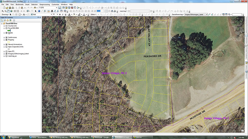
Figure 3: Aerial Imagery of an Apex neighborhood displayed in ArcGIS from Esri. (Image: Nearmap)
“Having access to imagery back to 2014, we’re able to go back in time during the thrust of development and monitor it forward,” Cherry said.
Nearmaps’ library of historical imagery allows for change detection algorithms to run in Esri’s ArcGIS imagery analysis software suite.
More efficient government
GIS data combined with aerial imagery is tailor-made for city planning and managing urban growth.
For instance, the population of Apex, N.C., has more than doubled since 2000. Situated near Raleigh and the state’s Research Triangle Park, Apex was rated number one in Money magazine’s 2015 “Best Places to Live,” which cited Apex’s charming downtown, highly rated schools and high-paying technology jobs.
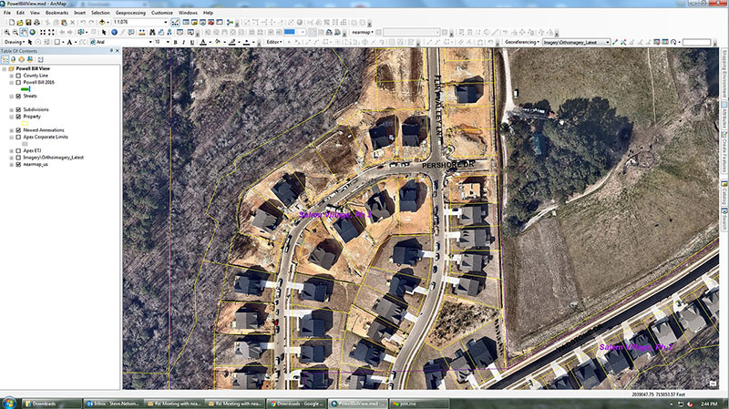
Figure 4: The post-construction image of the same neighborhood is much more accurate. (Image: Nearmap)
To manage the explosion in development, Apex’s GIS professionals needed instant access to current information. The old-school method required planners to drive the streets, inspect roadways, and roll out the measurement wheel. Now, the combination of Esri ArcGIS for mapping and Nearmap high-resolution aerial imagery allows them to visualize and measure within six inches of accuracy.
“Our ability to leverage our GIS operation improved dramatically with Nearmap. The flexibility of its cloud solution and ability to integrate with ArcGIS has redefined how we rapidly respond to staff and citizen requests,” said Steve Nelson, a GIS professional with Apex.
The use cases for these solutions are diverse. Law enforcement calls on GIS professionals from Apex to quickly provide current, clear, aerial photography for active or ongoing investigations. Planners focused on development are charged with meeting state regulatory reporting guidelines when it comes to building and maintaining roads. Environmentalists want to know if anyone is digging on protected land.
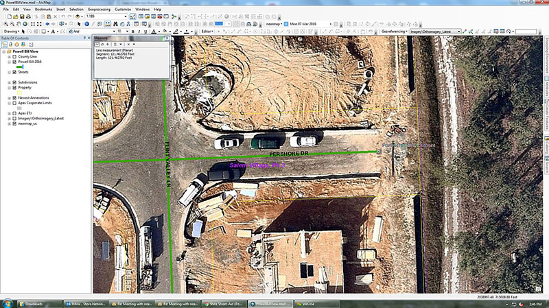
Figure 5: Measuring for reimbursement in Apex. (Image: Nearmap)
For the State Street-Aid Program, financial allocations are made to incorporated municipalities eligible under North Carolina law. State routes that pass through incorporated cities are maintained by the cities. Cities are responsible for paving new roads, but the state has the power and economic means to reimburse them.
To qualify for reimbursement for new roads developed and maintained, Apex needs to submit a report to state engineers for review. The report documents the distance for all newly paved roads.
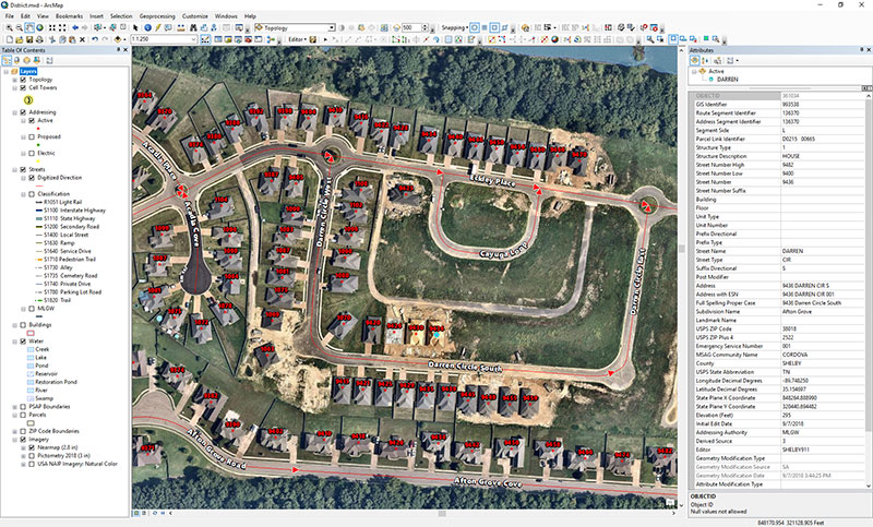
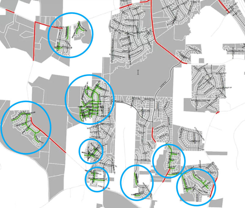
Before the new system was in place, GIS professionals had access to imagery from 2013, but the actual development took place after this. In (Figure 3), the 2013 imagery simply outlines the parcels and rights of way. It has no detail with respect to where the roads start and end, so a lot of field work was needed to take measurements, drive roads scattered across the county, and collect data.
Figure 6: Green lines indicate new streets in Apex in a single year (2013). (Image: Nearmap)
With the new system, workers have instant access from their desktop to the same location as it currently is. They can see exactly where the edge of the road starts and stops (Figures 4 and 5), which is different from the yellow-lined “right of way” depicted in Figure 3. While in the office, GIS professionals can measure distances precisely, creating an accurate representation of ground truth.
Figure 6 highlights a small portion of new roads built in Apex in one year. The green lines highlighted are scattered across the city. As Apex continues to grow and annex adjacent territory, the dynamic nature of the growth will be captured and uploaded to the cloud.
Unlocking Potential
As cities grow in complexity, mapping becomes integral to planning. With the advances aerial imagery provides, cities are starting to unlock the full potential of location data and visualizing a better future.
Aerial imagery business Nearmap has launched its new 3D product to streamline the way industries such as urban planning, architecture, construction, government and councils view and shape cities across Australia and the U.S.
The company is also previewing its groundbreaking artificial intelligence (AI) technology at its customer event Navig8.
Nearmap 3D allows customers to stream and export 3D imagery on demand at massive scale through its proprietary MapBrowser web application. Because the imagery is updated frequently, businesses can work with the most current information to make more informed decisions.
Nearmap’s new AI technology is turning millions of aerial images — captured over a decade and multiple times a year — into valuable datasets. The datasets can be used to more accurately and efficiently measure change and quantify attributes, such as solar panels, pools, roofs or construction sites.
Organizations ranging from small businesses to large companies and cities will be able to take advantage of AI-driven location intelligence.
“Product innovation is in our DNA. Everything we do has the customer at the core,” said Tony Agresta, executive vice president of product at Nearmap. “Our customers’ worlds are evolving every day. We need to keep innovating to continue to give our customers a competitive advantage through technology breakthroughs like the ones we are sharing today at Navig8.
“Nearmap 3D is the result of a significant investment in R&D, but also listening to our customers and what they need to transform the way they work,” Agresta said. “Accessing 3D imagery up to now has typically been an arduous, time-consuming and expensive process — but not anymore. This represents the single largest, most frequently updated footprint of 3D accessible through a browser. The ability to measure in 3D space, size up an area and then export Nearmap 3D for use in other platforms will transform the aerial imagery market.
“The AI technology that we’re working on will allow organizations to identify locations with specific attributes and in so doing, reduce site visits, generate more leads, and eliminate the time involved to inspect properties manually. Nearmap AI does the heavy lifting so you don’t have to,” Agresta said.
Composite aerial image of Perth, Australia. (Image: Nearmap)
Instant access to 3D through MapBrowser
Nearmap is making 3D imagery accessible to anyone, in the same way it has with 2-D. While Nearmap has offered 3D imagery since 2017, this new iteration of the technology allows users to instantly stream 3D content at massive scale via its MapBrowser web application.
The lightweight platform offers customers an immersive 3D experience, allowing them to visualize cities in 3D from any direction, measure distances, and immediately export a custom area in a variety of 3D formats at unprecedented speed — the download time is a matter of minutes for most requirements and only a few hours for very large footprints.
“It’s like switching from DVDs to streaming services,” said Tom Celinski, executive vice president of technology and engineering at Nearmap. “Our camera technologies have been capturing 3D since 2017, but now our secret sauce is bringing it onto MapBrowser, allowing users to easily and instantly stream this content with many export options. Now users can visualize, measure, define a custom area, export our 3D and use it in their workflows with other commercial platforms and tools. We’re helping 3D experts and novices alike access reality like never before, and this is an important next step in our Reality as a Service journey.”
Nearmap 3D comes with an extensive library, covering more than 400,000 square kilometers. It is updated once a year and covers major urban areas in Australia and the U.S.
“We live in a 3D world, we think in 3D, and so we have to ensure that our products give the closest representation of reality as possible,” Celinski said. “That means businesses that rely on visualizing 3D content, like architects, for example, can now access up-to-date 3D models instantly and export them in just minutes. In a tender process, for example, that can be the difference between winning a new project or not. The opportunities for Nearmap 3D are endless.”
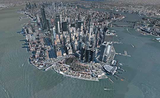
3D image of Manhattan. (Photo: Nearmap)
A living data set
Nearmap AI technology is the result of more than two years’ worth of research and development, and a team of close to 20 data scientists and machine learning engineers. The team, led by Dr. Michael Bewley, is using the petabytes of imagery that the business has captured over the past 10 years and turning it into a living dataset to accurately identify changes or quantify attributes from the Nearmap library of aerial imagery.
Nearmap has built highly accurate machine learning models and deployed them on a massive scale. The automated process, and the constantly learning engine, means that the AI technology can be applied to any new geography. Nearmap also applies the models to new surveys, generating fresh results with current imagery.
To date, Nearmap has performed analysis on over 1 million square kilometers of imagery across Australia and the U.S. (which constitutes about 80 million properties) and is performing more analysis every day. Nearmap is now inviting customers to take part in a beta program to experiment with various use cases.
“We don’t prescribe how our technologies or content can be used by our customers,” said Michael Bewley, director of AI systems at Nearmap. “Our solar customers could use the AI technology to easily identify where and when solar panels have been installed for maintenance jobs, to prospect new clients in an area where solar energy’s popularity is on the rise; or a government entity that previously had the arduous task of tracking swimming pools or construction in their jurisdictions will be able to do it automatically.”
“But this is the tip of the iceberg — we’re just getting started. This technology is going to profoundly change the way that cities are built,” Bewley said. “Our plans include delivering AI results in many forms, much the same way we deliver our imagery today.”
Both technologies will be presented at Nearmap’s flagship event, Navig8, in Perth on June 6, Melbourne on June 11 and Sydney on June 13.
We’ve all been there before: static on our wireless call or, worse, the call drops at the most inopportune time. Like instant response when we surf the web, consumers have come to expect clear, consistent call connections when using mobile. With too much of a bad thing, the churn risk soars to untenable heights.
5G, shorthand for Fifth-Generation Wireless Systems, holds the promise of transforming our daily lives. Using massive bandwidth, extremely low latency and high speeds, almost everything that requires sending and receiving data gets a boost. Unique radio frequencies transmitted with precise directions improve on the older 4G approach by taking advantage of higher frequencies. The signals take less time to transfer from one device to another, dramatically reducing wait times.
How does this help business and the consumer? Video conferencing is better, call connections are clearer, and smart homes get their Ph.D. How does this become reality?
Rather than using satellite-based towers, 5G depends on shorter signals using antennas and other transmission devices installed closer to the ground, on the tops of buildings and existing utility poles. Herein lies the rub. Ground features such as trees or tall structures can interfere with transmission. On top of this, there’s the need to plan for change. Vegetation grows over time, new construction takes place, and the cycle of interference continues. Imagine trying to plan a 5G network in an urban environment replete with hundreds or thousands of tall buildings. How would a telecom decide where to place the hardware and optimize the network?
The answer rests in aerial imagery, also known as aerial mapping. Rather than relying on satellite imagery that’s less clear and prone to atmospheric conditions, high-resolution camera systems mounted inside planes are photographing the world — all in 3D. Within predefined coverage areas, every point on and above the ground is being photographed and transformed into a variety of 3D models. For the telecom industry, planners can predict zones of interference and place hardware accordingly. They can better service their customers and quickly adapt to changing conditions in support of maintaining the network.
One type of output from these advanced camera systems is called a digital surface model, providing detailed elevation profiles of ground features, building, bridges, you name it. Also knows as DSM, the elevation detail contained within the imagery facilitates analysis to optimize the placement of 5G antennas and transmission devices.
When combined with other forms of imagery that allow users to clearly visualize every aspect of the landscape in photorealistic, immersive 3D, this enables telecoms to quickly model all the transmission permutations.
These high-tech companies use machine learning to identify clear signal areas and sections of the landscape where a tree, for example, may degrade the 5G radio frequency. Armed with such intelligence, strategic placement of hardware unlocks the optimized network — all without having to leave the office to collect data from the field.
The race is on to roll out 5G. Fortunately, advances in aerial photography have been combined with machine learning and artificial intelligence (AI) to speed up network planning and change modification. With tens of thousands of access points needed for large cities, advanced uses of aerial imagery and data science provide the answer for fast 5G deployment.
Less than a decade ago, mobile mapping systems were being designed and sold using computer systems that rivaled most desktop computers. Mobile mapping vehicles had to be custom-fit for large displays and computer systems, usually with large, expensive, bulky redundant arrays of inexpensive disk (RAID) storage systems that would consume the back of a van or, at the very least, the back seat of a car. Wiring for these systems completely entangled the vehicle, making it a dedicated part of the mapping system. Many of these systems are still being used today, as their utility is only lost on space consumed but not on usability or productiveness.
In 2019 we face the ever-increasing demand for smaller size with greater performance, especially in the instance of UAVs, where size, weight and power consumption are precious commodities.
Wires? Nobody wants or expects to see any wires or cabling running between devices, with the possible exception of power. A desktop computer, laptop or RAID system is no longer a consideration. Storage is replaced by high-speed, high-capacity media such as Compact Flash, Flash memory cards, and solid-state drives.
And all of those wires? They are replaced by Wi-Fi or Bluetooth working directly between the onboard microprocessor (at most the size of a deck of cards) and what else? Your cell phone. Maybe a tablet.
The inertial navigation system inside these UAVs, the central nervous system of a mobile mapping set-up, can no longer afford to weigh several kilograms. It must weigh under 1 kilogram, with less than 500 grams preferred. The accompanying antennas must also shrink.
At the same time, cost must drop while performance must be maintained or improved. More users will adopt the technology, and they will no longer be experts. Reliability and durability will be of utmost importance.
Nearmap high-resolution aerial image of Durham, North Carolina, photographed Jan. 15. (Photo: Nearmap)
Location content provider Nearmap has partnered with the city of Durham, North Carolina, to help it manage infrastructure projects.
The city’s Public Works Department uses Nearmap’s high-resolution imagery to aid in managing all infrastructure data for the city, including the city’s $16 million a year Stormwater Utility Fund.
“Having access to imagery back to 2014, we’re able to go back in time during the thrust of development and monitor it forward,” said Edward Cherry, Durham’s GIS administrator. “With Nearmap, we’ve been able to update development processes and policies to support the revitalization of the downtown district as well as rapid city growth.”
After using satellite imagery systems with low resolution and infrequent captures, Cherry and his staff of 14 GIS professionals determined the city needed superior mapping imagery.
Captured every six months at a 2.8-inch ground sample distance, Nearmap supplies Durham with clear images that are up-to-date and accessible through web-based cloud servers, the company said.
The result is better monitoring of pavement conditions; time savings and documentation of road repairs; more detailed maps of city riparian zones; and accurate and detailed customer billing.
Fugro has completed a landmark data acquisition campaign over the Turks and Caicos Islands, marking the first commercial success of its new Rapid Airborne Multibeam Mapping System (RAMMS).
Working under contract to the United Kingdom Hydrographic Office (UKHO), the company acquired more than 7,400 square kilometers of integrated, high-resolution bathymetric, topographic and image data. The resulting deliverables will support updated nautical charts and coastal zone management activities in the region.
Launched in August 2018, RAMMS is a highly efficient, next-generation airborne bathymetric mapping system that uses multibeam laser technology to deliver depth penetration and point densities, the company said. The compact sensor is deployed from small aircraft and can be integrated with other remote sensing technologies for simultaneous collection of multiple complementary datasets.
For the Turks and Caicos project, this approach made it possible to acquire near-shore (bathymetry) and coastal (topography and imagery) data in a single deployment, producing a cost-effective solution and advancing Fugro’s sustainability goals by significantly reducing fuel consumption.
“After years of development, it’s extremely gratifying to operate RAMMS commercially and to demonstrate to clients the value that this cutting-edge technology can bring,” said Mark MacDonald, Fugro Americas Marine Division hydrographic service line director.
He pointed to the massive Turks and Caicos project as an example. “The system’s multibeam lidar capability allowed us to achieve point densities that otherwise would have required vessel-based surveys. With RAMMS, we were able to avoid that additional time and expense, and significantly reduce health and safety exposure.”
Fugro is working on three additional RAMMS projects in the Americas region, one for UKHO in Belize, and two for the Canadian Hydrographic Society, in Quebec and Atlantic Canada. These projects are similar in scope to that of the Turks and Caicos project, combining bathymetry, topography and imagery for maximum value to clients, serving both navigation and coastal applications.
Based on steady interest in RAMMS, Fugro and technology partner Areté Associates are building an additional system to meet anticipated contracting volumes in 2019.
Fugro is also finalizing a cloud-processing capability, which will further improve client delivery by streamlining data review and approvals, and ultimately making data available for download-on-demand.
Additionally, Fugro aims to operate the unmanned aerial vehicle-proven system autonomously in 2019, providing further operational efficiency gains and increasing access to remote project areas.


 Nick Spittlemeister
 Dave Cassin
 Kevin Kleinjan