CityMapper is a hybrid airborne sensor combining vertical and oblique imagery with 3D laser scanning designed for 3D city modeling and urban mapping.
Using the CityMapper, Bluesky was able to capture parts of London, Manchester and Birmingham as well as Brighton, Bristol, Cambridge, Norwich, Nottingham and Oxford. Bluesky intends to increase its coverage by capturing additional towns and cities across the U.K. and Ireland in 2019.
St. Paul’s Cathedral in London captured in lidar point-cloud data. (Image: Bluesky)
According to Bluesky, this is the first time the technology has been used commercially in the UK to this level. The captured city data is available from Bluesky and Leica Geosystems, part of Hexagon, in its constituent components of vertical orthorectified aerial imagery, oblique photographs and lidar point cloud data. Plans are in place to also include the imagery in the HxGN Content Program.
The combination of multiple survey-grade cameras and lidar enables the simultaneous capture of data for the automatic creation of highly accurate and detailed citywide 3D models, with one sensor, according to Bluesky.
Previous 3D models have either been prohibitively expensive for use across larger areas or of insufficient detail or accuracy. The CityMapper sensor enabled efficient, cost-effective capture of highly detailed and accurate data, and could make possible widespread use of 3D models possible.
The CityMapper sensor is designed for 3D city modeling and urban mapping. (Photo: Leica Geosystems)
CityMapper includes a traditional vertical camera as well as survey-grade oblique cameras. The sensor also includes high-performance lidar technology to accurately collect elevation data even into the shadows, which are common in urban environments and make photo-based data collection difficult.
The CityMapper sensor also collects color infrared data, which can be used to aid greenspace mapping and vegetation studies.
Applications of the new Bluesky 3D models are expected to include urban planning, line-of-sight analysis, new development visualizations and environmental modeling, as well as potentially 3D fly throughs and virtual reality experiences. Early adopters of the data include architects, planning consultants and other map publishers.
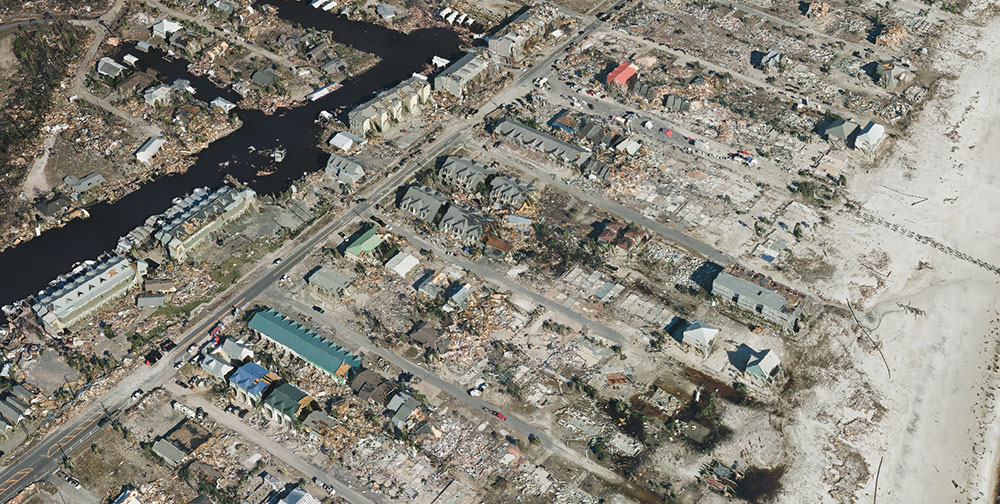
Correlator3D was used to process large format imagery collected by Midwest over Mexico Beach, Florida. (Image: SimActive)
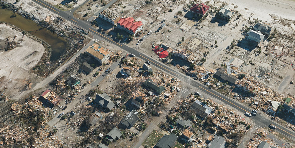
SimActive Inc., developer of photogrammetry software Correlator3D, has partnered with Midwest Aerial to perform damage assessments of Hurricane Michael.
Correlator3D was used to process large format imagery collected by Midwest over Mexico Beach, Florida. The joint effort resulted in highly precise geospatial data, including a digital surface model (DSM), an orthomosaic and a 3D model, the company said.
“This is a terrible disaster for the people affected and we hope they can benefit from geospatial technologies available,” said Philippe Simard, president of SimActive.
The gallery below shows samples of the imagery collected.
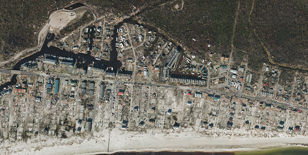
SimActive partnered with Midwest Aerial to perform damage assessment of Hurricane Michael. (Photo: SimActive)
Correlator3D was used to process large format imagery collected by Midwest over Mexico Beach, Florida. (Image: SimActive)
Aerial imagery of the devastation from Hurricane Michael in Mexico Beach, Florida. (Image: SimActive)
SimActive’s Correlator3D is a patented end-to-end photogrammetry solution for the generation of high-quality geospatial data from satellite and aerial imagery, including UAVs. Correlator3D performs aerial triangulation and produces dense DSM, digital terrain models, point clouds, orthomosaics, 3D models and vectorized 3D features.
Powered by GPU technology and multi-core CPUs, Correlator3D ensures high processing speed to support rapid production of large datasets, the company added.
Midwest Aerial Photography focuses on acquiring high-quality aerial imagery and companion data in support of photogrammetric mapping projects across the United States and Canada. Midwest partners and clients include federal, state and local government agencies, as well as photogrammetric firms and architectural and engineering companies.
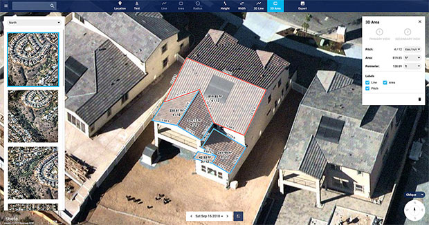
Nearmap high-resolution aerial image showcasing new toolset in MapBrowser, captured Sept. 15, 2018. (Image: Nearmap)
Nearmap has introduced a complete measurement toolset in MapBrowser for the solar, roofing and other rooftop industries.
The new tools allow users to measure roof-pitch, height, width and area, enabling roofers and solar installers to confidently measure rooftops and structures from high-resolution oblique aerial images, the company said.
The new MapBrowser helps customers significantly reduce onsite visits during the quoting and planning stages of projects and complements their remote roof/site inspection workflows, giving many small businesses the power of expensive systems that only large companies use.
“Gone are the days of climbing on roofs to take measurements,” said Tony Agresta, executive vice president of product at Nearmap. “Delivered to the cloud within days of capture, our aerial imagery allows roofers, solar companies and other small businesses to carry out assessments from the comfort of their office. Once the domain of large companies, the new features provide businesses of all shapes and sizes with the tools they need to save time, plan and estimate more accurately at a fraction of the price.”
Using Nearmap’s new tools, roofers and solar companies will be able to:
Prospect more efficiently by viewing and expanding opportunities through aerial maps instead of other, more traditional ways.
Process leads more quickly by qualifying prospects prior to visiting a potential job.
Reduce costs associated with the qualification and proposal stages.
Create better proposals using up-to-date, high-resolution photos, giving companies a better chance at winning a client’s business.
Close more sales with the most accurate and competitive quotes.
Increase revenue without adding systems or headcount.
Businesses in construction, home building, painting, insurance and other industries can also benefit from these new tools to accurately measure areas on properties in three dimensions. Nearmap’s aerial imagery can help users to show context for work being done, and the imagery can be annotated with notes, drawings and measurements that provide details of the plan.
Nearmap Oblique imagery can be accessed through a standard web browser using Nearmap’s intuitive MapBrowser application. In addition, Nearmap Oblique photos are published at sub-7.5cm ground sampling distance (GSD) — better than satellite imagery — which allows users to see great detail, Nearmap said.
Location content provider Nearmap has partnered with the City of Durham, North Carolina, Public Works Department to upgrade its imagery on numerous projects.
Using real-time imagery from Nearmap in the field, the department streamlines data collection and saves time and money.
The department manages all infrastructure data for the city, including mapping the impervious area (structures that resist water infiltration) for the city’s $16 million a year Stormwater Utility Fee fund. “That is half a billion square feet of impervious area that we manage through digitization and review daily,” said Edward Cherry, city GIS administrator.
After using several satellite imagery systems with low resolution and infrequent captures, Cherry and his 14-member GIS staff determined the city needed far superior quality in their mapping imagery to accommodate the city’s explosive growth.
Captured every six months at a 2.8-inch ground sample distance, Nearmap now supplies Durham with up-to-date images accessible through web-based cloud servers.
With Nearmap, the Durham Public Works Department has achieved better monitoring of pavement conditions; time savings and documentation of road repairs; more detailed maps of city riparian zones; and accurate and detailed customer billing.
“With Nearmap, we’ve been able to update development processes and policies to support the revitalization of the downtown district as well as rapid city growth,” Cherry said.
Aerial imagery specialist Spookfish has expanded its capture program into New South Wales (NSW), now covering the NSW coast and Sydney’s entire metropolitan area. Spookfish’s coverage in NSW now spans from Newcastle to Kiama and from Lithgow to Manly.
The expansion into NSW marks the next stage of a nationwide rollout for Spookfish. In the past 12 months, the company has expanded coverage into the South Australian, Victorian, Australian Capital Territory and now NSW markets, in addition to its Western Australian coverage.
The expansion of coverage will give businesses and government agencies across Sydney and regional NSW the opportunity to access high-resolution aerial imagery and save thousands of dollars by reducing the time spent on site.
Spookfish now covers the entire Sydney metropolitan area, home to 71% of the NSW population. The city’s growth presents development opportunities for businesses, all of which need to fit within city planning regulations. High-resolution aerial imagery will play an important role in the planning stages.
Spookfish also captures regional cities and towns, including Albury and Wagga Wagga, at the same consistent specification as capital cities.
With the addition of Perth, Melbourne and Adelaide’s entire metropolitan areas, Spookfish offers users access to more than 55,000 square kilometers of high-resolution imagery across Australia. The platform provides customers a clear view on any device with no data caps to give users access to unlimited high-resolution aerial imagery without the risk of unexpected costs.
“Sydney has the greatest population density in Australia, and continues to grow with new projects commissioned to meet this growing population,” said Jason Waller, Spookfish CEO. “We are very pleased to be able to offer businesses access to high resolution imagery of this unique city, to help drive effective and precise planning of developments and urban areas.
“Every day our platform is being discovered by many Australian businesses, helping them save time and money by providing precise aerial imagery with the timeliness and convenience of cloud delivery. We offer our customers a service like no other, where they can access extremely high resolution images at an affordable price across very large areas, with no data caps.”
Spookfish utilizes a fleet of specialized planes to capture imagery for its platform. With regular updates in capital cities across Australia, customers have an up-to-date and evolving view of their world.
The three-year program helps emerging business partners bring new and innovative products to Esri customers.
The initial partnership between Hangar and Esri will enable ArcGIS customers to request and receive autonomous, precision-captured drone data on demand from within ArcGIS, enabling industries to gain real-time awareness and insight about locations and features.
The GIS community has grown accustomed to ambiguous and infrequent imagery. While emerging robotic enablers like drones provide a high-resolution, low-cost alternative to satellite and manned aircraft imagery, there hasn’t been a feasible way for GIS professionals to repeatedly gather precision location insight at scale, from potentially thousands of features within Esri maps, Hangar said in a statement.
Hangar not only makes aerial data possible at this scale, but also available on request from within ArcGIS. Using a system of systems, Hangar streamlines and automates the 4D data supply chain, enabling task-and-receive reality capture. In the near future, ArcGIS users will be able to request aerial insights at any feature, and have imagery delivered back in 24 to 48 hours or less.
“The pain we see in the GIS community is an inability to quickly and efficiently pair 2D data with the 3D reality,” said Jeff DeCoux, CEO and founder of Hangar. “We’re excited to work with Esri to deliver on-demand, precision 4D insight to ArcGIS users. Hangar will enable businesses to take full advantage of robotics as instruments of data collection, and provide the industry much needed repeatability and scale.”
ArcGIS Online users will have the capability to request and receive aerial imagery at variable frequencies or volumes. Requests can be made manually, on an as-needed basis, or automatically, based on contextual triggers or volume requirements. Data is autonomously captured, automatically processed, then delivered back to the customer via a high-speed delivery engine.
The digital missions behind requests are saved indefinitely, and can be performed repetitively with absolute precision and accuracy, preserving data integrity over time. ArcGIS users will be able to view captures within 24 to 48 hours from the initial request, across a variety of data types.
“Hangar empowers Esri users to explore any of the thousands of features within ArcGIS maps, observing ground truth at each pin in incredible detail, today and over time,” said Francis Kelly, Esri, global partner programs manager. “Hangar adds valuable data validity and scalability to the budding drone industry. We’re excited to work with them to give Esri users the ability to analyze and consume physical world content in a new and meaningful way.”
As big-data levels of precision spatial data are collected over time, Hangar will work with Esri to intelligently apply change detection and pattern recognition to enable a new era GIS that includes artificial intelligence and machine learning.
Hangar will be attending the Esri User Conference, July 9-13 in San Diego, at booth Z19 to demonstrate its technology and showcase the partnership with Esri.
According to Phase One Industrial, the iXM 100MP is a high-productivity metric camera with a range of high-resolution lenses. Photo by Allison Barwacz
Phase One Industrial has launched the iXM series, an aerial camera platform driven by its fast medium-format imaging sensor.
Engineered for UAV-imaging missions, the iXM 100MP is a high-productivity metric camera with a range of high-resolution lenses. It is ready for integration with various UAV platforms, including Phase One’s DJI Matrice 600 Pro solution.
The iXM 100MP metric camera incorporates the first medium-format sensor with backside-illumination technology, enabling high light sensitivity and extended dynamic range. Fast, highly responsive, robust and weatherproof (IP53 compliant), the iXM 100MP delivers superior quality aerial imaging and flexible operation to satisfy diverse mapping, surveying and inspection applications, the company said.
In addition, Phase One announced four new specially developed RSM lenses — with focal lengths ranging from 35mm to 150mm — to seamlessly fit the new sensor’s 3.76 μm pixel size and 33 x 44 mm frame size, ensuring image sharpness across the entire FOV. The lenses are available with either fixed-focus or motorized-focus functionality.
The fixed-focus 35mm and 80mm lenses provide superior image radiometric quality, high ground resolution and large coverage, suitable for surveying applications.
The motorized-focus 80mm and 150mm lenses are designed for a wide range of inspection applications, including electricity poles, wind turbines, bridges, and other private-sector or government structures.
Motorized-focused lenses, having no external moving parts, enable a number of new uses for inspection applications where the focusing distance can be predefined based on flight planning, or by the operator, using a wireless remote control. With the motorized lens, the camera captures sharp and highly detailed images of multi-distance or 3D objects.
The cameras’ RSM lenses incorporate a new leaf-shutter technology, which supports 3 fps capture — with a speed of 1/2500 sec — while guaranteeing 500,000 actuations. The lenses are thermally stable to ensure consistent focus over a wide range of temperatures and flight altitudes.
With optics designed to exploit the full benefits of the new sensor technology, the lenses provide with greater productivity, flexibility and reliability, offering superb image quality.
The new iXM platform adds XQD high-speed storage technology to handle the sensor’s extremely fast frame rate. Also on all cameras, HDMI output from actual exposure provides UAV operators simple and outage-free feedback of actual view, exposures, and camera status in overlays.
In addition, the new platform includes USB-C and 10G Ethernet for versatility of connectivity to large UAVs and aircraft.
“Working with our UAV partners, we see a fast-growing market driven by great potential for time and cost savings over traditional inspection and surveying methods,” said Dov Kalinski, General Manager of Phase One Industrial. “With its new technology, design, and capabilities, the iXM 100MP promises to help start a new era in inspection missions with UAVs. Phase One Industrial continues to push technical boundaries to equip drones and larger UAVs with superior imaging technology — engineering advanced systems, cameras, and software — to help achieve that potential.”
The iXM 100MP and iXM 50MP metric cameras are available for advance order from Phase One Industrial partners worldwide with delivery in June 2018.
An oblique image of downtown Chicago, captured in June 2017, with measurements. (Image: Nearmap)
Guest column by Sanchit Agarwal Vice President, Field Operations, Nearmap
With high-resolution imagery comes the ability to model reality, creating real-life visualizations for engineers, planners, construction teams and many others.
A quantum leap in computing capacity has allowed us to model and analyze the real world — all from our desktop and mobile devices. In days past, maps were purely for visualization and direction.
Today, they have graduated to full-blown analytics platforms empowering users to make decisions faster than ever before.
Why?
They closely represent truth on the ground — truth created from high-resolution aerial imagery captured at heights of up to 18,000 feet. Camera systems mounted in the bellies of planes can efficiently map the real world in incredible high detail. These aerial photographs are updated continuously.
In years past, access to aerial mapping content and services was reserved for more significant players.
Today, with easy access to scalable high-definition mapping content, anyone can utilize the power of maps in applications that extend far beyond directions and navigation.
There are two essential attributes of aerial maps driving this transformation — image resolution and model density. Today, most users are applying low-resolution satellite images that lack the detail needed for accurate decisions. But, as resolution increases, the imagery becomes more detailed; the visualizations, more vivid.
Ground features have gone from fuzzy satellite photos to clearly identifiable homes, buildings, roads, lakes and more — all captured using powerful cameras that have found the perfect pixel. With high-resolution comes added benefit.
Aerial image of the Aria Resort in Las Vegas captured in May 2017. (Image: Nearmap)
Users can manipulate the imagery — zoom closer and closer without losing the details. Computers can classify the features, distinguishing skylights from solar panels, walking paths from sidewalks, and pools from ponds.
Rich imagery is yielding richer data used to instantly query massive databases and return results that answer complex questions for businesses and government.
With high-resolution imagery comes the ability to model reality, creating real-life visualizations for engineers, planners, construction teams and others.
These models of landscapes, cities and neighborhoods are portrayed inside design tools and mapping systems, saving the analyst countless days of traveling to the site only to be surprised that the outdated low-resolution imagery does not depict what’s actually on the ground.
Imagery can vary greatly in resolution. Pixel resolution refers to the actual distance on the ground that each pixel represents in the orthophotography — the vertical image. For example, one-foot pixel resolution means that each pixel in the image covers one foot on the ground.
Common resolutions include three-inch, six-inch, one-foot and one-meter. The higher the imagery resolution (for instance, three inches per pixel), the greater the visible detail within the photograph. Clearly, a three-inch resolution is much better than a one-foot resolution.
Most mapping content currently consumed is two-dimensional and generated from low to mid-resolution nadir imagery. In other words, you see the land as if you were staring straight down at it, not height-of-ground features and certainly not change over time.
While that was adequate for some users, others reached for higher resolution and, while they were at it, decided they needed a third and fourth dimension — namely, height and time. These new perspectives provide more analytical options, more insights and a variety of new use cases that show change over time, height and multi-perspectives of the same property or landscape.
With the democratization of mapping products and services and the general trend toward consumption of multi-dimensional experiences, there is an implicit need to increase resolution, detail, dimensions and perspectives in mapping content and services as well.
The Rancho Mirage community of California, captured in February 2017. (Image: Nearmap)
Traditionally, satellite imagery has been used to monitor large areas of the earth at scale remotely. The resolution of the satellite imagery has graduated from multiple meters to feet with the advent of advanced mapping satellites.
The challenge here is the resolution. Low-resolution satellite imagery, although scalable, is good for macro-analysis of cities and neighborhoods but is not detailed enough for accurate measurements and micro-analysis at the level of each individual property.
On the other end of the spectrum come drone mapping solutions that offer the promise of delivering incredibly high-resolution datasets (sub-centimeter resolution) but fails to provide the scalability and repeatability.
Let’s get specific. Why does resolution matter?
You cannot measure what you cannot see. The resolution of imagery provides a more detailed, zoomed in and richer view of the real world, thereby enabling desktop based reconnaissance, inspection, analysis and measurement of features that are not traditionally visible in satellite imagery.
Higher resolution means high fidelity and dependable measurements. With the added details and definition of features that high-resolution offers comes the much-needed advantage of clearly and legibly identifying feature boundaries and hence measuring the feature with high precision and accuracy.
Higher resolution map content means fewer site visits. Rather than travel onsite to inspect and measure, many organizations are now relying on high-resolution imagery and, in the process, not having to waste resources sending team members on site.
High resolution means more detailed documentation of reality. Gamers have experienced reality-like landscapes for quite some time. Now, 3D and 4D mapping content allows users to immerse themselves in the landscape, navigate through street views, and fly like a bird to inspect rooftops with ease.
High resolution and refreshed content means more accurate change analysis. Identifying how locations have changed over time through multiple captures that embody leaf-off and leaf-on imagery allow users to not only visualize detail but also notice progress, changes in construction, degradation of property features, growth in vegetation and more.
High-resolution content means more automated workflows. High-resolution content allows for better feature definition models resulting in higher success rates in interpreting and analyzing the reality algorithmically. Higher success rates of automated algorithms results in efficient exploitation of datasets to solve real world problems.
Machine learning thrives on high-resolution content. There’s no shortage of news on the use of machine learning and artificial intelligence in data science. With the advent of high-resolution maps, machine learning is now able to differentiate skylights from solar panels, decks from patios and pavement from pavers. In turn, the ground features identified are being stored in databases for lightning fast queries to complex problems.
The higher the resolution, the higher your confidence will be.
Australian geospatial startup Spookfish has won a major Asia Pacific industry award for exporting imaging technology to the North American market.
Spookfish has partnered with U.S.-based EagleView Technology Corporation, a North America provider of aerial imagery, and the two companies have collaborated to develop new technologies to meet the demands of the North American market.
In mid-2017, EagleView placed its first large order for multiple Spookfish platforms following an extensive flight-test program. Spookfish is now building the platform in significant volumes to meet EagleView’s demands.
Meanwhile, rollout of the Spookfish imaging technology for Australian customers is underway. Perth-based Spookfish offers high-resolution imagery of Perth, Melbourne and Adelaide online, with Sydney and Brisbane in the works.
Spookfish’s technology enables rapid imaging of vast areas in high resolution from a multitude of angles at a fraction of the cost of contemporary systems, the company claims. Spookfish aims to use these capabilities to make it easy for organizations of all sizes to gain access to premium imagery content and pervasive 3D models allowing concise, accurate and cost effective decision-making.
The Asia Pacific Spatial Excellence Awards (APSEA) showcase excellence within the spatial industry. Presented at Locate & GeoSmart Asia Conference in Adelaide, Australia, the APSEA award recognizes Spookfish’s success in innovating, commercializing and exporting its imagery capture and processing technology. Spookfish took home the APSEA Export Award after competition from companies around the Asia Pacific region.
“This is an exciting achievement for Spookfish and the beginning of a substantial export opportunity for Australia,” said Spookfish CEO Jason Waller. “The award is a testament to the entire Spookfish team and their ability to research, innovate and successfully bring new technology into operation.
“Spookfish has begun delivering multiple systems to our strategic partner, EagleView Technologies, with the export program generating significant revenue from capture systems and expected future royalty payments.
“More importantly, the partnership with EagleView delivers extensive benefits to our Australian customers because as our world-leading technology continues to develop, it immediately becomes available in the domestic market.”
SenseFly is partnering with Trimble to optimize the drone mapping workflow for geospatial professionals.
The new integration is designed to ensure a smooth end-to-end mapping drone workflow. senseFly operators can now, within the recently launched eMotion 3.5 software, transform a senseFly S.O.D.A. camera’s georeferenced imagery into an automatically collated project (in .jxl format).
This enables the one-click import of drone imagery into the Trimble Business Center Aerial Photogrammetry module without the need for manual project creation and organization of images.
The senseFly-to-Trimble mapping workflow includes:
planning and monitoring a senseFly S.O.D.A.-based drone flight (in eMotion 3.5)
downloading the drone’s images for one-click georeferencing in eMotion 3.5 (Flight Data Manager)
clicking to create a .jxl format mapping project
opening a project within the Trimble Business Center Aerial Photogrammetry module
processing the drone’s imagery to generate orthophotos, contour maps, point clouds, digital surface models (DSMs) and feature maps
analyzing and acting upon the data.
Screenshot: Trimble
“Making work easier and more efficient for geospatial professionals is the goal that drives every solution we develop,” said Jean-Christophe Zufferey, senseFly co-founder and CEO. “Therefore, we are excited to collaborate with Trimble on more tightly integrating our solutions, since enhancements such as this new eMotion-to-Trimble Business Center workflow do exactly that, ensuring that the transition from data collection to acting upon this data is as seamless as possible.”
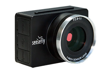
The senseFly S.O.D.A. is built for professional drone photogrammetry work. The 1-inch, 20-megapixel RGB camera captures sharp aerial images across a range of light conditions, allowing senseFly fixed-wing drone operators to produce detailed, vivid orthomosaics and ultra-accurate 3D digital surface models.
senseFly S.O.D.A. is compatible with most senseFly fixed-wing mapping drones, including the large-coverage eBee Plus.
Trimble Business Center allows surveyors and other geospatial professionals to combine aerial photography with data collected from GNSS receivers, total stations, 3D laser scanners and more, for a complete field-to-finish workflow. By combining imagery from unmanned aerial systems with ground-based survey data, users can visualize their project from both aerial and terrestrial perspectives, measure points within the images and create 3D models of the infrastructure and terrain.
Wingtra has officially launched the WingtraOne PPK high-precision mapping drone. Wingtra said its drone, which features vertical take-off and landing, is designed to set a new benchmark for large-scale surveying and mapping applications.
WingtraOne PPK offers large area coverage, ultra-high accuracy and brilliant image resolution. It features an advanced PPK module and high-quality cameras like the 42-megapixel full-frame camera Sony RX1RII, it is now possible to reach down to 1-centimeter absolute accuracy in aerial mapping.
To prove this accuracy claim, the Wingtra team performed test flights in a gravel quarry. The process was documented and is now explained in a white paper on the company website.
Conventional drone mapping on centimeter accuracy requires ground control points (GCPs) to correct the final map. Besides requiring additional surveying equipment and being extremely time consuming, setting up GCPs might be downright risky or just not possible in the area of interest.
More advanced solutions achieve similar levels of accuracy by using GPS correction technology for the georeferencing of the aerial imagery: namely RTK (real-time kinematics) or PPK (post processed kinematics).
RTK requires real-time base station connectivity and corrects GPS signals during the flight, while PPK corrects them after the flight and therefore offers greater robustness and consistency.
Moreover, PPK is independent from base stations or base station networks. It is highly reliable, accurate and time saving to use, Wingtra said. Neither special flight preparations nor intensive post-processing steps are required to achieve down to 1-cm accurate aerial maps.
Providing high-speed internet access to businesses and residences is a highly active and expanding field. It closely involves geographic information systems (GIS) to efficiently achieve fiber to the home (FTTH) or fiber to the premises (FTTP), the installation and use of optical fiber from a central point directly to individual buildings such as residences, apartment buildings and businesses for high-speed internet access.
A free webinar on Jan. 18 will cover — among several other related topics — the integration of high-accuracy aerial imagery into this process. David K. Nelson, GISP, a GIS manager in telecommunications for Black & Veatch, will make the presentation. It will be complemented by a talk on how to “Plan Virtually, Manage Efficiently with High-Definition (HD) Aerial Maps” by imagery provider Nearmap, and one on use of HD aerial imagery for city storm-water management.
David Nelson, GIS manager, telecom, for Black & Veatch
Nelson is responsible for developing GIS solutions for projects with the Black & Veatch’s telecommunications division. With over 13 years of experience in public and private sectors, Nelson is a visionary for adopting and enabling geospatial technologies and location content that drive operational efficiency. His presentation will cover such topics as GIS-centric approach for all projects; file-based vs. data-based transition; geospatial archives of all data; and integration with other technology platforms.
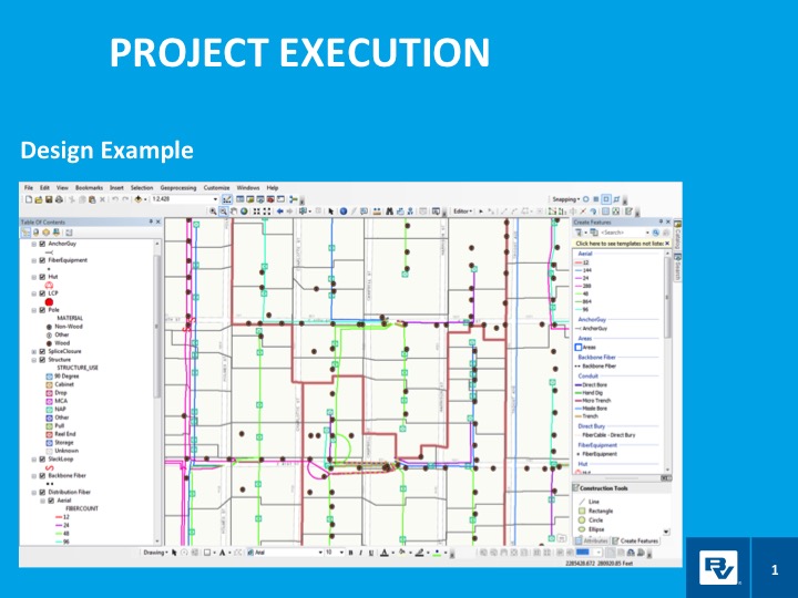
In a case study, he will take webinar attendees through a FTTH project design and execution example.
Black & Veatch is an engineering, consulting and construction company with more than 100 offices worldwide, specializing in infrastructure development in power, oil and gas, water, telecommunications, government, mining, data centers, smart cities and banking and finance markets.
FTTH project: fiber to the home. (Image: Black & Veatch)
The annual Black & Veatch Strategic Directions: Smart Cities & Utilities Report explores progress made across the smart city and smart utility landscape. This year’s report examines how modern, digital infrastructure is being used to optimize operations and create a sustainable future for our cities and utilities.
“From urban mobility to the proliferation of electric vehicles, transportation is changing rapidly, inviting opportunity in how people and goods move across cities. The next generation of wireless technology is upon us, further encouraging connectivity and enabling smart cities in myriad ways. Grid modernization continues as utilities work to create a customer-centric grid through a combination of smart devices, distributed energy and communications.”
Advances in aerial imagery including high-resolution maps and a streamlined process to capture, manage and deliver imagery in the cloud is transforming the way governments and businesses operate. With Aerial photography and instant access to current 2.8-in. GSD aerial views, Black and Veatch has increased efficiency in their telecommunications projects including assessment of ground conditions, construction and asset management. In Indiana, The City of Carmel’s Engineering Department has applied aerial imagery to enhance planning, operations and storm water management.
In this webinar, you will:
Learn about the latest advances in aerial imagery including how imagery is supporting a variety of government and business applications today
See real-world use cases of imagery in telecommunication, engineering and city government to improve operational efficiency
Understand how imagery can be used standalone and within GIS and CAD products
See the latest demos of Nearmap imagery including vertical, panorama and oblique views


 The initial partnership between Hangar and Esri will enable ArcGIS customers to request and receive autonomous, precision-captured drone data on demand from within ArcGIS, enabling industries to gain real-time awareness and insight about locations and features.