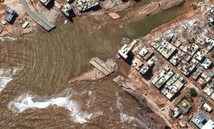
On Sept. 10, floodwaters overpowered dams and wiped out entire neighborhoods in eastern Libya, taking the lives of thousands of people and displacing more than 40,000 people, reported the Associated Press.
Maxar Technologies has responded by publicly releasing satellite imagery data that maps the affected areas to support emergency response efforts as a part of its Open Data Program.
The Maxar imagery or data distributed through the program can be quickly integrated into first responder workflows with organizations such as Team Rubicon, the Red Cross and other nonprofits.
Derna and other parts of eastern Libya were hit with extreme flash flooding the night of Sunday, Sept. 10 — an effect of the Mediterranean storm, Daniel.
The National Meteorological Center of Libya had issued early warnings for Daniel 72 hours before it occurred and notified all governmental authorities by e-mail and through media urging them to take preventive measures, reported the Associated Press.
CHC Navigation has released the C5 and C30 orthographic and oblique cameras for aerial surveys. The systems are designed to provide high-quality imaging solutions for photogrammetric applications and to complement lidar survey data.
The C5 camera is an efficient and lightweight system for aerial surveys, weighing 290 g for increased flight endurance. Its compact size of 75 mm x 63.5 mm x 102.5 mm allows easy integration into UAVs. The C30 camera’s weight is 600 g with a size of 110mm x 108 mm x 85 mm. The C30 is also designed for aerial surveying.
The C5 and C30 cameras’ universal installation design makes them compatible with a wide range of fixed-wing and rotor UAV platforms. Both cameras are supported by the CHCNAV’s BB4 Mini and P330 Pro UAVs as well as the DJI’s M300 RTK.
The Alphaport (the A-type hardware interface) enables the C5 and C30 to be easily mounted into various UAVs and converted into the DJI Skyport connector for extended compatibility.
The C5 and C30 cameras give maximum flexibility for photogrammetric applications. They can be used independently on real-time kinematic-enabled UAVs to capture high-resolution imagery or installed directly on the CHCNAV’s lidar series to colorize point cloud data. This feature allows seamless imagery and lidar data integration for a more complete view of the surveyed area.
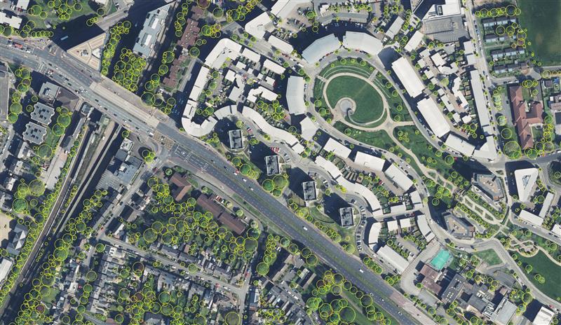
Birmingham City Council has launched a mapping portal to address the issue of tree equity across the city.
With UK national tree map data, created by aerial mapping company Bluesky International, the interactive tool allows users to identify which parts of the city have lower than average tree canopy cover and investigate possible relationships between canopy cover and other socio-economic and environmental factors. The online platform also enables users to model different scenarios and targets to identify planting opportunities and locations to increase the number of trees.
The national tree map was created using innovative algorithms and image processing techniques, from the most up-to-date aerial photography and terrain data for the whole of Great Britain and Ireland. It provides a detailed reference as to the location, canopy cover and height of trees 3 m and taller that can be applied alongside other data to establish ownership, proximity to other features or assets, and relationships between demographic, economic or social data.
National tree map data is widely used by a number of different market sectors such as local authorities, energy companies, property developers and academic and research organizations, investigating the role of trees and green spaces and their impact on health, environment and infrastructure.
Bluesky International and SkyFi have collaborated to provide access to Earth observation assets and multi-perspective imagery to users globally. Bluesky is providing its high-resolution aerial imagery, taken by aircraft-mounted cameras, to SkyFi to make available for businesses, forestry, water and land managers across the United Kingdom.
SkyFi aims to make Earth observation data more accessible to users through its growing network of satellites and aerial platforms. The company has created a data marketplace where users can purchase existing images or task a satellite to purchase a new image.
Bluesky provides a wide range of geospatial data products and services to users across the United Kingdom. GIS and CAD-ready imagery from Bluesky captures ground terrain, cityscape rooftops, fauna and more. The company’s catalogue of aerial imagery is available in England, Scotland, Wales and the Republic of Ireland.
EagleView Technologies is enhancing EagleView Cloud for government users by adding more imagery options. EagleView Cloud is a resource for government departments including tax assessment, geographic information systems and public safety.
Image: Eagleview
EagleView cloud will now include 1-inch ground sample distance (GSD) aerial imagery. The oblique imagery, usually captured at a 40°- 45° angle, provides enhanced clarity and side-angle views of buildings, homes and properties, enabling government users to view property changes and analyze roads and infrastructure to produce accurate tax assessments.
The company has also added 3-inch GSD orthogonal imagery to the platform. The orthogonal images help government users identify structural changes to buildings, additions to homes, and the condition of impervious surfaces. The images offer a top-down view and can be delivered annually or multiple times per year.
Next, EagleView Cloud aims to be available in commercial industries including insurance, construction and solar.
With Congressional approval of $17 billion in infrastructure funding, the largest single allocation ever, the scramble to win contracts is about to get red hot and AEC firms are gearing up. In this very competitive game, top engineering firms are relying on their experience, technology, business acumen and ability to execute.
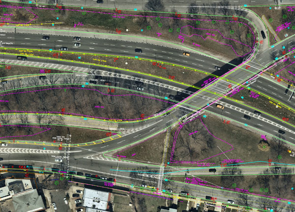
Advances in aerial mapping play a key role in how AEC firms pursue these contracts. Savvy firms have been using this technology for years. Rather than rely on lower resolution satellite imagery or local drone imagery, they use wide-area-coverage aerial maps to clearly display the detail needed to plan and execute.
Over the past decade, maps made using aerial photogrammetry have played an important role in the AEC space. Using high-performance cameras, fleets of planes capture hundreds of square miles per plane per day, provided that the weather is clear. The imagery is processed and made available to engineering companies within days of capture, allowing them to see very clear imagery.
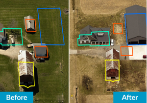
AEC organizations use different forms of aerial maps to evaluate sites, improve their survey designs, and build and maintain infrastructure (roads, highways, bridges, tunnels, overpasses, rail, airports, housing, commercial building development, water resources, parks, pavement and more). Imagine you’re a state or local government that needs to build a bridge, or a developer who wants to contract with an engineering and construction firm to build affordable housing. Why travel to perform time-consuming site evaluations when you can meet with engineering teams in your office and review hundreds of potential sites instantly using current aerial photos that show change over time?
The engineering teams point out elevation changes, the presence and height of vegetation, neighboring communities, bodies of water, ponding and more. They easily navigate from one location to another as you discuss where the entrance to the community could be, how the road network might be configured, and the proximity to retail, schools and healthcare. Within minutes you measure risk, understand the landscape, make decisions, and begin to estimate the project costs. Your teams collaborate, discuss the pros and cons, measure distances and navigate across the terrain virtually.
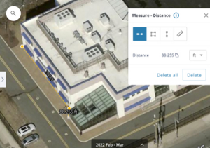
Aerial mapping provides a competitive advantage for AEC companies to win their fair share of the infrastructure bill. It also gives governments and developers the confidence they need to make the right decisions. Typically, this involves looking at sites from all angles. The classic form of aerial mapping used by engineers is a top-down perspective. Increasingly, these organizations have used oblique imagery captured at an angled perspective, which shows height.
Artificial Intelligence and Aerial Photography
Starting a few years ago, 3D imagery and digital surface models began to allow engineers to navigate through the imagery and query it based on elevation. More recently, aerial mapping has leveraged artificial intelligence (AI) to classify properties and the landscape. Do you need to see nearby construction sites? AI applied to aerial photography can do that automatically. This rich set of data includes attributes such as tree overhang, roof condition, roof material, building footprints, vegetation height, surface material, swimming pools and even solar panels.
The blend of all these imagery types and AI into a single solution makes everything discoverable. Users can search by address, city, location or point of interest. They can visualize the imagery along with lat/long coordinates and quickly switch from top-down views to obliques to 3D. As they learn more about the landscape, they begin to turn on AI attributes, gaining deeper insights.
Sometimes, the analyses go even further. Engineering organizations export the imagery to tools of their choice from such companies as Autodesk, Esri or Bentley Systems, use field-collected ground control points to ensure that it is survey grade, then use it as a base layer for their designs. They even create marketing presentations and video content to help them win the business. Current high-resolution aerial maps have become a cornerstone of how these organizations operate.
This approach provides unique advantages for engineering firms. For example, they can combine geospatial and construction datasets in a common operating environment to reduce complexity, streamline communication, ensure that all stakeholders are up to date, and check their progress toward meeting contractual obligations.
Planners have current, contextual designs and models to make accurate decisions about planning and development activities. They can view asset locations and conditions to facilitate maintenance and upgrades, leverage aerial maps inside other platforms to improve work orders and reduce field visits, and ensure regulatory compliance.
Whether it’s improving highway safety, constructing ferry terminals, improving transportation systems, developing land or building a network of recreational trails, aerial imagery provides engineering and construction companies with a competitive advantage to win new business, improve client satisfaction and meet growth targets. With $17 billion on the line, sophisticated firms are finding a way to secure their fair share of the pie.
Nearmap aerial imagery is used as a basis for survey linework. Photo: Nearmap
With Congressional approval of $17 billion in infrastructure funding, the largest single allocation ever, the scramble to win contracts is about to get red hot and AEC firms are gearing up. In this very competitive game, top engineering firms are relying on their experience, technology, business acumen and ability to execute.
Advances in aerial mapping play a key role in how AEC firms pursue these contracts. Savvy firms have been using this technology for years. Rather than rely on lower resolution satellite imagery or local drone imagery, they use wide-area-coverage aerial maps to clearly display the detail needed to plan and execute.
Over the past decade, maps made using aerial photogrammetry have played an important role in the AEC space. Using high-performance cameras, fleets of planes capture hundreds of square miles per plane per day, provided that the weather is clear. The imagery is processed and made available to engineering companies within days of capture, allowing them to see very clear imagery.
AEC organizations use different forms of aerial maps to evaluate sites, improve their survey designs, and build and maintain infrastructure (roads, highways, bridges, tunnels, overpasses, rail, airports, housing, commercial building development, water resources, parks, pavement and more). Imagine you’re a state or local government that needs to build a bridge, or a developer who wants to contract with an engineering and construction firm to build affordable housing. Why travel to perform time-consuming site evaluations when you can meet with engineering teams in your office and review hundreds of potential sites instantly using current aerial photos that show change over time?
The engineering teams point out elevation changes, the presence and height of vegetation, neighboring communities, bodies of water, ponding and more. They easily navigate from one location to another as you discuss where the entrance to the community could be, how the road network might be configured, and the proximity to retail, schools and healthcare. Within minutes you measure risk, understand the landscape, make decisions, and begin to estimate the project costs. Your teams collaborate, discuss the pros and cons, measure distances and navigate across the terrain virtually.
Aerial mapping provides a competitive advantage for AEC companies to win their fair share of the infrastructure bill. It also gives governments and developers the confidence they need to make the right decisions. Typically, this involves looking at sites from all angles. The classic form of aerial mapping used by engineers is a top-down perspective. Increasingly, these organizations have used oblique imagery captured at an angled perspective, which shows height.
Artificial Intelligence and Aerial Photography
Starting a few years ago, 3D imagery and digital surface models began to allow engineers to navigate through the imagery and query it based on elevation. More recently, aerial mapping has leveraged artificial intelligence (AI) to classify properties and the landscape. Do you need to see nearby construction sites? AI applied to aerial photography can do that automatically. This rich set of data includes attributes such as tree overhang, roof condition, roof material, building footprints, vegetation height, surface material, swimming pools and even solar panels.
The blend of all these imagery types and AI into a single solution makes everything discoverable. Users can search by address, city, location or point of interest. They can visualize the imagery along with lat/long coordinates and quickly switch from top-down views to obliques to 3D. As they learn more about the landscape, they begin to turn on AI attributes, gaining deeper insights.
Sometimes, the analyses go even further. Engineering organizations export the imagery to tools of their choice from such companies as Autodesk, Esri or Bentley Systems, use field-collected ground control points to ensure that it is survey grade, then use it as a base layer for their designs. They even create marketing presentations and video content to help them win the business. Current high-resolution aerial maps have become a cornerstone of how these organizations operate.
This approach provides unique advantages for engineering firms. For example, they can combine geospatial and construction datasets in a common operating environment to reduce complexity, streamline communication, ensure that all stakeholders are up to date, and check their progress toward meeting contractual obligations.
Planners have current, contextual designs and models to make accurate decisions about planning and development activities. They can view asset locations and conditions to facilitate maintenance and upgrades, leverage aerial maps inside other platforms to improve work orders and reduce field visits, and ensure regulatory compliance.
Whether it’s improving highway safety, constructing ferry terminals, improving transportation systems, developing land or building a network of recreational trails, aerial imagery provides engineering and construction companies with a competitive advantage to win new business, improve client satisfaction and meet growth targets. With $17 billion on the line, sophisticated firms are finding a way to secure their fair share of the pie.
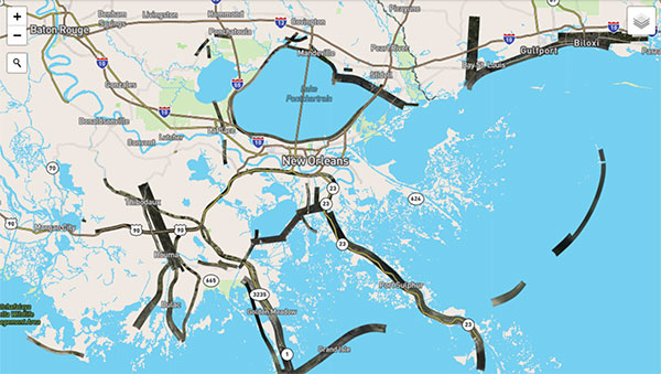
Hurricane Ida assessment imagery and data are now available. Ida was a Category 4 Atlantic hurricane from Aug. 26 to Sep. 4. (Screenshot: NOAA)
Applanix, a Trimble Company, and the National Oceanic and Atmospheric Administration (NOAA) have collaborated to provide critical information to first responders in the wake of Hurricanes Henri and Ida.
Applanix’s high-accuracy direct georeferencing (DG) technology enabled NOAA to quickly collect aerial mapping imagery to
provide valuable disaster remediation information to first responders
demonstrate the value of mapping technology in preparing for and responding to emergency situations such as hurricanes, tornadoes and other disasters.
Within hours of Hurricanes Henri and Ida making landfall, NOAA’s National Geodetic Survey collected post-storm imagery using the latest generation Digital Sensor System (DSS). The sixth-generation DSS, designed and manufactured for Applanix by Lead’Air, is the most powerful to date, thanks to several new features introduced within the solution:
simultaneous full color and near-infrared image capture using high-performance Phase One iXM 100 MP NIR and 150 MP RGB cameras
option to fly the cameras in wide coverage oblique or traditional overhead (straight line down) mode for mapping with uninterrupted measurement
embedded Trimble AP60 GNSS + inertial OEM DG solution for mapping without the need for ground control or aerial triangulation
Applanix POSPac post-processing software featuring the Trimble post-processed CenterPoint RTX correction service (PP-RTX) for centimeter-level mapping without GNSS reference stations
in-air development of raw imagery to JPEG-ready files for creating map products immediately upon landing
Lead’Air’s X-Track flight management, which enables the system to be flown outside of planned flight lines to follow roads, rivers and coastlines.
Applanix’s DG technology suite provides direct GNSS inertial georeferencing, meaning that all pixels in the aerial images taken by NOAA are mapped at their exact location on the ground.
“We have worked with Applanix for nearly 20 years,” said Michael L. Aslaksen Jr., chief of the remote-sensing division, NOAA’s National Geodetic Survey. “The level of sophistication they bring to aerial imagery and mapping keeps our team at the forefront of the industry. Their customer support team is always open to new ideas, new innovations and doing whatever it takes to get the job done.”
First responders have access to this imagery and mapping within 24 hours via the cloud (as does anyone at storms.ngs.noaa.gov) and can map detailed response plans based on highly accurate data highlighting where the greatest need lies.
Access to this turnkey emergency response imagery is available to any federal agency, municipality, insurance company or other entity that depends on highly accurate information to plan for and recover from disasters.
Nearmap will capture aerial imagery of more than 80% of the U.S. population up to three times a year, enabling clients to access 130,000 square miles of additional content, including double the urban coverage of oblique/3D content
Aerial imagery and location intelligence company Nearmap has expanded its United States coverage program to more than 80% of the country’s population. This massive boost in coverage provides companies that rely on high-resolution aerial imagery with improved decision-making capabilities that will help them save time, effort and money, Nearmap stated in a press release.
“Nearmap customers have asked us to increase the amount of the U.S. that we cover and we’re responding by doubling down on our coverage,” Tony Agresta, general manager of North America, Nearmap said. “Our clients will have access to 130,000 square miles of additional unique captured footprint in the United States.”
Overall, the Nearmap capture program will cover more than 1,740 urban areas within the United States, including more than 80% of the population with 308,000 unique square miles captured annually.
In capturing aerial imagery, Nearmap focuses on currency, consistency, coverage and ease of access. The imagery is published within days of capture, with 24/7 access through a web app, API or third-party integration.
“Around 11,300 customers worldwide rely on Nearmap to be their eye in the sky, and to provide them with the truth on the ground,” Agresta said. “We’re seeing strong momentum with new and existing customers in the United States. This massive boost in coverage reflects the broader investment and focus Nearmap has on the strategically important U.S. market.”
Features of the expanded mapping coverage include:
130,000 square miles of additional unique captured footprint in the United States, equivalent to about 63,000 football fields
double the number of urban areas covered with oblique/3D content
access to current content, with updates up to three times a year, including leaf-off and leaf-on collection
images at a high resolution, ranging from 2.2 to 3 inches.
Across the world, Nearmap will also capture more than 64% of the population in Canada; more than 90% of the population in Australia, and about 73% of the population in New Zealand.
“The expanded aerial coverage complements our city-scale 3D content, artificial intelligence (AI) data sets, and geospatial tools,“ Agresta said. “Nearmap has also recently tested in flight the next generation of our patented aerial camera system, HyperCamera3, to ensure our clients are supported by the very best technology in the market.”
In 2019, the City of Hobart Sanitary and Stormwater District (HSD) in Hobart, Indiana, recognized the benefits of geospatial technology and location intelligence to transform the city. HSD reached out to Geographic Technologies Group (GTG) to write and implement a geographic information system (GIS) strategic plan.
GTG is one of the world’s leading local government GIS companies, working to advance the science of location intelligence and geospatial technology. GTG built a GIS strategic plan for HSD using high-resolution aerial imagery from Nearmap to help build on the city’s need to deliver geospatial data to customers.
“Our content integrates easily with GTG’s applications and acts as a valuable component to their strategic planning services,” said Karl Terrey, director, Global Alliances at Nearmap. “Our imagery is refreshed multiple times per year and when combined with GTG’s technology allows governments to make decisions based on conditions in their communities in near-real-time.”
Image: Geographical Technologies Group
Before GTG, HSD was maintaining a GIS viewer web app that was not user friendly, and thus underutilized.
HSD leaders recognized the need for an interface that would serve the district as well as other city departments while being easy to navigate. Nearmap’s technology corrected this, by equipping users with controls that were customized to address all the needs of its users.
Image: Geographical Technologies Group
“Our goal has always been to solve problems, and introduce a new kind of decision support for our clients,” said James Kelt, VP of Corporate Software at GTG. “Our clients love the imagery and the more we worked with Nearmap, the more we’ve been able to provide this added value to our customers.”
With the help of the user-friendly ArcGIS Hub, where citizens could access GIS tools, and GTG’s new program, the city of Hobart gained greater citizen engagement that allowed them to find information for themselves.
Aerial imagery company Nearmap is partnering with Geographic Technologies Group (GTG), which helps local government agencies throughout the United States and Canada with geographic information systems (GIS).
GTG offers local governments with GIS services including strategic planning, consulting, comprehensive data services, mapping services, software development, training and on-call support. GTG also provides ongoing GIS maintenance for villages, towns, cities, counties, multi-regional agencies, public works and public utilities, water districts, and Native American and Alaskan Tribes.
“Our range of high-resolution aerial content — from vertical to oblique, 3D and AI [artificial intelligence] — integrates easily with GTG’s applications and acts as a valuable component to the strategic planning services offered by GTG,” said Karl Terrey, director, Global Alliances at Nearmap. “Our imagery is refreshed multiple times per year and, when combined with GTG’s technology, allows cities, towns, counties and state governments to make decisions based on conditions in their communities in near real time, at a fraction of the cost.”
Nearmap’s 3D imagery provides local governments with the ability to quickly export custom areas for use in platforms such as Esri, Bentley Systems and Autodesk. Nearmap AI enables governments to instantly identify attributes about properties required for the appraisal process. Nearmap AI Packs enable users to determine the type of access made visible in MapBrowser for items such as impervious surfaces, vegetation and solar panels at citywide scale.
Nearmap’s library of aerial imagery provides some of the most accurate imagery available with updates occurring up to three times a year throughout more than 430 markets in North America, including 700 urban and regional areas accounting for more than 70 percent of the United States population.
“Our goal has always been to break through boundaries, solve problems, and introduce a new kind of decision support for our clients,” said James Kelt, vice president of corporate software at GTG. “We began using Nearmap’s aerial imagery a few years ago because we recognized it as a way to differentiate ourselves and push the envelope. Our clients love the imagery and the more we worked with Nearmap, the more it made sense to find a way to partner so we could provide this added value to all of our customers.”
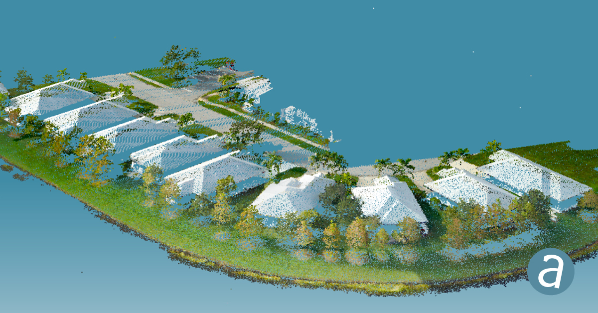
SimActive Inc., a developer of photogrammetry software, has integrated its Correlator3D product into lidar systems for drones developed by Lidar USA.
Possible configurations include two side-by-side cameras that allow matching the footprint of the lidar sensor, a particularly useful setup for corridor mapping.
SimActive’s Correlator3D software is used for automatically registering the imagery with the lidar data. Once a perfect alignment has been achieved, the point clouds are colorized using the photos.
“The ability to directly use lidar as control for adjusting image positions really is a unique feature,” said Jeff Fagerman, CEO at Lidar USA. “Correlator3D allows our clients to quickly combine lidar with data from multi-camera systems and produce high-quality outputs.”
Correlator3D software is a patented end-to-end photogrammetry solution for the generation of high-quality geospatial data from satellite and aerial imagery, including drones. Correlator3D performs aerial triangulation and produces dense digital surface models, digital terrain models, point clouds, orthomosaics, 3D models and vectorized 3D features.
Powered by GPU technology and multi-core CPUs, Correlator3D’s processing speed supports rapid production of large datasets.
Lidar USA, also known as Fagerman Technologies, is a family owned business just outside of Huntsville, Alabama. Lidar USA specializes in laser scanning, photogrammetry, instrumentation and all things geomatics.