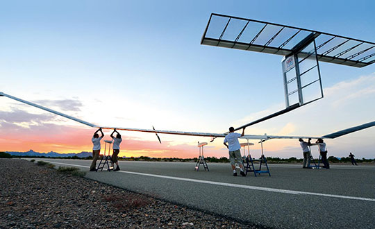
A division of the U.S. Army Futures Command is conducting stratospheric experimentation using the Zephyr ultra-long endurance stratospheric unmanned aerial system (UAS). The tests are being carried out at Yuma Proving Ground in Arizona by he Assured Positioning, Navigation and Timing/Space (APNT/Space) Cross-Functional Team (CFT), which is based in Huntsville, Alabama.
The first flight of 2022, launched June 15, demonstrated Zephyr’s energy storage capacity, battery longevity, solar panel efficiency and station-keeping abilities that will further the army’s goal to implement ultra-long endurance stratospheric UAS capabilities.
During the flight, the Zephyr accomplished a number of firsts, including
first flight into international airspace
first flight over water
longest continuous flight utilizing satellite communication controls
the farthest demonstration from its launch point while carrying a commercial, off-the-shelf payload
breaking the world record for longest duration UAS flight (26 days) set by the same aircraft in 2018. This flight has completed 36 days and is still flying over Yuma Proving Ground.
“Ultra-long endurance unmanned platforms have the potential to provide significant military capabilities and enhanced confidence as part of the Army’s diversified multi-layered architecture,” said Michael Monteleone, director of the APNT/Space CFT. “We have seen incredible progress in high-altitude platforms in recent years. This experimentation allows us to build on that knowledge by demonstrating multiple payload types, fully exploring the military utility of stratospheric operations, and modernizing areas of deep sensing, long-range targeting and resilient communications.”
Zephyr is prepared for a flight test. (Photo: Airbus)
Upcoming Second Launch. A second Zephyr flight will launch in the coming weeks and travel over the Pacific Ocean. The flight will demonstrate a prototype payload, developed by the Army Futures Command, over multiple combatant commands, and continue to inform high-altitude requirements.
The Airbus-developed Zephyr is the first high-altitude UAS of its kind, providing a persistent and adaptable longevity in the stratosphere. The experiments are performed with cooperation of the Intelligence, Surveillance and Reconnaissance (ISR) Task Force, U.S. Army Program Executive Office – Aviation, and multiple combatant commands under an Other Transaction Authority (OTA), with T2S Solutions LLC as the integrator.
The APNT/Space CFT is responsible for accelerating the delivery of advanced APNT, tactical space and navigation warfare capabilities to the soldier. Working with a core team of experts, the CFT informs technology and system requirements through continuous experimentation and prototyping, technology integration and soldier feedback. Through this process, the APNT/Space CFT supports the Army Futures Command in delivering next-generation weapons, vehicles and equipment at an accelerated rate, giving Army forces the ability to deploy, fight and win decisively against any adversary, anytime and anywhere.
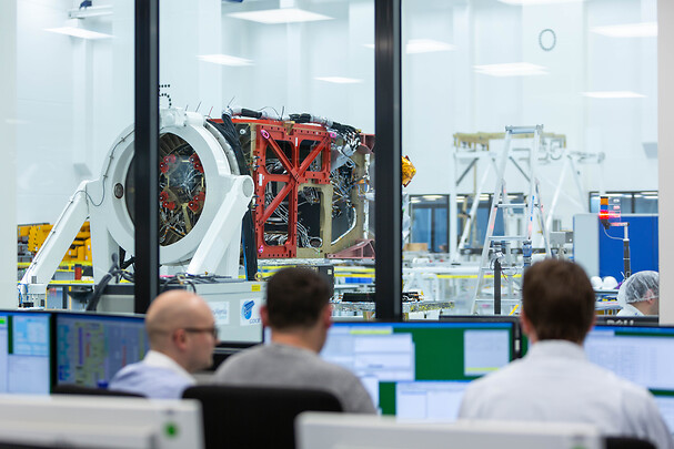
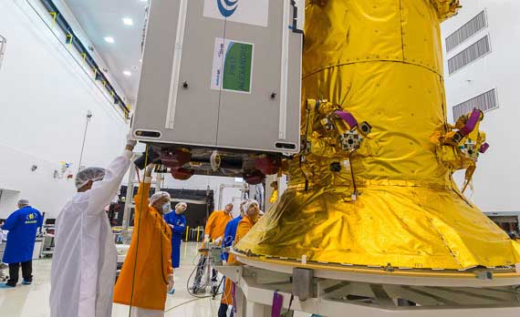
Galileo second-generation satellites will be constructed at the Integrated Technology Centre (ITC) at Friedrichshafen, Germany. (Photo: Airbus)
Airbus satellite design passes important project milestone, preparing for industrialized manufacturing concept
Airbus has successfully completed the preliminary design review (PDR) for its system concept for the second-generation Galileo navigation satellites. During this important milestone, Airbus’ proposed preliminary design and the customer’s system requirements have been fully reviewed and agreed upon. Galileo is managed and funded by the European Union.
This milestone paves the way for further verification, acceptance and qualification at the equipment and module levels. Verification at the payload level is already in full swing, with the critical design review (CDR) for the satellite structure due shortly.
In parallel, the Airbus site in Friedrichshafen, on Lake Constance, is preparing for an industrialized production line for six second-generation Galileo satellites. The satellite integration center is being upgraded to meet requirements for these satellites.
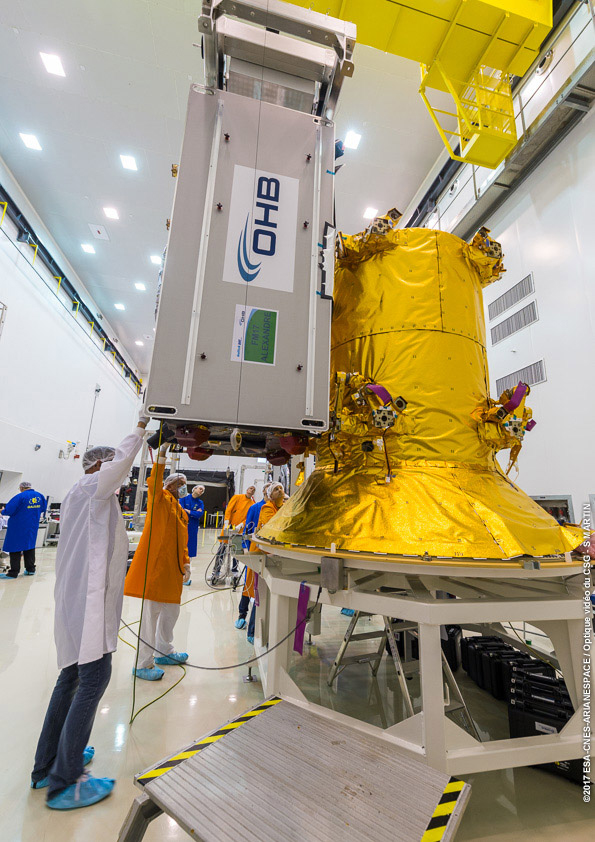
Galileo Second Generation Batch#1B satellites. (Image: ESA).
Airbus is bringing to the project more than 200 highly skilled space engineers. The first Galileo second-generation satellites are expected to launch in 2024.
The second-generation Galileo satellites will make the Galileo service more accurate, secure, dependable and adaptable. Weighing 2.3 tons, each satellite is designed to operate for about 15 years. The all-electric medium-Earth-orbit (MEO) platform from Airbus reuses building blocks from the company’s telecoms and Earth observation programs. The flexible and modular navigation payload is also based on telecom elements for beam forming and signal generation.
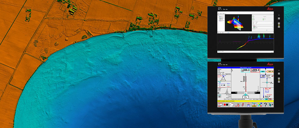
Leica Chiroptera 4X bathymetric data with Leica OC60 screen visualizing objects in near real-time during the flight. (Photo: Hexagon)
Hexagon is partnering with Airbus on a near-real-time airborne bathymetric lidar surveillance system.
Hexagon’s Geosystems division is partnering with Airbus to integrate two Leica Chiroptera 4X bathymetric lidar sensors for maritime surveillance into the C295 MSA, Airbus’ Maritime Surveillance Aircraft.
Hexagon’s new technology enables detection of underwater objects in near real time, a significant innovation in the airborne bathymetry industry, the company said.
The lidar system was developed to meet Airbus’ requirements and will first be implemented in two C295 MSA craft purchased by the Irish Air Corps. The aircraft are due for delivery to Ireland in 2023.
The system’s unique object-detection feature enables real-time lidar data visualization and analysis during flight. Being able to locate the precise position of an object allows operators to preview and analyze information captured below water immediately — a process that previously could take several days.
“When we acquired the C295 MSA, we explored various sensors to be added to our fleet, including bathymetric and topographic LiDAR. Airbus introduced us to the Chiroptera 4X, which now meets all our requirements,” said Stephen Connolly, captain of the Irish Air Corps. “The combined bathymetric and topographic lidar sensor will provide us with more details than ever before. Detecting objects close to real-time and having a clear picture of underwater activities will allow us to report directly to the Mission Support Centre on the ground and act faster to perform our duties more efficiently. The Chiroptera 4X will provide an overall better solution for the coastal maritime domain.”
Airbus and Irish Air Corps visited Hexagon’s R&D and production facility in Jönköping, Sweden, in September for the factory acceptance test. (Photo: Hexagon)
The Airbus A350 can now be equipped with the Collins Aerospace GLU-2100 multi-mode receiver. (Photo: pablorebo1984/iStock/Getty Images Plus/Getty Images)
The Collins Aerospace GLU-2100 multi-mode receiver (MMR) has received approval by Airbus, making it available as line-fit and retrofit on Airbus A320, A330 and A350 aircraft. This a major step toward Collins offering next-generation GNSS to the commercial aviation marketplace.
An MMR assists pilots in positioning, navigating and landing an aircraft. Building on the GNSS capabilities of previous MMRs, the GLU-2100 provides a satellite-based augmentation system (SBAS) and ground-based augmentation system (GBAS). This supports the integrity of the aircraft position, as well as the accuracy and availability of demanding aircraft operations such as landing in low visibility conditions.
The GLU-2100 MMR ensures that commercial aircraft can meet flight zone global mandates, while also proofing the technology by providing a solid foundation for future growth. It includes the flexible hardware baseline necessary to implement future GNSS capabilities, such as multi-frequency and multi-constellation (MFMC), and GBAS Category II/III via software-only update.
Acquisition of FlightAware tracking platform
In August, Collins Aerospace signed a definitive agreement to acquire privately held FlightAware, a digital aviation company providing global flight-tracking solutions, predictive technology, analytics and decision-making tools.
Closure of the acquisition is subject to the completion of customary conditions and regulatory approvals. Following closing, FlightAware will join Collins’ Information Management Services portfolio within the company’s Avionics strategic business unit. Financial terms of the agreement were not disclosed.
Based in Houston, Texas, with approximately 130 employees, FlightAware was founded in 2005 and is a provider of real-time and historical flight information and insights to the global aviation community. FlightAware serves all segments of the aviation marketplace through applications and data services that provide comprehensive information about the current and predicted movement of aircraft.
Through the collection, interpretation and enrichment of hundreds of sources of data, FlightAware transforms millions of raw flight data elements and delivers them as coherent, easy-to-consume flight stories. The company has a proprietary terrestrial ADS-B network with tens of thousands of receivers spanning seven continents in 200 countries and territories.
The European Commission has issued industrial contracts worth €1.47 billion ($1.97 billion) to build next-generation Galileo satellites to Airbus and Thales Alenia Space, reports BBC News.
Both companies told BBC News that they will not speak publicly about their contracts wins until documents are signed, which could take several weeks.
Each contract is for manufacture of six satellites, to orbit no earlier than 2024. They will feature digitally configurable antennas, inter-satellite links, new atomic clocks and propulsion systems that use electric engines.
Airbus and TAS built the four Pathfinder in-orbit validation satellites that first demonstrated Galileo. A consortium of OHB-System and Surrey Satellite Technology Ltd. built the first operational Galileo satellites, but the consortium ended following Brexit.
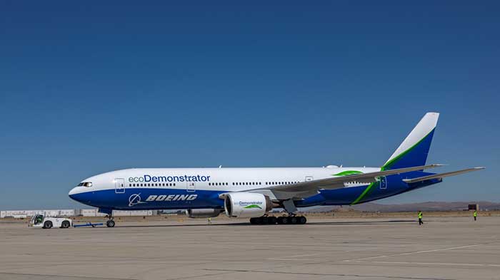
The Boeing B-777 or “Triple-7” is a big airplane — at over 200 feet long, with a wingspan of more than 200 feet, it carries more than 300 people. But getting it from one airport to its destination, which could be up to 8,500 nautical miles away, presents a significant navigation challenge. Combined Air Data and Inertial Reference Unit(s) (ADIRU) and three GPS L1 receivers form the certified primary navigation sensor cluster for the B-777-200.
Boeing has been undertaking its ecoDemonstraor program using various models of its aircraft, and in 2019 a B-777-200 was available for a number of technology demonstrations.
Along with the basic objective of testing out new fuel efficient technologies, Collins Aerospace collaborated with Boeing to demo and test their new generation navigation system using dual frequency, multi-constellation GNSS receivers.
Boeing B-777-200 ecoDemonstrator (Photo: Boeing)
The aircraft is normally equipped with buyer selected, certified GPS receivers which also track world-wide Satellite Based Augmentation System (SBAS) signals — not only improving accuracy but also improving (or reducing) the size of integrity bounds of the position solution. Currently, GPS/SBAS L1 is the only signal permitted under current FAA approved MOPS (Minimum Operational Performance Standards) for aircraft use in the US, but new MOPS standards are under development for the use of DFMC. Hence, this demonstration program would significantly aid towards validation of the new MOPS standards.
For the demo program, the Collins Aerospace GLU-2100 Dual-Frequency Multi-Constellation (DFMC) enabled multi-mode receiver (MMR) was used as the primary position source. The three GLU-2100 MMRs fitted were loaded with modified software that enabled the tracking and use of GPS L1/L5 and Galileo E1/E5a for the navigation solution using multi-frequency GNSS antennas.
The navigation mode and position integrity algorithms were also revised so the DFMC navigation outputs could be used as the primary navigation outputs for the Flight Management System and the transponder. The Collins GLU-2100 certified L1 position solution was computed in parallel and used to bound the integrity of the Collins DFMC position solution.
The demo gathered stacks of data on this first use of a DFMC receiver as the primary position source on a civil air transport aircraft. The lessons learned will undoubtable support the effort towards the introduction of dual frequency multi constellation GNSS for regular use in civil aviation.
Meanwhile, in the world of unmanned aircraft, several thing of note were recently reported, including:
Aveum Inc. rolled out its Ravn-X autonomous UAS, which is claimed to be a large, fully autonomous unmanned vehicle which can deliver satellites to low earth orbit.
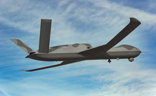
General Atomics demonstrated its Avenger UAV with autonomous CODE (Collaborative Operations in Denied Environment) capability and completed static load testing of the MQ-9B SkyGuardian wing, part of the regular qualification program for civilian aircraft certification.
Airbus Zephyr High Altitude Platform Station (HAPS) UAV completed another phase of high-altitude flight testing in Arizona.
The Ravn-X is a large UAV which apparently uses regular jet fuel, yet claims to be able to get to low-orbital altitudes. With a 60-foot wingspan, 80-f00t length and up to 55,000-pound take-off weight, this is certainly a large vehicle.
There looks to be a long tubular belly protrusion which could be a rocket motor, or fuel tank, or even a payload bay — absent any explanation of how regular air-breathing engines could reach space, we’ll have to speculate — maybe a new type of engine? Nevertheless, burning jet fuel alone, gaining space access might be difficult. Apparently the US Space Force is a sponsor and future customer, so there should be credibility to these claims.
Ravn-X new-gen space UAV (Photo: Aveum)X-37B U.S. Spaceplane (Photo: U.S. Air Force)
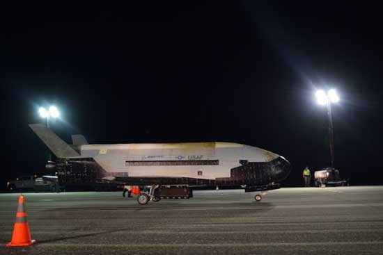
The object is to provide rapid access to space for small payloads with a reusable, autonomous, unmanned vehicle. The current vehicle is apparently 60% re-usable, soon to become up to 95%. And minimizing turn-round time is also a major target, with a claim of 3 hours being possible — quite an achievement. Of course, the U.S. already has the X-37B Orbital Test Vehicle spaceplane in operation, with a record 780 day stay in space already under its belt.
During the recent two-hour test flight of the General Atomics Aeronautical Systems Inc. (GA-ASI) Avenger UAV, equipped with tactical radio/data links and targeting capability, independence between control and mission systems was demonstrated.
The flight also tested a degree of autonomy related to the U.S. Air Force Skyborg (aircraft-UAV teaming) program. The USAF Collaborative Operations in Denied Environment (CODE) software controlled the flight for over two hours without regular ground operator inputs, and coordinated air-to-air search operations with one actual and 5 simulated aircraft.
GA-ASI Avenger UAS (Photo: GA-ASI)
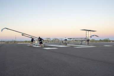
The Airbus Zephyr High Altitude Platform Station (HAPS) successfully completed another series of flight tests in Arizona in the first weeks of November. The UAV has undergone weight reductions and was equipped with revised control software which improved system robustness. The UAV is powered solely by sunlight, operates in the stratosphere and provides persistent services currently provided by satellite.
Zephyr is prepared for flight-test (Photo: Airbus)
Operational flexibility and aircraft maneuverability were demonstrated, particularly during lower altitude flying and during transition into the stratosphere. A new flight planning tool suite was put through its paces and a number of different operational concepts were tested by conducting many flights in quick succession.
These tests again demonstrated Zephyr’s capability for take-off, climb, cruise, the performance of the upgraded flight control system, descent and successful landing. Day and night on-station performance of almost 26 days was previously demonstrated during July 2018 flight tests.
It’s good to see demonstrated progress towards dual frequency GPS/Galileo civil aircraft operations through the Boeing ecoDemonstrator program, along with UAV initiatives in potential space-launch capability, autonomous aircraft-UAV teaming, and advances in the HAPS concept. All this, even with the work managed despite these interminable COVID-19 restrictions.
With 26 satellites now in orbit and more than 1.5 billion smartphones and devices worldwide receiving highly accurate navigation signals, Europe’s Galileo navigation system will soon become even better, ensuring quality services over the next decades.
Following the European Commission’s decision to accelerate development of Galileo Next Generation, ESA has asked European satellite manufacturers to submit bids for the first batch of the Galileo Second Generation (G2) satellites. The new spacecraft are expected to be launched in about four years.
Paul Verhoef, director of the Galileo Programme. (Photo: ESA)
The next-generation satellites will provide all the services and capabilities of the current first generation with a substantial improvements and new services and capabilities.
“We want an ultra-flexible and mostly digital design,” said Paul Verhoef, ESA director of Navigation.
“Developing the second generation is challenging for both industry and for ESA. In 2024, we need to launch the first satellites for this new state-of-the-art constellation.”
Invitation to Tender
Following almost 24 months of a competitive dialogue procedure with the three large system integrators involved, ESA issued a “Best and Final Offer” invitation to tender on Aug. 11 to Airbus, OHB System AG and Thales Alenia Space.
ESA is implementing a dual-sourcing approach, and two parallel contracts are expected to be signed by the end of 2020 among the current three bidders. Under the plan, each of the two selectees will build two satellites for development purposes, with options for up to 12 satellites in total.
The first satellites of the new constellation are expected to be launched before the end of 2024, together with updated ground systems to support the new satellites.
Reconfigurable in Orbit
In addition to being more powerful, the second-generation Galileo satellites will be more flexible, able to be reconfigured in orbit in order to satisfy the expected evolution in end-user needs.
A number of challenges exist for the bidders. The goal of a digital and fully flexible design represents the cutting edge of industrial capability.
Navigation Antenna Progress
A Galileo satellite undergoes its fit-check validation at the Kourou Spaceport in French Guiana. (Photo: ESA/Arianespace)
Furthermore, the required navigation antennas will have a very advanced design; much research and development by ESA has been done, yet more remains for industry.
ESA has already built such an antenna as a proof of concept at the Agency’s ESTEC technology center in the Netherlands to ensure feasibility, and the know-how has been shared with the three bidders.
“Each bidder must determine how they can best manufacture the navigation antenna, and we’ll have to see how each proposes to do it. Also, requiring a fully flexible payload is quite a challenge. No such navigation spacecraft of that type have flown yet,” Verhoef said.
Ambitious Plan
The European Commission has decided that what was previously going to be called the “transition batch” of new satellites will now become, in fact, the Galileo Second Generation satellites. The European Commission and EU Member States have already made clear that they want to be very ambitious and further increase the technical capabilities of the Galileo system.
The name change reflects of how the current batch is actually shaping up.
The transition satellites were initially foreseen as interim upgrades, to cater for the potential risk of late delivery of the later, completely new and very advanced G2 satellites.
Estimated Lifetime Increased
Based on constant measurements of the performance of the current satellites in orbit, their predicted lifetime has increased. So, together with a slight spreading out of the launches of the Batch 3 satellites — currently under construction by OHB and in testing at ESTEC —this will ensure service continuity before the new, advanced capabilities of Galileo become operational.
The second-generation satellites will gradually take over from the current first-generation satellites in the provision of Galileo services. At a future date, they will all constitute a complete constellation plus the necessary in-orbit spares.
ESA serves as the design, development and procurement agent for Galileo satellites on behalf of the European Commission, which funds the system overall.
The United Arab Emirates (UAE) will launch the first of two navigation satellites in 2021, according to the Emirates News Agency (WAM), spurred by the successful launch of a Mars probe on July 19.
The satellite is designed to demonstrate the country’s technological capabilities. A second, further enhanced satellite will be launched in 2022, said Khaled Al Hashmi, director of the National Space Science and Technology Center (NSSTC) at UAE University, Al Ain.
The satellites are the first project of Satellite Assembly, Integration and Testing Center, a collaboration formed by Tawazun Economic Council with Airbus and the NSSTC.
Funded by the UAE Space Agency, the satellites are not intended to add a navigation system — at least not right away. “We try to select a certain technology, design and develop the satellite and payload here, and will own the intellectual property rights,” Hashmi told WAM, the state news agency.
The UAE’s navigation satellite project is part of the Science and Technology Roadmap created by the UAE Space Agency and the NSSTC on developing new technologies. The NSSTC was jointly established by UAE University, UAE Space Agency and the Telecommunications Regulatory Authority (ICT-Fund).
Decision on the program came following the successful launch of the Hope Probe, which opened collaboration opportunities between the UAE and global space agencies and companies. In the first Arab interplanetary mission, the probe will reach Mars in 2021 to provide a complete picture of the planet’s atmosphere.
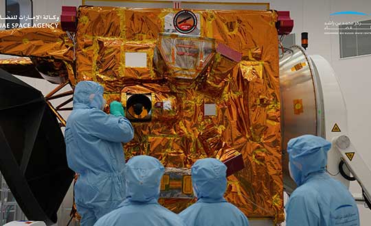
Engineers and technicians at the Mohammed bin Rashid Space Center prepare the Hope Probe for its trip to Mars. (Photo: UAE Space Agency)
The U.S. Department of Transportation’s Federal Aviation Administration (FAA) announced the eight companies that will assist the federal government in establishing requirements for future suppliers of Remote Identification (Remote ID).
Remote ID will enable unmanned aircraft systems (UAS), commonly called drones, to provide identification and location information while operating in the nation’s airspace.
The FAA selected the following companies to develop technology requirements for future Remote ID UAS Service Suppliers (USS):
“The FAA will be able to advance the safe integration of drones into our nation’s airspace from these technology companies’ knowledge and expertise on remote identification,” said U.S. Transportation Secretary Elaine L. Chao.
This initial group will support the FAA in developing technology requirements for other companies to develop applications needed for Remote ID. The applications will provide drone identification and location information to safety and security authorities while in flight.
The technology is being developed simultaneously with the proposed Remote ID rule. Application requirements will be announced when the final rule is published. The FAA will then begin accepting applications for entities to become Remote ID suppliers. The FAA will provide updates when other entities can apply to become qualified Remote ID USS on FAA.gov.
Drones are a fast-growing segment of the transportation sector with nearly 1.5 million drones and 160,000 remote pilots now registered with the FAA. The agency’s ability to develop Remote ID technology simultaneously with the rule enables the FAA to continue to build on a UAS Traffic Management (UTM) system that has demonstrated global leadership through the small UAS rule and the implementation of the Low Altitude Authorization and Notification Capability (LAANC), which automates the application and approval process for most UAS operators to obtain airspace authorizations.
Survey Copter, the tactical drones division of Airbus, will be starting production of medical protection visors using the 3D printers normally used to build drones.
The parts produced with a 3D printer, using fused deposition modeling on an ABS type plastic base, account for up to 15% of the components of a drone built by Survey Copter, the company said. More than 20 printers are being used to produce the visors.
The Survey Copter 3D printers take about 45 minutes to produce a visor. According to the company, they’re not certified from the outset as medical equipment but they nonetheless offer the required protection and, given the urgency, are being officially approved by the Montélimar Hospital in France.
The challenge is to be able to produce a visor capable of withstanding the disinfection procedures used in a hospital environment at temperatures of up to 110 degrees Celsius, without deformation or opacity, the company added.
“Providing our urgent assistance to the medical sector, faced as it is with the COVID-19 epidemic, is one of our priorities, both locally and internationally, and the reactivity of Nicolas Askamp and his teams at Survey Copter is a perfect illustration of this,” said Dirk Erat, head of communications at Airbus Defence and Space.
In addition, Airbus in Germany joined the project. The Airbus Protospace Germany and the Airbus Composite Technology Centre in Stade, together with the 3D-printing network named “Mobility goes Additive,” are now supporting this project in Spain, also coordinating the collection and transport of visors to the Madrid region.
The first two Airbus-built Pléiades Neo imaging satellites have started comprehensive environmental testing to ensure they are ready for in-orbit operation, according to Airbus.
During the tests, the satellites are subjected to extreme temperatures and vacuum, vibration and acoustic noise, as well as electromagnetic interference. This will ensure they can withstand the harsh conditions they will experience during launch and their mission in orbit.
These first two new generation very high-resolution satellites are on schedule for launch in mid-2020. They will join the Airbus constellation of optical and radar satellites, improving both the revisit and resolution capacities.
Entirely funded, manufactured, owned and operated by Airbus, Pléiades Neo will provide institutional and commercial customers with high-level insights for the next 12 years. Each satellite will be adding half a million km² per day at 30-cm resolution to Airbus’ offering.
The images will be streamed into the OneAtlas online platform, thanks to an innovative cloud-based ground segment architecture, allowing customers to have immediate access to freshly acquired and archived data as well as analytics.
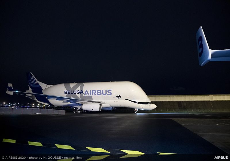
Airbus is providing safety information to all pilots, not just those of the new BelugaXL. (Photo: Airbus)
Commercial airline pilots should be ready if their GNSS interference or jamming takes place. This safety message, along with steps to take, was provided by Airbus in the January issue of its publication “Safety First.”
In the publication, Airbus is reminding pilots of the consequences and required action in the cockpit, according to Aviation Week. Loss of the GNSS signal can affect navigation and surveillance functions. While built-in redundancies will maintain position computation, up to a dozen systems and functions can be affected.
Cover: Airbus
“A loss of GNSS inputs does not lead to a map shift or an erroneous position computation by the FMS (Flight Management System). In the case of a loss of GPS signal, the FMS switches from the mixed GPS/IRS position to an IRS-DME/DME position or IRS-VOR/DME or pure IRS, in order of priority,” the experts explain in the publication.
Other affected systems can include the predictive functions of the terrain awareness and warning system, the runway overrun protection system, and ADS-B Out, in which case pilots should notify air traffic control.
Once the flight is over, pilots should report the GNSS interference event to air navigation service providers.