The Airbus-operated SpaceDataHighway has begun regularly relaying data from the Sentinel-2A satellite, after the successful end of the commissioning period.
This marks the start of the SpaceDataHighway service using all four Copernicus Sentinel satellites and the beginning of a new era for space-based imagery users.
The first two sets of Earth-observing Copernicus Sentinels-1A and -1B and -2A and -2B are signed up to this service as SpaceDataHighway’s anchor customers under an agreement between the European Union and the European Space Agency (ESA) as owners of the Copernicus programme, and Airbus as the owner and commercial operator of SpaceDataHighway.
Since using the SpaceDataHighway, the Sentinel-1 constellation has increased the amount of data it produces by about 50%. The service is also able to bring operational added-value to Sentinel-1 users by greatly improving the data timeliness for observations outside Europe. This is an important asset for users, especially when it comes to the routine monitoring of remote areas in the domain of maritime applications or assessment of natural disasters and first line response for emergency.
The SpaceDataHighway is the world’s first “optical fibre in the sky” based on cutting-edge laser technology. It will be a unique system of satellites permanently fixed over a network of ground stations, with the first — EDRS-A — already in space.
Each day, it can relay up to 40 terabytes of data acquired by observation satellites, UAVs and manned aircraft, at a rate of 1.8 gigabits per second.
The relay satellites are designed to lock on to low-orbiting satellites via laser and collect their data as they travel thousands of kilometres below, scanning Earth. SpaceDataHighway then immediately sends the collected data down to Europe from its higher position hovering in geostationary orbit, acting as a go-between.
This process allows the lower satellites to continuously downlink the information they are gathering, instead of having to store it until they travel over their own ground station. That way, they can send down more data, more quickly.
The SpaceDataHighway is a public-private partnership between ESA and Airbus, with the laser terminals developed by Tesat-Spacecom and the DLR German Space Administration. EDRS-A, the first SpaceDataHighway relay satellite launched in January 2016, offers coverage from the American East Coast to India. A second satellite will be launched in 2018.
It will double the system’s capacity and extend the coverage and redundancy of the system. Airbus is willing to expand the SpaceDataHighway with a third node, EDRS-D, to be positioned over the Asia-Pacific region.
By leveraging the Kongsberg Satellite Services (KSAT) polar ground station in Svalbard, Norway, Pléiades and SPOT constellation images are now retrieved at every orbit, resulting in ultra-fast image deliveries after collection, anywhere in the world.
In addition to this advanced reactivity, the 24/7 Service gives customers easy, immediate and round-the-clock access to a dedicated team of satellite experts who provide timely support in case of unplanned events.
“When facing crises, time is critical. With our 24/7 Emergency Service, offering an image delivery time averaging two hours after acquisition, emergency situations can be treated with an even higher priority and our customers and partners will receive their mission critical satellite images much faster,” said François Lombard, Head of the Intelligence Business at Airbus Defence and Space.
The 24/7 Emergency Image Delivery Service, relying on advanced Near-Real Time capability, was developed to answer customers’ specific requirements when facing unplanned events, geopolitical crises, natural or man-made disasters. It provides timely, reliable and accurate satellite images to assess damage and help mitigate the impact on those affected.
The service ensures that satellite resources, such as the wide-swath SPOT or very high-resolution Pléiades constellations, are booked with the highest tasking priority, guaranteeing accelerated access to data worldwide.
The service is also designed to be flexible, providing the possibility of last-minute modifications or cancellations. With this improved performance and capability, Airbus further enhances its ability to deliver timely and accurate satellite images using its smart and complete optical and radar constellations consisting of Pléiades & SPOT 6/7 satellites, DMC Constellation as well as TerraSAR-X and TanDEM-X radar satellites.
EGNOS V3 will offer improved and secure Civil Aviation Safety of Life services for the next decade over Europe. The program will ensure a full continuity of service and will be the first operational SBAS using both GPS and Galileo.
Airbus has been selected by the European Space Agency (ESA) as the prime contractor to develop EGNOS V3, the next generation of the European Satellite Based Augmentation System (SBAS) planned to provide the civil aviation community with advanced safety-of-life services and new services to maritime and land users.
Developed by ESA on behalf of the European Commission and the European GNSS Agency (GSA), EGNOS V3 (European Geostationary Navigation Overlay Service) will provide augmented operational safety-of-life services over Europe that improve the accuracy and availability of user positioning services from existing GNSS (Galileo and GPS).
EGNOS also provides crucial integrity messages to EGNOS users with alerts within a few seconds in case of system degradation, consolidating EGNOS’ position as one of the leading edge GNSS systems in the future.
Besides improved safety-of-life services, EGNOS V3 will improve robustness against increasing security risk, in particular cyber-security risks.
EGNOS V3 will ensure a full continuity of service for the next decade and will be the first operational SBAS implementing the dual-frequency and multi-constellation world standard, with both GPS and Galileo, replacing EGNOS V2 which has been in operation since 2011.
“This programme is strategic for Airbus to strengthen our position in the Navigation field. The signature of this contract is the result of more than 5 years of intense team work and investment,” said Nicolas Chamussy, head of Space Systems at Airbus. “With our consortium, we bring a large pool of resources and experience in Europe covering the successful development of critical and secure ground segment. I am confident that we will make EGNOS V3 a success story.”
As prime contractor, Airbus will be leading a consortium with partners from France, Germany, Spain and Switzerland. Airbus will be responsible for the development, integration, deployment and preparation of EGNOS V3 operations, the overall performance of the system and the Central Processing Facility, which is the heart of the real-time navigation algorithms.
During the 6.5-year contract, around 100 people and 20 subcontractors will work on delivering the EGNOS V3 system. In 2023, the single-frequency version will be available to replace the current operational version and, 18 months later, the final version in dual frequency will be delivered.
EGNOS is composed of a large network of about 50 ground stations deployed over Europe, Africa and North America, two master control centers near Rome and Madrid, and a System Operation Support Centre in Toulouse. EGNOS will also use geostationary satellite navigation payloads.
High-altitude pseudo-satellites (HAPS) are platforms that float or fly at high altitude like conventional aircraft but operate more like satellites. (Image: ESA Earth Observation Graphics Bureau)
The European Space Agency (ESA) is considering extending its activities to a new region of the sky via a novel type of aerial vehicle, a missing link between drones and satellites.
High-altitude pseudo-satellites, or HAPS, are platforms that float or fly at high altitude like conventional aircraft but operate more like satellites — except that rather than working from space, they can remain in position inside the atmosphere for weeks or even months, offering continuous coverage of the territory below.
The best working altitude is about 20 kilometers, above the clouds and jet streams, and 10 kilometers above commercial airliners, where wind speeds are low enough for them to hold position for long periods.
From such a height they can survey the ground to the horizon 500 km away, variously enabling precise monitoring and surveillance, high-bandwidth communications or back up to existing satellite navigation services.
Several ESA directorates have teamed up to investigate their potential, explains future-systems specialist Antonio Ciccolella.
“For Earth observation, they could provide prolonged high-resolution coverage for priority regions, while for navigation and telecoms they could shrink blind spots in coverage and combine wide bandwidth with negligible signal delay,” Ciccolella said.
“ESA is looking into how these various domains can be best brought together.”
“We’ve been looking into the concept for the last 20 years but now finally it’s becoming reality,” explained Earth observation specialist Thorsten Fehr.
“That’s come about through the maturing of key technologies: miniaturised avionics, high-performance solar cells, lightweight batteries and harness, miniaturisation of Earth observation sensors and high-bandwidth communication links that can deliver competitively priced services.”
Navigation engineer Roberto Prieto Cerdeira added, “There’s obvious potential for emergency response. They could also be employed semi-permanently, perhaps extending satnav coverage into high, narrow valleys and cities.”
The QinetiQ-designed and Airbus-owned Zephyr-7 solar-powered unmanned aircraft holds the world flight endurance record at 14 days. (Photo: Airbus)
European companies have already unveiled product lines. For instance, Airbus has developed the winged, solar-powered Zephyr, which in 2010 achieved a world record 14 days of continuous flight without refuelling.
The Zephyr-S is designed to fly payloads of a few tens of kilograms for up to three months at a time, with secondary batteries employed to keep it powered and aloft overnight. A larger Zephyr-T version now in preparation will support larger payloads and power needs.
The first flight is projected for 2021 for Thales Alenia Space’s Stratobus airship. (Artist’s rendering: Thales Alenia Space/Briot)
Meanwhile, Thales Alenia Space is preparing the lighter-than-air Stratobus, with its first flight expected in 2021.
The buoyant Stratobus airship can carry up to 250 kilograms, its electric engines flying against the breeze to hold itself in position, relying on fuel cells at night.
Many other firms are also developing vehicles, payloads and services. Last month saw them gathered at ESA’s inaugural workshop, together with representatives of potential customers, including the European Defence Agency, Frontex — the EU agency tasked with Europe’s border management — and EU Copernicus environmental monitoring services.
Airbus’s double-tailed Zephyr-T variant HAPS aircraft is designed to support larger payloads, keeping them aloft for months at a time. (Image: Airbus)
“This was the first meeting of its kind in Europe, with more than 200 HAPS experts” explains Juan Lizarraga Cubillos, from ESA’s telecoms area.
“We heard from them on the needs, opportunities and critical issues within the field, particularly as a complement for existing satellite services, to start preparing a future ESA programme.”
ESA regards the vehicles as a valuable way of establishing applications that complement its satellites while also accelerating space technologies through early, high-altitude flight testing.
The point was also made that market acceptance of HAPS would come down to their efficiency and cost-effectiveness — and the best way to show that would be through demonstration projects.
“We have to fly them,” remarked Alvaro Rodriquez of the EU’s Satellite Centre. “The technology is there, all the ingredients are there, now it’s time to mix them into a nice recipe.”
Thales Alenia Space’s Stratobus is topped with solar panels, powering its propellers to fly against the wind at 20 km for prolonged periods of service. (Image: Airbus)
High-altitude pseudo-satellites (HAPS) are platforms that float or fly at high altitude like conventional aircraft but operate more like satellites. (Image: ESA Earth Observation Graphics Bureau)
The European Space Agency (ESA) is considering extending its activities to a new region of the sky via a novel type of aerial vehicle, a missing link between drones and satellites.
High-altitude pseudo-satellites, or HAPS, are platforms that float or fly at high altitude like conventional aircraft but operate more like satellites — except that rather than working from space, they can remain in position inside the atmosphere for weeks or even months, offering continuous coverage of the territory below.
The best working altitude is about 20 kilometers, above the clouds and jet streams, and 10 kilometers above commercial airliners, where wind speeds are low enough for them to hold position for long periods.
From such a height they can survey the ground to the horizon 500 km away, variously enabling precise monitoring and surveillance, high-bandwidth communications or back up to existing satellite navigation services.
Several ESA directorates have teamed up to investigate their potential, explains future-systems specialist Antonio Ciccolella.
“For Earth observation, they could provide prolonged high-resolution coverage for priority regions, while for navigation and telecoms they could shrink blind spots in coverage and combine wide bandwidth with negligible signal delay,” Ciccolella said. “ESA is looking into how these various domains can be best brought together.”
“We’ve been looking into the concept for the last 20 years but now finally it’s becoming reality,” explained Earth observation specialist Thorsten Fehr. “That’s come about through the maturing of key technologies: miniaturised avionics, high-performance solar cells, lightweight batteries and harness, miniaturisation of Earth observation sensors and high-bandwidth communication links that can deliver competitively priced services.”
“There’s obvious potential for emergency response,” added Navigation engineer Roberto Prieto Cerdeira. “They could also be employed semi-permanently, perhaps extending satnav coverage into high, narrow valleys and cities.”
The QinetiQ-designed and Airbus-owned Zephyr-7 solar-powered unmanned aircraft holds the world flight endurance record at 14 days. (Photo: Airbus)
European companies have already unveiled product lines. For instance, Airbus has developed the winged, solar-powered Zephyr, which in 2010 achieved a world record 14 days of continuous flight without refuelling.
The Zephyr-S is designed to fly payloads of a few tens of kilograms for up to three months at a time, with secondary batteries employed to keep it powered and aloft overnight. A larger Zephyr-T version now in preparation will support larger payloads and power needs.
The first flight is projected for 2021 for Thales Alenia Space’s Stratobus airship. (Artist’s rendering: Thales Alenia Space/Briot)
Meanwhile, Thales Alenia Space is preparing the lighter-than-air Stratobus, with its first flight expected in 2021.
The buoyant Stratobus airship can carry up to 250 kilograms, its electric engines flying against the breeze to hold itself in position, relying on fuel cells at night.
Many other firms are also developing vehicles, payloads and services. Last month saw them gathered at ESA’s inaugural workshop, together with representatives of potential customers, including the European Defence Agency, Frontex — the European Union (EU) agency tasked with Europe’s border management — and EU Copernicus environmental monitoring services.
Airbus’s double-tailed Zephyr-T variant HAPS aircraft is designed to support larger payloads, keeping them aloft for months at a time. (Image: Airbus)
“This was the first meeting of its kind in Europe, with more than 200 HAPS experts,” said Juan Lizarraga Cubillos, from ESA’s telecoms area. “We heard from them on the needs, opportunities and critical issues within the field, particularly as a complement for existing satellite services, to start preparing a future ESA programme.”
ESA regards the vehicles as a valuable way of establishing applications that complement its satellites while also accelerating space technologies through early, high-altitude flight testing.
The point was also made that market acceptance of HAPS would come down to their efficiency and cost-effectiveness — and the best way to show that would be through demonstration projects.
“We have to fly them,” said Alvaro Rodriquez of EU’s Satellite Centre. “The technology is there, all the ingredients are there, now it’s time to mix them into a nice recipe.”
Thales Alenia Space’s Stratobus is topped with solar panels, powering its propellers to fly against the wind at 20 km for prolonged periods of service. (Image: Airbus)
Orbital Witness will receive a voucher worth €50,000 for the acquisition of satellite data and will benefit from both technical and business coaching.
The competition encourages startups to innovate and develop new applications primarily based on Airbus’ satellite data. The winning British startup Orbital Witness proposes to use satellite imagery to provide a new perspective for legal due diligence in real estate.
Launched on May 30, the goal of the four-month challenge was to create added value for new businesses focusing on themes identified as important topics for the global population, ranging from forestry and agriculture to smart cities and maritime.
More than 130 projects from five continents were entered for the competition, among which 23 startups were pre-selected based on their originality and relevance as well as their technical and commercial feasibility.
These “semi-finalists” entered a subsequent round to further develop the proposals — this ended with a second selection phase in which the six finalists were chosen.
During the final, held Oct. 20 at the Airbus PlayLab in Toulouse, the six finalists presented their projects in front of representatives of different Airbus departments, including strategy, innovation, and marketing and sales.
The other finalists were:
23insights (the Netherlands), which tracks and predicts the human footprint in forests.
Ozius (Australia), which creates new landscape intelligence by fusing a variety of remote-sensing data to identify where the environmental risks and opportunities occurred in the past, where they are today, and project where they will occur in the future.
Ursa Space Systems Inc. (U.S.), which utilizes radar satellite data to deliver global and unbiased economic intelligence to energy and financial enterprises, providing reliable information about areas of the world that are traditionally opaque.
Qirate (Italy), which enhances position appeal for boosting business locations and helps people find their ideal place to live by rating the quality of life.
Kermap (France), which uses satellite imagery to support the ecological transition of cities.
The runner-up projects also received satellite data vouchers: €20,000 for 23insights, €15,000 for Ozius, €10, 000 for Ursa and €5,000 for Qirate and Kermap.
It’s been a couple of months since we ran an update on unmanned aircraft, so there are lots of news items to dust off and maybe look at more closely.
I suppose we’ve all seen those futuristic movies with masses of orderly air traffic traveling rapidly down invisible roads hundreds of feet above cities — maybe the Jetsons first got us thinking about this vision of tomorrow? Well, unmanned flying taxi demos in Dubai certainly caught my attention. Could this be the launch of the first phase of “airborne street traffic”?
Demo UAVs in Dubai, China
The two-seater UAV built by Volocopter demonstrated in Dubai has 18 rotors, and during the five-minute demo for the media, Crown Prince Sheikh Hamdan bin Mohammed was flown at around 200 meters over sand, rather than over a populated city. There surely could be a number of safety elements yet to be implemented before we see this become operational — but you have to start somewhere.
The Volocopter demo was preceded at the beginning of this year by the appearance of a single-seat Chinese demo vehicle. This smaller eight-rotor drone by EHang took a shot at being a future “over-city” cab.
Urbain Air Project
In the meantime, Airbus and HAX, a start-up investor, are seeking innovators to participate in a four-month program to advance developments in urban-air mobility — innovations which could speed-up development of “flying cars.”
The project is looking for technologies already being developed in:
Urban air transport vehicle technology
UAV sense and avoid technology
Airport runway and landing detection systems
Emergency safety systems for airborne vehicles
Required infrastructure for airborne transport vehicles
Autonomous airborne vehicle technology
Aerial maneuver decision making and support systems
Air traffic management systems
Aerial collision detection and avoidance systems
Battery packaging and management systems for airborne vehicles
Several startups could be funded with at least $100,000 each, and will be asked to spend four months in Shenzhen, China, turning their concepts into prototypes with support from HAX and Airbus engineers.
Safety Standards?
All interesting stuff, but at some stage someone has to take a serious look at the safety standards needed to protect prospective passengers. The existing designs appear to have some flight control redundancy, and there are hints of a possible loss of data-link reversionary mode, but there might be more significant work to be done before any regulatory agency such as the Federal Aviation Administration (FAA) were to validate system reliability. But good luck to these innovators and other companies who are working towards implementing this fascinating concept.
At the other end of the drone spectrum, Renishaw Canada recently showed off a drone made of titanium and produced using 3D printing.
The Firefly is a 3D-printed titanium rocket-powered drone that can fly at nearly supersonic speeds, with onboard telemetry and a spring-released wing. The Mach 0.8 drone has been produced by the Renishaw additive manufacturing group for an unnamed North American aerospace company. The drone can apparently house a number of miniaturized sensors for data collection.
Possible applications of this unique high-speed, short-duration drone could include data collection flying into storms and hurricanes, or perhaps for longer distance surveying when launched from a future Mars rover.
Boeing Acquires Aurora Flight
And on the business front, the recent news is that Boeing is in the process of acquiring Aurora Flight Sciences Corp. Adding Aurora as an independent operation alongside Insitu will probably lead to migration of technology between the two Boeing UAS units, which is presumably why Aurora is being acquired.
Aurora has focused on electric propulsion systems and automation and autonomy for robotic operations and UAVs. Aurora has also collaborated with Boeing in the past on rapid prototyping for drones, and structural assemblies for military and commercial applications.
As a unit of the Boeing Company, Aurora technologies for long-endurance aircraft, robotic co-pilots, and autonomous electric multi-rotor UAVs will have a better opportunity to make it to product level, and wider applications should be possible for these unique capabilities.
Based in Manassas, Virginia, with facilities and offices in five other states around the United States — including R&D facilities right next to Massachusetts Institute of Technology in Cambridge — Aurora employees more than 550 people. They also have an office in Luzern, Switzerland.
FAA Regulations Revisited
Finally, according to AUVSI, in the year since the FAA released the Part 107 regulations for the operation of small UAS (sUAS), users have requested more than 1,000 waivers to work outside the parameters of these regulations. The Part 107 regulations permit users to request such waivers, provided operations can be shown to be safe. The majority of these waiver requests were to operate at night — whereas the regulations only permit operation within Visual Line of Sight (VLOS) in daylight.
AUVSI argues that certain commercial operations have only been possible through the use of these waivers, and therefore the regulations should be revised to enable normal operations without the need to grant individual waivers on a case-by-case basis. The FAA’s position may be that until such operations can be proven to be safe over time, the agency wants to know who’s exceeding which parameters, and under what conditions — hence the need for individual written applications, so that analysis of safety aspects is possible. Then subsequent monitoring will show that levels of operation may be safely exceeded on a regular basis.
This is how aviation agencies have always managed aviation safety. A UAS operator might demonstrate operational capabilities, show an acceptable safety level, and thereby prove that pushing the envelope is okay. Sometimes it can take time, but with good visibility on both sides, it’s possible that progress could be made reasonably quickly.
Farmstar, a service of Airbus Defence and Space and ARVALIS – Institut du végétal for precision farming based on satellite information, has been further improved.
New images acquired by the SPOT 6 and SPOT 7 satellites will make it possible to issue intra-field recommendations for areas as small as 1 hectare. Also, new interactive advice is provided for nitrogen input at the 1-centimeter ear stage.
Automatic and manual modulation files are accessible to all farmers via the Farmstar web portal. An additional advice for calculating the nitrogen input at the 1-centimeter ear stage enables this input to be broken down and adjusted for wheat, barley and triticale crops. The nitrogen fertilization recommendations now take into account the objectives of the Proteins Plan for wheat quality thanks to new nitrogen requirement specifications for soft wheat, to optimize how this two-fold yield–protein content objective is addressed.
These new developments come at the right time: after an extremely difficult year, due to exceptionally poor meteorological conditions, French farmers are looking to save on farm inputs while continuing to manage their crops sustainably and with a focus on environmental protection.
The number of farmers signed up for the service has constantly risen over the past 15 years. Nearly 800,000 hectares of plots were monitored by Farmstar last season, enabling more than 18,000 farmers to save time and money through precise management of the exact needs of their crops.
Farmstar is a service distributed by the cooperatives, chambers of agriculture and traders dedicated to precision agriculture and crop management developed by Airbus Defence and Space and ARVALIS – Institut du végétal, in partnership with Terres Inovia.
Throughout the season, the service provides reliable information that can be directly used by farmers to help them quickly make relevant decisions. This advice, combining satellite, UAV and aircraft imagery with agronomic expertise, exposes the real need of plants within each plot at different key stages in the crop growth and allows the right amount of inputs to be added in the right places at the right time.
EGNOS demonstration equipment aboard an Airbus ATR-42. (Photo by Tim Reynolds)
Toulouse, France, an aerospace city and the center of the French aerospace industry, was the birthplace of EGNOS, Europe’s satellite-based augmentation system (SBAS), in 1994. So it was appropriate that the first-ever EGNOS Flight Event was organized there in May by the European GNSS Agency (GSA) and the European Commission.
EGNOS is the acronym for European Geostationary Navigation Overlay Service. It is also songe — the French word for “dream’”— spelled backwards and, according to Jean-Luc Moudenc, mayor of Toulouse, that is how the name originated.
The dream is now very much a reality. Since its certification for civil aviation in 2011, EGNOS has made steady progress in implementation. Today, 111 airports in 15 countries across Europe benefit from EGNOS, and many more are preparing for implementation — 171 LPV (localizer performance with vertical guidance) and 86 BARO approaches are already certified for use.
The EGNOS Flight Event was organized in collaboration with Airbus and brought together aviation media and other sector stakeholders for a briefing and demonstration of EGNOS, how it works, its benefits for aviation and a glimpse at its future.
The state-of-the-art Airbus A350 WXB is the first wide-body airliner equipped with the SLS. (Photo by Tim Reynolds)
EGNOS for Airbus
It was clear that Airbus sees integration of EGNOS, and SBAS generally, into the avionics of its product offerings, from helicopters to the giant Beluga transport plane, as very much part of the future.
A highlight of the event was a “show and tell” with the Airbus A350 WXB — a real beauty of an airplane. Participants were given a tour of this new state-of-the-art wide-bodied airliner, including a simulation of an EGNOS-enabled LPV landing in the cockpit. Airbus test pilot Jean-Christophe Lair described the A350’s new Satellite-based Landing System (SLS) that works with SBAS such as EGNOS. This is the first time such a system has been installed on a wide-body airliner and will be supplied as a standard feature to all customers.
EGNOS is fully integrated into a common harmonised landing system interface on the A350 — the SLS — that allows the pilot to fly precision approaches like an ILS with geometrical vertical guidance down to 200 feet. This new navigation system will allow Airbus users a wider range of solutions to optimise operations and increase accessibility without any compromise on safety.
“All the systems look the same to the pilot — it is a seamless integration of EGNOS — so no human-factor issues,” said Jean-Christophe. Pilot feedback had been excellent with some 3,000 hours flown on LPV approaches using both EGNOS in Europe and WAAS in North America. “We have experienced no technical or operational issues with SBAS operations,” he claimed. “The SLS shows value every day that it is used.”
SLS/LPV is operationally equivalent to CAT 1 ILS, but brings significant additional assets above the LPV minimum such as the secure coding of the final approach segment and the fact that the SBAS/ LPV vertical profile is geometric and fixed in space. The system can also be useful for creating en-route diversions and allows creation of instrumented approaches. Overall the SLS development on the A350 XWB had been a very positive experience he stated.
Earlier Philippe Rollet, senior expert Air Traffic Management at Airbus, had said that “EGNOS was more important for helicopters than aircraft.” The enhanced EGNOS guidance enabling access to helipads in urban environments. “With EGNOS you can have a helipads everywhere and the system increases operational safety in bad weather,” he claimed. “For Airbus all new helicopter models will be EGNOS capable – it is the baseline for Airbus.”
This enhanced access facility was demonstrated via the GSA-funded GARDEN project that is using EGNOS to enable increased safety and better access for helicopters, for example, enabling air ambulances to more easily access city centre hospitals. EGNOS implementation was demonstrated in the cockpit of an Airbus H175 multi-mission helicopter used as a test-bed for GARDEN.
Technology at Work In Flight. EGNOS was also in action during a series of flights for the media using EGNOS for landing procedures on an ATR turboprop development craft. The plane was equipped with additional avionic displays in the main cabin, and this allowed the press to watch the technology at work without crowding out the pilots on the flight deck! The flight demonstration took off from Blagnac for a 15-minute circuit around the beautiful “pink” city of Toulouse before demonstrating an immaculate EGNOS LPV approach and landing.
Earlier the “press pack” had also been taken on a tour of the massive assembly plant for the Airbus A380 double-decker airliner next to the airport. Well worth a visit if you are ever in the area! In fact, Toulouse is blessed with aerospace tourism attractions such as the City of Space.
Expanding EGNOS?
The media was welcomed to the event by GSA executive director Carlo des Dorides. He emphasised that EGNOS for aviation delivers high precision at low cost. “EGNOS is Europe’s first satellite navigation system — and already has a good success story to tell,” he said. “It helps aviation to be safer, greener and more efficient.” He highlighted EGNOS’s ability to deliver continuous integrity protection in compliance with ICAO standards allowing CAT 1 approaches with more than 99 percent availability.
“Today 142 airports across Europe are benefitting from EGNOS, and the number is growing steadily,” he said. EGNOS’s success in aviation was also helping to spread the word for applications in other transport sectors such as maritime.
With a near-term target of 500 runways to be EGNOS enabled in Europe, the support available for airports and operators wanting to benefit from EGNOS was emphasised by Gian Gherardo Calini, the head of market development at GSA. During 2015 the agency has allotted €6 million to co-fund projects to implement EGNOS in aviation. A similar amount had also been allocated in 2014. GSA provided technical and educational support for implementation as well as financial assistance.
He saw the benefits being increased safety, operational enhancements, plus reduced cost and environmental impact. Widespread implementation would enable new point-to-point commercial airline opportunities.
Key to Significant Growth. EGNOS could be the key to a significant growth in general aviation in Europe. “The need to install ILS made the business case for most general aviation airfield out of the question,” claimed Martin Robinson, senior vice president of the International Council of Aircraft Owner and Pilot Association (IAOPA). There are 4,649 aerodromes in Europe and some 50,000 general aviation aircraft operating from them. In comparison to the situation in the U.S., only a small percentage the aerodromes had been. Of course, the widespread uptake of WAAS in the U.S. is a clear result of a deliberate federal strategy.
“There is definitely room for growth,” said Robinson. “EGNOS will help to provide greater access to aerodromes throughout Europe and to improve safety, but we need to be much quicker if we are to realise these benefits sooner.” He felt every general aviation airfield needed a clear business plan working towards EGNOS ability.
There was some dispute about the exact cost of implementing an EGNOS approach as it varies from location to location, but in broad terms the one-off cost of implementation seems to be equivalent to the annual maintenance cost of on-the-ground ILS equipment. With these economics, wider uptake by regional airports in Europe should be a no-brainer; however, the go or no decision often came down to individuals, said Robinson. He believes European countries need to be more willing to support the European Commission in introducing the technology. Perhaps a more region-led approach is required?
The French government line on EGNOS was given by David Comby of the French Ministry for Ecology, Sustainable Development and Energy, who said France sees EGNOS as essential part of the modernisation process for European airspace making flying safer, more efficient, greener and more cost effective. France was working hard on EGNOS implementation, and it was possible that all French runway ends (~200) would be equipped for EGNOS by 2018.
EGNOS over Africa?
The potential for expansion of EGNOS / SBAS across the globe is huge. Despite having to battle against a barrage of taxiing aircraft noise, Jean-Marc Piéplu Head of EGNOS Exploitation at GSA described the upgrade path for EGNOS from the current Version 2 to EGNOS V3. “Version three will feature new capabilities,” he said. “Dual-frequency and dual-constellation with both GPS and Galileo signals available.”
In theory EGNOS V3 could provide EGNOS / SBAS coverage for aviation to more than 90 percent of the global land surface. Piéplu indicated that if the political will was there to implement, then this extension of coverage could be accomplished in 10 years. There were no outstanding technical issues. He also said that there were no current plans to use GLONASS signals with EGNOS.
A key market could be Africa. Establishment of transport infrastructure is seen as a key enabler for sustainable development in the less-developed world, and SBAS-based infrastructure could provide a cost-effective solution to boost connectivity safely without having to invest in vulnerable ground-based equipment.
Julien Lapie from the Agency for Air Navigation Safety in Africa and Madagascar (ASECNA) highlighted that over 40% of citizens in Africa were more than 250 miles from an ILS-equipped airport. Negotiations on use of EGNOS over Africa are ongoing, but could be completed as soon as 2016.
As the not-so-subtle EGNOS advertising tag goes: It’s there. Use it.
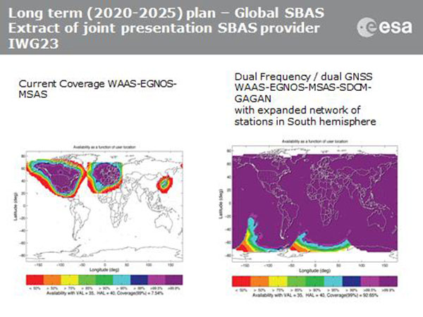
Current coverage (left) of WAAS, EGNOS and MSAS; long-term 2020–2025 (right) plan for dual-frequency, dual-GNSS WAAS-EGNOS-MSAS-SDCM-GAGAN.
SBAS Agree to Common Message
Aircraft navigation and safety will benefit from enhanced, reliable satellite navigation signals on a seamless basis across much of the world in the 2020–2025 timeframe. The 28th Satellite-based Augmentation Systems Interoperability Working Group (IWG) came to agreement on standardization of satellite-based augmentation systems (SBAS) in a meeting hosted by the European Space Agency in early April. The group planned a shift from reliance exclusively on GPS to a multi-constellation design employing Galileo, BeiDou and GLONASS after 2020.
The agreement centers around a message definition for a new secondary SBAS channel — to be known as L5, along with the current L1 — for second-generation SBAS systems, which will utilize dual-frequency multi-constellation signals, greatly increasing the accuracy of navigation systems available to airliners by largely eliminating ionospheric errors. Plans also call for an expanded network of stations in the Southern Hemisphere. The IWG document must now be accepted by the official international SBAS standardization bodies: the International Civil Aviation Organisation, the U.S. Radio Technical Commission for Aeronautics (RTCA) and the European Organisation for Civil Aviation Equipment.
The meeting also reported on the state of development of the other global SBAS systems. Along with the four operational systems — the U.S. WAAS, European EGNOS, Japan’s Multi-functional Satellite Augmentation System (MSAS) and India’s GAGAN (GPS and geo-augmented navigation system) — these comprise South Korea’s KASS, China’s Beidou SBAS, Russia’s System for Differential Corrections and Monitoring (SDCM) and the West African Agency for Aerial Navigation Safety in Africa and Madagascar (ASECNA) SBAS.
UAV Integration into Airspace
The Federal Aviation Administration (FAA) announced two new initiatives related to unmanned aircraft systems (UAS) at the Association for Unmanned Vehicle Systems International (AUVSI) Unmanned Systems 2015 conference in Atlanta, Ga., in early May.
FAA Administrator Michael Huertatold a large gathering of national journalists, “The unmanned aircraft industry is changing faster than any segment in the aircraft industry. A new project to harness that energy, the Pathfinder program, is partnering with three leading U.S. companies to expand unmanned aircraft operations in the United States.” The FAA is working with industry partners on three focus areas:
CNN will research visual line of sight (LOS) operations for newsgathering in urban areas. CNN will continue working with Georgia Tech University to improve newsgathering for all organizations.
PrecisionHawk will investigate agricultural operations for rural areas, flying outside LOS.
BNSF Railway, second-largest freight railroad network in North America, will undertake inspection of rail infrastructure, also beyond visual LOS.
Huerta said that the partners, collectively, “are trying to push the envelope, what can we accommodate safely and what can we learn from that.We’ll test a little, learn a little, then test some more. How do we see a staged implementation? To integrate unmanned aircraft, but to do it safely. We’re trying to push the edges of what we can allow, working with partners who have specific uses and resources.”
As to a timeframe to reach new UAV regulations, he replied, “I can’t comment a lot on the rule itself, but it’s fair to say that in the rulemaking comment process [closed on April 24], we received more than 4,500 comments. It’s too early to say how those comments will shape the final rulemaking.
“Assessment will be done in the coming months, perhaps by the end of the year, but that’s an aggressive timetable. That’s not accomplished in six months, nor should it take a million years.”
New Airbus EGNOS-Capable
The new Airbus A350 airliner, now entering service, comes fitted with EGNOS. The EGNOS system is being adopted by European airports to enable satellite-guided landing approaches. The A350’s Satellite Landing System allows pilots to perform precision-landing approaches guided by EGNOS or its U.S. equivalent, WAAS. The capability offers vertical landing guidance down to a minimum of 60 miles.
New Galileo Satellite on the Air
Monitoring by researchers at the German Aerospace Center (Deutsches Zentrum für Luft- und Raumfahrt, or DLR) indicates that one of the Galileo full-operational-capability (FOC) satellites launched on March 27 has begun transmitting standard L-band signals using pseudorandom-noise-code identifier 22.
The first E1 and E5 signals from GSAT0204, also known as FOC-FM4 and Galileo 8 and as NORAD object 40545, were received at an International GNSS Service Multi-GNSS Experiment tracking station in Windhoek, Namibia, at about 11:32 UTC May 21. The satellite’s signals were subsequently tracked by a station in Wettzell, Germany, and then by others.
The signals will be set unhealthy for use until satellite commissioning is completed.
News item courtesy of CANSPACE Listserv.
Euroship Gets eLoran as Backup
Container ship in port.
Ship management company EuroShip Services Ltd. has installed eLoran as a backup to GPS to ensure the safety of its vessels operating off the coast of the United Kingdom.
The trial installation may lead to implementation across the full fleet of16 vessels managed by Euroship, working routes in Northern Europe. The land-based radio navigation system is intended to seamlessly take over in the event of a GPS outage. EuroShip plans to simulate GPS outages to test eLoran provision of position, navigation and timing data automatically.
New GPS III RFP
The U.S. Air Force (USAF) has released a draft Request for Proposal for GPS III Launch Services, encompassing launch vehicle production, mission integration and launch operations.USAF reintroduces competition into the Evolved Expendable Launch Vehicle (EELV) program after more than a decade.
GPS III is the first of nine launches the Air Force intends to competebetween now and 2017, followed by 25 more from 2018 to 2022.
Compare pre- and post-earthquake imagery from Airbus Defence & Space to explore damage around Nepal. This map includes several bookmarks to help users navigate around key points of interest and landmarks that were damaged or destroyed.
Users can interactively explore demographic information about the people affected by the earthquake. The map fuses demographic data with the Shakemap from USGS to provide estimates about the population in each shake zone. Click a zone on the map to see how many people live in that area.
 This marks the start of the SpaceDataHighway service using all four Copernicus Sentinel satellites and the beginning of a new era for space-based imagery users.