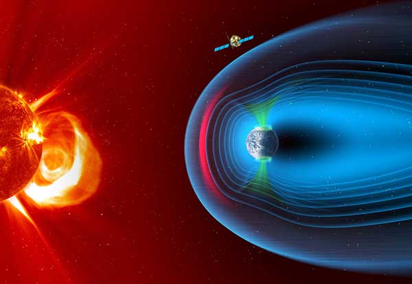
The European Space Agency has chosen Airbus to build the European component of the SMILE (Solar wind Magnetosphere Ionosphere Link Explorer) satellite.
SMILE will be the first joint satellite mission between the European Space Agency (ESA) and the Chinese Academy of Sciences (CAS), following on from the success of the Double Star/Tan Ce mission which flew between 2003 and 2008.
The objective of SMILE is to study and understand space weather. Specifically, it will look at the physics behind continuous interaction between particles in the solar wind and Earth’s magnetosphere, the magnetic shield that protects the existence of life in our planet.
Space weather can interfere with GNSS signals.
The mission is now entering a four-year period of manufacturing, testing and integration of the payload module and the platform. In launch configuration, these two components will form a 3.15-meter-high stack.
The spacecraft will have a mass of 2,200 kg and will travel in a highly elliptical orbit around the Earth. Its perigee will be at a distance of 5,000 km (from where it will download data to the Troll ground station in Antarctica and the CAS ground station in Sanya, China), while the apogee will be as far as 121,000 km (almost one third the distance to the Moon). At this vantage point the satellite will have a prolonged view of the Earth’s northern polar regions, to enable the boundary of the Earth’s magnetic field and the Northern Lights, or aurora borealis, to be imaged.
Payload in Madrid, platform in Shanghai. The payload module will be built at the Airbus site in Madrid, where the instruments will be integrated. The platform will be built in Shanghai. Both, the payload module and the platform will be integrated and tested at ESA’s European Space Research and Technology Centre facilities by a multinational team.
The science payload consists of four instruments:
The Soft X-ray Imager will obtain unique measurements of the regions where the solar wind impacts the magnetosphere.
The Ultra-Violet Imager will study the global distribution of the auroras.
The Light Ion Analyser will measure the energetic particles in the solar wind.
The Magnetometer will assess changes in the local magnetic field.
“Today, we are able to predict the weather on Earth; now it’s SMILE’s turn to help us understand space weather around the Earth and who knows? Probably one day, we will have enough data to be able to forecast dangerous solar storms that could disrupt our systems in space and on the ground,” said Fernando Varela, head of Airbus Space Systems in Spain. “We thank the Spanish Administration for their decisive and continued support to scientific missions.”
Other ESA missions, built by Airbus, such as Cluster that studied the Earth’s magnetosphere, and SOHO that studied the Sun, have already improved understanding of space weather.
Under the current plans, the spacecraft will be launched by a European Vega-C or Ariane 62 rocket in 2023.
Airbus has enlarged its high-resolution imagery portfolio following an agreement to leverage capacity from the S1-4 satellite built by Surrey Satellite Technology Limited (SSTL). The new imagery offer — called Vision-1 — delivers end-to-end imaging operations to Airbus’ customers.
Vision-1 provides 0.9-meter resolution imagery in the panchromatic band and 3.5-meter in the multispectral bands (NIR, RGB), with a 20.8-kilometer swath width. These specifications are ideal for defence, security and agriculture applications, while this extra revisit opportunity further strengthens Airbus’ satellite fleet.
“This new asset will reinforce our monitoring capabilities for sub-metre imaging, and feed our OneAtlas digital platform to provide increased freshness,” said François Lombard, director of Intelligence Business at Airbus Defence and Space.
Vision-1 operations will be coordinated by Airbus in the UK, following integration into the UK Mission Operation Centre, which operates the commercial imaging of the DMC Constellation. This is an important step for UK sovereign imaging capability, Airbus said, adding sub-meter data to the existing UK imaging capabilities.
As Vision-1 was launched in September 2018 together with NovaSAR, this opens significant opportunities for applications combining optical and radar satellite imagery.
Along with Vision-1, Airbus offers commercial access to the largest fleet of Earth Observation satellites: Pléiades, SPOT 6/7, DMC Constellation and the weather-independent radar satellites TerraSAR-X, TanDEM-X and PAZ.
The EDRS-C satellite, the second node of the SpaceDataHighway network — also known as the European Data Relay System (EDRS) — has successfully launched into geostationary orbit at 31 degrees East by an Ariane 5 rocket from Kourou, French Guiana. According to Airbus, after a test period, it will double transmission capacity of the system in order to serve two observation satellites simultaneously and provide redundant back-up for the SpaceDataHighway.
This second satellite is joining EDRS-A, which transmits the images of Earth acquired by the Copernicus program’s four Sentinel observation satellites on a daily basis.
According to Airbus, the SpaceDataHighway is the world’s first “optical fiber” network in the sky based on cutting-edge laser technology. A public-private partnership between the European Space Agency and Airbus, it is a network of geostationary satellites permanently fixed over a network of ground stations that can transmit data at a rate of 1.8 Gbit/s.
SpaceDataHighway satellites can connect to low-orbiting observation satellites at a distance up to 45000 km, intelligence UAVs or mission aircraft via laser, Airbus added. From its position in geostationary orbit, the SpaceDataHighway system relays data collected by observation satellites to Earth in near-real-time.
“The SpaceDataHighway makes our data connections more secure, more stable, more reliable, with more bandwidth and in near real time,” said Evert Dudok, head of communications, intelligence and security at Airbus Defence and Space. “The launch of our second satellite is just the start, laser communication will be a revolution for many industries.”
Full operations, including EDRS-C, are expected by the end of 2019, when its inter-satellite link and end-to-end service will be tested and commissioned with the Sentinel satellites. A third communication node is to be positioned over the Asia-Pacific region by around 2024.
In addition, from 2021, the Pleiades Neo Earth observation satellites will begin to use the SpaceDataHighway, and by the end of 2019, the system will also provide a fully European broadband communication service to the Columbus module of the International Space Station, Airbus said.
Data from Earth Monitor reveals the number of cars and trucks in an area of Amsterdam. (Image: Airbus)
The new Earth Monitor tool draws from the Airbus imagery archive and satellite tasking capabilities to provide advanced geospatial analysis, trends and detection maps.
Available as part of Airbus’s OneAtlas suite of geospatial tools, Earth Monitor enables customers to draw precise, timely and meaningful conclusions. It uses Orbital Insight’s machine learning and computer vision expertise through algorithms that detect changes in infrastructure and land use in near-real time. It can identify and count objects such as cars, trucks, roads, homes, buildings and construction sites and, soon, aircraft.
Earth Monitor can identify trends, spot patterns and track economic activity, delivering advanced geospatial analysis and change-detection maps on customized areas of interest to users in defense, intelligence and law enforcement.
Earth Monitor comes from a collaboration between Airbus Defense and Space, a French aerospace company, and Orbital Insight, a Silicon Valley startup. The OneAtlas platform combines Airbus’ constellation and tasking services with Orbital Insights’ analytic capabilities.
Orbital Insight’s algorithms draw on petabytes of data from multiple sources, such as satellite and synthetic aperture radar imagery, geolocation intelligence and vessel traffic data.
The tool’s interface enables users to create and manage projects, customize analyses and define period and measurement frequencies.
The contract marks an important step in the long-term partnership between SSC and Airbus, and extends the capabilities of both companies.
The first two very high-resolution Pléiades Neo satellites will be launched in mid-2020, followed by a second pair in 2022. They will join the existing Airbus constellation of optical and radar satellites, and will offer enhanced performance, and the highest reactivity in the market.
SSC will provide comprehensive ground segment support for the Launch and Early Orbit Phase (LEOP), as well as routine on-orbit support for Telemetry, Tracking and Control (TT&C) and data reception.
Ground Network. The core SSC ground network for Pléiades Neo will consist of the unique dual polar ground station solution of Kiruna, Sweden, and Inuvik, Canada — often referred to as “Kinuvik” as it is operated as a virtual single polar station.
The partnership also includes an option to provide potentially higher data volumes at a later stage, using the southern hemisphere station of Punta Arenas, Chile.
The optimized and highly resilient SSC ground network provides effective tasking and downloading of large data volumes more than once every orbit, enabling rapid delivery of Pléiades Neo data from anywhere on Earth.
The ground network has been designed by SSC and Airbus to complement Airbus’ Direct Receiving Stations (DRS) as well as the Airbus SpaceDataHighway relay satellite system, while being flexible to adapt to changing seasonal needs and to give critical network diversity.
“The Pléiades Neo constellation will be adding two million km² per day at 30-cm resolution to Airbus’ imagery offering. As tasking and downloading will be possible in every orbit, up to 60 times a day for the constellation, we need to rely on very efficient commercial polar communication services,” said François Lombard, head of Intelligence Business at Airbus Defence and Space.
“Pléiades Neo is a cutting edge very high resolution Earth Observation constellation, and this represents a huge milestone in the close cooperation between Airbus and SSC. We are proud to be able to support Airbus in providing such critical optical imagery for the global marketplace”, said Stefan Gardefjord, CEO at SSC.
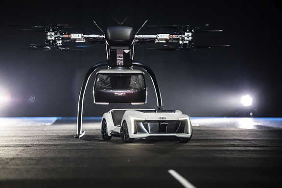
Audi, Airbus and Italdesign presented for the first time a flying and driving prototype of Pop.Up Next, a flying taxi. The companies demonstrated the concept at Drone Week, held Nov. 27-29 in Amsterdam.
The concept combines a self-driving electric car with a passenger drone. In the first public test flight, the flight module accurately placed a passenger capsule on the ground module, which then drove from the test grounds autonomously.
Photo: Audi
The demonstration was done with a 1:4 scale model. But as soon as the coming decade, Audi customers could use the flying taxi service in large cities — in multi-modal operation, in the air and on the road, without changing vehicles.
“Flying taxis are on the way. We at Audi are convinced of that,” said Bernd Martens, Audi board member for sourcing and IT and president of the Audi subsidiary Italdesign. “More and more people are moving to cities. And more and more people will be mobile thanks to automation. In future senior citizens, children, and people without a driver’s license will want to use convenient robot taxis. If we succeed in making a smart allocation of traffic between roads and airspace, people and cities can benefit in equal measure.”
To see what an on-demand service of this kind could be like, Audi is conducting tests in South America in cooperation with the Airbus subsidiary Voom. Customers book helicopter flights in Mexico City or Sao Paulo, while an Audi is at the ready for the journey to or from the landing site.
“Services like this help us to understand our customers’ needs better,” Martens said. “Because in the future, flying taxis will appeal to a wide range of city dwellers. With Pop.Up Next we are simultaneously exploring the boundaries of what is technically possible. The next step is for a full-size prototype to fly and drive.”
Audi is also supporting the Urban Air Mobility flying taxi project in Ingolstadt. This initiative is preparing test operations for a flying taxi at Audi’s site, and is part of a joint project of the European Union in the framework of the marketplace for the European Innovation Partnership on Smart Cities and Communities.
The project aims to convince the public of the benefits of the new technology and answer questions concerning battery technology, regulation, certification and infrastructure.
Airbus Defense and Space’s edited WorldDEM database, along with the WorldDEM4Ortho dataset, are now available for streaming. WorldDEM is a single-source digital elevation model.
According to the company, access to the WorldDEM and WorldDEM4Ortho of the entire Earth’s landmass facilitates a wide range of applications, such as line-of-sight analysis, hydrological modeling, satellite imagery orthorectification and more.
The WorldDEM dataset corresponds to a hydro-enforced digital surface model with water surfaces of lakes and reservoirs set to a single elevation. Rivers and canals are flattened with monotonic flow, oceans are set to zero and coastal infrastructure features are removed.
WorldDEM4Ortho, which is based no the global WorldDEM dataset, is tailored to orthorectification of high and very high- resolution optical and radar satellite data. According to Airbus, it enables corrections of all distortions induced by the topographical variations of the Earth’s surface and the satellite orientation when acquiring the image.
Airbus Defence and Space is a division of Airbus responsible for defence and aerospace products and services.
FAA also warns about drones interfering with public safety.
The Federal Aviation Administration (FAA) has announced nine new partners to its Low Altitude Authorization and Notification Capability (LAANC) initiative, a collaboration between the FAA and the drone industry that provides near real-time processing of airspace authorizations for Part 107 drone operators nationwide who fly in controlled airspace.
Following the FAA’s successful prototype, the initiative was simultaneously opened to additional air traffic control facilities and to new industry partners. The five-month onboarding process that began in April resulted in nine new LAANC partners — Aeronyde, Airbus, AiRXOS, Altitude Angel, Converge, DJI, KittyHawk, UASidekick and Unifly.
The nine join five companies — AirMap, Harris Corp., Project Wing, Skyward and Thales Group — that have already met the technical and legal requirements to provide LAANC Services.
LAANC uses airspace data, including UAS facility maps, which shows the maximum altitude around airports where the FAA may authorize operations under Part 107 in controlled airspace. The program gives drone operators the ability to interact with industry developed applications and obtain near real-time authorization from the FAA.
The FAA next year will accept applications from parties interested in becoming LAANC service providers from Jan. 7 to Feb. 8 and from July 8 to Aug. 9. This is not a standard government acquisition; there is no Screening Information Request (SIR) or Request for Proposal (RFP) related to this effort.
In a different announcement, the FAA said that drone pilots who interfere with fighting wildfires, law enforcement efforts, or other first responders such as medical flights now are more likely to face serious civil penalties, even for first-time offenses.
Deterring interference with first responders is critical as drone use expands exponentially. Firefighting aircraft trying to contain a wildfire have to suspend flights when a drone enters the area to avoid a possible mid-air collision. A drone flying over a crime scene or accident site can hamper police or medical aircraft operations.
Ultimately, interference by a drone can cost lives.
The FAA has provided guidance for agency personnel who handle possible drone violations to refer all cases involving interference with first responders to the FAA Chief Counsel’s office for possible enforcement action.
In July 2016, Congress authorized the FAA to impose a civil penalty of not more than $20,000 for anyone who operates a drone and deliberately or recklessly interferes with wildfire suppression, law enforcement, or emergency response efforts.
Under FAA guidance, inspectors generally use non-enforcement methods, including education, for correcting unintentional violations that arise from factors such as flawed systems, simple mistakes, or lack of understanding.
However, given the potential for direct and immediate interference with potentially life-saving operations where minutes matter, offenders will immediately be considered for enforcement actions. Enforcement actions can include revocation or suspension of a pilot certificate, and up to a $20,000 civil penalty per violation.
The attack seems to have been mounted by those operating two small six-rotor UAVs similar the DJI Matrice 600 — one was certainly carrying explosives because it was videoed exploding. These drones showed up somewhere near Maduro and disrupted not only the president’s speech, but also broke up the parade with participants running for cover.
One drone seemed to collide with an apartment building, fell to the ground, and then fire broke out in an apartment on the first floor. Firefighters apparently disputed a drone explosion saying that a propane gas tank had exploded inside an apartment, but images show a significant hole blown in the wall below the apartment window.
A number of discrepancies could suggest that the incident was staged, but there were injuries to several in the parade below where the first drone exploded, and the apartment fire was only 400 meters from Maduro’s review stand. The “apartment drone” appeared to behave as if control had been lost, possibly due to anti-drone jamming. Check out pictures, a video and a comprehensive analysis of these events on Bellingcat here.
Zephyr-S launched for flight test. (Photo: Airbus)
Meanwhile, on a more drone-positive note, the Airbus Zephyr S pseudo-satellite, solar-powered UAV achieved a world endurance record flight which was just 3 minutes short of 26 days, eclipsing a previous record of 14 days set by a Zephyr prototype. The ultra-lightweight UAV took off July 11 July and landed Aug. 6. This is likely the longest ever flight by an air-vehicle without refueling (balloons and spacecraft excepted).
The Zephyr S is the first of three such vehicles built by Airbus for the U.K. Joint Forces Command. The Zephyr-S flies around 70,000 feet in the stratosphere, powered solely by sunlight, and is aimed at providing short turn-around, satellite-like communications and observation services for both commercial and military customers. The potential exists to support disaster monitoring of fires, earthquakes, oil spills and the like, and to connect almost everywhere in the world that doesn’t already have established communications.
Following evaluation of the flight test results, further flights are planned from a new base at Wyndham airfield in Western Australia. The aircraft is extremely light and does not have an undercarriage, so it’s hand launched and retrieved under minimal wind conditions.
Joe Lee and paramedics UAV pilot Scott Mcleod confer before a simulated medical rescue scenario. (Image: Kongsberg Geospatial)
Meanwhile, at a deserted airfield near Pembroke, Ontario, Canada, a simulated disaster exercise, led by a Royal Canadian Mounted Police (RCMP) incident commander and supported by personnel from Transport Canada and the National Research Council, was evaluating a new air traffic management system supplied by Kongsberg Geospatial from Ottawa.
Integrating drones with disaster management air traffic is one aspect of the Emergency Operations Airspace Management System (EOAMS), a situational awareness system which provides first responders with situational awareness of the airspace around a disaster scene. The system integrates real-time data from a number of sensors, including 3D airborne radar, ground radar, ADS-B (Automatic Dependent Surveillance — Broadcast) sensors, video and GPS. Real-time information was presented to participants on regular computer displays and through a Microsoft HoloLens “mixed reality” visor.
Drones were flown beyond visual line-of-sight (BVLOS) at up to 2 km away from the airfield while the trial emulated emergency scenarios including a plane crash, a medical emergency, and the protection of a VIP threatened by an approaching, unauthorized drone. Drones were operated by the RCMP and local paramedics.
The EOAMS system displayed ground tracks and the identity of a variety of emergency aircraft, and emergency ground vehicles, and enabled safe flight of UAVs within the same airspace. Non-participating drones in the area of the disaster were also identified as possible threats to police and medical aircraft involved in the recovery efforts.
The RCMP and paramedic pilots flew consumer-model drones including the DJI Mavic to test the system’s capacity to detect small drones. Position outputs from these drones were used to verify the accuracy of the EOAMS-displayed plots. A light aircraft was also used to simulate different airborne assets, including a water bomber.
What was learned in the trials will be useful in further development of future emergency airspace management systems for use by first responders, police services and other government agencies in Canada.
RoboTiCan, an Israeli start-up, has developed a unique way of dealing with unwelcome, unidentified drones that intrude into sensitive airspace. With ground-based radar detecting and tracking an incoming UAV, its large, robust drones use machine vision and artificial intelligence technologies to identify threats and then physically attack them.
This video provides — complete with dramatic accompanying music — an insight into how their “Goshawk” drone engages, attacks and by brute force, disables smaller drones in flight.
At first encounter, the Goshawk octocopter appears to also be disabled by an intentional collision with a small UAV, but subsequent encounters demonstrate how it hones in on, collides with, and disables its target and recovers to attack again.
Compared to bird behavior, especially in the spring when nesting birds use similar tactics to defend their eggs or chicks, it does seem that its mode of operation could be very much like a hawk attacking smaller birds — hence its name.
The Goshawk uses strong, fiber reinforced blades to enhance impact survival, while its smaller drone victims may have plastic props. Overall, it’s large, has multiple blades, seems to use an attack move just before impact, and it recovers well. So control algorithms appear to have been enhanced for collisions and recovery. Its targets seem to immediately lose lift and control before they hurtle towards ground impact.
Not surprisingly, RoboTiCan appears to be positioning its marketing towards military customers, but combining this aggressive take-down capability with a high-quality drone detection/location system might also be a winner for civilian/government drone intrusion defense — Mr. Maduro, take note!
To sum up, we have more bad press for UAVs being used as offensive weapons, interesting progress towards pseudo-satellites as Zephyr-S completes 26 days aloft in the stratosphere, another UTM (UAV Traffic Management) system trial aimed at better air traffic control for disasters, and another way to bring down unwanted drone threats.
This last solution might be a better deterrent for negligent or intentional operators who stray into inadvisable airspace. The potential destruction of the drone might just get some recreational flyers to think twice and perhaps reduce these problems.
A LinkedIn post from the company suggests theater-goers “Keep an eye on the scene where Tom Cruise flies a helicopter through a narrow canyon to catch our Compact GNSS Antenna in action!”
Above is a behind-the-scenes video that shows how Airbus helped Cruise, an actor known for doing many of his own stunts, learn to fly a helicopter and navigate a treacherous dive sequence (with the aid of the NovAtel receiver).
(From left) Francois Lombard and Dirk Hoke, Airbus, sign agreement with Will Marshall, Planet.
Airbus and Planet have entered into a partnership to facilitate access to each other’s data and the co-development of new geospatial solutions.
The companies are establishing a framework agreement to explore opportunities for joint cooperation in new and existing markets, product offerings, sales and marketing efforts.
Both companies aim to provide a comprehensive suite of global satellite data at multiple temporal and spatial resolutions, and develop new analytic products for a wide range of applications to benefit their customers.
Benefitting from both companies’ constellations, customers will have access to the entire Earth’s landmass every day at 3m resolution with PlanetScope satellites, as well as to intra-daily sub-meter resolution imagery with Pléiades and SkySat constellations.
In addition, they will also have the capability to order images with resolutions of 1.5m (SPOT 6/7), 5m (Rapideye) and 22m (DMC Constellation).
Lastly, TerraSAR-X, TanDEM-X and PAZ radar satellites will allow the acquisition of images regardless of weather and daylight conditions, ensuring access to any place on Earth independent of cloud coverage.
“By combining our strengths, we will provide a key capability to address all market needs, both in terms of data and value-added products, and to best serve our clients, whatever their industry and their requirements,” said François Lombard, director of the Intelligence Business at Airbus Defence and Space.
“Airbus and Planet are truly complementary partners. Airbus brings long-standing success in serving reliable, high resolution remote sensing, and Planet brings its unique global coverage and temporal cadence, as well as agile aerospace iteration to get sensors quickly to space,” said Will Marshall, CEO and co-founder of Planet. “Together we will be able to deliver sophisticated offerings to fit customer needs across international markets.”
Airbus Defence and Space is celebrating the 25th anniversary of Eagle Vision, its lightweight deployable imagery downlink ground station designed to process and distribute commercial satellite imagery in near-real time to support U.S. Air Force and Air National Guard missions in homeland security, combat and disaster relief.
Eagle Vision allows downloading and processing of unclassified commercial satellite imagery directly in the field, as the satellite passes overhead, supporting military leaders, even in remote areas and non-anticipated operations. Imagery provided by this system supports wartime operations, natural disaster and relief efforts as well as Homeland Defense preparations.
“Today we celebrate an uninterrupted success since 1993,” said François Lombard, director of the intelligence business at Airbus Defence and Space. “Since then, Eagle Vision has become a valuable source for commercial imagery exploitation for the U.S. Air Force and many entities within the U.S. government, to provide fresh, near-real time satellite data for information extraction in preparation for mission critical applications.”
The system receives and processes SPOT 6 and 7, TerraSAR-X and Pléiades images, and is also capable of processing Landsat, Radarsat, RapidEye, Cartosat, Ikonos, Cosmo-SkyMed and Resurs-DK data.
The Eagle Vision Program has been a valuable asset within the U.S. Air Force for the past 25 years, the company said. The program enables warfighters, first responders and planners to have situational awareness so that they can plan, execute and deliver mission resources efficiently and effectively, Airbus said.
Five Eagle Vision systems have been developed and sustained 24/7 by Airbus Defence and Space for the last 25 years. They are assigned to:
Ramstein Air Base, Germany
San Diego Air National Guard Station, California
McEntire Joint National Guard Base, South Carolina


 Eagle Vision allows downloading and processing of unclassified commercial satellite imagery directly in the field, as the satellite passes overhead, supporting military leaders, even in remote areas and non-anticipated operations. Imagery provided by this system supports wartime operations, natural disaster and relief efforts as well as Homeland Defense preparations.