How AI and machine learning algorithms redefine the way utility companies manage their infrastructure
By Jaro Uljanovs, Lead AI Developer and Data Scientist, Sharper Shape
Artificial intelligence (AI) boasts a wide range of potential applications, across nearly every industry imaginable — healthcare, automotive, retail, even fast food. But it’s the utility industry where AI and machine learning (ML) are beginning to demonstrate some of their most impactful effects on many aspects of the business. Power companies are increasingly leaning on AI to improve their electricity delivery and prevent potential wildfires, and AI is actually enhancing, rather than eliminating, human jobs.
From data collection and analysis to their presentation of actionable insights, AI and ML algorithms are quickly redefining how utility companies manage their electric infrastructure.
Consolidating and classifying data
Utility companies oversee massive infrastructure networks, comprising poles, conductors, substations and transmission and distribution lines that span thousands of miles. The vegetation surrounding this key infrastructure must also be monitored, as it presents a danger of fire or outage.
Taking a comprehensive snapshot of these assets means utilizing a variety of different sensors for network inspections. These sensors include lidar, color (RGB), hyperspectral and thermal imagery.
This allows the system to capture everything — from vegetation proximity, to infrastructure assets, to individual components (such as insulators on poles) and their operational integrity, to hot spots indicating potential fire risks.
That’s a lot of data to capture, catalog and process. And there are a lot of individual elements within that data — even in just one image — to pinpoint and classify, let alone do so accurately. Classifying billions of data points across all of those images is an impossibly time-consuming task to do manually.
Photo: shaunl/E+/Getty Images
AI and ML tools can accomplish that same work — scanning thousands of images collected across thousands of miles of utility infrastructure — in seconds. Lidar point cloud segmentation can detect conductors (quite a difficult component-type to segment) with an accuracy of over 90%, while hyperspectral image segmentation can identify vegetation species with an accuracy of up to 99%.
More than that, when paired with drone sensors, these algorithms can also improve the upfront collection of images and data. AI and ML tools help to adjust sensor positioning in real time, in the event a signal is lost or the drone veers slightly away from its inspection flight path.
By helping to readjust the sensors’ bearings while in flight, AI not only ensures more accurate data collection, but also that the flight doesn’t need to be done again or prematurely ended because of faulty data collection, saving time and money. AI pinpoints any faults in the sensors or the drone’s flight path while in the air, recalibrating as needed and identifying individual elements within the data as it comes through the sensor’s video feed.
Breaking down silos to create a holistic data approach
Key to all of this is eliminating the silos that tend to naturally build up between different data segments. In the utility inspection space, asset management, vegetation management, different sensors and so on all produce their own disparate, walled-off sets of data.
When data is kept siloed like this, it becomes unnecessarily difficult if not impossible for teams to derive companywide insights or conclusions from the information being collected. And what good is all that data if it can’t be used to check against itself and enhance other sets of data?
Good data management can’t exist in a piecemeal approach. It needs to be holistic, and AI provides the impetus to make that happen. AI provides a central resource for pooling all these data sources together, making it easier to cross-analyze for potential problems — like wildfire-prone vegetation or damaged components. When these issues are collected in one system, it becomes much easier to identify faults and resolve them — and do so far faster than it would be to manually sift through countless images of poles or vegetation maps.
And for all the stereotypical concerns about AI eliminating work for human beings, at utility companies AI actually enhances the role that people have to play in the network inspection process. Because the AI is what analyzes the data, it’s not something that is dependent on the potentially biased expertise of a professional human inspector, nor is it prone to fatigue and the anomalous results that can come from that. But at the same time, AI can’t do everything itself. It’s a tool for presenting clearer, more accurate and more actionable information for the people to then act on with their own judgment.
There’s a lot of easy-to-make assumptions, both good and bad, about AI. But at the end of the day, what AI really means for the utility industry is a more efficient and effective tool for providing the right information about a power company’s infrastructure — its transmission and distributions lines, its poles, and its nearby vegetation — into the hands of its key decision makers.
Terra Drone Corporation has launched a new UAV and artificial-intelligence (AI)-based solution designed for maintenance of power transmission and distribution equipment.
The solution was developed based on market gaps identified after inspecting more than 90,000 kilometers of power lines beyond visual line of site (BVLOS) throughout the world.
Acquired data is automatically processed and analyzed by artificial intelligence algorithms trained to detect crossovers at the bottom of transmission lines, buildings and construction machinery.
The system identifies rust on bolts, loosening and missing tower parts, bird’s nests and more. It then generates a smart report highlighting areas that require action. The error (identified anomaly) detection system is accurate up to 92.5%.
The algorithm for an area is developed through a process identifying anomalies in a training data set of 1,500 images. This allows for a custom solution to be created for the end client where all pertinent anomalies are identified and reported.
The development and training of the algorithm only need to be completed once for a particular type of asset and can be implemented easily at different locations on similar assets.
With such a high-precision algorithm, the productivity of AI processing allows for fast actionable results to be provided to clientele. Clients also have the ability to identify the appropriate security protocols for data storage in either a cloud-based or on-premises storage environment. These protocols can then be implemented in a custom client-specific solution.
Loosening and missing tower parts identified by high-accuracy detection system (Photo: Terra Drone)
Power transmission and distribution companies must conduct periodic inspections of power line infrastructure to ensure reliable electric power distribution, although the conventional methods of deploying ground staff or low-flying helicopters to complete the inspections, they are typically cost-prohibitive. Conventional helicopter and boots-on-the-ground service also pose HSE concerns with low flying helicopters and people working in the field. UAV service and AI inspection can aid in minimizing HSE concerns by reducing the number of workers in the field and eliminate low level manned helicopter missions.
This solution has been built from ground up with the aim to simplify and streamline the maintenance work for transmission and distribution facilities.
Aerial imagery business Nearmap has launched its new 3D product to streamline the way industries such as urban planning, architecture, construction, government and councils view and shape cities across Australia and the U.S.
The company is also previewing its groundbreaking artificial intelligence (AI) technology at its customer event Navig8.
Nearmap 3D allows customers to stream and export 3D imagery on demand at massive scale through its proprietary MapBrowser web application. Because the imagery is updated frequently, businesses can work with the most current information to make more informed decisions.
Nearmap’s new AI technology is turning millions of aerial images — captured over a decade and multiple times a year — into valuable datasets. The datasets can be used to more accurately and efficiently measure change and quantify attributes, such as solar panels, pools, roofs or construction sites.
Organizations ranging from small businesses to large companies and cities will be able to take advantage of AI-driven location intelligence.
“Product innovation is in our DNA. Everything we do has the customer at the core,” said Tony Agresta, executive vice president of product at Nearmap. “Our customers’ worlds are evolving every day. We need to keep innovating to continue to give our customers a competitive advantage through technology breakthroughs like the ones we are sharing today at Navig8.
“Nearmap 3D is the result of a significant investment in R&D, but also listening to our customers and what they need to transform the way they work,” Agresta said. “Accessing 3D imagery up to now has typically been an arduous, time-consuming and expensive process — but not anymore. This represents the single largest, most frequently updated footprint of 3D accessible through a browser. The ability to measure in 3D space, size up an area and then export Nearmap 3D for use in other platforms will transform the aerial imagery market.
“The AI technology that we’re working on will allow organizations to identify locations with specific attributes and in so doing, reduce site visits, generate more leads, and eliminate the time involved to inspect properties manually. Nearmap AI does the heavy lifting so you don’t have to,” Agresta said.
Composite aerial image of Perth, Australia. (Image: Nearmap)
Instant access to 3D through MapBrowser
Nearmap is making 3D imagery accessible to anyone, in the same way it has with 2-D. While Nearmap has offered 3D imagery since 2017, this new iteration of the technology allows users to instantly stream 3D content at massive scale via its MapBrowser web application.
The lightweight platform offers customers an immersive 3D experience, allowing them to visualize cities in 3D from any direction, measure distances, and immediately export a custom area in a variety of 3D formats at unprecedented speed — the download time is a matter of minutes for most requirements and only a few hours for very large footprints.
“It’s like switching from DVDs to streaming services,” said Tom Celinski, executive vice president of technology and engineering at Nearmap. “Our camera technologies have been capturing 3D since 2017, but now our secret sauce is bringing it onto MapBrowser, allowing users to easily and instantly stream this content with many export options. Now users can visualize, measure, define a custom area, export our 3D and use it in their workflows with other commercial platforms and tools. We’re helping 3D experts and novices alike access reality like never before, and this is an important next step in our Reality as a Service journey.”
Nearmap 3D comes with an extensive library, covering more than 400,000 square kilometers. It is updated once a year and covers major urban areas in Australia and the U.S.
“We live in a 3D world, we think in 3D, and so we have to ensure that our products give the closest representation of reality as possible,” Celinski said. “That means businesses that rely on visualizing 3D content, like architects, for example, can now access up-to-date 3D models instantly and export them in just minutes. In a tender process, for example, that can be the difference between winning a new project or not. The opportunities for Nearmap 3D are endless.”
3D image of Manhattan. (Photo: Nearmap)
A living data set
Nearmap AI technology is the result of more than two years’ worth of research and development, and a team of close to 20 data scientists and machine learning engineers. The team, led by Dr. Michael Bewley, is using the petabytes of imagery that the business has captured over the past 10 years and turning it into a living dataset to accurately identify changes or quantify attributes from the Nearmap library of aerial imagery.
Nearmap has built highly accurate machine learning models and deployed them on a massive scale. The automated process, and the constantly learning engine, means that the AI technology can be applied to any new geography. Nearmap also applies the models to new surveys, generating fresh results with current imagery.
To date, Nearmap has performed analysis on over 1 million square kilometers of imagery across Australia and the U.S. (which constitutes about 80 million properties) and is performing more analysis every day. Nearmap is now inviting customers to take part in a beta program to experiment with various use cases.
“We don’t prescribe how our technologies or content can be used by our customers,” said Michael Bewley, director of AI systems at Nearmap. “Our solar customers could use the AI technology to easily identify where and when solar panels have been installed for maintenance jobs, to prospect new clients in an area where solar energy’s popularity is on the rise; or a government entity that previously had the arduous task of tracking swimming pools or construction in their jurisdictions will be able to do it automatically.”
“But this is the tip of the iceberg — we’re just getting started. This technology is going to profoundly change the way that cities are built,” Bewley said. “Our plans include delivering AI results in many forms, much the same way we deliver our imagery today.”
Both technologies will be presented at Nearmap’s flagship event, Navig8, in Perth on June 6, Melbourne on June 11 and Sydney on June 13.
Teledyne Optech, Teledyne DALSA and Teledyne Scientific & Imaging, all part of the Teledyne Imaging group, will share a combined presence at Booth #2520 at the AUVSI Xponential 2019 show in Chicago April 29-May 2.
The three companies will showcase their new and advanced sensor and imaging solutions.
Teledyne Optech presents a new compact lidar family, the CL-90. Attendees can preview the lightweight, compact lidar platform for UAV deployment. The CL-90 features exceptional canopy penetration, offering the low-noise, high-quality survey-grade data to deliver extraordinary performance in data accuracy and point precision.
The CL-90 empowers full lidar performance across the entire operating altitude range of the UAV, and offers an exclusive variable field-of-view capability eliminating the need for multiple passes over a target.
Teledyne DALSA will showcases its advanced thermal and visible cameras. The Genie Nano family of low-cost area cameras for UAVs are lightweight, power-efficient and compact.
The Falcon 4 86-megapixel ultra-high resolution and high-speed CMOS camera offers capabilities for large-area, high-resolution, high-speed imaging.
The Calibir series of long wave infrared (LWIR) cameras deliver compact, low-profile thermal solutions, designed for UAV applications such as agriculture, construction, defense and surveying. Calibir is customizable with smart embedded algorithms and capability for real-time VIS-LWIR image fusion.
Teledyne Scientific & Imaging features a new artificial intelligence (AI) software stack capable of real-time performance on board UAVs. The AI stack enables automatic sensor processing for applications such as sensor fusion, asset recognition and tracking, and adaptive dynamic range for deployment in daytime and variable light operations.
Advanced AI, robotics and autonomous vehicle services on Sprint’s dedicated IoT network will adapt to the real world using highly accurate, detailed and constantly refreshed maps.
Sprint and Mapbox are launching precision mapping technology with Curiosity IoT, allowing automated services that run on Sprint’s dedicated internet of things (IoT) network to move around the ever-changing world with pinpoint accuracy.
Smart machines, from drones to autonomous delivery carts, will be able to make fast location and routing decisions using highly detailed, accurate maps that are updated as the environment changes.
Sprint made the announcement this week at the Consumer Electronics Show being held in Las Vegas.
High Accuracy and Precise Detail with Live Maps. Mapbox offers what it calls a “live map”, a map built not from traditional data surveys months or years before, but from data collected from hundreds of millions of location-enabled sensors that feed back information about the world in real time.
Mapbox uses artificial intelligence (AI) to turn those massive data flows into a picture of real time transit paths that can be used for precise, up-to-date routing.
Image: Mapbox
Through its relationship with Sprint, Mapbox will leverage the inherent advantages of Curiosity IoT with 5G to take mapping to the next level. The network’s extreme bandwidth and low latency will allow Mapbox to collect higher volumes of richer data from the sensors, including high resolution video.
That data can be processed to identify and detect changes in the physical environment. Those changes are then incorporated into updated maps which can be distributed at scale to a wide variety of smart machines. The result is more accurate, more up-to-date maps that reflect the world in real time.
“Smart machine-based services need to be able to make immediate mobility decisions similar to the way a driver might react to construction, traffic or other obstacles on a street,” said Ivo Rook, senior vice president, IoT and product development at Sprint. “The launch of Mapbox’s precision mapping technology allows all intelligent machines to move at a level of precision never seen before. Our fully dedicated Curiosity IoT network and operating system — soon to be powered by Sprint’s mobile 5G connectivity makes this possible. From autonomous vehicles to advanced AI-based machines, precision mapping is a big step forward in making smart service models a reality for the immediate economy.”
“As maps guide new smart machines on IoT networks, you remove the human in the middle that used to compensate for differences between the map and the real world. Precision mapping services need to reflect the world as it is, at that precise moment so that those smart machines can travel safely and efficiently,” said Eric Gundersen, CEO of Mapbox. “Sprint’s Curiosity IoT network with mobile 5G provides platform services that make that real with high bandwidth, edge computing for object detection and data processing and super low latency.”
Curiosity IoT with 5G. Sprint 5G and Curiosity will create the new standard in IoT which features device data intelligence, over-the-air device management and chip-to-cloud security, the companies said.
When coupled with Sprint mobile 5G technology, Curiosity IoT’s dedicated, distributed and virtualized IoT core network is capable of supporting artificial intelligence, robotics, edge computing, autonomous vehicles and other IoT systems requiring extreme low-latency and high-bandwidth.
Skyworks Solutions‘ advanced wireless engines are enabling Philips’ CityTouch end-to-end street lighting management platforms.
Specifically, Skyworks’ connectivity solutions provide efficiency, extended range and complete network coverage to facilitate seamless communication between Philips’ smart street lamps and cellular base stations.
The innovative devices allow city operators to reduce power consumption and support public safety through adaptive scheduling and remote services, the company said. Installations of CityTouch have commenced worldwide, fostering more livable and sustainable environments.
Local governments are increasingly using internet of things (IoT) and artificial intelligence (AI) innovations to overcome fiscal, environmental, security and energy challenges. Skyworks’ robust portfolio of IoT architectures are empowering numerous applications for intelligent city operations spanning smart metering, surveillance systems and responsive traffic signals.
“Skyworks is playing an integral role in the transformation of cities into dynamic, automated ecosystems,” said Carlos Bori, vice president of sales and marketing for Skyworks. “In particular, our high-performance wireless solutions are facilitating highly efficient, long-range connectivity for IoT platforms. Looking ahead, as cities become even smarter with the convergence of diverse AI applications, Skyworks is delivering the enabling technologies that will usher in a new era of connected living.”
According to ABI Research, IoT technology revenues across 12 key smart city verticals are expected to grow from $25 billion in 2017 to $62 billion by 2026. This growth is being driven by a number of factors including the modernization of city infrastructure systems, increasing demand for intelligent, energy-saving street lighting and a growing awareness among consumers and governments worldwide.
Researchers from NASA’s Frontier Development Lab (FDL) and Intel are proposing a way to navigate on a new planet using artificial intelligence (AI).
The researchers presented their planetary navigation research during an Intel event on Aug. 16.
The immense challenge of building GPS-similar constellations around every planet or moon could be avoided by using imagery, according to researchers Andrew Chung, Philippe Ludivig, Ross Potter and Benjamin Wu.
The team developed a system for simulating the Moon’s surface so that AI could be used for navigation on the surface.
How It Works. The researchers created a highly detailed digital model of a virtual moon using 2.4 million images of its surface. The images represent ones that might be taken by a rover.
The AI learned what this moon looks like by being fed the millions of images, and then used its neural network to create a model of the virtual moon.
According to the team’s presentation, this was enough to effectively enable navigation on the virtual moon’s surface.
With the model in place, a person merely needs to take a photo of their surroundings on the surface. Based on the photo, the AI determines the person’s location and shows how to navigate to a destination. The AI would even understand the distortions of known features from the point of view of the camera.
The team wants to try to do the same thing with a real celestial body: Mars. They think they have enough satellite images to make it work.
If they’re right, the first Martian visitors could navigate the Red Planet by photo.
A team from Aerospace Corporation won a U.S. Army challenge designed to identify artificial intelligence and machine learning tools that could improve the speed and accuracy of electronic warfare operations.
The Army Signal Classification Challenge invited participants to prove they had the best artificial intelligence and machine learning algorithms for performing “blind” radio frequency signal classification quickly and accurately.
An Interim Armored Vehicle “Stryker” and AH-64 Apache helicopters with Battle Group Poland move to secure an area during a lethality demonstration as part of Saber Strike 18 in June 2018. (Photo: U.S. Army/Spc. Hubert D. Delany III, 22nd Mobile Public Affairs Detachment)
The goal was to find solutions that could reduce the cognitive burden placed on electronic warfare soldiers by identifying signals of interest in the electromagnetic spectrum.
The Army , Rapid Capabilities Office (RCO) launched the challenge because the classic signal detection process is no longer efficient in understanding the vast amount of information presented to electronic warfare soldiers on the battlefield by an ever-increasing number of satellite signals, radars, phones and other devices.
More than 150 teams from across universities, laboratories, industry and government participated. The first-place award of $100,000 went to Platypus Aerospace from Aerospace Corporation, a federally funded research and development center.
Second place, with an award of $30,000, went to TeamAU, made up of a team of individual Australian data scientists. Third place and $20,000 went to THUNDERINGPANDA of Motorola Solutions.
“The amount of interest and quality of performance was remarkable, including from nontraditional organizations,” said Rob Monto, Emerging Technologies director for the RCO. “In doing this as a challenge, instead of a traditional Request for Information, we were really modeling what industry does to get at a problem quickly. It was performance-based, open to anyone and implemented without a lot of cost or burden placed on those entering. And now, in a matter of less than four months, we know mathematically who has the best performance for this initial step of applying AI and machine learning to signal classification.”
The challenge, which opened on April 30 and closed on Aug. 13, gave participants 90 days to develop their models and work with training datasets provided by the RCO. That was followed by two test datasets of varying complexity that were the basis for judging submissions.
Participants’ overall challenge score was based on a combined weighted score for both test datasets. Participants were also able to see how they were performing in relation to others in real time, via the participant leaderboard.
“This challenge targeted the upfront data collection, which is traditionally very labor intensive and time consuming,” Monto said. “Now we have a very accurate, very rapid algorithm for a specific problem set. With this research done on the front end, we can move forward with trying to build and integrate it into a real solution for the Army.”
A second phase of the competition is planned and details will be announced later this year.
“We’re thrilled to see our team win this competition through their novel application of artificial intelligence to secure the use and protection of the radio frequency spectrum,” said Steve Isakowitz, Aerospace president and CEO. “Their accomplishment is another great example of how Aerospace is employing cutting-edge technology to advance next-generation capabilities for the warfighter while solving one of our customer’s most difficult challenges.”
Aerospace engineers, named “Team Platypus,” win the Army AI Challenge. From left: Eugene Grayver, Alexander Utter, Andres Vila, Donna Branchevsky, Esteban Valles, Darren Semmen, Sebastian Olsen, Kyle Logue (not pictured). (Photo: Aerospace Corp.)
The group, known as “Team Playtpus,” consists of eight Aerospace communications systems and artificial intelligence engineers: Andres Vila, Kyle Logue, Esteban Valles, Donna Branchevsky, Sebastian Olsen, Alexander Utter, Darren Semmen and Eugene Grayver.
Out of more than 150 overall participants, including 49 teams that actively competed in the challenge, the Aerospace team won by correctly detecting and classifying the greatest number of radio frequency signals using a combination of signal processing and AI technologies.
“In its challenge, the Army RCO released a training set with synthesized data that the teams used to build their algorithms,” said Andres Vila, Aerospace team lead. “Our goal was to combine the team’s deep history and expertise in advanced satellite communications with our practical knowledge of the latest in machine learning and deep neural networks to provide a best-in-class solution.”
Vila added, “This win means that we have built a team that can excel in this new and exciting field of machine learning and specifically deep learning solutions for communication problems.”
In the not-too-distant future, the following scenario may take place.
Image: Stockvault
A corporation owns an improved property in a large metropolitan city and has decided to sell it to a prospective buyer. Through a series of electronic messages and high-tech operations, the seller, buyer, their respective counsels, lending institutions and a title company are provided with documentation stating the condition of the site along with holograms and 3D digital models worthy of a science-fiction movie. In a matter of minutes, the deal is closed with monies and titles silently swapping places out in the ether.
Behind the scenes, the surveyor is a big part of this transaction. But how will the operation of the land title survey look in the future? Like everything else, artificial intelligence (A.I.) and blockchain technology will play a substantial role in surveying. I don’t profess to be the next Carnac the Magnificent, but it could look like this…
HOW IT ALL STARTS
The seller contacts their corporate attorneys to begin the contractual process. Requirements for the sale include acceptable and insurable conditions of the site and a clean title policy from a title insurance company, so the latest land title survey requirements will be held for site and title review. Once the seller and buyer are committed to a sale of the subject property, a blockchain is established in a transactional database to track every step of the sale.
Image: GSA
The attorney will consult with “Sheldon,” an artificial intelligence system built by a leading e-commerce company and designed to assist with business-to-business commerce. Sheldon will be used to secure the services of a land surveyor for the transaction. By researching available consultants based upon the information for the parcel contained within the blockchain, Sheldon contacts firms that could meet the criteria for this part of the transaction.
Once an appropriate firm is chosen by Sheldon, the data for the survey within the blockchain is uploaded to “Thomas,” a digital assistant designed specifically for surveyors. Thomas works with Sheldon and the blockchain to formalize an agreement, secure the necessary insurance requirements, and finalize a payment schedule for services.
ENTER THE SURVEYOR
Once the project is secured, Thomas creates a project file, downloads current satellite images, GIS data (including parcel, building and utility information), and recorded documents for the subject parcel. Among the information is parcel data for the project site. This data is based upon historical land surveys and converted into an accurate dataset in which most of the property and land corners are now included in the GIS database. All corners within the database have been installed or upgraded to contain an RFID chip imbedded within the top of the marker.
Image: NOAA
These GIS databases also take advantage of ongoing advancements of the North American Terrestrial Reference Frame of 2022 (NATRF2022). Beyond the initial implementation, the National Geodetic Survey has incorporated additional precision gained by improved L5 satellite reception and other nations’ satellite constellations in sub-centimeter location with most survey-grade receivers. Thomas compiles all site data into a comprehensive package for submission to the surveyor.
Because of the advancements with instrumentation and sensors in locating improvements both above and below the surface of the ground, the latest land title survey standard has moved all optional Table A items into required information to be provided on the plat. The standard also now requires a drainage analysis to be prepared to determine how the subject property relates to the adjacent parcels.
Thomas reviews the current backlog of project managers and assigns/transmits the project to the first available team. The chosen survey project manager receives the project information and creates an Ethereum blockchain file to work with the master blockchain and begin the survey process. By creating additional survey programming working in conjunction with the project blockchain, all parties involved in the transaction can monitor progress every step of the way.
The first responsibility of the survey PM is to work with Thomas to evaluate the existing data available for the project location. Current conditions from satellite imagery, improvement and utility information from existing governmental GIS databases, and parcel/easement information from recorded document sources are used to determine flight paths for UAVs utilizing multiple sensors, avoiding substantial obstacles. This process will also establish areas to be surveyed/verified by mobile methods where aerial data cannot be obtained.
All available information is processed by Thomas to establish the most efficient routes and methods of data collection for the parcel through software designed to compile and review spatial datasets. This software is specifically designed to review existing information for potential conflicts in flight and on-the-ground obstacles. Once completed, a flight plan for the UAV and route plan for the autonomous mobile vehicle will be reported with missed areas identified for manual data collection.
FIELD WORK ON STEROIDS
When the time arrives for field work to begin, a technician is dispatched in an autonomous electric truck pre-programmed to go directly to the site. The truck is loaded with various survey-grade instruments and equipment (all GNSS equipped): vertical take-off fixed wing and multi-rotor UAVs (both with lidar, photo, hyper-spectral, and GPR sensors), an autonomous mobile ground robot (with GPR/lidar sensors), and an RFID reader for boundary location.
The technician works with the equipment through a universal tablet computer controlling both aerial and ground data collection simultaneously, depicting the progress of the work in real time. This gives the technician time to locate the boundary points with the handheld GNSS receiver/RFID reader to verify the limits of the property.
Once the autonomous work is finished, the technician processes the data on site, and software compares collection coverage versus the initial site review. When processing is complete, the technician will utilize a handheld GNSS receiver with lidar sensor to obtain remote areas not collected by the other methods.
The remaining data is compiled with autonomous data and re-analyzed for overall coverage and approved by the software for completeness. Once the computer determines everything has been collected, the technician checks the complete box and leaves the site.
OFFICE WORK AND WRAP-UP
The final field data is uploaded to cloud servers as the technician leaves the site and the survey PM is notified by electronic message of the field task completion. Thomas, the digital surveying assistant, takes the lead and begins the final processing. The data is reviewed for completeness, parsed for any anomalies within the downloads, and compiled into one database for building a 3D model of the site.
Photo and lidar data are compared for accuracy, utilities are verified against existing records and easements, and building characteristics are matched against governmental records for zoning code compliance.
Once this analysis is complete, the final drafting takes place to create the final deliverable. While the data within the model contains attributes of each entity, labels are placed interactively throughout the site to help depict the site information. This model is also suitable for use by architects and planners to utilize in their B.I.M. design programs, so the quality in the modeling output is top notch.
The final deliverable contains an overall report documenting site conditions, drainage characteristics and physical conditions of various entities. This report will also detail potential site encroachments, possible drainage issues, and zoning/parking red flags. Thomas will report back to the survey PM that all final checks have been made and deliverables made for submittal to the client, leaving only the final transmittal left to do.
Once the deliverable is received by the client, Sheldon (the B2B automated assistant) recognizes the delivery and begins the process of payment to the surveyor. With standardized surveys, automated assistant/analyzation systems, and trackable processes through blockchain, the client gets a quality product at a market rate in an acceptable timeframe and the surveyor gets paid in a reasonable period.
THEN WE ALL WOKE UP TO REALITY…
Maybe this fictional situation for land surveyors won’t be a reality in my lifetime, but I’m not willing to bet against it. I look back at my short 30+ year career and still marvel at the technological advancements yet I acknowledge we are still turning a corner in computing power (see May’s column). I remember the introduction of laser scanners and lidar sensors as future data-collector saviors, gathering multitudes of precise and accurate data much faster than any mortal. Now we have UAVs that can soar above us with little interference and provide images and data at a reasonable cost, so technology does benefit us.
But what about data that is automated to the point it is beyond the control of the surveyor? And what does this do to our shrinking surveying workforce?
Some may say it is a godsend on both accounts. I personally won’t turn out a product or survey in which I don’t have a good understanding of what the data represents or how it was collected; that violates a code of ethics of practicing beyond my expertise. I also don’t think automation will eliminate our technicians, but the surveying profession will need to provide adequate training for our next generation.
“I’M SORRY, DAVE. I’M AFRAID I CAN’T DO THAT.”
We live in a world in which so many things are automated (Alexa, Siri and “Hey, Google”) to assist us with even the most mundane of tasks. Amazon recently introduced a store where the customer doesn’t stop at a cashier; just grab the items off the shelf and walk out. Apple introduced its latest iPhone that opens by recognizing your face. Automation is here to stay, whether we like it or not.
Image: MGM
An article by the Pew Research Center (“Automation is Everyday Life“) described in detail the amount of anxiety that automation instilled in Americans. Many felt that while there are opportunities to increase productivity and profitability in many sectors, that will be offset by lost jobs replaced by automation. Others were also troubled by automation becoming more prevalent in medical treatment of senior citizens.
For many, the thought of automation isn’t nearly as scary as the concept of “artificial intelligence.” While most of the processes involve machine learning (ML) and refining results based upon increasing datasets, computing power is increasing and introducing new methods including “deep learning.” The algorithms being produced by deep learning through neural networks are making smarter decisions as they use larger and more complicated datasets.
From a June article for The Atlantic, Henry Kissinger (yes, that Henry Kissinger) offered these thoughts on A.I.:
Henry Kissinger (Photo: The Atlantic)
Ultimately, the term artificial intelligence may be a misnomer. To be sure, these machines can solve complex, seemingly abstract problems that had previously yielded only to human cognition. But what they do uniquely is not thinking as heretofore conceived and experienced. Rather, it is unprecedented memorization and computation. Because of its inherent superiority in these fields, AI is likely to win any game assigned to it. But for our purposes as humans, the games are not only about winning; they are about thinking. By treating a mathematical process as if it were a thought process, and either trying to mimic that process ourselves or merely accepting the results, we are in danger of losing the capacity that has been the essence of human cognition. (June 2018)
He also makes a strong statement that the United States needs to develop a national vision for AI like other countries (i.e. China, Russia, India) to stay competitive in computing power.
TRANSLATING ARTIFICIAL INTELLIGENCE INTO SURVEYING
The point of this discussion wasn’t to be “doom and gloom” of technology. I look forward to enjoying many of the advancements of AI and blockchain advancements. Many of the advantages of both technologies have not been brought to the surveying forefront yet, but it will only be a matter of time.
My one big fear to automation attempting to overtake and regulate some functions of surveying leads back to boundary determination and the increasing use of holding technology/mathematics over monumentation, hence Kissinger’s comment regarding human cognition. The rules of construction will always hold true in my boundary analysis until there is a time and place where all parcels (original and retracement) are created in a mathematical vacuum.
I also don’t see a timeframe yet that reduces the amount of measurement error between survey practitioners utilizing differing methods and technologies. Survey equipment manufacturers are still refining ways to get more precision from their GNSS receivers, yet still put them on a pole with a bullseye bubble that needs constant checking. Even tribrachs and total stations aren’t checked as often as recommended, but we always seem willing to argue over who measures better.
Until we get more consistent in our overall measuring as a profession, I’ll hold off on worrying about artificial intelligence taking over.
In the meantime, let’s back off calling a corner monument off by 0.03’ just yet. Let’s hope that when A.I. does become more prevalent, the surveying profession will have its collective heads wrapped around our own intellect as well.
A little more than a decade ago, the IT world began to buzz about the next big thing, a concept called service-oriented architecture (SOA). SOA promised a better way to build enterprise applications, delivering efficiency, business agility and fluid communication — a near revolution in business workflows. Such was its promise that business executives — not just CIOs — began to ask, How do I get an SOA?
In the fog of excitement, few executives asked the more appropriate question: What exactly is an SOA? Is it an off-the-shelf product, an IT methodology, a business philosophy? And where does it belong in my organization — do I need a strategy to drive business value from it?
Today, artificial intelligence (AI) triggers similar levels of excitement, with a chaser of fear. In a recent survey by New Vantage Partners, C-level executives crowned AI the most disruptive technology — far outranking cloud computing and blockchain. And nearly 80 percent of those executives fear competitors will harness AI to outflank their business.
An Executive Checklist for AI in the Enterprise
Create a strategy. AI is already making an impact in the enterprise — via chatbots, virtual assistants, and other point solutions. Experts advise executives to establish a framework for how AI will be incorporated into business strategy and processes, and to define measurable goals.
Apply executive support. Assign a C-level executive to oversee the company’s strategy. “When companies are looking to do fundamental digital transformations and reinvention of the business, there is incredible value in having top-down guidance drive much of that activity,” says Microsoft’s Joseph Sirosh.
Mind the data. “Predictions will be accurate only if the training data used to teach the AI prediction model is truly representative of the target cases being classified or predicted,” explains Esri’s Sud Menon. “AI is a data-driven game, hands down.”
Incorporate robust datasets, including location information. In nearly all its forms, business data can become more valuable when coupled with information about its location. This form of geoenrichment is especially useful for AI models, which can discover insight that humans might overlook. (See “A Business Case” in the article.)
From an executive’s perspective, now is the time to answer critical questions: What is AI, what can it do for my business, and who should be responsible for its development and strategic alignment?
AI in the Enterprise
Although 93 percent of businesses are investing in artificial intelligence, not all are using it in the same way or toward the same end, says Sud Menon, director of software product development at Esri. “AI is a very broad term, and businesses are adopting different aspects of it at different rates,” Menon notes.
Sud Menon, Esri
When envisioning how AI can deliver value to their enterprises, business executives should think of three primary processes, according to Menon and Joseph Sirosh, corporate vice president of artificial intelligence and research at Microsoft: internal business operations, customer interactions, and business planning. Interestingly, a survey by Tata Consultancy Services found that high-performing companies are more likely to focus their AI efforts on internal operations, while AI followers tend to concentrate on customer interactions.
Regardless, each process is being transformed with help from cloud computing, data, and intelligent algorithms that power AI. Here are a few examples of how:
Internal Operations. AI is improving companies’ internal operations in several ways. In some workplaces, AI-based facial recognition systems regulate employee access to secure areas. Predictive maintenance systems run by AI help determine the optimal service schedule for fleets of delivery vans. And AI-infused bots are performing HR tasks that once required human intervention, such as guiding employees through the steps of changing their last name, or adjusting the allocation of their 401k plan. The bots connect to systems of record like ERP and HR software, analyze pertinent data, and lead employees through an intuitive workflow.
Customer Interactions. AI is adding intelligence to some customer-facing tasks. For example, AI powers many of the recommendation systems that suggest a relevant product or a message to a website visitor who lives in a particular location. It anchors security systems that recognize a fraudster’s voice signature or suspicious online activity in real time and deny the person access to an online account. And it supports the chatbots that interact with millions of consumers online each day.
Business Planning. For executives and decision-makers looking for strategic guidance, AI can predict shifts in supply and demand and how businesses might react. To plan next quarter’s operations, the technology can sift through customer purchasing habits and factors such as planned competitor stores to predict sales, product mix, and staffing levels. Business decisions that were once governed primarily by an executive’s intuition — like where to invest and when — are now being strengthened by data-driven AI. (See the section titled “A Business Case” for an example.)
AI Accuracy: Machine Learning Keeps on Learning
Much has been made of AI’s abilities — to see, to understand human speech, to predict outcomes. But some wonder whether the technology has evolved enough to form the foundation of business decisions. For instance, a recent WIRED story reported that an AI-based image detection program was 91 percent sure that a photo of two skiers was a dog. It turns out that like any computer program, AI will need debugging before it is put into production.
AI systems today are statistical learning systems that drink in data. If the data used to teach AI systems is flawed, either because it’s wrong, statistically unsound, or does not cover the use cases the AI system was designed for, the outcomes can be erroneous.
As companies increasingly turn to AI and machine learning to inform business decisions, experts advise a meticulous approach to data. “While AI models have increased greatly in sophistication, including the ability to learn from ever larger datasets of known cases, businesses need to understand that the approach is still empirical,” Menon says. “Predictions will be accurate only if the data used to train the prediction model truly represent the target cases being classified or predicted.”
For example, an AI model schooled to predict the health outcomes of a certain diet might overstate results if the data used in training the model is tied to a specific subgroup of the population. In such a case, the model would have no way of taking into account the genetic and lifestyle variations in other groups that could modulate the effect of diet on health, and its results could be flawed if applied broadly.
Joseph Sirosh, Microsoft
The good news, Sirosh says, is that AI systems can be tested in scientific ways — with new data — and validated. Especially in the case of AI designed for mission-critical operations, it may be important to have controlled statistical testing, similar in spirit to clinical trials in medicine.
“It is up to a business to gather the right data for the problem at hand and apply prediction results appropriately depending on the type of problem being solved and the decisions being made,” Menon says. Executive-level support can set these ground rules for AI, helping ensure accurate decision support throughout the enterprise.
With the right data, the business case for applying AI widely is growing stronger by the week — across many forms of AI. A Danish company, for example, claims that the AI behind its pricing technology can improve gas stations’ margins by as much as 5 percent. Meanwhile, the insurance company Lemonade recently claimed a world record, saying the company’s AI bot settled a client’s claim in three seconds (including sending wiring instructions for the payout and notifying the client of the settlement).
In all these instances, businesses are either offloading decisions to AI or strengthening them with AI’s help — and creating new experiences for customers, new business models, and new ways of working.
Trend Spotting: Adding Location Data to AI
(Image: Esri)
“All this decision-making feeds on data,” Menon says. “The more data you have that is relevant to the problem, the better the decision-making process is.”
One type of data driving AI in new directions is location, Sirosh says. “Geographic information systems [GIS], which can correlate and analyze location in time and space and integrate it with many other types of information — and then serve it up for higher-order AI to be applied on it — are particularly interesting,” he told WhereNext.
“GIS and geography provide organizations with additional contextual information that enriches observations, leading to better predictions,” Menon explains. That might be the quarterly sales at stores in a particular market. Or the rate of home ownership in the area where a bank is considering building a new branch. It could even be data on physical phenomena such as weather, vegetation, or urban density. The more data elements that GIS catalogs, the more oxygen AI has, and the better its predictions will be.
“Most things are located in the world and related to or influenced by nearby things,” Menon says. That simple statement underscores the value of using location data to strengthen AI-based decision making.
The Pillars of Artificial Intelligence
Unlike technologies that are well known but struggling for widespread business adoption — among them, virtual reality and blockchain — artificial intelligence is already being put to work in organizations worldwide.
The coming-out party for AI is due to three factors, according to Joseph Sirosh, corporate vice president of artificial intelligence and research at Microsoft. The first is the massive compute power now available in the cloud or on premises, which allows data to be processed into insight. The second is the data unleashed by digital transformation, including sensors that relay information via the Internet of Things (IoT), GPS and mobile devices that report accurate locations, and innumerable other sources. Sirosh calls data the oxygen of artificial intelligence.
The third pillar of AI is the algorithms that fuel its intelligence. Recent innovations have provided AI with “the ability for computers to learn from every type of data, make predictions, and act without being programmed explicitly,” Sirosh says.
Together, those forces help AI mimic — and in some cases, outperform — humans’ abilities to see, analyze, communicate with, and make predictions about the world around them.
A Business Case: AI Powered by Location Intelligence
Just as search engines revolutionized the speed of information discovery and knowledge sharing, AI and location data are accelerating business activities by performing some tasks faster than humans can, with more data. The benefit isn’t simply faster decisions, Sirosh and Menon say. It’s smarter decisions.
A new breed of AI-based sales analysis is a case in point. A sales executive at a national retailer has identified young parents as a core customer segment and wants to learn more about them. But manually gleaning insight from thousands of customers and hundreds of thousands of transactions is an impossible task. The company turns to a machine learning model in the hope of discovering more insight.
The goal is to find patterns in the data that will help the company understand this core customer segment — insight that will improve the company’s marketing messages, store assortments, and the events it sponsors in its communities. The project team tutors an AI model using data from multiple stores, including customer addresses and a record of purchases attributed to each address.
The AI model sifts through these records looking for insight. It homes in on diaper purchases as a signal for young parents and discovers a curious correlation: many diaper purchases are accompanied by purchases of pill organizers, denture cream, and senior vitamins.
To refine the analysis, the team enriches the AI model with location-based demographic data pulled from GIS. To each customer address, the AI model adds hundreds of data points about the demographic characteristics of the surrounding neighborhood — average household income, family composition, marital status, hobbies, languages spoken, and recreational preferences.
Combing through that location-enriched big data, the AI algorithm reveals something executives hadn’t expected. At many of the company’s stores, young parents from the surrounding area live in multigenerational homes. And, as it turns out, the grandparents are doing most of the shopping.
The AI model helped executives adjust plans for marketing, merchandizing, and community outreach before they spent millions targeting the wrong demographic. And it did so by using the three traits that make AI a valuable tool for augmenting the human workforce, according to the consultants at PwC:
Automating complex business processes
Spotting patterns in historical data that lead to business value
Providing insight that strengthens human decisions
Business Strategy: Who Oversees AI — CXOs or LOB Managers?
Considering AI’s expected business impacts and the fact that 93 percent of organizations are already investing in the technology, it’s worth asking where artificial intelligence should live in the organization, and who should be responsible for it. There may be no simple answer, but those with a ringside seat for AI’s emergence have some suggestions.
“When it involves the data that a company uses and the way that decisions are made, AI requires top-down vision and investment,” Menon says.
Sirosh agrees. “Where we have found dramatic wins related to AI, the CEO had a vision of how to transform the organization toward creative work and away from old-economy and labor-intensive processes, or to create new customer experiences and business models. That vision was much more cohesive and integrative than what would have bubbled up” from the lines of business, he says.
AI Need Not Apply — Business Processes Untouched by AI
Despite the sense that AI is sweeping through every function of business, some remain AI free, according to Joseph Sirosh, corporate vice president of artificial intelligence and research at Microsoft. “For example, engineering and physics are incredibly well-developed mathematical sciences, and we are going to make tremendous progress in those areas. That will include breakthroughs in quantum computing and other disciplines. Those are all areas that are just core scientific and engineering work. AI doesn’t encompass all of that, although it may help amplify some of this work.”
Using AI to move companies away from labor-intensive processes will likely have profound effects on the workforce. McKinsey researchers assert that 45 percent of activities in today’s workforce could be automated — whether through AI or other means. And when natural-language processing — a form of AI — reaches the median level of human capability, another 13 percent of jobs could be on the block.
C-level executives will need to find an effective balance. Writing about the C-level challenges of AI, McKinsey senior partners Jacques Bughin and Eric Hazan note that measurable ROI typically comes only when AI is laced into a business’s culture and workflows. That in itself is a sizable feat, the partners say, possible only with the guidance of company leaders.
“When companies are looking to do fundamental digital transformations and reinvention of the business,” Sirosh says, “there is incredible value in having top-down guidance drive much of that activity.”
Workforce shifts and workflow transformation aside, Sirosh and Menon advise concerned executives to focus on the foundation of AI. The goal of such a sophisticated technology, they say, is rather simplistic.
AI, informed by location data, helps organizations reason and interact with the increasingly sophisticated world around us,” Sirosh says.
“If I had to put it in one term,” Menon adds, “AI is basically about decision-making — smarter decision making.”
(Listen to a podcast featuring Joseph Sirosh to explore this concept in more depth, including a look at how AI is changing business models.)
Marianna Kantor joined Esri as chief marketing officer in 2015. Prior to Esri, Marianna was the VP of Marketing at PTC, where she built the worldwide services marketing and field-enablement organization, helping drive sustained revenue growth in dynamic and changing markets. Marianna has held technology and marketing leadership positions throughout her career in leading organizations such as AT&T, Akamai, and Los Alamos National Labs. At Esri, Marianna is exposing and amplifying the transformational capabilities of geospatial technology as an indispensable tool for problem solving and decision making in business and government. Marianna holds two engineering degrees from Columbia University and University of Pennsylvania, and an Executive MBA from MIT.  As Esri’s chief technology officer, Jay Theodore guides the long-term vision for the ArcGIS platform. Jay is passionate about harnessing innovative ideas to increase the value companies gain from location intelligence, geoscience, computer science, and technology. He takes great pride in working with outstanding software developers, architects, and product engineers. Jay earned a master’s degree in computer science from Florida Institute of Technology, where his research focused on finite element analysis and modeling (FEA/FEM), computer graphics, and composite structure design for Space Station Freedom. He also holds a bachelor’s degree in computer engineering.
Rolls Royce is investing in autonomous shipping systems.
We no longer live in the Nuclear Age. Did you notice? Use of the term faded away. We no longer define our lives by the existence of nuclear technology, though of course it’s still part our world.
While the naming of “ages” is arbitrary, most people would say we’re currently in the Information Age. The last Great Age before the Information Age was the Industrial Age. We also experienced smaller “ages” such as the Space Age and the Atomic or Nuclear Age, but these didn’t impact our daily lives like the Industrial Age and Information Age have.
Which led me to wonder, what’s next? There’s a good chance we will find ourselves in the Autonomous Age, a daily experience of interacting with machines, robots and drones accomplishing tasks formerly done by people — including ourselves. We already use industrial robots; this trend will continue into new, more personal areas.
Inside our Smart Cities, we’ll wake up in a talking house built by autonomous construction machines, eat breakfast food that arrived via autonomous shipping and then delivered by drones, and travel to work via autonomous vehicles.
Artificial intelligence, augmented reality and autonomous vehicles will be woven into the tapestry of our daily lives. Overarching infrastructures and architectures will coordinate all the diverse autonomous and intelligent devices that we use.
“Artificial intelligence is sweeping across industries, and its next frontier is autonomous intelligent machines,” NVIDIA founder and CEO Jensen Huang said, speaking at GTC Japan in December. “Future machines will perceive their surroundings and be continuously alert, helping operators work more efficiently and safely.”


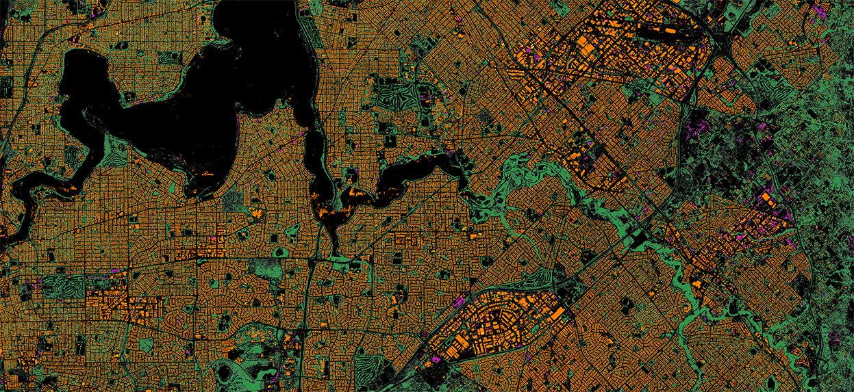
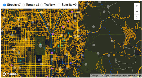


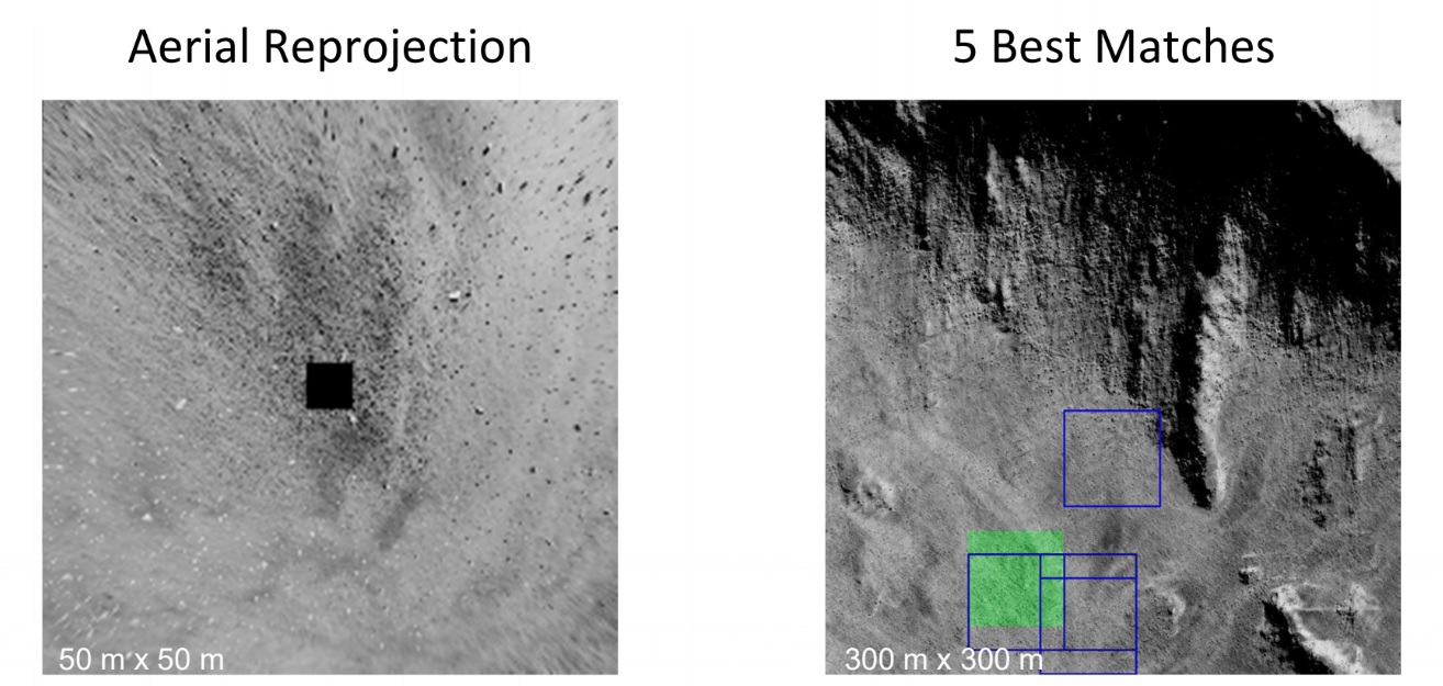


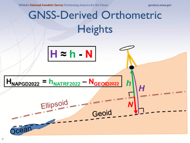


 Marianna Kantor joined Esri as chief marketing officer in 2015. Prior to Esri, Marianna was the VP of Marketing at PTC, where she built the worldwide services marketing and field-enablement organization, helping drive sustained revenue growth in dynamic and changing markets. Marianna has held technology and marketing leadership positions throughout her career in leading organizations such as AT&T, Akamai, and Los Alamos National Labs. At Esri, Marianna is exposing and amplifying the transformational capabilities of geospatial technology as an indispensable tool for problem solving and decision making in business and government. Marianna holds two engineering degrees from Columbia University and University of Pennsylvania, and an Executive MBA from MIT.
 As Esri’s chief technology officer, Jay Theodore guides the long-term vision for the ArcGIS platform. Jay is passionate about harnessing innovative ideas to increase the value companies gain from location intelligence, geoscience, computer science, and technology. He takes great pride in working with outstanding software developers, architects, and product engineers. Jay earned a master’s degree in computer science from Florida Institute of Technology, where his research focused on finite element analysis and modeling (FEA/FEM), computer graphics, and composite structure design for Space Station Freedom. He also holds a bachelor’s degree in computer engineering.