Quectel Wireless Solutions has launched the SG865W-WF, a new generation of flagship Android smart module. The module is equipped with Qualcomm’s QCS8250 system-on-chip (SoC), which offers powerful performance and rich multimedia functions to meet industrial and consumer artificial intelligence IoT (AIoT) scenarios.
Quectel made the announcement at the Consumer Electronics Show (CES) taking place this week in Las Vegas.
With various peripheral interfaces such as dual USB, multiple PCIe and UART, the product can seamlessly integrate with cellular and GNSS modules such as Quectel’s EC20 LTE module, and the RG500Q 5G module, allowing customer terminals to be connected flexibly to 4G/5G networks and achieve faster and more accurate positioning.
The SG865W-WF module will accelerate the efficient deployment of high-end AIoT applications such as video conferencing, cloud gaming, digital signage, unmanned aerial vehicles (UAVs), robots and smart retail.
“The tasks of paleontologists and classical historians and archaeologists are remarkably similar — to excavate, decipher and bring to life the tantalizing remnants of a time we will never see.” — Adrienne Mayor
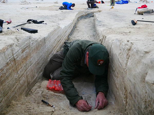
Heatwaves rose up from the dusty, dry, cracked ground. Tiny black flies buzzed around the team’s eyes and faces. The only shade was under a canopy erected across the shallow open trench where half a dozen people gently brushed away the layers. Dirt is time; the deeper one digs, the further back in time one goes.
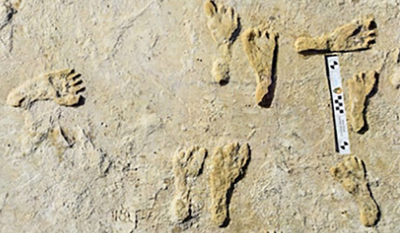
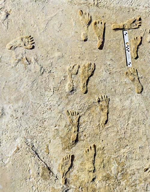
A layer 23,000 years old is exposed at nearly two feet down, revealing footprints of a female and a toddler. It tells a story of her mile-long journey through the soft clay mud. Roaming nearby was a giant sloth and a herd of mammoths. This discovery forces science to re-adjust the timeline of humans living on the North American continent, pushing it further back into the Pleistocene era at least 10,000 years.
Discoveries like this are the treasures archeologists seek. Archaeologists are scientists — part treasure hunters and part storytellers. They add context to history.
A trench dug into the brown gypsum soil on a lake playa in White Sands National Park reveals more human footprints below the surface. (Photo: National Park Service)
Ground-Penetrating Radar
Advanced technologies are aiding new discoveries of the past. Even though the footprints were buried beneath two feet of dirt, they were discovered without physically seeing them. Ground-penetrating radar (GPR) made the discovery possible. GPR has made significant advancements in recent years, along with improvements in other types of remote sensing applications.
The resolution of GPR has improved along with the depths that GPR can detect objects. Computers can process the GPR data into 3D images providing a depth profile of the scanned area. This is how the footprints were detected.
White Sands has the largest collection of fossilized human footprints. (Photo: National Park Service)
In addition to GPR, the researchers used magnetometers that verify disturbances in the sediment, which can also be imaged in 3D, albeit with a much lower resolution.
“The sediment itself has a memory that records the effects of the animal’s weight and momentum in a beautiful way. It gives us a way to understand the biomechanics of extinct fauna that we never had before,” said Thomas Urban, the Cornell University research scientist who led the team making the discovery.
Usually, archeological findings are of bones and artifacts. Fossilized “ghost” footprints of humans and other creatures brings them to life, providing glimpses of the living past.
Under ideal conditions, GPR can reach depths of 30 meters (98 feet). The accuracy and range of GPR depend on sediment type, moisture content and other geologic morphologies. Underlying GPR technology and magnetometry are robust geospatial information systems (GIS) that preserve a digital record of the discovery, allowing for further geospatial analyses. Advances in machine learning will improve future detection.
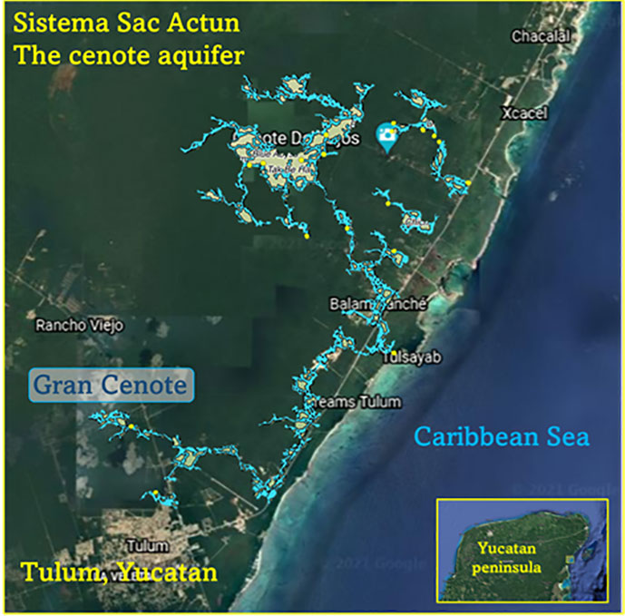
Elsewhere in the Americas, a project has been ongoing in Mexico since the 1990s using GPR to map the cenotes and underground aquifers used by the Mayans. A 215-mile-long underground water cave system — the longest in the world — has been mapped in the Yucatan peninsula. Divers exploring these cenotes found remains of Ice Age animals, including a sabertooth tigers and mammoths.
Map: William Tewelow
Lidar and ALS
Lidar (light detection and ranging) is making even more discoveries possible with the help of artificial intelligence and machine learning. For instance, in the jungles of Guatemala, lidar revealed the unknown ancient Mayan city of Tikal.
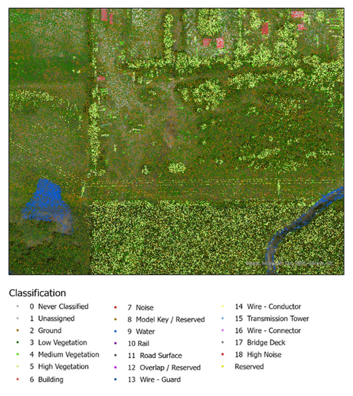
Lidar is an active sensor that measures ground height. Using an airborne laser scanning (ALS) system mounted to a plane, helicopter or UAV, the lidar device’s laser beams scan the landscape. The system calculates the time it takes for the beam to reach an object on the ground and bounce back.
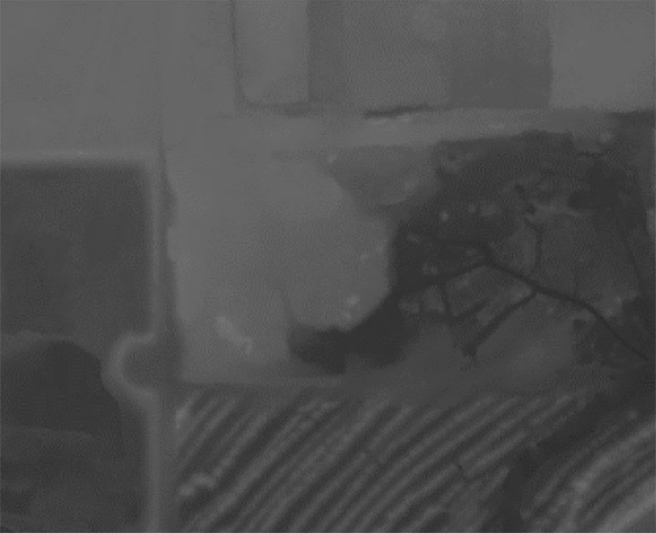
The result generates one point for each ground object the laser touches, calculating the distance the beam traveled. Billions of points are collected during a scan. Geospatial archeologists then process the collected points into a point cloud (Figure 1). Selecting only points classified as ground and water, the points are converted to a raster image, and archeologists are provided a perspective of the bare earth under tree canopy and vegetation (Figure 2).
In this way, lidar serves as a non-destructive way to identify earthwork formations, even in dense jungle.
Figure 2. Lidar points are converted to a raster providing a bare-earth representation of the landscape. (Image: Stephanie Clark)
Figure 3. Pixel-derived object-based classification, developed using machine learning, identifies unmarked headstones from UAV-collected imagery. (Image: Stephanie Clark)
Object-Based Imagery Analysis
The challenge with lidar and imagery is the sheer volume of data, beyond the scope of what a human can manually review. Because of how faint archaeological features can be, the search often requires manipulating imagery datasets by combining multispectral bands, and then merging them with topographical data. To assist this huge endeavor, artificial intelligence is applied to pixel-based classification and object-based imagery analysis (OBIA) to highlight areas of interest for further study.
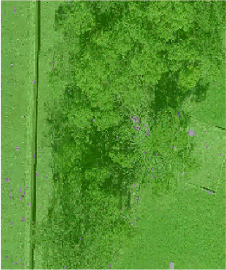
Dylan Davis, a Ph.D. candidate at Pennsylvania State University, spearheaded the use of OBIA for finding earthworks such as circular mounds, stone walls,and roadways in Beaufort, South Carolina. He took advantage of high-resolution NOAA imagery taken of the coast before the hurricane season of 2008. Using artificial intelligence for object-based imagery analysis, 160 previously undetected mound features were found.
Raster comparison: Sea Pines Shell Ring, Hilton Head Island, South Carolina. Credit: Dylan S. Davis, Matthew C. Sanger & Carl P. Lipo (2018): “Automated mound detection using lidar and object-based image analysis in Beaufort County, South Carolina,” Southeastern Archaeology [https://doi.org/10.1080/0734578X.2018.1482186]On the local level, archeologists apply the same approach to finding headstones in unmarked cemeteries. A pixel-defined object-based classification system helped one researcher automatically identify potential headstones in a densely vegetated cemetery.
The technology used for OBIA is also used for visual-inertial odometry (VIO). NASA is experimenting with VIO techniques to help astronauts navigate the lunar surface (see NASA’s Artemis program will need lunar spatial reference system). For Artemis, VIO will use the Moon’s craters as a reference system to derive an accurate position.
Virtual 3D Worlds
Perhaps one of the most significant uses of technology for archaeological research and exploration is the use of virtual 3D immersive worlds. Exploring ancient worlds as they might have looked gives archaeologists additional insights and the public a chance to experience their discoveries, connecting us with history.
The mile-long journey of a young female carrying a toddler across an Ice Age landscape 23,000 years ago seems so distant, yet so familiar to any parent. The image breathes life into our common ancestry. Through the power of GIS and modern technologies, she walked right into the 21st century.
“The man who knows and dwells in history adds a new dimension to his existence…He lives in all time; the ages are his, all live alike to him.” — William Flinders Petrie
Special thanks to Stephanie Clark, a geospatial archeologist with Integrated Environmental Solutions, LLC, of Phenix City, Alabama. Stephanie provided technical advice and collaboration, and the lidar studies for Figures 1, 2 and 3.
William Tewelow is a senior aeronautical information specialist for the Federal Aviation Administration. He is a 2016 graduate of the FAA’s management fellowship Program for Emerging Leaders and a mentor with the FAA’s National Mentor Program. He served on special assignment to the U.S. Department of Transportation and led a national strategic geospatial initiative under the authority of the White House Open Data Partnership.
Tewelow is a designated Geographic Information Systems Professionals (GISP), with degrees in geographic information technology and Intelligence Studies. he is currently earning his master’s degree in organizational leadership with a focus on performance management.
Tewelow retired from the U.S. Navy after serving 23 years as a geospatial and imagery intelligence specialist, a naval aviator, a meteorologist and a tactical oceanographer earning three achievement medals. He was among the first in the nation to earn a Geospatial Specialist Certification from the U.S. Department of Labor while working at NASA Stennis Space Center. He is married, enjoys traveling, connecting people, and solving problems, and is interested in new technology. His favorite quote is, “A man’s mind changed by a new idea can never go back to its original dimension.” ~ Oliver Wendell Holmes
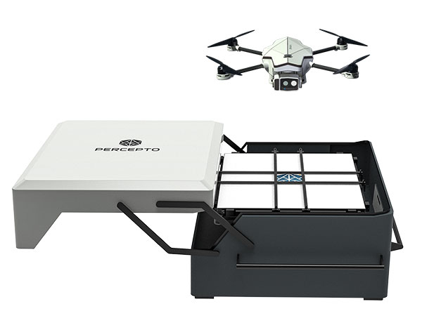
Percepto Air Mobile drone with base. (Photo: Percepto)
Percepto, an Israel-based company specializing in autonomous inspection with industrial robotics, has launched its 2022 Autonomous Inspection & Monitoring (AIM) platform and Air Mobile drone.
Recently listed in TIME magazine’s 100 Best Inventions of 2021, Percepto offers an end-to-end solution powered by artificial intelligence (AI) to collate and streamline all visual data for accurate actionable insights.
Percepto AIM 2022 has a new Insight Manager to deliver AI-powered packaged solutions for sector-specific use cases, such as solar, mining, energy, oil and gas and other industries. The company drew on tens of thousands of hours collected by autonomous robot missions at industrial facilities to create it.
Percepto’s AI change-detection framework offers unified visual data and critical business insights for each of the sector-specific solutions. AIM 2022 can be integrated with autonomous drones and robots as well as other visual data collectors, now including DJI drones, and fixed cameras.
Reports and insights are automatically generated based on the combined visual data. Disseminated to relevant stakeholders on any mobile device, issues and faults are geotagged and displayed on a map, enabling effective action before escalating into more serious problems.
Percepto also introduced its new Percepto Air portfolio to support the enhanced platform, which will address the diverse needs and increasing demands of various markets.
Percepto Air Max. The next generation of Percepto Sparrow, the Percepto Air Max is a field-proven solution that operates in the largest mining, oil and gas, and energy companies on six continents. It has a top-grade, versatile payload for specific use cases. Designed to inspect and map complex industrial environments where the highest accuracy and durability are critical, Air Max also has an optical gas imaging (OGI) camera.
Percepto Air Mobile. This option is a more compact and lighter weight model for smaller sites or organizations taking their first steps with a drone-in-the-box program, or larger sites that need greater deployment flexibility. It is designed for linear inspections, such as pipelines and power lines, and can monitor short-term projects across multiple sites, such as construction sites.
Percepto Air Max and Air Mobile drones are stored permanently onsite within their respective Percepto Bases. The Air Mobile’s base is light and easy to relocate while maintaining high levels of durability. These encasements are designed for infrequent maintenance and protection against extreme environmental phenomena, such as hurricanes. Percepto’s drones are safe and regulation ready, and ensure all operational aspects meet corporate standards.
“Percepto AIM 2022 and the new Percepto Air line of drones, together with the most advanced change detection solution, alert and prevent failures and downtime within diverse use cases across many industries,” said Percepto CEO Dor Abuhasira. “Percepto AIM provides the most advanced and comprehensive enterprise inspection software that offers a complete data workflow — from capture to insight. With Percepto Air Max and Percepto Air Mobile, companies have a range of options to choose from depending on the size of their facilities and the flexibility needed to deploy drones.”
“The real power of Percepto’s system is how data collection and analytics are integrated for a holistic view from both a technical and management perspective,” said Tim Shanfelt, director of Operations Transformation, Koch Ag & Energy. “Our workers are connected to high-level information that helps them make the right decisions while keeping them safe and free to pursue higher value activities. Our goal is to eliminate hazardous, wasteful, and mundane tasks from our operators’ day. For example, instead of an employee climbing an icy ladder in the winter, a robot or drone can perform the same task while still obtaining accurate measurements. We see Percepto playing a significant role in helping make our facilities more safe, secure, efficient, and profitable.”
Radar has been around since the late 19th century, but today it is poised to revolutionize how autonomous vehicles (AVs) navigate the road. From its nautical origins as a tool to detect the location of ships in heavy fog to being a cost-effective way to prevent collisions in self-driving cars, radar has a wide range of applications.
For more than 30 years, carmakers and drivers have embedded radar in vehicles to assist with automated cruise control, automatic emergency braking, parking, and more. This effective, hardy technology plays a critical role in the driver experience today, and the same hardware will be used to help AVs navigate the road soon.
I believe that the next chapter of radar use in vehicles will be in the AV market, where software powered by artificial intelligence (AI) will use radar sensors to read a vehicle’s surroundings and get riders safely to their destination.
Radar Is a Market-Proven Hardware Solution
Radar has been around for so long, and the sensors we rely on in our vehicles every day are so reliable, that most drivers are not even aware that they have radar to thank for the assist on their perfect parallel parking job.
In this era of auto innovation and smart tech, the benefits of turning to this proven hardware solution abound:
Radar can perform well in poor weather conditions.
It is cost-effective, especially when compared to lidar and camera-based options.
Thanks to its low power requirements, adding radar sensors does not significantly impact a vehicle’s energy budget.
It is market-proven hardware that is robust and reliable in the field.
While competing technologies such as lidar are still years away from demonstrating that they can stand up to weather conditions and the toll that mileage takes on equipment, there is no question that radar sensors are up for the challenges of the road.
The flip side of this coin is that we also have the benefit of knowing the limits of traditional radar technology: It has poor spatial resolution, limited sensitivity, and a narrow field of view. However, this hardware can be greatly enhanced with the right software boost.
An Oculii sensor placed at the front corner of a vehicle. (Photo: Oculii)
Unlocking the Potential of Radar with AI
Until recently, the best way to improve radar technology was to add more antennas until you got the resolution quality you were seeking. While this approach solves the problem of resolution, it introduces two other problems:
Adding antennas exponentially increases a radar’s complexity, power consumption and size, while only improving performance linearly.
In turn, this added complexity significantly increases the radar’s cost.
Consider the F-35 fighter jet, which relies on a radar system that costs more than the jet itself. While adding antennas may be a reasonable solution for military-operated airplanes, the consumer AV market would never tolerate the consequent cost increases. However, there is a way that existing automotive radars can be augmented with AI software to improve resolution, without increasing cost, size or power.
In the same way that AI software transformed what the automotive manufacturers were able to achieve with camera hardware, AI software can revolutionize how radar hardware is used for navigation in AVs.
Traditional radar sensors emit a constant, repetitive signal that delivers a reliable but low-resolution result. By using innovative AI software to emit an adaptive phase, modulated waveform that changes in real time, the resolution of traditional radar can be increased by up to 100 times. The key to transforming how we use radar hardware is all in the software.
street view of a driving car (center). At right, the same view is shown with high-resolution radar, with 400+ m of range with precise Doppler/point in all weather conditions. At left, is the view using a standard lidar camera, which has >100 m of range, no Doppler and weather limitations. (Image: Oculii)
Radar with AI
Reliable sensors with AI software can enable autonomous functions by augmenting the hardware that is already in today’s vehicles. What makes this solution so exciting is that it does not require a design overhaul: the smart sensors in question fit within existing radar packaging.
Augmenting radar hardware with AI can significantly improve performance while reducing the cost to the consumer. This formula — better performance at a lower price tag — has the potential to greatly accelerate the speed with which AVs make it safely to the consumer market and to revolutionize the automotive industry.
Rather than pushing forward with the development of costly alternatives that are prohibitively expensive for the consumer market, intelligent radar sensors can bring AVs to the road sooner and for more drivers.
Steven Hong is the founder and CEO of Oculii, a high-resolution radar company enabling the next generation of autonomous systems. Powered by AI, Oculii software increases the resolution of commodity radar hardware by up to 100 times and works in any environment.
Hexagon AB has acquired CADLM SAS, a company focused on computer-aided engineering (CAE) with artificial intelligence (AI) and machine learning. These technologies enable simulation in product-development processes and lifecycles.
Founded in 1989, France-based CADLM develops computational design and optimization methods for industrial products and processes. Since 2014, CADLM has been developing AI and machine learning solutions. Its ODYSSEE software platform applies AI and machine learning to real-world sensor data and physics-based simulation data to produce accurate, predictive models of a product at efficient computing power levels.
The combination enables faster, more efficient simulations of dynamic, multi-physics phenomena — such as automotive crash and safety — that fully characterize and understand real-world product behavior. This insight enables engineers to explore the design more extensively and interactively, and improve next-generation products without prohibitive computing cost or time.
Ola Rollén, CEO, Hexagon
Use of the digital twin beyond the early design phase enables manufacturers to leverage image recognition, predictive simulation and fault prediction to address challenges such as downtime, throughput, quality and flexibility throughout the manufacturing process.
“The convergence of CAE with advances in data management, AI, machine-learning and an increasingly connected manufacturing lifecycle is transforming the industry’s ability to address increasingly complex design challenges with rapid innovation and increased productivity,” said Hexagon President and CEO Ola Rollén. “CADLM’s AI knowledge and technology further strengthen our smart manufacturing solutions portfolio, putting data to work beyond the early design phase to improve product design innovation, manufacturing productivity, product quality and environmental sustainability through reductions in material waste.”
CADLM will operate as part of Hexagon’s Manufacturing Intelligence division. The acquisition has no significant impact on Hexagon’s earnings. Completion of the transaction (closing) is subject to normal closing conditions.
Release follows $1 billion Innovyze acquisition announcement by Autodesk
Water infrastructure software company Innovyze has released Info360.com, a cloud-based, artificial intelligence-powered platform for real-world water lifecycle management.
Combined with Info360 Insight, a data visualization and workflow solution, the platform enables dynamic digital twins for the water industry.
Dynamic Digital Twins are virtual models of real-world assets and systems that can learn and adapt to changing circumstances. Built upon Amazon Web Services (AWS), Info360.com is uniquely designed to support Dynamic Digital Twins by gathering and unifying asset information, connecting live and historic performance data to Innovyze as well as third-party applications.
Autodesk Inc. announced March 1 it signed a definitive agreement to acquire Portland, Oregon-based Innovyze for $1 billion net of cash subject to working capital and tax closing adjustments. Autodesk’s digital-twin strategy creates a clearer path to a more sustainable and digitized water industry, the company said.
This context-aware platform can predict future performance using synchronized computational models that become more intelligent as they’re used. Info360.com provides recommended best-case actions that can help water utilities maintain the highest levels of service, capacity and efficiency.
Due to water system complexity and static operating budgets, many water utilities have struggled to adopt the digital transformation technologies that would allow them to improve predictability and performance. Using the power of the cloud, Info360.com is financially and operationally more accessible, powerful and flexible than traditional on-premise systems.
“The complex, physical properties of water and massive, underground infrastructure that must be monitored and managed make digitization extremely challenging for water utilities,” said Colby Manwaring, Chief Executive Officer at Innovyze. “We’ve combined 35 years of expertise in water management with the power of the cloud to bridge the data and technology gaps that have kept water utilities from truly capitalizing on Digital Twins with our new Info360.com platform. This is a game-changer in making digital transformation achievable for water utilities of any size.”
The new Info360 Insight SaaS application provides utilities with customizable dashboards and KPIs that track and visualize the real-time performance of the entire water distribution system. Performance data can be used and analyzed for daily operations, such as pipe break detection and water loss. The same data can also be used to plan for future maintenance and capacity fluctuations, with seamless integration into the hydraulic model.
“Info360 Insight is the first of several SaaS applications we’re delivering for the Info360.com platform, all offering advantages to utilities like easy onboarding, infinite scalability, and rigorous security out of the box,” said Rick Gruenhagen, CTO at Innovyze. “Better yet, the Info360 platform architecture incorporates cutting-edge technologies like predictive analytics and artificial intelligence tuned specifically for the water lifecycle, allowing utilities of all sizes to stay at the forefront of innovation without the need to maintain complex software or hire hordes of IT experts. As a result, utilities will have the technology foundation they need to deliver the highest possible service at the lowest possible cost.”
Info360 Insight provides real-time ingestion and analysis of SCADA data, along with 24/7 event monitoring, enabling utilities to detect incidents within their infrastructure. The system can check multiple resolution scenarios and apply recommended actions to resolve the failure as quickly as possible — ensuring a higher level of service and reliability.
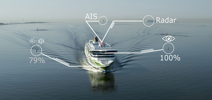
A day of ferry trips between Finland and Estonia became some of the best documented voyages in maritime history. Cameras, sensors, radio and satellite navigation receivers and even microphones recorded every instant of the crossings over the Baltic, gathering raw data for a new ESA-led project applying artificial intelligence (AI) to the situational awareness of shipping — as an important step to full autonomy.
The Tallink shipping company’s new 212.2 meter-long Megastar passenger and car ferry was fitted with data-gathering devices for its sailings on the busy stretch of sea between Helsinki and Tallinn.
The testing was overseen by a team from the Finnish Geospatial Research Institute (FGI) for an ESA project called Artificial Intelligence/Machine Learning Sensor Fusion for Autonomous Vessel Navigation, or Maritime AI-NAV.
“Our aim is to show how AI can be applied to achieve autonomous situational awareness, so that a ship can reliably sense its own environment,” said FGI’s Sarang Thombre.
Photo: European Space Agency
“Such autonomous systems would initially be deployed in support of human crews, for enhanced safety and efficiency – with crewless ships a much longer-term goal.
“The most experienced human ship captains will have the least trust in any single navigational device but will rather continuously cross reference between them. Similarly, our autonomous functionality will not be overly reliant on a single data source but combine and verify data from multiple sensors.
“Having gathered many gigabytes of data during our initial August field campaign, then again in October with more days planned in December, we are applying the results to train and test our data-fusing algorithms. A follow-up seagoing test will then verify their performance in practice.”
The Maritime AI-NAV team plans to employ a variety of sensor types, including satellite navigation receivers – also utilizing of Europe’s Galileo system — monocular and stereo cameras, standard radar, “laser radar” lidar and an array of microphones, along with “Automatic Identification System” radio signals. These AIS signals transmit position, size and routing information of all vessels above a certain class, as well as fixed infrastructure such as oil rigs or wind turbines.
“Satellite navigation lets the ship know where it is in the sea, while the other sensors let it know what is around it, which is essential for identifying and avoiding any obstacles,” Thombre said. “The different data sources operate across a variety of ranges — so radar and AIS provide longer range detection out to the horizon, while cameras and lidars come into their own at shorter distances. Plus we had a trio of microphones aboard the Megastar, determining the angle of arrival of sound from other ships. The challenge now is to fully integrate all these sources using machine learning, to build up a holistic picture.”
Maritime AI-NAV is supported through ESA’s Navigation Innovation and Support Programme, working with European industry and academia to develop innovative navigation technology.
FGI is joined in the Maritime AI-NAV consortium by Aalto University’s Sensor Informatics and Medical Technology group and maritime IT startup Fleetrange.
Advances in geospatial technology have opened up many new possibilities in areas such as national security, urban planning and emergency preparedness. When I was embedded with the U.S. Army as a scientist in Afghanistan, I got to experience firsthand the exceptional value of 3D data. The military used nation-scale imagery and lidar to generate 3D maps that then informed their safety-critical operations. However, since lidar—like most three-dimensional unstructured data—contains incredible complexity and detail, it was painfully slow to analyze manually.
As a result, the impact of this technology was severely restricted by speed and cost due to the significant manual effort required to extract actionable insights. As we looked to the future, where lidar would become commonplace in consumer electronics and automobiles, it became clear that there was an opportunity to combine computer vision/AI with large-scale cloud computing to rapidly and automatically generate actionable insights from 3D data.
Screenshot: Enview
After returning from Afghanistan, I reconnected with Krassimir Piperkov, a former colleague from ICON Aircraft, and fellow Stanford alum, to launch Enview. Our objective was to automate 3D geospatial analytics and create a living 3D model of the world to help organizations to protect their critical infrastructure and communities.
Powering geospatial data with AI can take the limits off 3D data analytics, prevent threats from becoming incidents, and protect critical infrastructure. What used to take days or months to process can now be done in minutes, enabling analysts, operators, and decision-makers across the public sector to make timely and accurate decisions. By enhancing our understanding of the physical world, this technology empowers us to tackle pressing challenges like wildfire prevention, humanitarian assistance, disaster response, and more.
Let’s take a look at how AI-powered 3D modeling is being put to use.
Digital twins
A living 3D model of the world, or a digital twin, can be used for many purposes. Enview’s software fuses many different data sets together to create digital twins that are global in scale but have high-resolution to enable local decision-making. These digital twins include 3D terrain, vegetation, buildings, and infrastructure such as power lines, roads, and water works. Enview also fuses real-time and forecasted conditions, such as wind, temperature, humidity, traffic, and IoT (internet of things).
This sort of rich representation of the physical world is an incredibly complex big data challenge. Data comes from radically different sensor modalities, with different resolutions, formats, time-domains, and accuracy. AI plays a critical role in automating the fusion of these datasets, by helping to intelligently align and then fuse them into a cohesive entity. 3D geospatial data is particularly challenging, as it is unstructured data, which requires a new generation of deep learning frameworks whose convolutional kernels are specifically developed from the ground up to work on unstructured data. Further, the datasets are massive in scale. A square-mile of 3D lidar data can have hundreds of millions of points; the magnitude of the data easily passes the petabyte scale when one considers applications that span nation-scale areas. In order to process this volume of data, modern geospatial AI architectures must be containerized and dynamically deployable across cloud compute resources to generate timely insights.
AI is essential to help human experts to extract meaningful insight from this overabundance of data. The application of automated workflows allows experts to look at larger areas, with more speed and higher frequencies. This machine-assisted cognition draws upon the respective strengths of people and computers to do what neither could do on their own.
Humanitarian aid and disaster relief
3D models can be built to monitor hurricane hotspots, such as the Gulf Coast, before major storms strike. By layering in real-time weather information such as rainfall, winds, and flooding, these models can help with planning, emergency response, and relief efforts.
This data also provides life-saving insight that can assess damage to buildings, transportation, and downed power lines, in addition to determining where to send medical and relief supplies, and how to best get them there. 3D data can help to lessen the impact of future weather events by updating the baseline understanding of how storms impact coastal communities so they can plan for the future.
Screenshot: Enview
Infrastructure protection
Inadequate clearances between vegetation and power lines can result in wildfires and unplanned power outages. Many federal, state, and local regulations are in place to mandate clearances, and power line operators monitor their networks continuously to ensure that they abide by these regulations and prevent incidents and outages. However, doing so by walking or flying the lines and judging distances with the human eye is challenging and inaccurate.
The ability to identify the exact location and clearances of high-risk vegetation early, and at scale, lets operators identify, prioritize, and address problem areas proactively. Lidar-driven programs have helped with risk-reduction, but are constrained by the massive levels of manual data manipulation required to derive insights from this 3D data. The automation of 3D geospatial analytics through AI, machine vision, and parallel computing enables the accurate and rapid identification of at-risk areas, protecting critical infrastructure and communities.
Screenshot: Enview
Fighting wildfires
Devastating wildfires resulting in the loss of life and property have become commonplace in the western U.S. and other parts of the world. The tools and methods previously relied on to keep communities and infrastructure safe are now struggling to keep up with this increased threat.
Geospatial information, including 3D data, provides a digital view of the physical world and, when paired with AI, gives stakeholders the informational edge they need to minimize wildfire damage, injuries, and deaths. This technology can be used to automatically build and update real-time, high-resolution wildfire risk maps that give firefighters and communities more notice when threats are imminent, and provide firefighters with real-time situational awareness when they’re fighting the blazes.
Change detection
According to the Pipeline and Hazardous Materials Safety Administration (PHSMA), third-party excavations are one of the leading causes of pipeline incidents in the U.S. These incidents can lead to service disruptions, expensive repairs, and sometimes serious injuries or deaths.
Detecting signs of excavation or earth movement via aerial patrolling is challenging and costly, while resource limitations make it difficult for pipeline operators to continuously monitor remote areas such as farms. AI-powered 3D maps can be used to monitor topography and accurately detect changes that threaten pipelines in real time.
3D data provides remarkable value when it comes to decision-making as it relates to many different applications—from military defense to protecting neighborhoods from wildfires. However, its success hinges on one thing: speed. The ability to process 3D geospatial data rapidly, and at scale, is made possible through advances in AI and cloud computing. In the future, we can expect to see more exciting and innovative use cases for AI-powered geospatial technology.
San Gunawardana is co-founder and CEO of Enview, a geospatial analytics company. After finishing a Ph.D. in aerospace engineering at Stanford, Gunawardana went to Afghanistan, where he combined data analytics and remote sensing to detect threats and prevent incidents. He is excited to apply those insights to help the energy sector solve problems. He has done computer vision at NASA, built imaging satellites with the Air Force, and was an early employee at ICON Aircraft.
SPH Engineering has partnered with Daewoo Engineering and Construction (E&C). Through the partnership, SPH will support Daewoo’s data management projects through its Atlas artificial intelligence (AI) platform, which enables aerial imagery storage, map creation, change tracking, object detection and territory segmentation.
Photogrammetry data is expected to become one of the key components for storage and processing, SPH added.
According to the companies, Atlas will enable Daewoo Engineering and Construction to set up an online archive of drone imagery and photogrammetry products, track changes and generate reports, automate object detection and measure the identified objects of interest. The platform also will increase data availability for participants of construction workflow.
“Atlas can be definitely used in various fields, but it will be a groundbreaking platform, especially in the field of construction survey,” said Geunmok Song (Alex), digital construction team manager at Daewoo Engineering and Construction.
“When we introduced Atlas back in spring, first of all we wanted to support our existing UgCS customers with an easy-to-use AI tool to store and process data collected with our software integrated to a UAV,” said Alexei Yankelevich, R&D director at SPH Engineering. “We are proud that Daewoo Engineering and Construction, the representative of Korea, has opted for our solution.”
L3Harris Technologies will help the U.S. Department of Defense (DOD) develop artificial intelligence and machine learning (AI/ML) systems to help reduce the amount of time it takes to decipher usable intelligence from increasing amounts of data collected from space and airborne assets.
L3Harris will research, develop and demonstrate an AI/ML interface using data science techniques under a new multimillion-dollar contract to support DOD applications.
“L3Harris’ work will allow the DOD to turn massive volumes of data into actionable intelligence,” said Ed Zoiss, president, Space and Airborne Systems, L3Harris. “The abundance of data collected by space and airborne assets is only increasing. The findings of this research will directly address the data processing challenges within the DOD and intelligence community.”
Awarded by the U.S. Army Research Laboratory, the contract supports the DOD’s initiative to accelerate the integration of big data and AI/ML within the agency.
L3Harris will perform the work in Rochester, New York; Melbourne, Florida; and Herndon, Virginia.
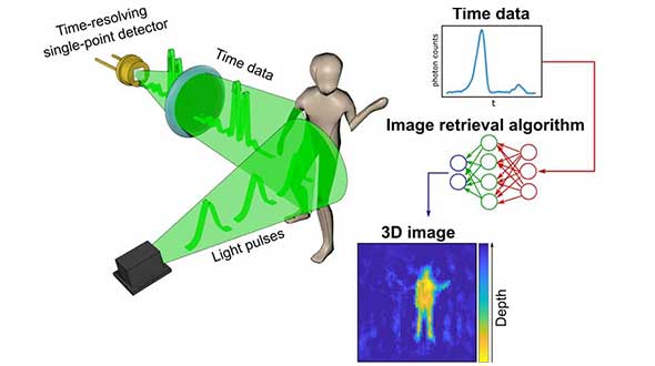
A new method of imaging that harnesses artificial intelligence to turn time into visions of 3D space could help cars, mobile devices and health monitors develop 360-degree awareness.
Photos and videos are usually produced by capturing photons with digital sensors. 3D images can be generated either by positioning two or more cameras around the subject to photograph it from multiple angles, or by using streams of photons to scan the scene and reconstruct it in three dimensions. Either way, an image is only built if spatial information of the scene is gathered.
Now, researchers based in the United Kingdom, Italy and the Netherlands describe how they have found an entirely new way to make animated 3D images — by capturing temporal information about photons instead of their spatial coordinates. The team’s paper, “Spatial images from temporal data,” was published in Optica.
Their process begins with a simple, inexpensive single-point detector tuned to act as a kind of stopwatch for photons. Unlike cameras, which measure the spatial distribution of color and intensity, the detector only records how long it takes the photons produced by the split-second flash of a pulse of laser light to bounce off each object in any given scene and reach the sensor. The farther away an object is, the longer it will take each reflected photon to reach the sensor.
The information about the timings of each photon reflected in the scene — temporal data — is collected in a simple histogram. Those graphs are then turned into a 3D image using a sophisticated neural network algorithm. The researchers “trained” the algorithm by showing it thousands of conventional photos of the team moving and carrying objects around the lab, alongside temporal data captured by the single-point detector at the same time. Eventually, the network learned enough about how the temporal data corresponded with the photos that it was capable of creating highly accurate images from the temporal data alone.
In the proof-of-principle experiments, the team managed to construct moving images at about 10 frames per second from the temporal data, although the hardware and algorithm used has the potential to produce thousands of images per second.
Alex Turpin, a Lord Kelvin Adam Smith Fellow in Data Science at the University of Glasgow’s School of Computing Science, led the university research team with Prof. Daniele Faccio and support from colleagues at the Polytechnic University of Milan and Delft University of Technology.
“Cameras in our cellphones form an image by using millions of pixels,” explained Turpin. “Creating images with a single pixel alone is impossible if we only consider spatial information, as a single-point detector has none. However, such a detector can still provide valuable information about time. What we’ve managed to do is find a new way to turn one-dimensional data — a simple measurement of time — into a moving image that represents the three dimensions of space in any given scene.”
After data collection, 3D images are retrieved from the temporal histograms. (Image: University of Glasgow)
The approach is capable of decoupling light altogether from the image-capture process, and the paper discusses how the team managed to use radar waves for the same purpose. “We’re confident that the method can be adapted to any system which is capable of probing a scene with short pulses and precisely measuring the return ‘echo.’”
Right now, the neural net’s ability to create images is limited to what it has been trained to pick out from the temporal data of scenes created by the researchers. But with further training and by using more advanced algorithms, it could learn to visualize a range of scenes, widening its potential applications in real-world situations.
“The single-point detectors that collect the temporal data are small, light and inexpensive, which means they could be easily added to existing systems like the cameras in autonomous vehicles to increase the accuracy and speed of their pathfinding,” Turpin said. “Alternatively, they could augment existing sensors in mobile devices like the Google Pixel 4, which already has a simple gesture-recognition system based on radar technology. Future generations of our technology might even be used to monitor the rise and fall of a patient’s chest in a hospital to alert staff to changes in their breathing, or to keep track of their movements to ensure their safety in a data-compliant way.”
Next, the team will work on a self-contained, portable system-in-a-box as well as examining options for furthering research with input from commercial partners. The research was funded by the Royal Academy of Engineering, the Alexander von Humboldt Stiftung, the Engineering and Physical Sciences Research Council (ESPRC) and Amazon.
Citation. A. Turpin, G. Musarra, V. Kapitany, F. Tonolini, A. Lyons, I. Starshynov, F. Villa, E. Conca, F. Fioranelli, R. Murray-Smith, and D. Faccio, “Spatial images from temporal data,” Optica 7, 900-905 (2020), https://doi.org/10.1364/OPTICA.392465.
GNSS receivers first reached the commercial domain in the early 1980s. They were bigger than your average carry-on suitcase, weighed more, and consumed so much power that they needed to be plugged into an outlet. But technology advanced quickly, and by the mid-1980s commercial GNSS receivers were appearing in survey and marine markets.
Generation 1. The first generation of truly mobile receivers, in the late 1990s, used only L1 C/A code and were typically found in rugged handhelds for outdoor enthusiasts. The receivers began appearing in mobile phones in the late 1990s.
Gen 2. The second generation added GLONASS. These receivers had to have wider bandwidths on the order of 20-30 MHz to support the GLONASS FDMA signals at a slightly offset frequency from GPS L1.
Gen 3. These receivers added support for Galileo. They started appearing in mainstream cellphones in about 2014. These phones still retained a single frequency front end in the L1 band, but had separate digital processing chains for all three satellite systems.
Gen 4. This evolution added support for BeiDou and a single sideband L5 receiver where BeiDou, Galileo and GPS all have modernized signals. These receivers first appeared in phones in 2019 because of the added size, power and complexity of supporting a dual-band receiver. The front end is a burden on many phone models, especially with the rise of 5G. Plus, the L1 band has reliability issues with jamming and interference. The receivers only support a single sideband at L5 and are not utilizing the full capability of L5.
Every GNSS user in every segment benefits from using the new, modernized signals in the L5 band. L5 signals are more accurate, reliable and available in sufficient numbers to support all user segments. Here are the major advantages of L5 over L1.
Signal structure (narrow correlation peak) accuracy
Wide bandwidth (multipath mitigation) accuracy
Pilot codes (longer coherent integration increasing SNR)
Multiple constellations and signals with common signal structure
Stronger signal transmission
Cleaner band with less interference
Signal availability
The benefits of L5 are clear. That’s why many GNSS suppliers have started building L1/L5 solutions, and they are starting to appear in smartphones. It seems to be a natural progression to add an L5 receiver chain on top of an existing L1 solution and be able to reap the benefits. But bringing along the legacy L1 solution could actually have a negative impact on the overall solution.
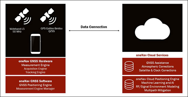
The oneNav L5 mobile GNSS system architecture. (Image: oneNav)
L5 Wideband Receiver
We set out to build a fifth-generation GNSS receiver for mobile consumer products. Its single-frequency design only uses the modernized, wideband signals at L5. It has an acquisition engine sophisticated enough to acquire L5 signals directly and a navigation engine that uses artificial intelligence/machine learning (AI/ML) techniques to fully exploit all the signals in 50-MHz wideband at L5.
Optimized engine. Building an acquisition engine for the L5 signal is a huge mathematical task. Since the codes are 10 times longer and have a 10 times faster chipping rate, it’s a 100 times more difficult search problem. The oneNav engine solves that problem with a customized array processor that has a GPU-like approach, maintaining TTFF.
Single-frequency architecture. Pure L5 architecture eliminates the need for a second RF chain. The oneNav L5 engine uses common hardware for signals from all GNSS systems.
Increased sensitivity. The L5 signal has a modernized signal structure that allows for increased sensitivity for both acquisition and tracking. With wideband architecture, all parts of the L5 signal can be combined for maximum performance and significantly more signal strength than L1.
Improved time to fix. Dual-band receivers first get a fix on L1 and then begin the acquisition process on L5. By performing the L5 acquisition directly, we save time.
Acquisition reliability. The L1 signal structures do not have the longer primary codes and the secondary codes like modernized signals on L5 that mitigate many of the reliability problems associated with cross correlation, jamming and spoofing.
Improved tracking and measurement. Using the full bandwidth allows a more sophisticated channel estimation than a simple pseudorange measurement. With multiple signals contained within the L5 wideband signal, we gain advantages from channel diversity.
AI/ML navigation engine. A cloud-connected navigation engine uses advanced AI/ML techniques to further improve navigation accuracy. Sophisticated ML techniques to predict if the received signal is line of sight and predict the measurement error caused by multipath. The cloud service allows reflected signals to be used correctly in the navigation solution rather than being excluded due to their multipath content. A sophisticated pattern-matching-based positioning algorithm combines the pseudorange measurements and the environment’s 3D building map model to enhance positioning accuracy in deep urban canyons.
IP Core
We designed the oneNav receiver as a licensable IP core rather than a discrete silicon solution. The complete solution includes all the firmware and an RF front-end reference design from antenna to A/D converter. This allows customers to determine how to best bring the oneNav advantages to their products.
The IP core can be integrated into a larger ASIC such as a modem or an SOC. It could also be implemented as a discrete silicon solution. The RF could be combined into any of these solutions or implemented with other RF components in the system. The measurement and position engine firmware can be run on a dedicated CPU or shared in either the same or different CPUs for flexible system integration optimal for various applications. The IP core is both process independent and scalable. An integrated GNSS core means that GNSS performance can be maintained across multiple platforms and silicon generations, providing consistency of measurement and positioning performance needed to maintain system reliability and fusion.
In my opinion, the Pure L5 wideband receiver can be considered a next generation — or fifth generation — of GNSS for mobile consumer products.

![<b>Raster comparison: Sea Pines Shell Ring, Hilton Head Island, South Carolina. </b>Credit: Dylan S. Davis, Matthew C. Sanger & Carl P. Lipo (2018): Automated mound detection using lidar and object-based image analysis in Beaufort County, South Carolina, Southeastern Archaeology [https://doi.org/10.1080/0734578X.2018.1482186]](https://stage.globalpositioningnews.com/wp-content/uploads/2021/11/Davis-SC-mounds-HiltonHead.jpg)