Tag: artificial intelligence

  • New autonomous Mayflower launches from Plymouth to gather ocean data

    New autonomous Mayflower launches from Plymouth to gather ocean data

    Photo: Tom Barnes for IBM
    Photo: Tom Barnes for IBM

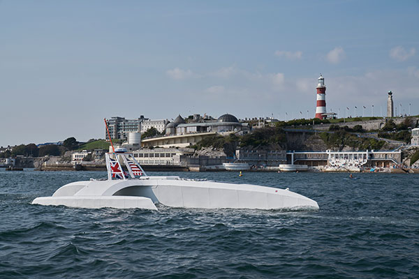
    An autonomous ship launched Sept. 16 on a mission to traverse oceans and gather vital environmental data, guided by GNSS and inertial measurement units (IMUs).

    Ocean research non-profit ProMare joined with IBM on the Mayflower Autonomous Ship (MAS) — an artificial intelligence (AI) and solar-powered marine research vessel. Following two years of design, construction and training of its AI models, the fully-autonomous trimaran was launched from Plymouth, England.

    The ship is guided by both GNSS and IMU technology. It uses two Hexagon | Veripos LD8 receivers, each with two V560 marine antennas. The onboard IMUs include an iXBlue Octans and two Silicon Sensing AMU30s.

    Designed to provide a safe, flexible and cost-effective way of gathering data about the ocean, the new-generation Mayflower promises to transform oceanography by working in tandem with scientists and other autonomous vessels to help understand critical issues such as global warming, micro-plastic pollution and marine mammal conservation.

    ProMare is coordinating the scientific studie,s working with IBM Research and leading scientific organizations.

    MAS features an AI captain built by ProMare and IBM developers that gives MAS the ability to sense, think and make decisions at sea with no human captain or onboard crew. The new class of marine AI is underpinned by IBM’s latest advanced edge computing systems, automation software, computer vision technology and Red Hat Open Source software.

    “Able to scan the horizon for possible hazards, make informed decisions and change its course based on a fusion of live data, the Mayflower Autonomous Ship has more in common with a modern bank than its 17th century namesake,” said Andy Stanford-Clark, Chief Technology Officer, IBM UK & Ireland. “With its ability to keep running in the face of the most challenging conditions, this small ship is a microcosm for every aspiring 21st century business.”

    Photo:
    Artie — short for Artemis and artificial Intelligence — is a stowaway hitching a ride on the Mayflower who answers questions about the ship, the ocean or himself on mas400.com. (Photo: IBM)

    Interactive web portal follows voyage

    To enable followers around the world to stay updated with MAS as it undertakes its various missions, IBM and ProMare have also launched an interactive web portal. Built by IBM iX (the business design arm of IBM Services), the MAS400 portal is designed to provide real-time updates about the ship’s location, environmental conditions and data from its various research projects.

    Live weather data is streamed from IBM’s The Weather Company, as MAS receives forecast data and insight from the new IBM Weather Operations Center.

    ‘Octopus’ aboard answers questions

    The portal even features a seven-armed, stowaway octopus chatbot called Artie, who claims to be hitching a ride on the ship. (With seven arms, he’s technically a septopus.) Powered by IBM Watson Assistant technology and created in partnership with European startup Chatbotbay, Artie has been trained to provide information about MAS and its adventures in a lively, and accessible format.

    “MAS400.com is one of the most advanced ocean mission web portals ever built,” says Fredrik Soreide, Scientific Director of the Mayflower Autonomous Ship project and Board Member of ProMare. “Protecting the ocean depends on our ability to engage the public in important matters affecting its health. This MAS400 portal is designed to do exactly that and tell people where the ship is, what speed it’s travelling at, what conditions it’s operating in and what science we are conducting. Users can even help Artie the Octopus fish out surgical masks, cigarette butts and other increasingly common forms of ocean litter from a virtual ocean of facts and data.”

    MAS will spend the next six months in sea trials and undertake various research missions and voyages before attempting to cross the Atlantic in Spring 2021. MAS’s transatlantic voyage will be based on a similar route and pioneering spirit to the 1620 Mayflower which made the same crossing 400 years ago.

  • Hexagon selected for Innovate UK rail infrastructure artificial intelligence project

    Hexagon selected for Innovate UK rail infrastructure artificial intelligence project

    Innovate UK, the United Kingdom’s innovation agency, has selected Hexagon’s Geospatial division to conduct a research project that will result in faster and higher-precision mapping of railway infrastructure through the use of artificial intelligence.

    The project is funded by Network Rail, the owner and operator of Great Britain’s railway infrastructure, under its R&D portfolio and delivered by Innovate UK through the SBRI competition, Innovation in Automated Survey Processing for Railway Structure Gauging, Phase One. A small group of teams was selected for this effort.

    Image: Hexagon
    Image: Hexagon

    The project will enable Network Rail to automatically identify and measure railway structures from lidar data, saving valuable time and resources, while also improving planning and operations across the rail network. The current, manual process takes analysts months or even years due to the size of the data and the labor-intensive tasks involved.

    “The combination of cross-sectional area, shape, length and speed all place a space requirement on today’s railway,” said James Sweeney, senior engineer at Network Rail. “We anticipate this project will offer us a more efficient way to capture, analyse and measure railway features along 20,000 miles of track, which is important to railway safety and the growth and capacity of our network.”

    Network Rail collects detailed information about its track and the surrounding features, such as bridges and tunnels. The data is then analyzed to assess clearances between trains and the infrastructure around them, which is key to safety.

    Image: Hexagon
    Image: Hexagon

    The new project aims to automate the extraction and calculation of railway features from sensor data, leveraging AI to automatically analyze point-cloud data, identify different structure types, and perform measurements on the structures. The data will be collected from reality capture solutions from Hexagon’s Geosystems division.

    “Network Rail, supported by Innovate UK, is leading the way in the use of AI to automate rail structure identification and measurement,” said Mladen Stojic, president of Hexagon’s Geospatial division. “We are excited to be part of a project that can help transform the gauging process for UK railways.”

  • AI and intuitive cameras pave way for future of aerial imaging

    Photo: pics721/iStock/Getty Images Plus/Getty Images
    Photo: pics721/iStock/Getty Images Plus/Getty Images

    Advancements in sensors, cameras and automation have fueled the growth of the aerial imaging industry, which is expected to reach $2.83 billion by 2022.

    By Swamini Kulkarni

    Unmanned aerial vehicles (UAV), or drones, often gain the spotlight with to their ability to capture the view from a vantage point. For years, airborne cameras have clicked never-seen-before pictures across planet. Now imaging technology is utilized to monitor natural calamities and borders of countries.

    Drones have been quickly adopted in various industries including surveillance, geospatial mapping, post-disaster monitoring, and even entertainment. The advancements in sensors, cameras and automation have fueled growth of the aerial imaging industry.

    Cameras mounted on balloons, kites and now drones are used widely across various verticals such as government, agriculture, civil engineering and research. Surveillance through satellite imagery has challenges, many of which drones can overcome. Drones can be used whenever we want and can be equipped with lidar systems, geographic information systems and advanced cameras. This has created lucrative opportunities in the aerial imaging industry.

    According to Allied Market Research, the global aerial imaging market is expected to reach $2.83 billion by 2022, growing at a CAGR of 12.9% from 2016 to 2022. The launch of novel and intuitive cameras has further increased the popularity of aerial imaging.

    Advent of novel, intuitive cameras for aerial imaging

    AirSelfie, a prime market player in the aerial imaging industry, launched AIR PIX aerial camera at Consumer Technology Association (CES) 2020. The company announced that it has started shipping AIR PIX+ to customers the world’s smallest pocket-sized aerial camera. Moreover, it declared that it would make available AIR DUO, the aerial camera equipped with the dual parallel camera later in 2020. Both of these cameras offer state-of-the-art technology and would prove to be vital in aerial imaging and capturing videos from the air.

    Skydio, the leading U.S. manufacturer of drones and autonomous flight technology, recently launched new software solutions and autonomous drone platform for situational awareness and inspection. It is observed that despite the potential drones showcase in aerial imaging, its adoption is still limited due to concerns regarding the risk of crashes of autonomous drones.

    Moreover, the requirement to hire experienced pilots and data security concerns prevent firms from scaling their aerial imaging programs. That’s why Skydio aims to unlock the potential through this autonomy software and change people’s perspective toward drones.

    In addition, the company has partnered with Eagleview, a leader in aerial imagery industry and data analytics to empower home insurance agents to offer accurate inspection of residential homes without the use of expert drone pilots. This technology is expected to be available in the fourth quarter of 2020.

    Artificial intelligence: Future of aerial imaging

    Today, every industry is searching for ways to operate devices remotely or at least with minimum physical contact. With the experience of global pandemic keeping in mind, the future is clearly bright for autonomous drones.

    Several industries, including aerial imaging, rely on advancements in autonomous UAVs. Moreover, the success of aerial imaging depends on both autonomous drones and carefully dealing with the data gathered by aerial cameras. This is where artificial intelligence (AI) comes into the picture.

    For use of aerial imaging for property surveillance, there is a dire need for a solution that can streamline data analysis, make sense of the data gathered by cameras, and scale up the level of details offered by aerial imaging.

    AI-based aerial imaging can be used for automated property analytics and streamline facilitation of risk underwriting and claim management. Moreover, it can offer datasets to improve risk modeling. AI-powered aerial imaging technology can leverage AI to detect changes in property evaluation, which can benefit public safety and city planning.

    COVID-19 increases data demand

    We live during a period of drastic change. The COVID-19 pandemic has influenced almost every industry across the globe and has increased the demand for quality of data despite a lack of resources. Moreover, there is a need for faster and better data analysis to help industries scale up. The incorporation of AI and aerial imaging can benefit organizations to scale up their operations and streamline their processes at affordable costs.

    Nearmap, a prominent aerial imagery company, has launched its innovative Nearmap AI for automatic aerial imagery insights at scale. This technology is the first among aerial imagery to offer AI analysis along with high-definition aerial images on a commercial scale. Moreover, it enables customers to automatically detect ground features and verify insight against aerial imagery at a larger scale.

    It is clear that the use of aerial imaging will increase in the future. Moreover, the integration of AI in aerial imaging will help organizations to scale up their business and aid in data analysis to gain valuable insights.

    It is safe to say that the aerial imaging technology has changed over time, but the desire of humans to see the world from a high above has been constant, which is exactly what should keep aerial imaging technology profitable in years to come.

    Allied Market Research is offering a market report on aerial imaging.


    Swamini Kulkarni

    Swamini Kulkarni holds a bachelor’s degree from Pune University, India, and works as a content writer.


  • IoT kit ready for heavy workloads

    IoT kit ready for heavy workloads

    logoCongatec is offering a workload consolidation kit for vision-based situational awareness applications such as machine control and vision-based collaborative robotics.

    The kit qualifies as an Intel internet of things (IoT) ready-for-production kit. It offers three virtual machines based on the hypervisor technology from Real-Time Systems.

    One runs a vision-based artificial intelligence application based on the Intel OpenVino situational awareness software. The second is real-time capable and operates deterministic control software, and the third acts as an industrial IoT/Industry 4.0 gateway.

  • Benefits of commercial drones and upcoming major trends

    Benefits of commercial drones and upcoming major trends

    In many ways, 2020 would be another big year for commercial drones. The market has witnessed slow and steady growth over the years, and according to Allied Market Research, the global commercial drone market is expected to reach $10.73 million by 2022, growing at a CAGR of 26.2% from 2016 to 2022. This exponential growth is due to the high demand for cost-effective, energy-saving and eco-friendly OLED lighting coupled with growth in display and large screen backlit market. On the other hand, the outbreak of COVID-19 has reshaped every other industry and business function in the world and the commercial drone industry is no exception.

    Use of commercial drones during COVID-19 pandemic

    Even though complete ramifications of COVID-19 are not clear, some impacts of the standstill of the global economy beginning to be felt. Needless to say, the drastic changes in the drone industry are imminent and the market players would feel them over the coming years.

    Search & rescue mission

    Initially, several countries used commercial drones for search and rescue missions. Moreover, some countries used them spanning deserts and high population areas. As drones have the potential to visualize and communicate with complicated areas, the demand for them increased to supervise the dense and urban areas during the initial stages of the COVID-19 outbreak when panic was taking its root. Thanks to drone technology, officers could easily scan an area and broadcast necessary instruction if the area is infected while maintaining the safety of the officials.

    Delivery of essentials

    Since the declaration of a pandemic, the local governments have asked citizens to maintain a safe distance and limit the exposure to the virus. This greatly affected the food and package delivery systems, as it may be a potential factor of contamination. Although drone package deliveries are not used across the globe, few tests in the U.S. and the Dominican Republic have proven to effective. The use of commercial drones is encouraging as most of the commercial drones can be modified with payload drop mechanism and used for package deliveries without risking both parties. The package delivery system by drones is particularly important in areas where the presence of the virus is imminent such as hospitals that actively treat the virus.

    Disinfection of public areas

    The use of commercial drones is effective in disinfecting area. Even though more information about the virus is being discovered, the officials have declared that it can survive on hard surfaces such as chairs and buses. Thus, public places pose a huge risk of infection. To prevent further spread and disinfect public areas, some countries have deployed agriculture spraying drones filled with disinfectant instead of pesticides.

    Apart from this, the entire country of China has implemented commercial drones to perform simple temperature check processes before admitting visitors into the building. As the major symptom of the virus is fever, the use of commercial drones to spot potential patients without compromising the safety of anyone.

    Major trends in the commercial drone industry

    The increase in counter-drone solutions has almost doubled in the past year and its market is expected to grow rapidly in 2020. Urban air mobility has been a buzzword since the rise of the commercial drone market. In addition, drone deliveries have already started in the U.S., Ghana and Australia. Developing countries such as China and India have actively used drones for drugs and food delivery. In the future, the development of passenger drones will demand more funding to get certified, boosting the passenger drone market.

    The increased popularity of drones would press the government to review regulations regarding unmanned vehicles. In the next five years, commercial drones would enter in unmanned traffic management and remote identification.

    In the coming years, the adoption of aerial drones and commercial drones are likely to enter various market apart from healthcare, agriculture, and entertainment. Instead, it will grow in industries such as insurance, public safety and first responders, and mining.

    Apart from this, the advancements in imaging sensors and aerial imaging software are expected to improve artificial capabilities. Currently, the majority of the technologies applied in commercial drones include cloud-based machine learning and AI-based drones are still in the development stage. The increased adoption of drones and advancements in sensor technology and automation will open new opportunities in the coming years.

    Thanks to the early hype about commercial drones and how they hold the potential to transform industries, there will be a huge investment in the market to make such forecasts in reality. Due to the COVID-19 pandemic, the adoption of commercial drones has increased. Over the last few years, there was public distrust in the technology. However, the benefits of use of drones during pandemic have reduced some concerns about commercial drones. In addition, new governmental regulations regarding the use of unmanned vehicles clear the misunderstandings and concerns about drones with safety and privacy. However, one thing is sure, despite the tragic start of the new decade, the COVID-19 pandemic has been favorable for the commercial drone market and is expected to bring opportunities in the future.

    Get detailed COVID-19 impact analysis on the commercial drone market here.


    Swamini Kulkarni holds a medical bachelor’s degree from Pune University, and works as a content writer exploring the impact of technology on human life.


    Feature image: lakshmiprasad S/iStock / Getty Images Plus/Getty Images

  • Qualcomm launches 5G, AI-enabled robotics platform

    Qualcomm launches 5G, AI-enabled robotics platform

    The Qualcomm Robotics RB5 Development Kit (Photo: Qualcomm Technologies)
    The Qualcomm Robotics RB5 Development Kit (Photo: Qualcomm Technologies)

    Qualcomm Technologies released the Qualcomm Robotics RB5 platform. The RB5, comprised of hardware, software and development tools, is designed for the consumer, enterprise, defense, industrial and professional service sectors.

    According to the company, the platform’s Qualcomm QRB5165 processor offers a heterogeneous computing architecture, coupled with the fifth-generation Qualcomm AI Engine that delivers 15 tera operations per second of artificial intelligence (AI) performance for running complex AI and deep learning workloads. The processor also offers incredible machine learning inferencing at the edge under restricted power budgets using the new Qualcomm Hexagon Tensor Accelerator.

    Technical features of the RB5 include heterogeneous computing capabilities, 5th generation Qualcomm AI engine, advanced imaging capability, security support and connectivity. Qualcomm’s Spectra 480 Image Signal Processor (ISP) captures fast, professional-quality photos and videos, and can process two gigapixels per second, the company said.

    In addition, seven concurrent cameras facilitate simultaneous localization and mapping (SLAM), object detection and classification, autonomous navigation and path planning to perform tasks in indoor and outdoor settings.

    With the Qualcomm Robotics RB5 platform and the Qualcomm QRB5165 processor, Qualcomm enables various design offerings including off-the-shelf system-on-module solutions and flexible chip-on-board designs, the company said. The solution is available in multiple options, including commercial and industrial-grade temperature ranges and an option for extended lifecycle until 2029.

    “With the Qualcomm Robotics RB5 platform, Qualcomm Technologies will help accelerate growth in a wide array of robotics segments such as autonomous mobile robots, delivery, inspection, inventory, industrial, collaborative robots and unmanned aerial vehicles, enabling Industry 4.0 robotics use cases, and laying the foundation for the UAV Traffic Management space,” said Dev Singh, senior director, business development and head of autonomous robotics, drones and intelligent machines at Qualcomm.

    Qualcomm also has entered into a strategic collaboration with TDK to further enhance the capabilities of the Qualcomm Robotics RB5 platform. Through the partnership, TDK added its latest sensor technologies for enhanced robotics applications as part of the Qualcomm Robotics RB5 platform.

    The Qualcomm Robotics RB5 Development Kit

    In addition, Qualcomm Robotics RB5 Development Kit ensure developers have the customization and flexibility they need to make their visions a commercial reality.

    According to Qualcomm, the kit allows developers to have flexible software capabilities, with the platform offering support for Linux, Ubuntu and Robot Operating System 2.0, as well as pre-integrated drivers for various cameras, sensors and 5G connectivity. It also provides support for OpenCL, OpenGLES and OpenCV.

    It also includes support for the Intel RealSense Depth Camera D435i and Panasonic TOF Camera to provide depth-sensing capabilities. TDK’s six-axis ICM-42688-P IMU, ICP-10111 barometric pressure and T5818 Digital bottom port microphone are integrated into the kit, as well.

  • Unmanned fighter drones, medical delivery drones take center stage

    Unmanned fighter drones, medical delivery drones take center stage

    A drone-versus-piloted attack aircraft, deliveries of medical supplies in North Carolina, unmanned meal deliveries in India and anti-drone protection for the Kennedy Space Complex are just a small sample of unmanned air vehicle news this month.

    Even the U.K. BBC TV network picked up the news over the weekend that the U.S. Air Force (USAF) plans to pit an unmanned drone against a manned fighter aircraft, maybe even as early as July next year. The candidate fighter drone is thought to come from the USAF’s “Skyborg” research program — a wide ranging initiative aimed at incorporating artificial intelligence (AI) into unmanned vehicles which can out-think and out-fight the opposition.

    The logic seems to be that if you could somehow ‘can’ all the experience of today’s pilots – somehow distill all their knowledge and stuff it into electronic memory and have AI use this data-base – then an unmanned fighter drone would somehow do better in combat against a hostile, manned aircraft. Probably a good idea, but how could it be made to work?

    The Loyal Wingman in its first test flight. (Photo: U.S. Air Force 88th Air Wing Public Affairs)
    The Loyal Wingman in its first test flight. (Photo: U.S. Air Force 88th Air Wing Public Affairs)

    And the prime candidate to try all this is out could be the “Loyal Wingman” which was recently rolled out by its manufacturer Kratos. With a target price-tag of only $2 million each (for qty 100), USAF apparently foresees a future with lots of these “disposable’”guys accompanying the manned F-18, F-35, F-22 and future fighters into battle. Perhaps the airborne pilot could even coach his unmanned colleagues through an upcoming dogfight, augmenting the onboard knowledge carried by the drone? Seriously Si-Fi sounding stuff, but its apparently already well on its way.

    And would current day autonomous drone operations count as using AI? Well such a drone uses a GNSS nav system and an operator pre-programs a route prior to launch, which the drone then refers to when airborne — even dropping off a package on cue when it arrives at destination, and turning round to fly the same route back home. So referring to an on-board waypoint data-base and executing a beyond visual line of sight (BVLOS) flight on its own — its somewhat limited AI, but the drone is independently doing a task once instructed.

    Which brings us to the recent pandemic-related operations that operator Zipline has just begun running out of Kannapolis, North Carolina – from a vacant lot near a Novant Health logistics center — to the Huntersville Medical Center. With only regular capability to operate in accordance with Part 107 regulations, Zipline applied for a waiver to not only fly around population centers, but also to fly beyond visual line of sight (BVLOS). The Federal Aviation Administration (FAA) granted emergency authorization for Zipline to support Novant’s hospital and clinic COVID-19 response.

    Photo: sarawuth702/iStock / Getty Images Plus/Getty Images
    Photo: sarawuth702/iStock / Getty Images Plus/Getty Images

    Fortunately, Zipline is coming off over four years of proven medical drone delivery operations in Rwanda and Ghana, so they have very credible capability to perform similar deliveries in North Caroline. Its possible that FAA took this excellent operational record into account in granting this Zipline waiver.

    Nevertheless, Novant and Zipline plan to continue with their efforts to gain full FAA Part 135 authorization to regularly operate this medical package delivery service to Hospitals and Clinics in North Carolina. Meanwhile, this first of a kind long-range BVLOS service in the U.S. will continue to gather more airborne miles each day and demonstrate good confidence in safety and reliability. With over 1.8 million miles already flown during their African medical delivery service, Zipline is apparently coming from an established baseline capability.

    In India — a country which has been testing drone services for the express deliveries of food to people’s homes — looks like they are ready to see if drones can be given the OK to operate all the time. The Directorate General of Civil Aviation (DGCA) has authorized a consortium of 13 companies to test drones flying BVLOS over longer distances to complete deliveries. DGCA apparently may have also been motivated to speed up shipments during the COVID-19 pandemic and SpiceXpress, one of the consortium members, will initially focus on delivering medical emergency/essential supplies after the trials are complete.

    But overall, the objective for most consortium members is to get approval for meal deliveries by drone to become common practice in India. This will depend on the reports which the trial participants are required to submit to Airport Authority of India by September 30, 2020 from at least 100 hours of flight operations — hopefully without any serious incidents.


    Not sure if everyone watched the SpaceX/NASA Demo-2 launch of the manned Dragon capsule on May 30, but I was glued to the NASA TV broadcast throughout. A truly significant event with not only a manned launch to the ISS by a commercial company, but a launch from Kennedy Space Center pad 39A — the first in nine years from U.S. soil.

    Turns out we managed to get a ‘drone’ angle into the launch — or actually an absence of pesky drone interlopers at the launch site. Kennedy has been operating an anti-drone system for several previous launches — detecting and alerting any drone activity within the restricted airspace volume around pads 39A &B.

    A mobile, all-weather Moog “Gauntlet” detection/alert system has been deployed for some time at Kennedy, watching for anything drone like within the confines of the launch area. The system is apparently visual, records evidence and provides alert indications over a secure VPN network, presumably to launch control and Kennedy security.

    So this month we have news of a potential UAV-manned aircraft showdown, long-range drone deliveries of medical supplies in the U.S., Indian delivery drone qualification, and a drone detection system in use to protect the recent SpaceX crewed launch to the ISS. There is a lot going on, with high levels of complexity and good news in the fight against the pandemic for at least one hospital group in North Carolina.

  • DJI unveils Matrice 300 RTK with Zenmuse hybrid camera

    DJI unveils Matrice 300 RTK with Zenmuse hybrid camera

    New Matrice 300 RTK and Zenmuse H20 series cameras ready for new generation of work, including digitalization and artificial intelligence (AI)

    DJI has unveiled its most advanced commercial drone platform, the Matrice 300 RTK (M300 RTK), along with the Zenmuse H20 Series, a hybrid, multi-sensor camera.

    The Matrice 300 RTK UAV from DJI is designed for the next level in data collection and site inspection. (Photo: DJI)
    The Matrice 300 RTK UAV from DJI is designed for the next level in data collection and site inspection. (Photo: DJI)

    DJI engineered the all-in-one, high-tech solution for areas of work never explored before in precise aerial inspections and data-collection missions.

    “With the M300 RTK flying platform and the Zenmuse H20 camera series, we are providing a safer and smarter solution to our enterprise customers” said Christina Zhang, senior director, Corporate Strategy at DJI. “This solution sets an entirely new standard for industrial UAV solutions, significantly enhancing operations across public safety, law enforcement, energy, surveying and mapping as well as critical infrastructure inspections.”

    The M300 RTK is the first DJI product that integrates modern aviation features, advanced AI capabilities, six directional sensing and positioning system, a UAV health management system, and 55 minutes’ flight time.

    The drone platform has AES-256 encryption and an IP45 weather-resistant enclosure. It has a built-in all-new OcuSync Enterprise transmission system that provides a triple-channel 1080p video transmission signal reaching up to 15 km away.

    The M300 RTK can support up to 3 payloads simultaneously and has a maximum payload capability of up to 2.7 kg.

    “For our teams working in the oil & gas industry, performance and safety are not optional,” said customer Adam Serblowski, Robotics Theme Lead at Shell. “We cannot compromise on our pursuit of utilizing the best and most efficient tools available. The DJI Matrice 300 RTK proves to be an ideal upgrade over the existing DJI product line, and it helps us to further enhance the benefits of our drone programs. Our productive partnership with DJI will continue to help elevate safety in the world’s largest industry.”

    With the Zenmuse H20 Series Camera

    Combined, the M300 RTK and Zenmuse H20 Series solution offers users two intelligent ways to collect data:

    • Smart Pin & Track. Intelligent functions that enhance synchronization of aerial intelligence in coordinated missions. It includes PinPoint, a function that allows users to mark the subject of interest and instantly share the precise location data to a second operator or if necessary to ground teams via DJI FlightHub; and Smart Track, which allows users to automatically detect and track a moving object, even at extreme distances, while synchronising the subject’s dynamic location in real time.
    • Smart Inspection. A new set of features developed to optimize routine data collection missions such as power lines, railway and oil and gas inspections. It consists of Live Mission Recording for recording sample automated missions in real time; AI-Spot Check, which enables data collection from exactly the same location every time, greatly improving the accuracy of automated missions. After photos from a sample waypoint inspection mission have been recorded, operators are able to mark the subject of interest. During subsequent automated flight missions, AI algorithms perform a comparison between the marked subject and current live view, thus correcting the camera orientation accordingly to deliver accurate and consistent results; and Waypoints 2.0 — an improved mission planning system offering up to 65,535 waypoints, while supporting an array of consecutive actions, 3rd party payloads, and more.

    Aviation-Grade Situational Awareness. Inspired by today’s modern aircraft, the M300 RTK features a Primary Flight Display (PFD) that merges real-time flight and navigation data into one integrated display. Besides standard telemetry data like altitude and speed, the M300 RTK PFD provides obstacle data for visualising nearby obstacles during flight, enabling pilots to adjust flight trajectory if needed. These enhancements allow users to keep track of the aircraft while further enhancing the pilot’s situational awareness.

    Dual-operator mode. New to DJI’s commercial drone platforms and exclusive to the M300 RTK, is Advanced Dual Operator Mode – multi-pilot control protocols that enable the execution of missions with enhanced safety, reliability and flexibility.

    The M300 RTK, when controlled by two pilots, gives each pilot equal access to gain flight-control priority, the transfer of which is displayed by a series of icons on the DJI Smart Controller Enterprise. If one pilot becomes compromised or their controller loses battery or connection, the other pilot gains full control over the M300 RTK and its payloads.

    When training new pilots, the teacher/main pilot can safely take over flight control if necessary.

    Improved safety and reliability

    The M300 RTK comes with new and improved safety and reliability enhancements, including:

    • AES-256 Encryption: for secure data transmission of the command & control uplink and video transmission downlink.
    • AirSense (ADS-B technology): for enhanced airspace safety.
    • Anti-Collision Beacon: for increased aircraft visibility, especially in low-light conditions.
    • IP45 Protection Rating & Self-Heating Battery: for adverse weather conditions (-20 to 50° C).
    • 6 Directional Sensing and Positioning System: offers a maximum detection range of up to 40 m horizontally, with options to customize the aircraft sensing behavior via DJI Pilot.

    As with modern-day jetliners, the M300 RTK offers an integrated UAV Health Management System (UHMS) to optimize fleet maintenance. It records the aircraft’s flight data throughout its entire lifecycle, and utilizes the drone’s hardware and software systems to understand current aircraft performance and determine when it should be serviced. Taking advantage of this new system, users can get a quick overview of all critical aircraft systems, manage firmware updates across an entire fleet, track pilot hours and review flight missions.

    DJI Zenmuse H20 Series

    The new camera payloads are designed to improve mission efficiency. The Zenmuse H20 series offers DJI’s first Hybrid multi-sensor solution, allowing capture of any kind of images for industrial applications and public-safety missions where efficient time management and immediate access to multiple layers of visions are paramount.

    The H20 Series is IP44 rated, which protects enclosures from splashes of water from any direction.

    The H20 series comes in two versions:

    • The H20, a triple sensor with a 20-MP, 23x hybrid optical zoom camera, a 12-MP wide camera, and a laser range finder covering distances from 3 to 1200 meters
    • The H20T, a quad sensor that adds a 640 x 512 radiometric thermal camera, allowing operators to see what is invisible to the human eye using high thermal sensitivity at 30 frames per second video definition.

    Integrated user interface

    To enable pilots to operate so many sensors at once, the accompanying DJI Pilot app interface was redesigned. The new user interface lets pilots quickly switch between cameras and simplifies the process of zooming in and out by letting pilots preview the zoom field of view on top of the wide angle or thermal camera footage.

    With a multi-sensor integrated user interface, the Zenmuse H20 series allows users to smoothly switch between wide, zoom or thermal cameras. It also includes features for maximum flexibility when used on time-sensitive missions.

    • High-Res Grid Photo: Captures in one snap detailed imagery of defined subjects with the help of a custom grid. The images can be stored for later detailed inspection.
    • One-Click Capture: Captures videos or photos of up to three cameras simultaneously without having to manually switch between camera views or repeat a mission.
    • Night Scene: Gains clearer visibility when lighting conditions are not optimal.

    The M300 RTK and Zenmuse H20 series are available for pre-order from official DJI Enterprise dealers and will start shipping in Q2 2020.

  • Draganfly tapped to detect dangerous unexploded landmines

    Draganfly tapped to detect dangerous unexploded landmines

    Photo: Gannet77/E+/Getty Images
    Photo: Gannet77/E+/Getty Images

    Draganfly Inc., a leading North American-based commercial drone company, is partnering with Windfall Geotek to develop drone-based solutions for landmine detection.

    Windfall Geotek is a Quebec-based technology services company and a leader in the use of artificial intelligence (AI) and advanced knowledge-extraction techniques in the mining sector.

    The companies will work to develop an artificial intelligence (AI) driven unmanned aerial systems solution for landmine detection in the defense, humanitarian and other sectors in which the companies have expertise.

    While landmines have been used since World War I, their deployment proliferated from the 1960s onwards. To this day, many unexploded devices are killing and maiming people who step on or trigger the bombs unintentionally.

    About 60 countries and territories are still contaminated with anti-personnel mines, and more than 120,000 people were killed or injured by landmines between 1999-2017, according to research by Landmine Monitor.

    Terms of the agreement include joint research, development and engineering support, drones and equipment o further commercialize an AI driven drone solution for the detection and elimination of landmines, unexploded ordnance and.improvised explosive devices (IEDs).

    In 2018, governments and nonprofits allocated nearly US$700 million in combined international
    and national support for mine action in 2018. The economic impact of landmines is estimated at $100 billion.

    “We have been evaluating drone solutions for nearly a year, and after an exhaustive analysis of the market and providers, it is exciting to select Draganfly as our first drone systems partner for this worthwhile initiative,” said Dinesh Kandanchatha, chairman of Windfall Geotek.

    “Windfall Geotek is the industry leader in AI-based digital exploration for mining. When they approached us on this project, it seemed like a natural fit to partner our engineering and drone capabilities, with their proven software and AI expertise,” sid Cameron Chell, CEO, Draganfly. “The two companies share a mission of saving lives through technology. We expect this partnership to generate new and expanded revenue streams for both companies in the defense sector, public safety and other markets where both companies have expertise.”

  • AI helps create street maps from satellite imagery

    AI helps create street maps from satellite imagery

    Creating detailed street maps and keeping them updated is an expensive and time-consuming task performed mostly by large companies. They ignore the many parts of the world where this task is not profitable, even though the need is high due to rapid growth and change in the street network, such as in Thailand.

    To automate the process and make accurate digital maps available in any country, researchers at the Massachusetts Institute of Technology (MIT) and the Qatar Computing Research Institute have developed an artificial intelligence (AI) model called RoadTagger. It uses satellite imagery to tag road features in digital maps, such as lane counts, which are essential for reliable navigation.

    Satellite imagery companies are constantly expanding their coverage and increasing their refresh rate, so this source of mapping data is more readily available and up to date than the data collected on the ground, such as by Google’s fleet of mapping cars. However, satellite imagery often suffers from occlusion from trees, buildings, overpasses and other obstacles.

    RoadTagger gets around this problem by using a combination of neural network architectures to predict hidden features. Testing of the model with digital maps of 20 U.S. cities showed that it predicted the number of lanes with 77% accuracy and the road type with 93% accuracy.

    An AI model developed at MIT and Qatar Computing Research Institute that uses only satellite imagery to automatically tag road features in digital maps could improve GPS navigation, especially in countries with limited map data. (Image: Google Maps/MIT News)
    An AI model developed at MIT and Qatar Computing Research Institute that uses only satellite imagery to automatically tag road features in digital maps could improve GPS navigation, especially in countries with limited map data. (Map data: Google/MIT News)

    RoadTagger, which combines a convolutional neural network (CNN) and a graph neural network (GNN) is fed only raw data and automatically produces output, without human intervention. The CNN, commonly used for image-processing tasks, takes as input raw satellite images of target roads. The GNN — widely used to model relationships between connected nodes in a graph — breaks the road into roughly 20-meter “tiles,” each of which is a separate graph node.

    For each node, the CNN extracts road features and shares that information with its immediate neighbors, thereby propagating road information along the whole graph. For example, if only two lanes of a four-lane road are visible in an image, the model uses information from nearby tiles, such as road width, to conclude that the road has four lanes.

    The researchers trained and tested RoadTagger using the OpenStreetMap data set. First, they collected confirmed road attributes from 688 square kilometers of maps of 20 U.S. cities, then they gathered the corresponding satellite images from a Google Maps dataset. The training taught the model what weight to assign to various features and node connections, and it now automatically learns which image features are useful and how to propagate those features along the graph.

    The researchers hope that RoadTagger will help humans validate the constant stream of changes in OpenStreetMap and similar datasets as well as enrich them with details that they do not already contain, such as whether a road is paved.

    Citation. He, S., Bastani, F., Jagwani, S., Park, E., Abbar, S., Alizadeh, M., Balakrishnan, H., Chawla, S., Madden, S., & Sadeghi, M. A. (Dec. 28, 2019). “RoadTagger: Robust Road Attribute Inference with Graph Neural Networks.” arXiv:1912.12408v1.

  • ADVA tackles GNSS jamming and spoofing with AI solution

    ADVA has launched a centralized GNSS monitoring and assurance tool that uses artificial intelligence (AI) and machine learning (ML) for comprehensive predictive maintenance.

    The new customer-owned tool enables users to collect and analyze huge amounts of information from across the network to remotely identify issues and protect networks from GNSS vulnerabilities, including jamming and spoofing attacks.

    It also helps to identify GNSS obstruction issues, detect blind/poor spots that appear over time, and enable optimal antenna positioning.

    Built into ADVA’s Ensemble Controller network management suite with Sync Director, the solution enables customers to detect potential problems in advance, maintain the highest quality of network synchronization and significantly reduce opex. By complementing today’s limited distributed approach to GNSS assurance with a centralized-global system, it offers a major boost to critical infrastructure dependent on satellite-based timing.

    “What we’re offering is a way for network operators to see the bigger GNSS picture. Using AI and ML to analyze the entire synchronization network, our centralized GNSS monitoring and assurance solution will be key in the fight against GNSS cyber issues, such as jamming and spoofing attacks,” said Gil Biran, general manager, Oscilloquartz, ADVA.

    “This new technology provides the power to proactively tackle issues that jeopardize vital services,” Biran said. “Harnessing the capabilities of our synchronization devices to identify spoofing problems, it intelligently mines a wealth of data and gives network operators the precise info they need in a highly accessible way. By using long-term heat maps and enormous amounts of data from a wide range of GNSS receiver sources, our solution identifies patterns and preempts issues. It alerts maintenance teams to obstructions or jamming conditions so that countermeasures can be put in place well before services are affected.”

    As part of the network infrastructure, ADVA’s centralized GNSS assurance and monitoring solution enables a network-wide view of GNSS receiver health. Requiring no additional hardware or site visits, it remotely delivers detailed analysis, automatically detecting abnormal patterns with a patent-pending algorithm.

    Utilizing AI and ML, it alerts maintenance teams to potential GNSS service degradation and safeguards against spoofed signals. Network operators receive updates through a user-friendly GUI as well as regular reports tailored to individual criteria.

    As a component of ADVA’s comprehensive Ensemble Controller suite, the new technology makes synchronization monitoring and assurance an integral part of overall network management and control. For network operators, having a single system to track inventory simplifies operations and helps bolster network security.

    “GNSS is the fundamental source of network time, phase and frequency generation across so many of today’s industries. From IT to telecommunications, from energy to finance, the reliability of satellite-based timing is crucial and the cost of interference is huge. This latest launch is a key part of our ongoing mission to remove the risk of GNSS vulnerabilities,” said Nir Laufer, senior director, product line management, Oscilloquartz, ADVA.

    “The new solution joins our multi-band, multi-constellation GNSS receiver technology — which overcomes ionospheric delay variation — as well as our range of grandmaster clocks with network-based timing and outstanding holdover capabilities,” Laufer said. “Combined with our highly stable cesium clock technology, these create our ePRTC solutions for ultimate GNSS backup. With our comprehensive portfolio, all industry verticals are guaranteed accurate, cost-effective and highly resilient timing.”

  • Seen & Heard: Pedestrian safety, canoe tracking

    Seen & Heard: Pedestrian safety, canoe tracking

    “Seen & Heard” is a monthly feature of GPS World magazine, traveling the world to capture interesting and unusual news stories involving the GNSS/PNT industry.


    Keeping canoeists afloat

    The United Kingdom’s Hire a Canoe company has installed Kinesis trackers on its fleet to manage transport of clients to and from their water sport activities. Real-time traffic updates and live Estimated Time of Arrival calculations help manage riverside customer pickup, while advanced geofencing provides instant notification if a canoe, kayak or paddle board leaves a defined zone during off hours.


    Moscow historical district. (Photo: poludziber/iStock Editorial/Getty Images Plus)
    Moscow historical district. (Photo: poludziber/iStock Editorial/Getty Images Plus)

    Glonass aims for pedestrian safety

    Russian company Glonass is investing RUB 4–5 million in a mobile application aimed at pedestrian safety, reports Telecompaper. The app will warn pedestrians using smartphones and headphones of approaching cars, based on an AI collecting data from smart traffic lights. Tests will take place in 2020 in the Samara, Volgograd, Tomsk, Kursk, Tambov and Moscow regions.


    Image: Vladimir Obradovic/iStock/Getty Images Plus
    Image: Vladimir Obradovic/iStock/Getty Images Plus

    GPS spoofing service

    Virtual private network (VPN) Surfshark has added GPS Spoofing to its Android VPN. The new optional feature allows users to shield their online presence from unsolicited tracking by giving them the ability to change their device’s physical GPS location. The new feature is for “privacy conscious people” who want “to keep their physical location information only to themselves.” Instead of the user’s location, the app provides one of the Surfshark VPN server locations.


    Image: Skytruth
    Image: Skytruth

    ‘Spoofing circles’ appear in China

    “GPS spoofing circles” have been discovered at 20 locations along the Chinese coast, according to the non-profit environmental group Skytruth. Of the locations observed, 16 were oil terminals; the others were corporate and government offices. The spoofing in Shanghai resulted in reported positions from ships, fitness trackers and other GPS-enabled devices forming circles some distance from the shore — a phenomenon first observed by the non-profit C4ADS. Professor Todd Humphreys briefed the phenomena at an Institute of Navigation conference in September, and MIT Technology Review published an article about it in November 2019.