An Oculii sensor placed at the front corner of a vehicle. (Photo: Oculii)
Oculii’s patented adaptive AI software increases resolution of existing RF radar silicon up to 100X
Ambarella Inc. has entered into a definitive agreement to acquire Ohio-based Oculii Corp. Oculii’s adaptive artificial intelligence (AI) software algorithms are designed to enable radar perception using current production radar chips to achieve significantly higher (up to 100x) resolution, longer range and greater accuracy.
The fusion of Ambarella’s camera technology and Oculii’s radar software stack provides an all-weather, low-cost and scalable perception solution, enabling higher levels of autonomy for Tier 1 automakers and OEMs globally.
Oculii’s technology eliminates the need for specialized high-resolution radar chips, which have significantly higher power consumption and cost than conventional radar solutions. Oculii’s software can be deployed on Ambarella’s existing CVflow systems-on-chip (SoCs), operating in conjunction with radar RF solutions to increase safety and reliability.
The acquisition expands Ambarella’s addressable market into radar perception and fusion with its existing SoCs for automotive and other internet of things endpoint applications, including mobile robotics and security.
Oculii’s superior resolution and sensitivity can unlock the potential of everything from advanced driver-assistance systems (ADAS) and autonomous vehicles to robotics and security, by providing radar with a dynamic waveform that uses AI to learn from and adapt to the environment. The result is an extended operating range of up to 400 meters with a wide field of view.
To date, Oculii is engaged with 10 of the top 15 Tier 1s on software licensing, and has commercial development contracts with other OEM and AV companies. Oculii is generating pre-production revenue today, with production programs expected to commence in CY2023.
The boards of directors at both companies have approved the transaction, which is subject to customary closing conditions and expected to close during Ambarella’s Q4 FY2022 (ending January 31, 2022). Wilson Sonsini Goodrich & Rosati served as legal advisor to Ambarella, and Goodwin Procter served as legal advisor to Oculii. Greenhill & Co. served as financial advisor to Ambarella.
Cepton, a provider of automotive lidar solutions, will showcase its automotive-grade, long-range Vista-X90 lidar device at two upcoming tradeshows in Europe: IAA Mobility 2021 in Munich, Germany (September 7-12) and AutoSens in Brussels, Belgium (September 15t-16).
Photo: Ception
Vista-X90 combines high performance, auto-grade reliability and low cost to meet the critical requirements for mass-market automotive applications. During both events, Cepton representatives will be available to talk about Cepton’s lidar offering for a range of smart mobility applications, including advanced driver assistance systems (ADAS), autonomous vehicles (AV) and smart infrastructure.
With a compact and embeddable design, Vista-X90 is optimized for ease of vehicle integration, offering multiple placement options, such as in the headlamp, in the fascia, behind the windshield, or on the roof. Featuring Cepton’s next-generation ASIC technology, the Vista-X90 supports AUTOSAR and over-the-air (OTA) functionality, with advanced capabilities for functional safety, cybersecurity, and extrinsic calibration.
Visitors to the Cepton booth at IAA and AutoSens will also be able to learn about Cepton’s award-winning lidar solutions portfolio that extends beyond automotive and supports smart infrastructure applications such as smart roads and rail, electronic tolling, and more.
Cepton provides intelligent, lidar-based solutions for a range of markets such as automotive (ADAS/AV), smart cities, smart spaces, and smart industrial applications. Cepton’s patented MMT-based lidar technology enables reliable, scalable and cost-effective solutions that deliver long-range, high-resolution 3D perception for smart applications.
Founded in 2016 and led by industry veterans with more than two decades of collective experience across a wide range of advanced lidar and imaging technologies, Cepton is focused on the mass market commercialization of high performance, high quality lidar solutions. Cepton is headquartered in San Jose, California, USA, with a presence in North America, Germany, Japan, India, and China, to serve a fast-growing global customer base.
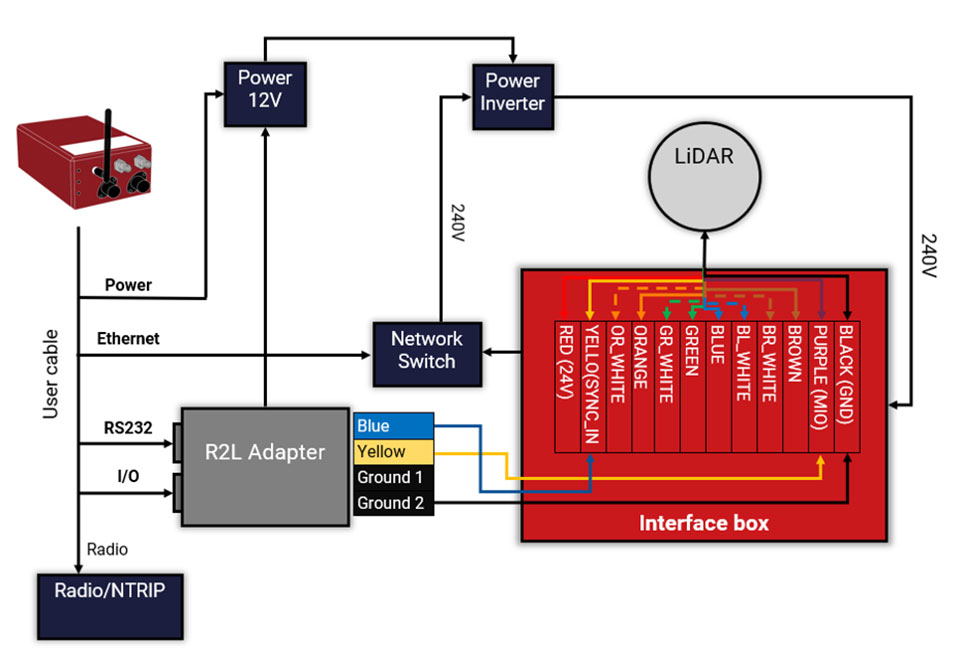
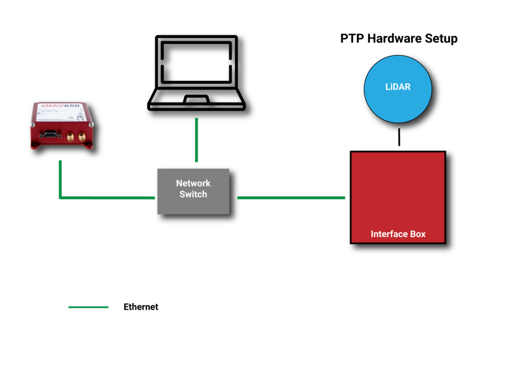
Oxford Technical Services (OxTS) has launched precision time protocol (PTP) master functionality on all of its next-generation inertial navigation systems (INS).
PTP is a network-based time synchronization protocol used to synchronize all clocks throughout a computer network. It is used in many industries, but most notably in finance to synchronize transactions, mobile-phone tower transmissions and subsea acoustic arrays.
Time synchronization
In many commercial organizations, millisecond-level device synchronization as offered with network time protocol (NTP) is sufficient. However, in surveying and automotive testing environments where there is more than one clock source (lidar and inertial navigation systems, or INS, for example), final results can suffer from time drift if millisecond — and not microsecond — synchronization is used.
Time drift becomes relevant as soon as you introduce more than one data acquisition system working in parallel. This is because each system will have its own timing error, and over time this error will grow and create drift.
For surveyors, time drift can negatively impact point clouds by making object recognition difficult, subsequently leading to blurring and double vision.
For automotive engineers, when running campaigns, analysis of events within your data may be misaligned, making the analysis more difficult and/or less efficient.
Stamp out time drift
To stamp out time drift, it is important to use the most accurate clock source available.
A key component of an INS is the GNSS receiver. The GNSS receiver acquires data, including timing information, directly from multiple GNSS constellations (GPS, GLONASS, BeiDou and Galileo). The GNSS receiver, coupled with the inertial measurement unit within the INS, allows users to benefit from the centimeter-level position accuracy that is so important in surveying and automotive testing environments.
These satellite systems house the most accurate time source possible — atomic clocks — meaning that devices connected to a network that includes an INS can take advantage of this time source owing to the GNSS receiver within the INS.
Simpler setup for lidar use
By migrating from a traditional PPS hardware set-up, which involves connecting and wiring multiple cables, to a PTP setup, which is essentially an Ethernet “plug-and-play” solution, users can also make day-to-day use of the equipment simpler and more efficient.
Without PTP – using PPS setup. (Image: OxTS)An example PPS hardware setup with a PTP-enabled network. (Image: OxTS)
This much-improved hardware setup allows surveyors and automotive test engineers to be up and running in a much shorter time frame than previously possible.
Adding value to the automotive industry
The addition of PTP also adds value for automotive users. With cars-under-test incorporating multiple sensors (lidars, cameras, etc.), synchronizing all that data can help support accurate analysis after the test is complete.
OxTS is continuing to develop its PTP solution by working on PTP slave functionality and improving the configuration process, which will provide greater flexibility in typical automotive setups that use data acquisition (DAQ) for larger sensor networks.
Summary
PTP as a time synchronization method is becoming more popular, particularly in the lidar industry, with manufacturers such as Ouster and Hesai enabling PTP on their sensors.
The shorter “time to survey” gives customers a much-enhanced user experience, and the higher quality final output on offer means that many users will demand their sensors are PTP-compatible before considering them for their projects.
Manufacturers of complimentary sensors, such as INS, need to build the capability into their product sets to allow them to be fit for the future.
Various OxTS INS are available to use PTP, including the new xNAV650, the company’s new small, lightweight and affordable INS for applications where payload size and weight matter. Learn more about the xNAV650 INS.
Users can also find out more about OxTS and its range of PTP-enabled devices by visiting its dedicated landing page, OxTS PTP-enabled INS devices.
Quectel Wireless Solutions, a global supplier of cellular and GNSS modules, debuted at CES 2020 a series of communication modules targeting the 5G connected car sector.
CES 2020, the massive annual consumer electronics show, is taking place Jan. 7-10 in Las Vegas. The three new modules are showcased at Quectel’s booth No. 2601.
Quectel’s new automotive-grade modules include the AG550Q, a new 5G New Radio (5G NR) Sub-6GHz module, the AG215S automotive EAP module, dedicated for C-V2X scenarios, and the AF50T Wi-Fi module.
All three modules are based on the Qualcomm Automotive Wireless Solutions from Qualcomm Technologies, Inc., a subsidiary of Qualcomm Incorporated. They are designed to provide multi-gigabit cloud connectivity, improved location services, and enhanced security to support the increasing requirements of connected car and autonomous driving use cases.
Image: Quectel
The AG550Q 5G NR module, supporting both NSA and SA modes, is based on the AEC-Q100 qualified Qualcomm Snapdragon Automotive 5G Platform. The module is compliant with IATF 16949 requirements, and follows automotive quality processes such as APQP and PPAP to address the demanding requirements of automotive devices.
Adopting the 3GPP Rel. 15 technology, the AG550Q supports high speeds and ultra-low latency to facilitate better security and quality-of-service for mission-critical services. The multimode 5G NR module is backward compatible with existing 4G, 3G and 2G technologies. This ensures that cars will remain connected regardless of where they travel within the network.
Supporting optional C-V2X PC5 direct communications, AG550Q provides superior performance in vehicle-to-vehicle (V2V) and vehicle-to-roadside infrastructure (V2I) communications for improved traffic efficiency and safety. Furthermore, the module supports optional Dual SIM Dual Activation (DSDA), which allows car and driver each to choose their own independent network operator subscription in order to support a variety of emerging mobility service models.
Additionally, the highly-integrated AG550Q module supports multi-constellation and multi-frequency GNSS (L1/L2/L5), as well as optional Qualcomm Dead Reckoning (QDR) 3.0 technology which provides quick and highly accurate location positioning. The module will be commonly found in telematics boxes (T-Box), telematics control units (TCU), advanced driver-assistance systems (ADAS), C-V2X (V2V, V2I, V2P) systems, on-board units (OBU), roadside units (RSU), and other automotive/traffic systems.
Quectel AG550Q module offers powerful cyber-security features, which include firmware secure boot, Trusted Execution Environment (TEE), network firewall, SELinux strong access control, TLS/SSL security protocols and more.
“We are proud to deliver global OEMs and Tier 1 suppliers the most advanced wireless connectivity available, which allow them to integrate the latest 5G technology into their next-generation car designs,” said Min Wang, vice general manager of Quectel. “Leveraging our relationship with Qualcomm Technologies and its cutting-edge chipsets, we have been able to offer auto customers secure and reliable connected car solutions. Our complete automotive portfolio ranging from LTE, C-V2X to 5G and Wi-Fi can satisfy the continuity of automakers’ future product planning.”
“As the automotive industry accelerates its adoption of cellular-based communications technology, our priority is to work with innovative partners like Quectel Wireless Solutions to meet the needs of the automotive industry as it delivers on the promises of automated mobility,” said Matt Eichenberger, senior director, business development, Qualcomm Technologies. “The hallmark of our work with partners is to engineer highly scalable cellular technology-based platform that enable automakers to reimagine the speed of innovation. This translates to more connected experiences and improved vehicle safety, as more cars are capable of communicating not only with the cloud but also with other vehicles, pedestrians and transportation infrastructure.”
Besides AG550Q, Quectel also unveiled an automotive EAP module AG215S at the show, which is dedicated to C-V2X applications, and features the Qualcomm Snapdragon 2150 platform. The module integrates powerful application processor to host an ITS stack and applications. Along with having a hardware crypto engine embedded to fulfill powerful ECDSA verification capability (with support for up to 2500 verifications/sec). AG215S supports the global, U.S., EU and China National Security Algorithm, which can greatly boost security in vehicle communications. Quectel will also provide the reference design platform with full functionality (Application Processor + Modem + Connectivity + GNSS + SW SDKs), for customers and application developers.
The Quectel AF50T Wi-Fi module targets the connected car sector and supports Wi-Fi 2.4GHz + 5GHz & BT 5.1, and 802.11a/b/g/n/ac/ax standards.
The AG550Q module is in the engineering sample stage, with the evaluation board available to reduce development time for OEMs and Tier 1 suppliers. The AG215S module will be sampling starting January 2020.
The ultra-robust M9 technology platform will suit demanding automotive and high-end telematics.
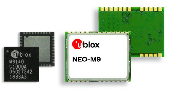
U-blox, a global provider of positioning and wireless communication technologies, has launched its new ultra-robust meter-level M9 global positioning technology platform, designed for demanding automotive, telematics and UAV applications.
Because of the high-performance GNSS UBX-M9140 chip, the M9 technology platform and the NEO-M9N (the first module based on the platform) can receive signals from up to four GNSS constellations (GPS, GLONASS, Beidou and Galileo) concurrently. It can achieve high positional accuracy even in difficult conditions such as deep urban canyons, u-blox said in a press release.
The u-blox M9 offers a position update rate of up to 25 Hz, enabling dynamic applications like UAVs to receive position information with low latency. It also features special filtering against RF interference and jamming, spoofing detection and advanced detection algorithms that enable it to report fraudulent attacks quickly so that users’ systems can react to them in a timely fashion.
A SAW (surface acoustic wave) filter combined with an LNA (low noise amplifier) in the RF path is integrated in the NEO-M9N module. This setup guarantees normal operations even under strong RF interferences, such as when a cellular modem is co-located with the NEO-M9N.
“We’ve developed the u-blox M9 as a follow-on from our very successful u-blox M8 GNSS platform, offering even more robust meter-level positioning technology and security features to protect the integrity of applications in the automotive, telematics, and UAV markets,” said Bernd Heidtmann, product manager, Product Strategy GNSS, Product Center Positioning, at u-blox.
Users of the u-blox M9 will benefit from it being part of the wider u-blox product family, which means that developers will be able to design a single PCB and then migrate to a different positioning technology — such as dead-reckoning augmenting GNSS technology — with little change to the board design.
Explorer kit released
U-blox has also released the Explorer Kit M9 (XPLR-M9), a development board for designers who want to assess the technology. The miniature plug-and-play device is supplied with user-friendly u-start software, which includes preset scenarios to enable users to explore the performance of the new device.
The u-blox M9 technology platform complies with the ISO/TS 16949, ISO 16750, AEC-Q100 standards. Engineering samples of the NEO-M9N, the first module based on the M9 platform, the UBX-M9140 high-performance chip, and the Explorer Kit are available now.
To learn more about M9, visit the u-blox booth, Hall South, S.2702, at Mobile World Congress 2019 in Los Angeles, Oct. 22-24.
SoftBank plans to introduce a centimeter-accurate, real-time satnav-based positioning service, specifically using Japan’s Quasi-Zenith Satellite System (QZSS), to guide autonomous vehicles across a range of industries in Japan. The company said it will install more than 3,300 control points at base stations across Japan to deliver centimeter-level accuracy over its mobile network coverage area to provide real-time kinematic (RTK) positioning.
Testing begins in July with a scheduled launch of commercial service by the end of November. Test partners include Yanmar Agribusiness Co., Ltd., a provider of autonomous assisted driving for agricultural machinery, Kajima Corporation, which performs construction site management with automatically controlled drones for aerial photography and monitoring, and SB Drive Corp., a provider of autonomous and assisted driving technology for buses.
SoftBank is developing proprietary low-cost GNSS receivers so that “new services and market expansion can be realized.” A Positioning Core System provided by ALES Corp. will generate correctional data based on signals received and transmitted by SoftBank’s own control points over SoftBank’s mobile communications network to agricultural and construction machinery, self-driving cars, drones and other equipment carrying GNSS receivers. The company expects that centimeter-level positioning can thus be done in real time.
In addition to control points at its own base stations, SoftBank will use the Geospatial Information Authority of Japan’s approximately 1,300 GPS-based control stations.
SoftBank is also developing services to enablec loud-based RTK positioning for devices without GNSS receivers. Cloud-based RTK will provide centimeter-level, location-based services for equipment that needs to be miniature and energy-efficient, such as infrastructure surveillance sensors and wearable devices.
SoftBank Group Corp. is a Japanese multinational conglomerate holding company headquartered in Tokyo. It owns operations in broadband, fixed-line telecommunications, e-commerce, internet, technology services, finance, semiconductor design and more. It is the 36th largest public company in the world, and the 2nd largest in Japan.
ALES is a joint venture established by SoftBank and Enabler in July 2018. Enabler employs GNSS and related technologies to produce such products/services as a synchronization solution for mobile base stations for subway stations and a patented indoor positioning/time synchronization infrastructure platform in Japan.
Autotalks, a vehicle-to-everything (V2X) communications company, has teamed up with Marben for a live V2X demo based on Marben V2X software running on Autotalks’ chipset.
The first live end-to-end global V2X demo will take place at the Autotalks booth (C198) at TU-Automotive Detroit, being held June 5-6 in Novi, Michigan.
Autotalks has been cooperating for several years with Marben, a global leader in embedded software solutions for the telecommunication and automotive industries. The joint effort led to the successful integration of Marben’s stack and software application on Autotalks chipset using the C-V2X standard.
The Autotalks solution minimizes development, testing and certification efforts for a V2X system to be deployed anywhere, using a software toggle between V2X technologies. This translates into a huge advantage for OEMs and Tier 1 automakers who benefit from the shortest time to market for a global V2X platform.
The chipset isolates V2X from the non-safety domains, thus providing domain separation and security, scalability and ability to optimize the cost structure of telematic control units (TCUs). The isolation of V2X combined with Autotalks’ recognized cyber security technology enables a secure platform.
“Our agility in maturing the C-V2X solution simultaneously with leveraging our V2X ecosystem partners for this purpose has yielded fast results and offers a clear deployment path for OEMs and Tier 1s alike. We appreciate Marben’s long-standing cooperation and are pleased to demonstrate the first end-to-end dual-mode V2X demo with them,” said Yaniv Sulkes, Autotalks’ VP of business development and marketing in North America and Europe.
Global software communications company Marben has developed a complete ready-to-use V2X software solution including security and several applications that are deployed worldwide. The company’s solution significantly increases road safety, optimizes traffic and contributes to greener mobility.
“We are glad to partner with Autotalks, and showcase this first of a kind demonstration, after our straightforward and quick C-V2X integration,” said Devang Naik, director of software engineering.
The live demo can be seen at the Autotalks booth C198 at TU-Automotive Detroit.
Senators Joni Ernst (R-IA) and Tammy Duckworth (D-IL) joined Representatives Dave Loebsack (D-IA) and Don Bacon (R-NE) in launching the Congressional GPS Caucus in March. This bipartisan, bicameral caucus will elevate the ever-increasing importance of GPS technologies to the U.S. economy and infrastructure. As evidence of that, today more than 3.3 million jobs in the United States rely heavily on GPS.
Agriculture is front and center in the states and districts these policymakers represent, and the cost savings as well as jobs and family incomes are noteworthy. Nationwide, GPS has led to $8.2 billion in savings through precision agriculture, while yielding increases in grain production across the country. Further, GPS has become an indispensable and reliable part of the country’s national infrastructure. Public and private investment in GPS-based technologies and services have produced a steady stream of innovations, making the U.S. a global leader in the sector.
The GPS Caucus will prioritize ensuring GPS signals remain continuously available, accurate, reliable and resilient. To better support the long-term health and future of GPS, the caucus plans to host educational briefings and technology demonstrations, in addition to advocating for policies that keep GPS at the forefront. On April 2, these efforts will kickoff with a “GPS 101” educational briefing on the Hill featuring remarks from Senator Duckworth, Representative Loebsack, Colonel Curtis Hernandez, US Air Force Director National Security Space Policy, National Space Council and industry leaders from Deere & Company, Garmin and Trimble.
To further reaffirm the critical importance of GPS, the GPS Caucus introduced concurrent resolutions in both the Senate and House. The resolutions outline the economic benefits of GPS, totaling more than $68 billion to the U.S. economy each year, and the sectors GPS technology supports, none of which would be possible without the contributions made by the men and women of the Air Force who maintain the GPS constellation.
As efforts to advance 5G, precision agriculture and smart cities continue, GPS will only become more valuable to modern-day operations and it remains critical that policymakers, companies and industry leaders alike, foster policy that keeps GPS at the forefront.
OriginGPS, maker of small-format GNSS modules and cellular internet of things (IoT) systems, presented new products with customized IoT and GPS demonstrations at Embedded World 2019, Nuremberg, Germany, Feb. 26-28, Hall 3, Booth 3-121.
OriginIoT systems enable developers to rapidly develop IoT products with stackable add-ons, while all data is configured from the cloud, and no additional embedded code or RF knowledge is required.
OriginGPS’ latest release is the multi-constellation ORG1518-MK06 module. It combines low power modes for extended battery life, 8MB built-in Flash memory, AGPS support for extended ephemeris improving position calculation, and UART+I2C or UART+SPI interfaces.
Selectable add-on sensor boards click on the OriginIoT cellular IoT system, offering backward compatibility with 2G, 3G, CAT1 and CAT M. (Image: OriginGPS)
An ultra-sensitive integrated patch antenna easily switches over to an external antenna via an integrated RF switch.
The ORG1518-MK06 is suitable for solutions requiring multiple antenna options, such as automotive aftermarket and agriculture applications.
Addressing the global IoT market with fast data transmission, the OriginIoT NB-IoT/CAT M with 2G fallback will be suited to devices that are battery-powered and transmit data only occasionally, such as parking and agriculture applications, resulting in a very long sensor battery life, typically 10+ years. The new model will be released later this year.
“The new products are based on OriginGPS patented technologies and retain the miniature footprint for which the company has become synonymous,” said Robert van Tilburg, vice president, Global Sales and Business Development, OriginGPS. “We are excited to offer our customers additional features and options to choose from, enabling them to reduce overall solution costs. 2019 is going to be an exciting year with technology advancements facilitating our product offering with more personalized IoT and GNSS products.”
OriginGPS partner Gemalto will also be presenting OriginIoT demos at Hall 3, Booth 3-438. Gemalto’s Cinterion LTE-M module is integrated in the OriginIoT systems to provide 2G, 3G, Cat1, Cat-M and NB-IoT cellular communication.
TDK Corporation has introduced a new line of automotive high-accuracy devices from InvenSense, a TDK group company. The line includes the IAM-20680, IAM-20680HP, IAM-20380 and IAM-20381.
According to the company, its family of automotive solutions can help enhance the absolute position of a vehicle in GNSS- and GPS-denied environments. They also can be interchanged without the need to redesign hardware or software.
The IAM-20680 is a 6-axis qualified sensor that features 16-bit accelerometers and 16-bit gyroscopes. The IAM-20680HP is a high-performance version of the IAM-20680 that features high gyroscope and offset thermal stability. The IAM-20380 is an automotive-qualified gyroscope fully compatible with a 3-axis automotive accelerometer and an automotive-qualified 6-axis device. The IAM-20381 is an automotive-qualified 3-axis accelerometer fully compatible with a 3-axis automotive gyroscope and an automotive-qualified 6-axis device.
The IAM-20680HP and IAM-20680 can be used to improve estimates of the position, direction and speed of a vehicle when the satellite signal is deteriorated or non-existent, as well as to improve the quality of the position estimation when the satellite signal is strong, the company said. Customers can design with the IAM-20680 and can use the IAM-20680HP when navigating in high temperature environments or for systems where cooling is weak or unavailable.
If cost efficiency is an important consideration, the company recommends the IAM-20380 or IAM-20381.
“With the increased usage of location services for turn-by-turn navigation, the importance of not losing your GPS or GNSS signal due to environments like tunnels, parking garages and urban canyons is paramount,” said Amir Panush, vice president and general manager of the Motion and Pressure Business Unit at TDK. “With a full family of InvenSense product offerings that are automotive qualified, OEMs have a plethora of options to differentiate the user experience and supply consumers with more reliable navigation solutions.”
The IAM-20680 and IAM-20680HP are also designed into the new InvenSense Coursa Drive software solution, an inertial-aided positioning software solution for autonomous vehicle platform developers.
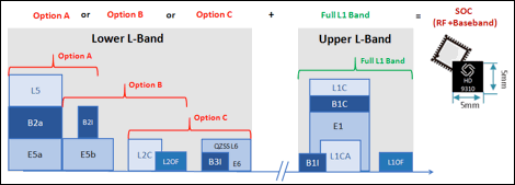
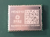
Allystar Technology Co. Ltd., headquartered in Shenzhen, China, has released a multi-band multi-GNSS chipset, the HD9310. The new product is based on the Cynosure III architecture integrating multi-band multi-system GNSS RF and baseband.
A multi-band, multi-system system-on-chip, it supports BeiDou-3 and is capable of tracking all global civil navigation systems (GPS, BeiDou, Galileo, GLONASS, IRNSS, QZSS and SBAS) in all bands (L1, L2, L5, L6), said Simon Sun, Allystar general manager.
Photo: Allystar Technology
Designed for high-precision applications, the HD9310 measures 5.0mm x 5.0mm. The architecture integrates floating-point arithmetic units based on ARM CortexM4, 160 KB RAM, 32KB backup RAM with VBAT, 386 KB embedded FLASH and peripheral interfaces UART, I2C, SPI, GPIO, CAN.
In terms of the manufacturing processes, it adopts a 40nm process and incorporates a variety of advanced design technologies, endowing it with very power consumption: less than 50mA.
The quad-flat no-leads package allows customers to reduce printed circuit board and bill of materials costs while reducing the number of peripheral devices. This chip supports CAN interface and can be widely used in vehicle management, car navigation, wearable devices, GIS data collection, precision agriculture, smart logistics, driverless, engineering survey and other fields.
“The HD9310 supports three options of RF setting — A, B, C — for product developers to quickly bring their ideas to the different application and markets,” added Shi Xian Yang, high precision project manager at Allystar.
Three available options for the HD9310 chipset. Graphic: Allystar Technology
Option A, focused on L5 band, L5/E5, maximizes measurement accuracy and improves multipath mitigation based on higher chip rate.
Option B is focused on L2 band, and suitable for relative position applications, for example, real-time kinematic (RTK), because worldwide continuously operating reference stations (CORS) commonly support L1/L2/L1OF/L2OF.
Option C is focused on the L6 band and is designed for PPP applications, receiving state space representation (SSR)-type corrections to be broadcast from satellites in the coming future, and supporting B3I already.
The HD9310 comes with built-in support for standard RTCM Protocol (MSM), supporting multi-band multi-system high-precision raw data output, including pseudo range, phase range, Doppler, SNR for any kind of 3rd party integration and application.
Module. Allystar Technology also has launched a multi-band multi-GNSS module, TAU1302, which integrates the HD9310 chipset and measures 12 × 16 × 2.3 millimeters.
With the features of small size, low power consumption (<50 mA), and ease of integration and mass production, HD9310 is suitable for high-precision applications such as vehicle management, car navigation, wearable devices, GIS data collection, precision agriculture, smart logistics, driverless, engineering survey and other fields.
Customer samples of the HD9310 chipset are available now.
“As of today [Nov. 28] Tesla owners have driven 1 billion miles with Autopilot engaged,” the company announced via tweet.
The Autopilot feature became available in 2015 and now comes on all new Tesla models with a $5,000 activation fee at the time of purchase or $7,000 if selected later.
The company is training its “neural networks” to improve its self-driving system.
Photo: Tesla
Tesla’s global fleet totals more than half a million vehicles, and recently marked a 20-billion mile step of total electric miles driven, the company said.
The Autopilot system can also function in the background of the vehicle, without being activated and with no input on control. Thus it gathers data from many more billions of “drivered” miles about its environment and potential Autopilot behavior.
The company previously mentioned the 1 billion-mile autonomous mark as the minimum it would need to move Autosteer from beta to a regular feature.
Updates to Autopilot are planned for 2019, including new hardware that will aid in the rollout of the company’s Full Self-Driving system, possibly by the end of that year.