More than 8,000 industry leaders and professionals from more than 55 countries are discussing the latest innovations in the unmanned systems market this week. Hundreds of educational sessions are providing information about the future of unmanned systems policy, regulations and technology. Also, the show’s Startup Showdown has $15,000 in cash prizes and mentorship opportunities for start-up companies.
Award-winning journalist Miles O’Brien, the science correspondent for PBS NewsHour, is hosting the event. Keynote speakers include Michael P. Huerta, administrator of the Federal Aviation Administration (FAA); Gen. David G. Perkins, commander of the U.S. Army Training and Doctrine Command; Gur Kimchi, co-founder and vice president of Amazon Prime Air; and John Chambers, executive chairman of the board of Cisco Systems.
A panel of industry thought leaders, moderated by AUVSI’s president and CEO Brian Wynne, are discussing the future of unmanned systems: U.S. Rep. Frank LoBiondo, chairman of the House aviation subcommittee; Frank Kelley, deputy assistant secretary of the U.S. Navy for Unmanned Systems; Marke Gibson, senior advisor for UAS integration at the FAA; and John Cavolowsky, Ph.D., director of NASA’s Airspace Systems Program.
Check back throughout the week for event updates, including news, photos, videos, tweets and more.
Arcturus UAV reports the Mexican Navy has deployed its T-20 Jump fixed-wing vertical take-off and landing (VTOL) UAV for unspecified operations in Mexico. The customer took delivery of the VTOL system in March.
The T-20 Jump is a VTOL variant of Arcturus UAV’s catapult launched T-20 platform. It operates without any special launch or recovery equipment. Gross payload capacity is 60 pounds.
The Mexican Navy configuration with an electro-optics and infrared (EO/IR) sensor has approximately 15 hours of endurance and a 75-mile data-link range. An EO/IR and EW capable version offers 11 hours of endurance. Mexico has operated a fleet of catapult launch T-20s since 2014.
Arcturus has proposed the T-20 Jump VTOL platform for MEUAS III, the United States Special Operations Command‘s (USSOCOM’s) worldwide UAS services contract. Arcturus has also proposed a heavy fuel version of the T-20 Jump for the Royal Australian Navy’s Tactical Unmanned Aircraft Program.
Insitu is showcasing its new commercial business unit and platform of professional aviation products and services at the Association for Unmanned Vehicle Systems International’ Xponential 2016 May 3-5 in New Orleans.
In booth 2213 in Hall 2, the company will highlight:
canEagle and RQ-21A Blackjack air vehicles.
Inexa | Control, a ITAR-free ground control station that gives operators professional aviation tools to safely operate unmanned systems while staying compliant with emerging Federal Aviation Administration (FAA) regulation.
FLARES, Insitu’s new Flying Launch and Recovery System that launches ScanEagle from the air and captures without ground equipment, expanding the environments where unmanned operations are possible to include jungles, courtyards and other small or restricted spaces.
The Insitu-Orbital Engine, an internal combustion propulsion system to be engineered from the ground up for small unmanned aerospace application. The engine is designed and tested to the FAA’s airworthiness standards for manned aircraft engines. In March, Insitu received a Commodity Jurisdiction from the U.S. Department of State placing its Multi-Fuel Direct Injection Engine under the export control purview of the U.S. Department of Commerce, Bureau of Industry and Security.
Microsoft HoloLens demonstrations. Microsoft’s high-definition hologram technology is integrated with Insitu’s Inexa | Control software to offer a new view of how decision makers and operators might manage unmanned systems in complex environments in the future.
Insitu is a wholly owned subsidiary of The Boeing Company.
Electronics manufacturer uAvionix has introduced the smallest and lightest ADS-B receiver, according to the company. The new pingRX weighs 1.5 grams and requires one hundredth the power of conventional ADS-B (Automatic Dependent Surveillance – Broadcast) receivers. It implements “sense and avoid” capabilities for small drones operating in the National Airspace (NAS).
The receiver, for use in small drone collision avoidance systems ADS-B, helps aircraft operators sense and avoid possible collisions. ADS-B is mandated by the U.S. Federal Aviation Administration for all aircraft in the NAS in 2020. Used now primarily on manned aircraft, miniaturizing the equipment was essential to make it useable for small drones, uAvionix says. pingRX measures 32 by 15 by 3 millimeters, which is a fraction of the size of earlier units.
Early adopter Randy Mackay, lead developer of ArduCopter, said to the company that it “feels slightly magical to have real aircraft appearing on our ground station map.”
pingRX receives ADS-B information broadcast by other aircraft on two frequencies approved by the FAA (978 megahertz and 1090 megahertz). This allows the unit to detect commercial aircraft threats within a 100 statute mile radius in real time.
For drone aircraft system installation, pingRX is designed for direct MAVLink integration with Pixhawk autopilots and APM Mission Planner software.
uAvionix will display its new patent-pending pingRX ADS-B receiver at the Association for Unmanned Vehicle Systems International’s Xponential trade show May 3-5 in New Orleans.
Draganfly Innovations has added support for GLONASS satellite navigation, which will provide higher accuracy and function in more locations than GPS alone.
The more satellites that a receiver can see, the more accurate the calculated position is. Adding GLONASS support allows additional satellites to be detected, which is important in situations where fewer satellites are in line of sight because of obstruction by mountains, buildings, trees and other objects, the company said in announcing the addition.
The Draganflyer Commander, X4-ES, and X4-P unmanned aircraft systems (UAS) now use GNSS receivers that support both GPS and GLONASS. More accurate positional data allow these UASs to hold position more precisely and to better geo-locate images, which in turn provide higher quality data.
“This is great for our customers, especially those operating in locations where GPS doesn’t work well,” said Draganfly President Zenon Dragan.
GLONASS in conjunction with GPS allows Draganfly UAS’ to geo-locate more precisely.
TerraStar-L, a new 40-centimeter (cm) precise point positioning (PPP) correction service, is coming next week from NovAtel.
TerraStar-L is a subscription-based correction service that delivers GNSS correction data via satellite to users of precision navigation systems. With position accuracy of 40 cm, TerraStar-L is designed for broad accuracy applications such as agriculture, geospatial information systems (GIS) and unmanned vehicle navigation, particularly where tree lines, buildings and other obstructions can be an impediment to continuous positioning.
With the addition of the TerraStar-L correction service, NovAtel now offers two levels of PPP corrections through its NovAtel CORRECT positioning engine; the new 40-cm accuracy service and a 4-cm service through its TerraStar-C solution.
By offering two diverse accuracy options, customers have the flexibility to choose the performance level best suited to their application. The correction data for both services provides consistent worldwide accuracy and is delivered over satellite which eliminates the need for a local base station.
“The robustness and redundancy built in to the TerraStar network infrastructure makes TerraStar correction data extremely reliable,” said Sara Masterson, business development manager of correction services at NovAtel. “When our customers operate in environments with obstructions that can block GNSS signals, TerraStar-L offers a repeatable 40-cm solution, reducing position drifts or jumps. This maximizes uptime and productivity for our customers by providing fast initialization to a reliable decimetre position.”
NovAtel CORRECT with PPP combines GNSS satellite clock and orbit correction data from TerraStar’s global reference station network service to deliver solutions with high accuracy and instant re-convergence in challenging environments.
TerraStar-L will be available for order from NovAtel starting May 4.
Unmanned aerial vehicles (UAVs) — both their design and their many applications — are the topic of GPS World‘s May webinar. The free webinar is scheduled for Thursday, May 19, at 1 p.m. EDT. Register here.
The webinar, sponsored by Septentrio, will engage you in discussions involving:
Read the full details of each of the speakers’ presentations below.
Dennis Akos, Professor, University of Colorado at Boulder
Subtopic 1: GNSS Robustness for Unmanned Aircraft Systems Presented by Dennis Akos, professor, University of Colorado at Boulder, and Joshua Stubbs, Ph.D. candidate
When siting the antenna of a GNSS receiver or designing a GNSS-based navigation system, electromagnetic compatibility is an important concern. This is particularly true for airborne platforms. Akos discusses how radio-frequency interference can impact GNSS equipment on unmanned aircraft systems and how robustly the equipment can navigate those systems.
Joshua Stubbs, Ph.D. candidate
Subtopic 2: Autonomous Relative Navigation Presented by Dr. Jeff Fayman, CTO, Geodetics
Future UAVS will require relative navigation capability to fulfill a broad range of assisted manned and unmanned missions. A new approach, demonstrated in application to aerial refueling, provides access to accurate relative time-space positioning information (R-TSPI) between platforms.
Subtopic 3: UAV Operation in Industrial Environments Presented by Roy Jeunen, founder, AiRobot
The distance from an in-flight UAV to the industrial asset that it is observing or inspecting obviously has critical importance for safety, data precision and cost-effectiveness. The AiRobot Ranger counters this problem by displaying the distance between the UAV and the object of interest on multiple smart phones or tablets, ensuring the extra situational awareness that is crucial for professional UAV operations.
Jan Leyssens, Product Manager, Septentrio
Subtopic 4: Practical Tips on How to Avoid Problems While Integrating High-Accuracy GNSS Receivers Aboard UAVs Presented by Jan Leyssens, product manager, Septentrio
Register today.If you can’t attend the live event, you are invited to still register — you will be sent the on-demand version 24 hours after the event concludes. The on-demand version will be available until May 19, 2017.
A man took a video of his 70-year-old mother’s reaction to a Tesla Model S on Autopilot. Sitting in the driver’s seat, the woman screams, pleading with her son to put her back in control of the vehicle.
As the popularity of drones for personal use continues to increase,most of the people who have bought them are sensible folks who have registered their vehicles with the FAA (in the U.S.) and other authorities elsewhere. They respect the rules that have been laid down for them to operate — fly below 400 feet (recently increased by the FAA from 200 feet), don’t fly over populated areas or people, and especially stay away from airports and the departure and approach paths for regular aircraft.
So it’s especially troublesome for these law-abiding drone owners when a wildcat operator gets into the approach path at an airport — and it’s really bad if that airport happens to be one of the busiest in the U.S.
Unfortunately there are several examples. For instance, a Lufthansa A380 pilot recently reported that a drone passed approximately 200 feet above the huge A-380 aircraft he was flying while it was at 5,000 feet altitude on approach into LAX (Los Angeles airport). The FAA immediately got on the phone to the Los Angeles Police Department responsible for air support.
Just last week, an unmanned aerial vehicle (UAV) was reported to have struck a British Airways Airbus as it descended into London’s Heathrow Airport.
The increase in drones might be compared to an increase in the bird population, and a recent study concluded that the risk to the airspace caused by single, light-weight drones is probably quite low. The figures also seem to say that the probability of bird-strikes is very low — but tell that to Captain Sullenberger who landed a smaller A-320 in the Hudson River when both engines quit after ingesting geese just after take-off.
It seems that good airmanship and eyesight have so far avoided any drones being sucked into commercial aircraft engines — no thanks to a small number of irresponsible drone flyers who are tempting fate by intruding into “no-go” airspace.
Let’s get the FAA small UAV regulations published and give everyone clear rules by which even these people are required to fly their drones. So far, individual section 333 waivers have been granted by the FAA to known characters who apparently want to do things properly. Rules also presumably come with penalties, so we might have some deterrence and more control over wildcat operators.
Along the same lines, the FAA is researching a new approach which could detect drones and find their operators who fly near airports. The FAA has implemented a number of programs and tools to educate drone operators and make them aware of the dangers of encroaching on controlled airport airspace, but even so, such incidents continue to occur.
CACI International has therefore been awarded a Pathfinder contract by FAA to investigate technology that will allow the FAA to “identify rogue unmanned aircraft systems” near airports. The CACI solution aims to provide a proven way to passively detect, identify and track UAS/drones and locate their ground-based operators. So, hopefully we may soon have regulations along with a detection system for rule breakers, and we’ll then need an approach to administer penalties. Much better! But let’s pray in the meantime that we don’t have any drone/Sullenberger incidents.
The FAA has recently predicted sales of commercial UAS will increase from 600,000 in 2016 to 2.7 million by 2020, so we better get a handle on this soon. It’s even forecast that there could be a jump to 2.5 million commercial UAS sold in 2017 should the FAA get its small UAV regulations out and implemented this year, as the agency has announced.
Meanwhile, the FAA has turned to an industry/agency committee to ask if they could relax the FAA’s own rules for very small drones and under certain conditions allow them to fly over people. The committee — known as the Micro Unmanned Aircraft Systems (UAS) Aviation Rulemaking Committee (the “ARC”) — met and quickly published a report that came up with four categories of small UAV, Category 1 being less than 250 grams and requiring virtually no additional regulation. Basically, a 250 gram drone falling on a person is considered unlikely to hurt anyone. The other categories do need more restrictions, and manufacturers will need to do significant testing to qualify their drones to satisfy the new requirements.
The latest version of the Amazon delivery drone.
Amazon is also trying to do its part to warn people that a drone might be close overhead. The company recently filed a patent for propellers on drones that could emit warning noises in certain phases of flight. As Amazon progresses toward its plan to deliver parcels to homes, it’s looking to enhance the safety of its future drone-based delivery system.
The object of the patent is to have drone propellers alert people on the ground of the drone’s presence, possibly by broadcasting audible phrases such as “watch out.” Maybe a couple of holes in a propeller might even result in a whistling sound that people would begin to associate with an incoming drone?
DJI
Meanwhile, DJI in China remains one of the companies enjoying stratospheric growth as a result of this growing demand. DJI only really surfaced as a drone supplier in the last few years after the release of the Phantom quadcopter, but DJI has actually been around for 10 years. The founder studied in Hong Kong and became interested in flight control systems, which DJI went on to develop. The company started with 20 people based in Shenzhen where there is good access to high-tech talent, but they have now exceeded 5,000 employees. With R&D engineering centers in Asia, Europe and the U.S., DJI now claims to have captured 70 percent of the commercial drone market.
The DJI Phantom 4.
DJI’s focus is to provide drones that are easy to fly, with a great user interface, and then hang high-quality cameras and other sensors on these really maneuverable platforms. Their approach seems to be working — sales are currently growing by around 3-5 times a year, and they also claim to have a valuation of at least $10 billion US!
DJI tells us that its customers have taken 70 million photos, flown 125 million miles, and operated for 3.9 million hours, with applications including agriculture, search and rescue, sports and news broadcasting, real estate, tourism, wildlife monitoring, archaeology, surveying and mapping, education and dozens of others. DJI is also one of the first manufacturers to introduce geofencing using GPS to ensure operation only in areas that are permitted.
With a product range that not only has drones for commercial and industrial applications, but also includes flight control systems, still and video cameras and stabilized gimbals for airborne and handheld camera applications, DJI is very well placed to maintain its strong market position.
AUVSI Convention
Early next month, the Association for Unmanned Vehicle Systems International (AUVSI) holds its major annual convention in New Orleans, and GPS World will have a contingent of inquisitive people scouring the show floor for news items. So we will have lots more drone stories to tell.
On Monday, April 18, an unmanned aerial vehicle (UAV) was reported to have struck a British Airways Airbus as it descended into London’s Heathrow Airport, reports BBC News.
The collision has renewed calls from the Air Line Pilots Association for stricter regulation in the U.S., where more than 150 airliners reported close sightings of drones in the last 18 months, including eight in the last two weeks of January. A drone collision could disable an aircraft if the metal frame and battery of a drone come in contact with an airliner’s engine.
Authorities in Britain are investigating the incident, and trying to determine who might have been behind it.
British Airways Flight BA727 from Geneva was approaching Heathrow on Sunday afternoon when what the pilot believed to be a drone struck the front of the aircraft, London Metropolitan Police said. The plane was 1,700 feet in the air at the time.
The Airbus A320 landed safely, with none of the 132 passengers and five crew members on board injured, British Airways spokesman Michael Johnson said. The plane was fine, and continued with service.
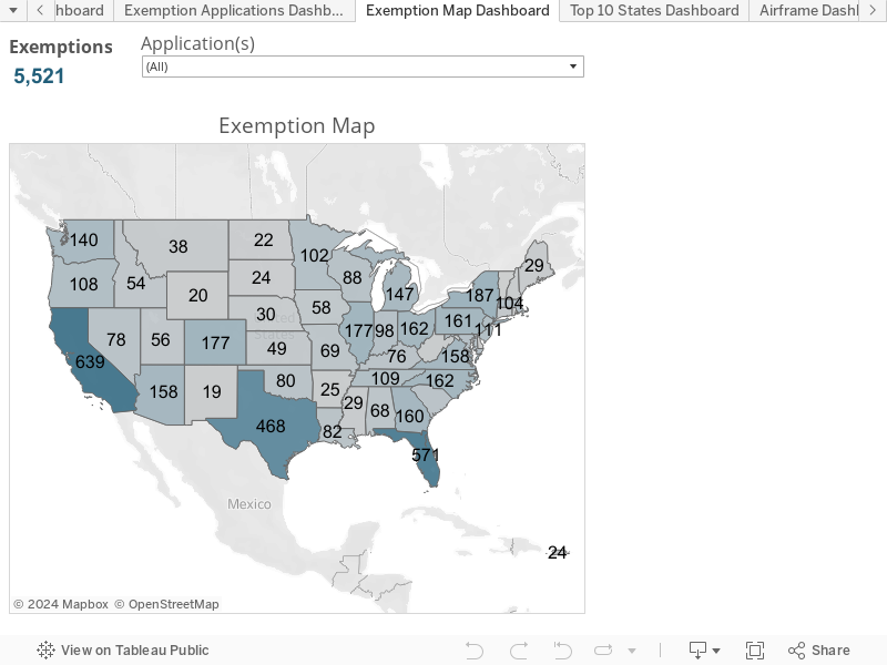
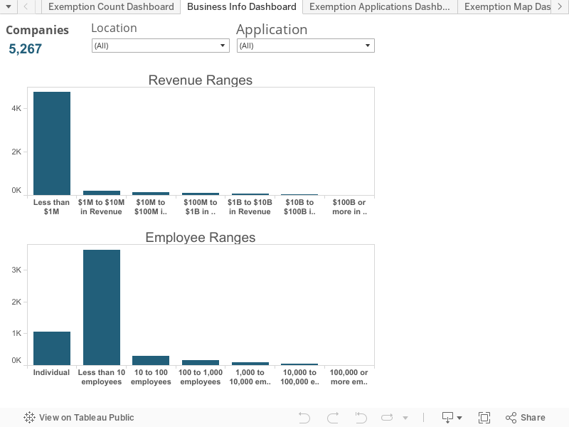
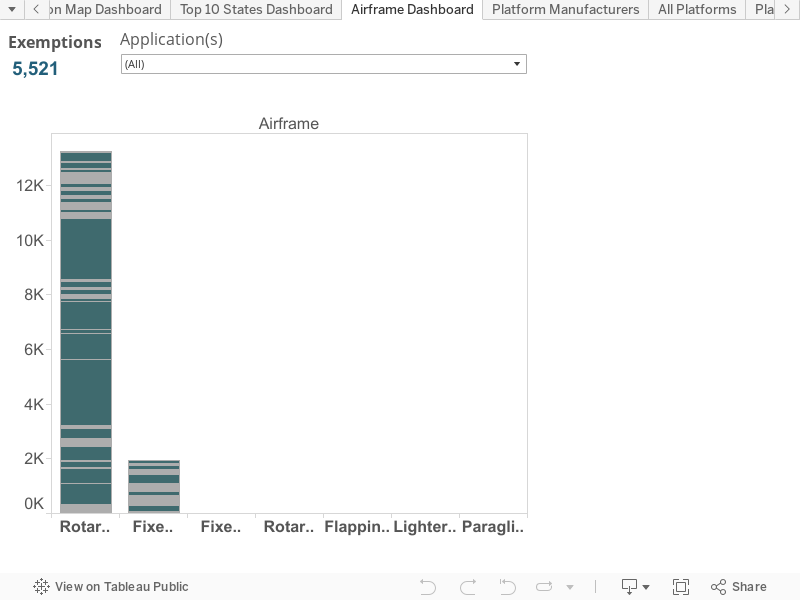
The Association for Unmanned Aerial Vehicles (AUVSI) unveiled an interactive analysis of U.S. Federal Aviation Administration (FAA) Section 333 unmanned aircraft system (UAS) exemptions.
The FAA has awarded more than 3,000 Section 333 Exemption Grants since September 2014 to allow individuals, businesses, non-profits and governmental agencies to fly drones.
AUVSI’s Unmanned Systems and Robotics Database provided the data for the analyses, which shows UAS exemptions by state and month, a business analysis revealing revenue and employees, UAV applications, top manufacturers, top drones, airframe and industry.
The report finds that finds 38 types of business operations have been approved by the FAA to fly UAS commercially in the National Airspace System (NAS). Aerial photography received the most, followed by real estate and aerial inspection.
The report also finds that exemptions have been approved in all 50 states, as well as Puerto Rico.
“The UAS industry is poised to be one of the fastest growing sectors in the U.S., and these numbers demonstrate that a wide variety of industries are eager to take advantage of this technology,” said Brian Wynne, president and CEO of AUVSI. “From inspecting our nation’s infrastructure to providing farmers with aerial views of their crops, the applications of UAS are virtually limitless. It’s no wonder businesses – small and large – are clamoring to use this technology.”
Congress also mandated that the FAA develop rules for integration of UAS into the national airspace, however these rules, which would provide anyone who follows the rules access to the airspace, are not expected until at least June 2016.
The Federal Aviation Administration (FAA) is now reviewing the report and recommendations of the Micro Unmanned Aircraft Systems (UAS) Aviation Rulemaking Committee. The agency had tasked the group to develop recommendations for performance-based regulations that would let certain unmanned aircraft operate over people not directly involved in the flight of the aircraft.
The rulemaking committee, which began meeting March 8, worked under a tight deadline of April 1 to deliver its report. The task force included a diverse set of aviation stakeholders, including UAS manufacturers, UAS operators, consensus standards organizations, researchers and academics.
“We commend the committee members for their sincere dedication and for producing a comprehensive report in such a short time,” said FAA Administrator Michael Huerta. “This type of collaborative government and industry partnership is exactly what is needed to keep pace with this rapidly changing industry and will serve as a model for future rulemaking advisory tasks.”
The ARC’s consensus report recommends establishing four small UAS categories, defined primarily by risk of injury to people below the flight path. For each category, the group recommends assigning a potential risk linked to either weight or impact energy. The report also addresses operational restrictions and standards to minimize the risks associated with each category.
The FAA will use the information in the report to develop a flexible, performance-based proposed rule. The public will have an opportunity to comment on the proposal based on the ARC’s recommendations.

 Electronics manufacturer