KenCast showcased its real time video technology for drones at the Association of Unmanned Vehicles International‘s Xpontential 2016 show, held May 2-5 in New Orleans. Doug Bogan of KenCast discusses applications of the product, which broadcasts content in full HD via bonded 4G/LTE or satellites.
Tag: autonomous vehicles
-
Cobham showcases multi-axis gimbals at AUVSI’s Xponential 2016
Cobham exhibited its series of multi-axis gimbal systems at the Association for Unmanned Vehicle Systems International‘s Xponential 2016 show, held May 2-5 in New Orleans. Cobham’s Alex Doig explains that the system can be stabilized for ground, air or shipboard platforms.
-
KVH highlights line of IMUs for unmanned systems at AUVSI’s Xponential 2016
Sean McCormack, director of FOG/OEM sales for KVH Industries, talks with GPS World Contributing Editor Tony Murfin about the company’s line of inertial measurement units (IMUs) during the Association for Unmanned Systems International‘s Xponential show, held May 3-5 in New Orleans.
-
UAV reaches new heights in Tibet
 In the Himalayas, MAVinci GmbH has operated a Sirius Pro unmanned aircraft system (UAS) at an altitude of 4,800 meters above sea level (ASL).
“Take-off altitude was 4,150 meters ASL. The flight was performed at BaSu County, ChangDu, Tibet,” the company shared in an email. “This is a new altitude record for us! Thank you to everyone who supported this mission!”
MAVinci manufactures UAS for surveying professionals, designed to enable easy and quick surveying and documentation.
The MAVinci Surveying Sirius Pro is manufactured in Germany. It is a fixed wing UAV with a 1.6-meter wingspan and less than 3-kilogram take-off weight.
The Siruis Pro guarantees high precision without setting control points on the ground, according to MAVinci.
Using a Topcon receiver and navigation system, it precisely measures the camera position for each image, making it equivalent to a control point. With the control points virtually set from the air during the flight, their coordinates calculated in real time.
-
Research Online: Laser localization system implementation, UAS sense and avoid integrity
Implementation of a Laser Localization System
By Aidan F. Browne and David Vutetakis, The University of North Carolina at Charlotte.
Presented at IEEE/ION PLANS 2016 in Savannah, Georgia.A novel laser-beacon localization system has been developed that has applications in positioning and navigation of mobile ground or aerial vehicles where other forms of localization are absent (such as GPS). The system allows for accurate position determination within an area of interest with reasonable accuracy.
The overall operation of the system is accomplished using only two external co-located beacons and a single on-board detector to perform pseudo-triangulation. The two beacons are spaced two meters apart, and continuously scan the area of interest in a sweeping fashion. As a beacon sweeps across the area of interest, its instantaneous angle is encoded in the pulse frequency of its emitted laser beam using a unique range of frequencies. A rotating detector on the vehicle is continually scanning over a 360-degree arc; it captures and decodes received beacon information in combination with its own relative angle at time of receipt.
The system has been successfully modeled in MATLAB to evaluate its effectiveness in terms of spatial localization accuracy under thousands of scenarios as well as to analyze the effects of the error parameter variations.
A prototype of the system has been realized using stepper motors, TTL-modulated 4.5 milliwatt line-generating lasers and a transimpedance amplified photodetector. Initial system testing has been promising with consistent results, indicating that the assumed error levels for the model were reasonable. Testing is underway to validate the results of the model and demonstrate the feasibility of the system.
UAS Sense and Avoid Integrity
By Michael B. Jamoom, Mathieu Joerger, and Boris Pervan, Illinois Institute of Technology
Presented at IEEE/ION PLANS 2016 in Savannah, Georgia.Sense and avoid (SAA) concepts and methods can be tools for certification authorities to set potential requirements for integrating unmanned aircraft systems (UAS) into the National Airspace System.
One new method seeks to ensure the safety of SAA functions for UAS in the presence of multiple intruders. Integrity and continuity are used as quantifiable safety performance metrics, and are addressed though determination of the probability of data mis-associations for multiple intruders. A miss-association occurs when the system incorrectly associates one intruder’s measurement with another intruder’s trajectory. Incorrect intruder associations are hazardously misleading information, impacting integrity. Likewise, a detected mis-association can result in a break in the continuity of the SAA operation.
A sensitivity analysis is performed based on two two-intruder encounters. The resulting impact of mis-associations between multiple intruders on integrity and continuity is quantified for a nominal composite SAA sensor.
-

Falcon Unmanned CEO to speak at GPS World UAV webinar

Chris Miser, CEO A fourth speaker has joined the line-up of experts in unmanned aerial vehicles (UAVs) who will share their know-how in UAV design and applications in a free GPS World webinar May 19.
Chris Miser, CEO and owner of Falcon Unmanned, will discuss a topic important to all of our readers: the practical considerations to integrate a professional GNSS receiver on a drone.
The free webinar will take place Thursday, May 19, at 1 p.m. U.S. Eastern / 7 p.m. Central European Time. Register here for “UAV Design and Applications: Autonomous Relative Navigation and GNSS Robustness for UAV Systems.”
Constantly evolving, it’s no wonder keeping up on the latest in UAV design and applications can be challenging. In the webinar, speakers will engage you in discussions involving:
- Self-generated radio-frequency interference aboard UAVs. (Presented by Dennis Akos, Professor, University of Colorado at Boulder, and Joshua Stubbs, Ph.D. candidate)
- An autonomous relative navigation tool for in-air UAV refueling. (Presented by Jeff Fayman, CTO, Geodetics)
- GNSS integration aboard small UAVs (Presented by Chris Miser, CEO, Falcon Unmanned)
- Considerations for multi-GNSS integration onto UAV platforms. (Presented by Jan Leyssens, Product Manager, Septentrio)

About Falcon Unmanned. Falcon Unmanned provides professional tactical unmanned aircraft systems for public safety agencies and commercial sector customers, as well as anti-poaching / conservation activities.
Falcon has several modular payload options providing multi-mission capability including live video missions (day or night), photogrammetry, high-resolution aerial photography and multispectral sensing.
In April, Falcon Unmanned delivered the first round of Falcon (fixed-wing) and Falcon Hover (quadcopter) aircraft to the U.S. Department of Interior (DOI) as part of a four-year IDIQ vendor contract. Falcon Unmanned is tasked with providing a complete array of aircraft, payloads, ground control stations, training and support services.
Falcon Unmanned successfully completed DOI/NASA airworthiness testing for its Falcon and Hover models, becoming one of only a handful of UAVs with a U.S. federal agency airworthiness evaluation.
Falcon and Hover meet or exceed a number of key DOI target requirements including:
- Communications/video range of 5 miles
- Fixed-wing/multicopter interoperability, with interoperable batteries, ground-control stations (GCS) and payloads
- Easily swappable modular electro-optical/infrared (EO/IR) gimbal and mapping payloads
- Open-source GCS
- Secure 256-bit encrypted communications link(s)
Miser will be joined by three other experts, who will share their in-depth knowledge and practical tips, as well as take audience questions.
Click here to learn about the other four speakers, and register quickly and easily for this free webinar, sponsored by Septentrio.
-

UAV achieves full-speed autonomous landing
In the most critical phase of the landing maneuver, the UAV flight control system must compensate for the accelerated air flow above the ground vehicle. (Photo: DLR) Moving at 75 kilometers an hour (47 mph) an unmanned, electric, autonomous aircraft settled gently on the roof of a moving car.
Scientists from the German Aerospace Center (DLR) Institute of Robotics and Mechatronics combined robotics and unmanned aerial vehicles (UAVs) to develop a system where a fixed-wing aircraft automatically lands on a moving ground vehicle.
The DLR system is designed for commercial applications such as remote sensing and communication. It could be applied to ultra-lightweight solar aircraft that complement traditional satellite systems in the stratosphere. Or, it could support crisis management, such as aiding disaster-communications networks or providing data on climate change.
Losing weight
Ultralight solar aircraft can reach more than 20 kilometers in altitude. The weight factor is crucial to how long the ultralight can stay in the air.

The Demonstrator Platform Penguin BE UAV is equipped with redundnant landing hardware. (Photo: DLR) By omitting the traditional landing gear, the dead weight of these UAVs can be significantly reduced. This allows more load capacity, greater range and better performance. A lighter craft also increases payload capacity, creating more space for scientific instruments.
In flight tests on an airfield in Swabia Mindelheim-Mattsies, the DLR system was successfully tested with a 3-meter, 20-kilogram, electric fixed-wing UAV. A net was provided on the roof of a car, along with optical markers. The UAV can position itself up to half a meter over the 4 x 5 meter landing platform. The optical multi-marker tracking system detects the landing apparatus and determines the relative position of the ground vehicle with high accuracy. The computer-controlled landing is then carried out.
Movement of UAV and the vehicle are adjusted with the help of special algorithms. With the car and the UAV moving at the same speed, the landing is more like a settling, making the landing safer and easier. Though designed for both autonomous car and UAV, a driver remained in the car for safety during the tests. A robotic vehicle without a driver will be tested next.
The work was supported by the EU project EC-Safe Mobile Support and complement the activities of the Flight Robotics Group.

In the semi-autonomous landing vehicle, the driver receives control commands via a graphical display. The crosshairs indicate the location of the UAV. (Photo: DLR) -
Expert Opinions: What will help regulators, public accept autonomous vehicles on the road?
Q: What advance — or, overcoming what challenge — will most enable acceptance of autonomous vehicles on the road with regulators and the public?

Ganesh
Pattabiraman
Co-founder, CEO
NextnavA: Similar to airplanes with an autopilot feature, the key issues that must be addressed in autonomous vehicles are redundancy and reliability of systems and appropriate, timely signals to the operator. One key area where this is required is the location of the vehicle. Autonomous location systems have to take into account areas where GPS works fine — but may suffer from an outage — and where GPS does not work, such as in urban canyons.

Jane
Macfarlane
Chief Scientist,
Head of Research
HEREA: Autonomous vehicles face two key challenges. The first is enabling the vehicle to see beyond its sensors. Autonomous vehicles are composed of two functions: sensing the local environment and controlling the vehicle to operate in the sensed environment. This model must be extended to include the larger environment using cloud-delivered map information informed by a connected vehicle fleet. The second is building intelligence that allows autonomous vehicles to share the road safely with human drivers.

Kevin
Dennehy
Contributing Editor, GPS World; Director,
Driverless ConferenceA: The development of autonomous vehicle sensors, artificial intelligence and software is advancing rapidly. Technology is being tested in open-road environments — and in bad weather. Component costs are falling as technology companies and automakers eye specific rollout dates. What could slow this developing industry is bad press, and the resulting government regulation, from a high-profile cyber security breach or an incident like a partially autonomous car getting into a fatal crash.
-
FAA expands drone detection Pathfinder initiative
The Federal Aviation Administration (FAA) is expanding the part of its Pathfinder Program that focuses on detecting and identifying unmanned aircraft systems (UAS) flying too close to airports.
On Monday, the FAA signed Cooperative Research and Development Agreements (CRDAs) with Gryphon Sensors, Liteye Systems Inc. and Sensofusion. The FAA will evaluate procedures and technologies designed to identify unauthorized UAS operations in and around airports. This research effort, part of the FAA’s Pathfinder Initiative, addresses one of the significant challenges to safe integration of UAS into the nation’s airspace.
“Sometimes people fly drones in an unsafe manner,” said Marke “Hoot” Gibson, FAA Senior Advisor on UAS Integration. “Government and industry share responsibility for keeping the skies safe, and we’re pleased these three companies have taken on this important challenge.”
“Gryphon Sensors, LLC is excited to collaborate with the FAA on utilizing technologies that detect, track and identify errant or hostile UAS in and around our nation’s airports and sensitive areas. Detecting these threats is challenging because most of them are very small, fly low to the ground and can be pre-programed to fly autonomously,” said Gryphon Sensors President Tony Albanese.
“Our AUDS team is very excited to join the FAA’s efforts to counter rogue UAVs,” stated Thomas Scott, President of Liteye Systems. He added, “As the legitimate use of unmanned vehicles becomes more prevalent in many industries, unfortunately this large number of aircraft also makes them readily available for illicit use. With the right technologies we can assist the UAV operator to conduct his mission, while protecting against those who wish us harm.”
“We first developed the technology to detect, locate, track and gain control over UAS three years ago as a military project and operated it with three European armies under NATO,” said Sensofusion CEO Tuomas Rasila. “Fast forward to the present time, and AIRFENCE is now protecting various customer sites in Europe, including prisons, high profile government buildings, police, and military sites. Since the technology is software based, it improves with over-the-air updates, ensuring that we are always ahead of the commercial UAS market.”
The companies’ prototype UAS sensor detection systems will be evaluated at airports selected by the FAA. The agency and its federal government partners — particularly the Department of Homeland Security (DHS) — will work with the companies to study how effective their respective technologies are, while ensuring they do not interfere with the safety and security of normal airport operations.
The CRDAs with Gryphon, Liteye and Sensofusion expand upon collaborative efforts with industry to develop system standards to identify unauthorized UAS flights near airports, which could pose a hazard to manned aircraft. The agency has seen a steep increase in reports of small UAS close to airports over the last two years.
The FAA has also partnered with DHS and CACI International on similar research to explore how that company’s prototype detection technology may help detect UAS.
The FAA supports DHS in an inter-agency effort to meet the threat of unauthorized UAS from a “whole of government” perspective. Other participating federal agencies include: the Department of Defense, Department of Energy, U.S. Secret Service and the Federal Bureau of Investigation.
-
Amsterdam declaration advances Europe in autonomous driving

Photo: sippakorn/Shutterstock.com Europe has leapt forward in the ragged advance toward autonomous road travel. The Declaration of Amsterdam, “Cooperation in the field of connected and automated driving,” signed April 14 by the 28 transport ministers of the European Union member states, lays out a strong vision of road future. The language shows some pretty steely resolve to see a driverless ground transport infrastructure materialize, and soon.
Overall, the ministers and the considerable might of assembled European government foresee “the development of mobility as a service.” Not as something that individuals undertake for themselves, but something that society (or corporations in society’s service) provides. Whether paid for by use or by taxes, travel may soon resemble healthcare.
All the usual compelling reasons are cited — safety, efficiency, reduced congestion — but the declaration offers a few more that aren’t heard as frequently:
- The transition towards a zero-emissions society and the circular economy.
- Benefit to the aging population (something everyone can relate to since we’re all headed that direction).
- Improved mobility in rural areas.
The ministers acknowledge that ahead lie challenges aplenty, and not just the technological sort. “There are important questions to be answered regarding security, social inclusion, use of data, privacy, liability, ethics, public support and” — here’s the thorniest of all, in my view — “the co-existence of connected and automated vehicles with manually controlled vehicles.”
Three thoughts lifted from conversation with Jane Macfarlane, chief scientist at HERE:
The ecosystem hasn’t formed yet and nobody exactly knows what it looks like.
The map is critical to that vision. We have to go much deeper into the representation of sensor data and the environment. GNSS is at the absolute core of that.
Trust is key in a vehicle that’s controlling itself.Whatever the new ecosystem turns out to be, this little red number may be an endangered species there. Alternately, networks or reserves for private driving may develop, much like civil aviation in the shadow of modern airline transport.
Down the road a piece, a brave new world awaits us.
-
Launchpad: Galileo-ready receivers
OEM: Galileo-ready receivers
Triple-frequency receiver
Ready for Galileo
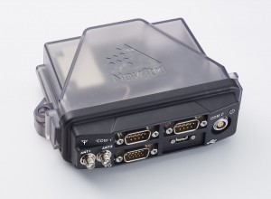
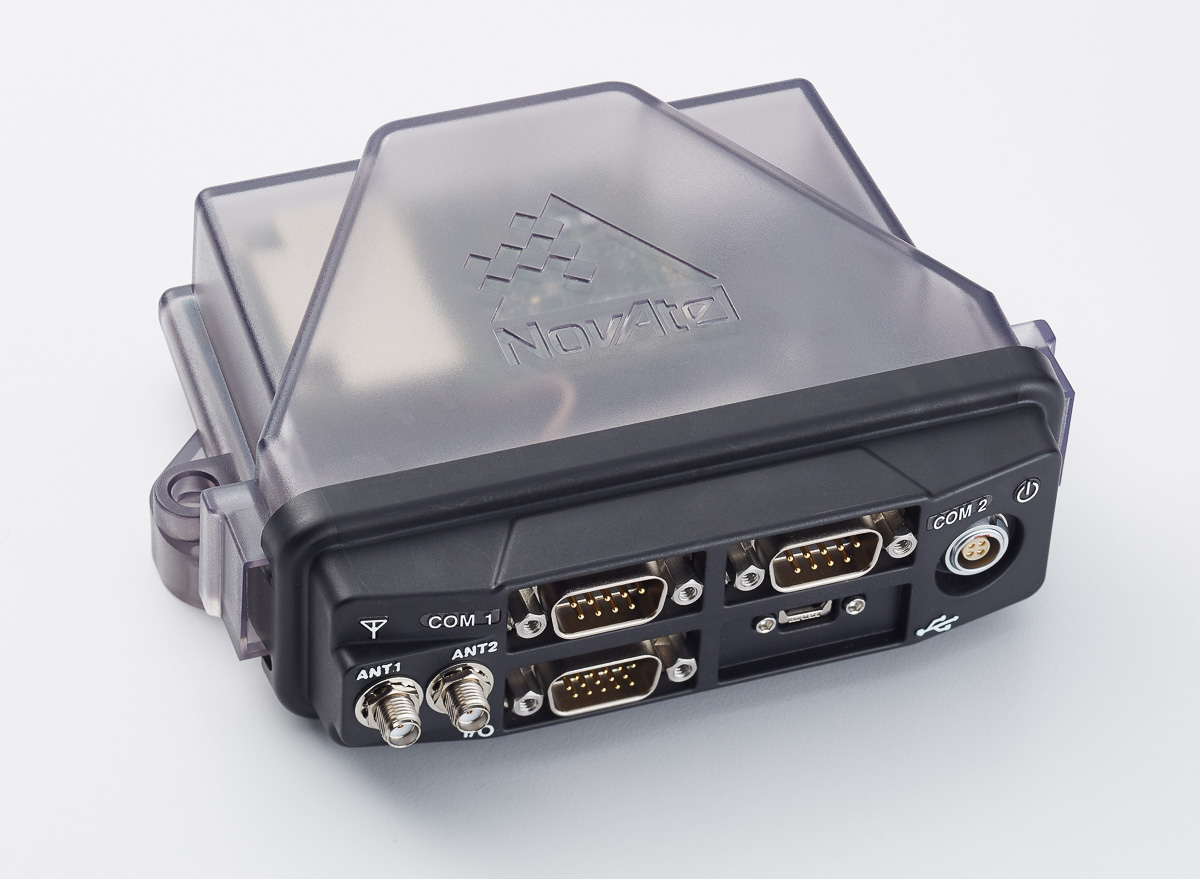
NovAtel’s FlexPak6 enclosed GNSS receiver. The compact FlexPak6 receiver houses NovAtel’s OEM628 triple-frequency plus L-band GNSS receiver board. It tracks all current and future GNSS constellations, with a highly configurable interface designed to meet current and future positioning and integration needs. The FlexPak6 is a GPS and GLONASS receiver that is also Galileo and Compass ready. Upgradable receiver firmware ensures easy updating to future signals. While multi-constellation tracking provides higher solution availability and reliability, its flexible communication interface broadens deployment options. It provides 100-Hz measurements for high dynamic applications. Signals tracked include L1, L2 and L2C and L5. It also has RT-2, ALIGN, GLIDE, RAIM firmware options.
NovAtel, www.novatel.com
Interference mitigation
Single- or dual-antenna receiver with latest algorithms

AsteRx-U dual-antenna receiver. The AsteRx-U receiver incorporates the latest GNSS tracking and positioning algorithms, such as LOCK+ technology to maintain tracking during heavy vibration machine use and IONO+ technology to assure accuracy in regions of elevated ionospheric activity. Interference mitigation counteracts ambient and deliberate RF interference. The AsteRX-U is built around Septentrio’s latest application-specific integrated circuit (ASIC), the GReCo4, and incorporates built-in jamming detection and countermeasures, multipath rejection and fast acquisition. More than 500 hardware channels track all available constellations (GPS, GLONASS, Galileo, Beidou, IRNSS and QZSS).
Septentrio, www.septentrio.com
GNSS/MEMS package
For applications requiring both RTK and orientation
 The Trimble BD935-INS delivers GNSS and inertial technology in an easy-to-integrate form factor for demanding conditions and applications such as lightweight robotic or unmanned vehicles. It features precision GNSS with an integrated 3D micro-electro-mechanical systems (MEMS) inertial sensor package, triple frequency for both GPS and GLONASS constellation, and dual frequency for BeiDou and Galileo. The compact module augments real-time precise positioning with 3D orientation. Connectivity and configuration allow system integrators and OEMs to add GNSS and attitude to specialized or custom hardware solutions. By integrating inertial sensors onto the GNSS module, users receive more robust performance in challenging environments. The module delivers fast and reliable real-time kinematic (RTK) initialization for 1–2 centimeter positioning. The integrated GNSS-inertial engine delivers high-accuracy GNSS and DGNSS positions in challenging environments such as urban canyons, tunnels and heavy canopy.
Trimble, www.trimble.com
555-channel receiver
 Capacity for galileo and other future signals
With its robust 555-channel engine, the new Leica Viva GS16 receiver is empowered by RTKplus to access all known and current signals while intelligently distinguishing which ones are the optimal combination to lock onto for accurate positioning adapting to any environmental conditions. There is also capacity for future signals, such as the full deployment of BeiDou and the expected progress of Galileo and QZSS. Thanks to SmartLink, the precise point-positioning technology, uninterrupted positioning continues even when local corrections services are unavailable due to obstructions or lack of cellular coverage. When no reference data is available, SmartLink continues to enable fully remote work. On a field tablet or controller, users can interact with immersive 3D models directly in the field, ensuring all data is collected and linked to the office.
Leica Geosystems, leica-geosystems.com
SURVEY & MAPPING
Mobile mapping system
 Laser scanner rolls on a trolley
SurphSLAM combines the new Surphaser 10 laser scanner and GeoSLAM’s new RealTime SLAM registration software. SurphSLAM can be used for extremely accurate high-resolution 3D mobile mapping without the need for GPS. The integration of technologies allows for the resulting point cloud to be registered and displayed in real time, facilitating the performance and speed of the survey. Surphaser scanners produce high-accuracy data sets with ultra-low noise levels. The combination of speed, low range noise, sub-millimeter accuracy and reduced size of the scanner make it suitable for a versatile mobile mapping system such as SurphSLAM. The custom-designed trolley is lightweight and collapsible.
Basis Software, www.surphaser.com; GeoSLAM, geoslam.com
GeoPackage support
 OGC GeoPackage enables platform-independent data exchange
TerraGo Edge 3.9.3 features full support for OGC GeoPackage, a universal format for sharing maps and geographic data across mobile devices and platforms. TerraGo Edge enables users to import and export OGC GeoPackage as a SQLite database optimized for performance on iOS and Android devices. Release 3.9.3 closes the loop for a complete GeoPackage collaboration workflow by allowing Edge app users to import GeoPackage data from a mobile device, collect location-tagged field data, and roundtrip the information back to the GIS or other enterprise systems of record.
TerraGo, www.terragotech.com
NTRIP software
Open-source client extended with full galileo support

BNC on a Mac system for static real-time precise point positioning with Google Maps, such as for early warning of natural hazards. Version 2.12 of the BKG NTRIP Client (BNC) real-time software for Windows, Linux and Mac now comes with complete command line interface and considerable post-processing functionality. RINEX Version 3 file editing and quality check with full support of Galileo, BeiDou and SBAS — besides GPS and GLONASS — are also among the new features. BNC version 2.12 allows simultaneous multi-station precise point positioning (PPP) for real-time displacement monitoring of entire reference station networks. Comparison of satellite orbit/clock files in SP3 format is another new feature, along with a large set of examples for various applications. BNC software was originally developed bythe Federal Agency for Cartography and Geodesy (BKG) and Czech Technical University.
BKG GNSS Data Center, https://igs.bkg.bund.de/ntrip/download
Smart antenna
For deformation monitoring
 The Leica GMX910 smart antenna is desgined for static, long-term projects requiring a high number of sensors. It can enable dynamic monitoring with up to 10-Hz data streaming and advanced multi-frequency, multi-constellation tracking. Starting with the basic GPS single-frequency receiver and adding multiple upgradable options, the antenna adapts to a wide range of GNSS monitoring applications, from complex manmade to natural structures. The smallest movements of bridges, dams or high-rise buildings are detected in real-time. The antenna supports multiple GNSS satellite systems and signals, tracking up to 555 channels. An IP67 rating against dust and water, extended temperature ranges and low power consumption enables installation of the device in remote areas and severe conditions.
Leica Geosystems, leica-geosystems.com
UAV
GNSS helix antenna
For disaster monitoring, traffic patrol, security monitoring
 The 25-gram HX-CH6601A GNSS helix antenna for UAV and geospatial applications receives GPS L1/L2, GLONASS L1/L2 and BeiDou B1/B2. It offers exceptional pattern control, polarization purity and high efficiency in a compact form factor. The antenna is equipped with a high-quality, durable IP65 sealed radome housing and terminated with a subminiature version A (SMA) connector, which has high gain and wide beam width to ensure the signal-receiving performance of satellites at a low-elevation angle.
Harxon, www.harxon.com
Collision avoidance
 1.5 gram micro ADS-B receiver
The pingRX ADS-B (automatic dependent surveillance – broadcast) receiver requires 1/100th the power of conventional ADS-B receivers. It implements sense-and-avoid capabilities for small drones operating in the National Airspace. pingRX measures 32 x 15 x 3 millimeters, which is a fraction of the size of earlier units. It receives ADS-B information broadcast by other aircraft on two frequencies approved by the U.S. Federal Aviation Administration (978 MHz and 1090 MHz.) This allows the unit to detect commercial aircraft threats within a 100-statute-mile radius in real time.
uAvioniX, www.uavionix.com
Multirotor System
 Available as turn-key sUAS or as standalone gimbal
The U1 is a professional-grade unmanned aerial vehicle for the industrial survey and surveillance markets, as well as for cinematographers. Features include redundant flight control and battery systems, customized downlink with two high-definition (HD) video feeds, stability even at full zoom with a gyro-stabilized gimbal system, and remote camera control.
Shotover, www.shotover.com
TRANSPORTATION
Dash camera
 Car & Driver branded dash cam includes built-in GPS
The dash camera CDC-601 is equipped with built-in GPS and motion detection. Media shortcut keys allow the driver to manage settings and view their recordings. The camera automatically records when the driver starts the engine and shuts down when the ignition turns off. The 1080p high-definition camera has a 120-degree wide-angle lens, loop recording, time stamp and accident detection. An 8-GB card is included, but it can support up to a 32-GB card.
Summit CE Group, summitcegroup.com
Navigation for underwater vehicles
Tiny inertial navigation system helps propel ROVs

A science ROV being retrieved by an oceanographic research vessel. The Rovins Nano is a new inertial navigation system for the offshore industry. Based on iXBlue’s fiber-optic gyroscope technology, the Rovins Nano is designed for for remotely operated underwater vehicle (ROV) pilots performing maintenance and construction operations. It offers the stability and accuracy of the inertial position, outputting true north, roll, pitch and rotation rates. It can directly transmit the ROV’s position with extreme accuracy because of its integrated INS algorithm capable of collecting acoustic data, regardless of the depth. Rovins Nano adapts itself to the user with easy configuration, installation and use. The goal is for the pilot to forget the existence of the product when maneuvering. Because of its compactness, lightness and open architecture with all third-party sensors, Rovins Nano is easy to integrate into existing ROVs.
iXBlue, www.ixblue.com
CORS for DOTS
New platform optimzed for transportation departments modernizing aging CORS installations
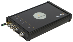
The Septentrio PolaRx5 GNSS receiver. A new PolaRx5 Continuously Operating Reference Station (CORS) platform has been optimized for state departments of transportation (DOTs) and other real-time-kinematic (RTK) network operators. The PolaRx5 is powered by Septentrio’s AsteRx4 next-generation multi-frequency engine. It offers 544 hardware channels and supports all major satellite signals including GPS, GLONASS, Galileo and BeiDou, as well as regional satellite systems such as QZSS and IRNSS. Septentrio’s Advanced Interference Mitigation (AIM+) technology enables the PolaRx5 to filter out both intentional and unintentional sources of radio interference, from narrowband signals over high-powered pulsed signals to chirp jammers and Iridium transmitters. In addition, Septentrio’s patented APME+ multipath mitigation technology guarantees superior measurement quality by eliminating short-delay multipath errors without introduction of bias. The PolaRx5 leverages Septentrio’s web interface and built-in Wi-Fi and Bluetooth interfaces to give users complete control and visibility of the receiver. The user interface integrates into existing network management systems. The web browser provides secure access to all receiver settings and status, data storage and firmware upgrades as well as a built-in spectrum analyzer for system monitoring.
Septentrio Americas, septentrio.com
Analog GPS speedometer
 Classic form for high-tech tracking
The Omata One speedometer displays essential information to cyclists in a classic form. The GPS computer inside the speedometer records with high precision so that cyclists can download their activity data to their preferred training applications or websites. On the outside, Omata One has a legible and mechanical analog movement that shows riders the speed, distance, ascent and time. The product displays only these four core pieces of information so the cyclist can focus on the ride. Omata plans to offer additional GPS speedometers for other sports.
Omata, omata.com
Connected car dongle
Adds LTE, Wi-Fi and cloud-based diagnostics to older cars
 Samsung Connect Auto plugs directly into a car’s OBD II port underneath the steering wheel. It uses real-time alerts to help users improve their driving behavior, including increased fuel efficiency, while offering a Wi-Fi connection for passengers. The connection is kept secure using Samsung KNOX , the company’s mobile security platform. The backbone of Samsung Connect Auto is KNOX security and Tizen OS for interoperability. Developers can leverage Tizen and Samsung’s software development kit (SDK) to further evolve additional services. Samsung also encourages safe driving behavior by using geofencing and driver rating algorithms. In the event of an accident, emergency alerts notify the driver’s contacts, and accident concierge services are provided. A “Find My Car” app also helps in locating a car in real time using LTE and GPS. Samsung Connect Auto will initially be available in the second quarter in the U.S., with AT&T the first wireless provider.
Samsung, www.samsung.com