Tag: autonomous vehicles

  • Drones team with fighter aircraft and help inspect airports

    Drones team with fighter aircraft and help inspect airports

    Additional Loyal Wingman jet-powered drones are being developed. Plus, quadcopters are helping calibrate and maintain aviation ground navigation systems.

    I’ve previously discussed the Loyal Wingman project. Companies in the United States and Australia are developing unmanned full-scale jet-powered drones t0 fly alongside frontline fighters, and perhaps take on riskier missions.

    The Loyal Wingman drones are powered with artificial intelligence developed for the U.S. Air Force Skyborg program.

    Programs in other parts of the world are also developing technology for the same fly-along objectives. The United Kingdom has launched the Lightweight Affordable Novel Combat Aircraft (LANCA) program, and India is working on the Combat Air Teaming System (CATS) Warrior project.

    UK LANCA project

    The UK usually takes its time progressing with new aviation concepts, but has now awarded a £30 million concept contract to Spirit Aerosystems in Belfast to develop and fly a demonstrator drone by the end of 2023.

    Meanwhile, Kratos in the United States and Boeing Australia both have Loyal Wingman UAVs well into flight test programs as part of the Skyborg program. (The first test flight of the Loyal Wingman was successfully completed in February.) Nevertheless, the LANCA schedule should mesh with that of the UK’s next-generation fighter program, known as Tempest, which is just getting started.

    Computer rendering of the United Kingdom’s Mosquito drone concept. (Credit: UK Defense Department)
    Computer rendering of the United Kingdom’s Mosquito drone concept. (Credit: UK Defense Department)

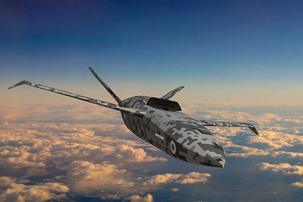
    Spirit Belfast is the Irish subsidiary of Spirit AeroSystems (Wichita, Kansas), previously owned by Bombardier (Montreal, Canada) and, before that, Shorts Brothers, Belfast. Spirit was previously involved in manufacturing aerostructures and will apply its unique composite resin transfer-infusion technology to build a high-speed capable, lightweight fuselage for the aircraft.

    Spirit has formed Team Mosquito, joining Northrop Grumman UK and Intrepid Minds for flight controls and avionics. An engine supplier and developer has yet to be announced.

    CATS Warrior project

    On the other side of the world, Indian state-owned Hindustan Aeronautics Limited (HAL) has apparently invested significantly since at least 2019 in a program to develop another Loyal Wingman concept, known as the HAL Combat Teaming System Warrior (HAL CATS Warrior). A mockup of the CATS Warrior was on display at Aero India 2021.

    While still in the early phase of development, the program appears to be well into the major undertaking by HAL and its partner Newspace R&D. HAL has been the indigenous aircraft manufacturer for the Indian Air Force since the late 1940s, with facilities in Bangalore and with more than 25,000 employees.

    The design goals for the Warrior drone appear to mirror those of the programs in the United States and the United Kingdom — to create an independent, autonomous, unmanned vehicle that can be teamed alongside frontline fighter aircraft as an expendable force multiplier.

    Flight inspection drones

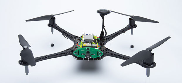
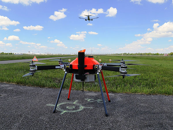
    While we’re on the topic of aviation, let’s pull back to more current unmanned applications. News has emerged of a drone being used to inspect a landing-aid system in Russia. Aviation authorities in many countries spend lots of time and money on verifying and calibrating new and existing ground-based landing and navigation aids, to the point of equipping general aviation aircraft with extensive instrumentation and dedicating them to regularly checking key airport and en-route systems.

    This is an expensive and lengthy task — all the way from buying, maintaining and operating aircraft to equipping each flying laboratory and maintaining complex onboard equipment, as well as training and employing skilled pilots and equipment operators.

    The Cursir nav-aid inspection drone. (Photo: Cursir)
    The Cursir nav-aid inspection drone. (Photo: Cursir)

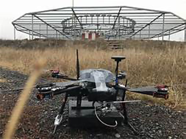
    Cursir in Russia has installed a specialized radio receiver on a commercial drone and used it to pre-configure a newly installed instrument landing system (ILS) at the Ulyanovsk-Vostochny airport, where difficult terrain makes the initial set-up of the ILS quite complex.

    However, by using this calibration drone, set-up time was significantly reduced and adequate preparations were made for subsequent control flights by a fully equipped flight inspection aircraft. Even though these formal flights were still required, calibration of the ILS was less involved and fewer flights were necessary.

    In the future, maintenance checks using only the calibration drone may be possible. Drones have also been in use for complete NAVAID inspection for some time, with companies including Canard in Spain and Colibrex in Germany.

    Canard’s drones undertake flight inspection of runway lighting, ILS and other airport NAVAIDS. It uses a database of airports, runways and systems for flight planning, autonomous drone operations and analysis/reporting of collected data. Canard was founded in 2015, and its first flight inspection contract was in 2017 for seven European airports.

    The Canard flight inspection drone. (Photo: Canard)
    The Canard flight inspection drone. (Photo: Canard)

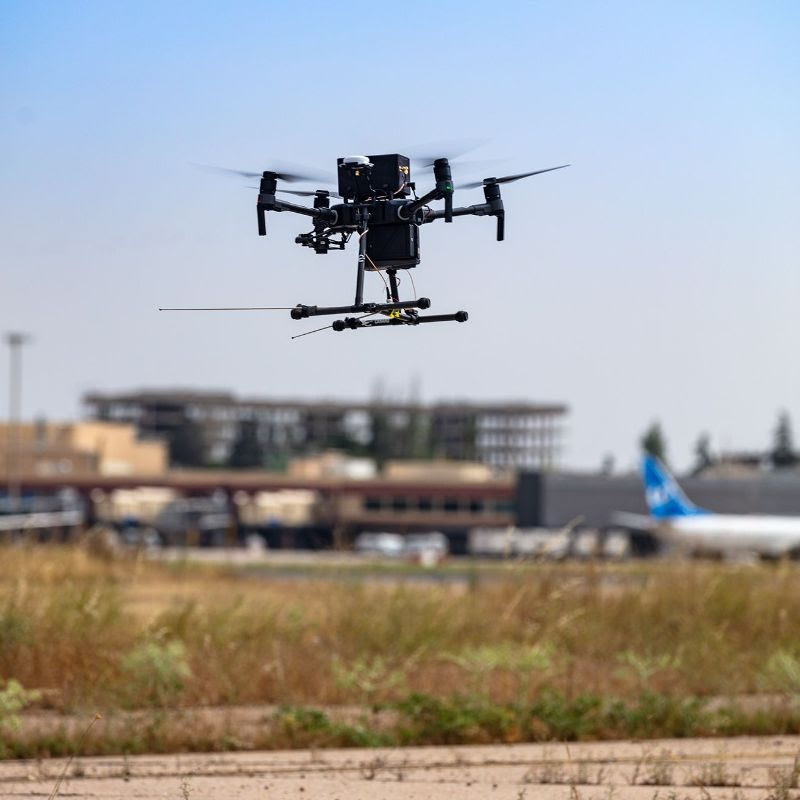
    Colibrex built its own COL-X8 NavAidDrone in order to better integrate its in-house flight inspection receivers and antennas. The requirement for flight inspection is to accurately evaluate the signal-in-space being transmitted by the NAVAID, so Colibrex invested heavily in the development of its on-board RF reception and in-house results analysis systems. Early trials were first run in 2012, through many different measurement campaigns around the world; Colibrex has now established an extensive drone flight inspection capability.

    The Colibrex NAVAID drone. (Photo: Colibrex)
    The Colibrex NAVAID drone. (Photo: Colibrex)

    To sum up, more Loyal Wingman jet-powered drones are in development, and perhaps we now have a little insight into how quadcopters are being used to calibrate and maintain aviation ground navigation systems. These are just a couple more innovative applications for unmanned aircraft.

    Tony Murfin
    GNSS Aerospace

  • Qualcomm launches 5G, AI-enabled drone platform

    Qualcomm launches 5G, AI-enabled drone platform

    The Qualcomm Flight RB5 5G platform accelerates and scales development for drone manufacturers to deliver powerful enterprise and industrial 5G drones

    Qualcomm Technologies has unveiled a drone platform and reference design that offers both 5G and artificial intelligence capabilities.

    The Qualcomm Flight RB5 5G platform is designed to accelerate development of commercial, enterprise and industrial drones. Powered by the Qualcomm QRB5165 processor, it builds upon Qualcomm Technologies’ latest offerings for the internet of things, delivering a solution that will drive the next generation of high-performance, low-power, 5G drones, the company said.

    As a primary driver of global 5G proliferation, Qualcomm Technologies has enabled 5G to scale for both the drone and robotics industries. The new 5G platform condenses multiple complex technologies into a tightly integrated drone system. Use cases include mapping, inspection, film and entertainment, defense, security and emergency response, and delivery.

    Photo: Qualcomm
    Photo: Qualcomm

    The Qualcomm Flight RB5 5G Platform’s high-performance and heterogeneous computing at ultra-low power consumption provides power efficient inferencing at the edge for AI and machine learning (ML), enabling fully autonomous drones, the company said. New camera capabilities deliver premium image capabilities and performance.

    With 5G and Wi-Fi 6 connectivity, this platform enhances critical flying abilities beyond visual line-of-sight (BVLOS) to support safer, more reliable flight. In addition, safety controls alone can no longer assure industrial and commercial drone safety, especially when scaling to Beyond Visual Line of Sight operations.

    The Qualcomm Flight RB5 5G platform is equipped with a Qualcomm Secure Processing Unit to support modern drone demands for cybersecurity protections as a key enabler of data-protection and safety requirements.

    Partners. Qualcomm Technologies is working with Verizon to complete network testing of the Qualcomm Flight RB5 5G Platform for the Verizon 5G network, and expects the platform, which is 5G mmWave capable, will be offered via the Verizon Thingspace Marketplace.

    The Qualcomm Flight RB5 5G drone reference design is available now for pre-sale through ModalAI. A development kit is expected to be available this year in the fourth quarter.

    “We have continued to engage many leading drone companies, enabling 200+ global robotics and drone ecosystem members in addition to consistently driving and promoting worldwide drone standardization and transformative 5G capabilities in organizations such as 3GPP, GSMA, the Global UTM Alliance, the Aerial Connectivity Joint Initiative (ACJA) and ASTM,” said Dev Singh, senior director, Qualcomm Technologies.

    In addition, global carriers and IoT ecosystem who have validated or expressed support for the drone platform include Asia Pacific Telecom, AT&T, China Unicom, Everguard.ai, FlightOps, Juganu, KT Corporation, LG Uplus, MITRE, ModalAI, Taiwan Mobile, TDK, Veea, Verizon Skyward and Zyter.

  • AUVSI Xponential takes over Atlanta

    AUVSI Xponential takes over Atlanta

    Logo: AUVSI Xponential 2021

    The Association for Unmanned Vehicles Systems International (AUVSI) brings its annual conference, XPONENTIAL, to Atlanta, Aug. 16-19. The event invites industry changemakers and end users to experience new technology that is solving real world problems, from safety and defense, to energy and infrastructure, business, construction, health, and the environment. The convention features keynote speakers, panel presentations, educational programs, specialized workshops, networking opportunities, and an exhibitor hall featuring newly developed technology to preview.

    “To support our community and these technologies as they continue to accelerate along the innovation curve, our theme this year is Assured Autonomy,” said Brian Wynne, President and CEO of AUVSI. “As an industry, we must work together to ensure these systems are created, deployed, marketed and regulated to create a virtuous cycle of trust, social benefit, and economic growth. You’ll see that focus throughout our programming on-site, as well as in the technologies and operational services on display from our exhibitors.”

    XPONENTIAL typically attracts 8,000+ attendees each year, who attend 100+ educational sessions organized by tracks focused around technology, policy, and public acceptance. The Solutions Theatre features the top experts in their field sharing best practices, technical discoveries and announces the AUVSI XCELLENCE Award winners. The Startup XCELERATOR Pavillion serves as a hub for emerging technologies and early-stage companies providing a glimpse into the industry’s future. Meanwhile, the XPO Hall provides access to more than 450+ companies all showcasing the latest breakthroughs in drones, robotics, and other unmanned systems.

  • Sky Power and UAS Global Services present two new helicopters

    Sky Power and UAS Global Services present two new helicopters

    The Sicura EG-1100 (left) and Anzen EG-1250 with Sky Power engines are being exhibited at AUVSI Xponential. (Photo: UAS Global Services)
    The Sicura EG-1100 (left) and Anzen EG-1250 with Sky Power engines are being exhibited at AUVSI Xponential. (Photo: UAS Global Services)

    German engine manufacturer Sky Power GmbH is presenting its UAV engines at this year’s AUVSI Xponential show in Atlanta, Georgia. Plus, new Sky Power customer UAS Global Services of Texas will present two new helicopters, which are powered by different engines from Sky Power.

    UAS Global Services will introduce its Anzen EG-1250 helicopter at the show. The Anzen EG-1250 is a heavy-lift, long-range, multi-purpose Group 3 platform. The helicopter will significantly expand UAS Global Services’ service as well as operational support offerings. Basic specifications include a maximum takeoff weight of 250 pounds (113 kg), a maximum flight time of up to 6 hours, a payload capacity of 75 pounds (34 kg), a cruising speed of 65 kts, and all-weather day and night capability.

    The “EG” in the Anzen EG-1250 designation stands for a dual engine configuration consisting of electric and internal combustion propulsion. The main engine is Sky Power’s SP-180 SRE Wankel engine, while the secondary engine is a NeuMotors 12030/5.5. This 30KW electric motor can power the aircraft or serve as a power amplifier in combination with the SP-180 SRE. In addition to the added power and safety provided by the two motors, the Anzen EG-1250 is autorotatable and offers an optional safety parachute system.

    UAS-GS was contracted by Ireland-based UAV Evolution Ltd. to develop the dual-rotor platform. After more than 5 years of development, the versatile design allows for a variety of engine, payload and operational options. The platform flexibility allows the Anzen EG-1250 to support a wide range of customers in the marine, agricultural, oil and gas, utility, cargo transport, security and other application sectors.

    UAS Global Service’s second helicopter is the Sicura EG-1100, which is the third generation of the internally developed single-rotor helicopter. This flight system has become the workhorse of the UAS Global Services fleet in recent years and is now available to external customers. Basic specifications include a maximum takeoff weight of 55 lbs (25 kg), a flight time of up to 3.5 hours using an internal combustion engine or a flight time of 1 hour in electric mode, a payload capacity of 15 lbs (7 kg), a cruise speed of 55 kts, and a takeoff wind speed of 25 kts.

    The EG-1100 is available with both electric and internal combustion engines. The combustion engine is Sky Power’s powerful and efficient SP-110 TS ROS two-stroke engine, which has been specially tuned and modified to the flight system. The result is competitive flight performance characterized by stable performance under severe environmental conditions, exceptionally stable flight, and immediate flight response during imaging and LiDAR operations.

    With the EG-1100’s considerable payload capacity, customers can implement various transportation tasks in one mission. Different sensor and camera systems can be integrated simultaneously in the Sicura EG-1100, enabling multiple data-acquisition applications in a single flight. This significantly increases the efficiency of the overall UAS mission and provides the customer with timely, cost-effective and high-quality results.

    For more information, visit UAS Global Services at the AUVSI show in Atlanta, booth 2498 or visit Sky Power at booth 2641.

  • Parrot, Verizon and Skyward bring 4G-connected drone to US

    Parrot, Verizon and Skyward bring 4G-connected drone to US

    Photo: Verizon
    Photo: Verizon

    The Parrot ANAFI Ai is powered by Verizon 4G LTE and integrated with Skyward software to pave the way for near real-time data transfer, remote deployment and beyond-visual-line-of-sight (BVLOS) flight operations.

    Verizon, Parrot and Skyward have entered a partnership to bring an out-of-the-box 4G LTE connected drone to the United States.

    The Parrot ANAFI Ai is an off-the-shelf drone that connects to Verizon’s 4G LTE network. Verizon 4G LTE connectivity is provided exclusively to Skyward subscribers at no additional cost. The Skyward Connected Drone Solution gives enterprises one complete experience for planning, flying, data transfer and processing data.

    The Parrot ANAFI Ai professional drone is open to developers with a full open-source app, autonomous one-click photogrammetry and new levels of cybersecurity. Combined with the Skyward Connected Drone Solution, the ANAFI Ai makes complex missions simpler, safer and quicker in photogrammetry, mapping, modeling in construction, infrastructure, inspection, surveying, public safety and enterprise.

    The drone features an omni-directional obstacle-avoidance system, 48 MP imaging accuracy, 4K 60 fps smooth videos, and up to 32 minutes of flight time in an airframe that weighs less than 2 pounds.

    Parrot ANAFI Ai’s embedded Secure Element secures the 4G LTE link between the drone and the user’s device. Parrot’s streaming software quickly optimizes the definition and frame rate for the connected 4G network.

    Parrot ANAFI Ai pilots can subscribe to a paid account or a free trial of the Skyward Connected Drone Solution to:

    • plan with Skyward’s airspace map and fleet management tools
    • obtain fast, automated access to controlled airspace from the Federal Aviation Administration with LAANC
    • fly over Verizon 4G LTE with the Skyward InFlight mobile app
    • process with Skyward Mapping & Modeling, powered by Pix4D
    • transfer data during flight over 4G LTE.

    Users can activate 4G LTE connectivity in a few taps exclusively in the Skyward InFlight mobile app. Once activated, the connectivity provides a seamless backup connection to the flight controller in case of interference or interruption. It paves the way for near real-time data transfer, remote deployment and BVLOS flight operations, allowed with a waiver from the FAA.

    “Enterprise drone programs are pushing the limits of technology available today and advanced operators are ready for a connected, trusted and capable drone to take their drone programs to the next level,” said Mariah Scott, Head of Verizon Robotics Business Technology. “Parrot ANAFI Ai connected to Verizon 4G LTE marks an industry milestone toward distributed, remote, persistent operations that lets users fly to anywhere from anywhere with near real-time data transfer.”

    “Cellular connectivity is the new communications standard for the professional drone industry and Parrot ANAFI Ai seeks to set new standards for drones at work” said Henri Seydoux, Founder and CEO of Parrot.  “We designed ANAFI Ai’s 4G LTE connectivity, which enables precise, robust and secure control at any distance with a 4G LTE connection that avoids obstacles. Advanced artificial intelligence, autonomous flights, best-in-class imaging, photogrammetry accuracy and reliable 4G LTE connectivity on the Verizon network, put powerful new tools in the hands of professionals like never before and we truly believe it is a game changer for the professional drone industry.”

    The Skyward Connected Drone Solution with Parrot ANAFI Ai on Verizon 4G LTE will be available in the second half of 2021 through Skyward.

  • WingtraOne GEN II debuts for professional VTOL flights

    WingtraOne GEN II debuts for professional VTOL flights

    A new vertical-takeoff-and-landing (VTOL) drone — the WingtraOne GEN II — is now available. The GEN II offers industrial reliability and mapping versatility with an oblique camera configuration for high-quality 3D drone-mapping data capture.

    Drone maker Wingtra spent six years developing the GEN II, and tested it over 100,000 flights. Its WingtraOne is being used by professionals worldwide across many industries.

    According to Wingtra, the GEN II represents a solid step forward in industrialization and reliability along with new perks that push the previous limits of commercial mapping drones.

    The WingtraOne GEN II. (Photo: Wingtra)
    The WingtraOne GEN II. (Photo: Wingtra)

    Oblique 3D Mapping Payload

    “We wanted to make the WingtraOne drone even more versatile for our customers. So next to our flagship 42MP Sony RX1, we’re including new, high-end mapping payloads,” said Maximilian Boosfeld, co-founder and CEO of Wingtra. “I’m especially excited to announce our oblique solution, which offers outstanding 3D mapping results. It’s the perfect choice for capturing infrastructure — from a single industrial plant to entire cities.”

    WingtraOne’s GEN II oblique mapping solution is backed by signed partnership agreements with Bentley Systems and Esri. To demonstrate the power of GEN II carrying its Oblique Sony A6100 payload, the Wingtra team mapped the city of Zurich, Switzerland, in six flight hours, producing a 3D model processed with both Bentley ContextCapture and Esri’s Site Scan for ArcGIS. Bentley and Esri’s software are both recommended for processing Wingtra oblique datasets.

    “Bentley Systems is delighted to partner with Wingtra to transform high-resolution oblique imagery from WingtraOne drones into 3D reality meshes — an ideal starting point for infrastructure digital twins,” said Phil Christensen, VP, Industry Solutions, iTwin Context, Bentley Systems. “This enables our common users to perform analytics on the resulting models as well as leverage Bentley’s iTwin platform to share performant, city-scale digital twins.”

    “Our partnership with Wingtra unlocks new capabilities for Site Scan for ArcGIS users by allowing them to create wide-scale and accurate 3D meshes leveraging the oblique payload on the WingtraOne Gen II,” said Richard Cooke, director of Global Business Development at Esri. “These high-resolution images processed through Site Scan produce an enriched 3D GIS for our users who require modelling of open-pit mines, accurate construction updates, creation of digital twins for cities, and more.”

    Digital twin of Zurich mapped with the WingtraOne GEN II drone. (Image: Wingtra)
    The WingtraOne GEN II drone was used to map Zurich and create a digital twin of the city. (Image: Wingtra)

    Integrated PPK and Self-Diagnosis

    WingtraOne GEN II features post-processed kinematic (PPK) ability integrated on every drone, including multispectral Altum and RedEdge payloads, as well as advanced fail-safe and self-diagnosis algorithms and services for dependable operations.

    “We have studied over 100,000 flights and all incoming customer reports to understand what the limits might be so we can push them further,” said Julian Surber, Wingtra product manager. “As a result, we’ve designed many reliability tools for GEN II to guarantee uninterrupted operations.”

    Wingtra’s engineering team has redesigned the electronics of the GEN II from its predecessor WingtraOne for increased reliability, including a more powerful onboard computer, optimized PCB designs, and a new navigation and heading unit developed inhouse.

    The GEN II runs through health-monitoring algorithms for motors, servos, batteries, camera, PPK and onboard sensors, health self checks that minimize the potential of flight  with unsafe equipment.

    Precision Agriculture Boost

    Wingtra’s top-of-the-line multispectral payloads Micasense Altum and RedEdge will now be paired with high-accuracy PPK, which improves the quality of multispectral insights for uses such as irrigation management and prescription maps for pesticides.

  • uAvionix receives FAA order for certified drone GPS receiver

    uAvionix receives FAA order for certified drone GPS receiver

    The truFYX receiver. (Photo: uAvionix)
    The truFYX receiver. (Photo: uAvionix)

    uAvionix Corp. has received a Technical Standard Order (TSO) from the U.S. Federal Aviation Administration (FAA) for its truFYX GPS receiver for unmanned aircraft systems (UAS).

    Capable of receiving satellite-based augmentation system (SBAS) and wide area augmentation system signals, the receiver specifically targets UAS platform navigation and surveillance solutions.

    With an increased regulatory focus on certifiability of UAS for beyond visual line of sight (BVLOS) operations, truFYX provides a critical component to enable safe navigation and airspace integration. A uAvionix’s blog article — “Why Certified GPS with Integrity for UAS Navigation Matters” — describes the importance of GPS receivers for UAS BVLOS operations.

    The TSO-C145e Class Beta 1 GPS weighs 20 grams, which includes the receiver, antenna, DO-160G power supply and interface protection circuits. A Class Beta 1 GPS enables the truFYX to be the primary position source for domestic enroute and terminal navigation, as well as the primary position source for ADS-B OUT solutions.

    The Source Integrity Level 3, System Design Assurance 2 system ensures reception and processing by Air Traffic Control and Traffic Collision Avoidance System when used as a position source for ADS-B. For these reasons, the Airbus Zephyr program was announced as a truFYX launch customer in January.

    A certified position source for UAS navigation reduces position error by implementing a strict Receiver Autonomous Integrity Monitoring (RAIM) / Fault Detection and Exclusion (FDE) engine, and processing advanced SBAS messages designed to improve accuracy and integrity. These systems combine to detect unhealthy GPS satellite transmissions and remove them from the position calculation, providing critical differentiation from a typical commercial GPS receiver.

    Design Assurance Level C software and hardware is achieved through the use of RTCA DO-178C and DO-254 engineering processes. As with all uAvionix TSO certified avionics, truFYX is manufactured in Montana under an FAA Manufacturing Inspection District Office approved quality-control process and facility.

    truFYX technology has been previously TSO-certified in several form factors, including the highly integrated and complex skyBeacon, tailBeacon and tailBeaconX platforms.

  • DroneShield counter-UAS products head to Australia, Brazil

    DroneShield counter-UAS products head to Australia, Brazil

    Counter-unmanned aircraft system (C-UAS) company DroneShield has sold its RfOne MKII long-range sensors to the Australian Army. The capability is being delivered immediately to allow the Australian Army to assess its future counter-drone requirements and options, the company said.

    “As an Australian company, DroneShield is immensely proud to support the Australian Army with its long-range counter-drone strategy, said DroneShield CEO Oleg Vornik.

    Deployment of the long-range sensors will highlight the flexibility, resilience and capabilities of DroneShield equipment in a dynamic field environment, while also assisting the Australian Army in establishing its counter-drone requirements and future capability options.

    The sale, announced July 19, was structured as a one-off sale to the Australian Army. Similar to the standard purchases from DroneShield’s other defence and law enforcement customers, comprises a small purchase of equipment.

    Australian counter-unmanned aircraft system (C-UAS) company DroneShield has sold several of its RfOne MKII long-range direction-finding sensors to the Australian Army. The deal, announced July 19. and will “allow the Australian Army to assess its future counter-[UAS] requirements and options”, DroneShield said in a statement, as well as equipping existing platforms with the sensors.

    Brazilian Sale

    DroneShield also has received formal approval from Anatel, the Brazilian National Telecommunications Agency responsible for issuing the concession of new radio frequencies. Following approval earlier this month, the company has sold a quantity of its DroneGun Tactical units to the Brazilian government.

    “Brazil is a large and sophisticated market for military and security equipment, and we are pleased to commence active presence in the country, deploying equipment to the customers,” Vornik said. “We look forward growing our presence in Brazil with the urgent counter-drone requirements mirroring what we are seeing in other countries.”

    New Kit

    Immediate Response Kit. (Photo: DroneShield)
    Immediate Response Kit. (Photo: DroneShield)

    DroneShield also released its Immediate Response Kit (IRK), a rapidly deployable C-UAS detection and defeat kit. The IRK consists of an RfPatrol portable (1.2 kg/2.6 lbs incl battery) detection device and a DroneGun MKIII (2.1 kg/4.7 lbs including battery) defeat device in a rugged carry case.

    Both RfPatrol and DroneGun MKIII are currently fielded by military and government customers globally.

  • Brazil approves SenseFly eBee X for BVLOS operations

    Brazil approves SenseFly eBee X for BVLOS operations

    Brazil’s Civil Aviation Authority approves  Flagship Fixed-wing Drone 

    The eBee X. (Photo: senseFly)
    The eBee X. (Photo: senseFly)

    The National Civil Aviation Agency (ANAC) of Brazil has approved beyond-visual-line-of-sight (BVLOS) flights using SenseFly‘s flagship eBee X fixed-wing drone.

    ANAC’s decision means that the senseFly eBee X is officially approved for use in future BVLOS missions carried out by Brazilian drone operators. The drone received approval by demonstrating the safety requirements of the ANAC RBAC-E 94 Regulation for Unmanned Aircraft, through detailed engineering analyses and in-depth flight testing. Sensefly worked in collaboration with drone engineering and consulting specialists AL Drones and geotechnology company Santiago & Cintra.

    Following the certification, senseFly eBee X operators in Brazil now only require a CAER (Special Airworthiness Certificate for RPA) waiver for the aircraft with Santiago & Cintra before flying BVLOS operations.

    “The commercial drone industry in Brazil has been growing at a phenomenal rate. and we’re excited that the senseFly eBee X is at the forefront of these regulatory developments,” said Pierre-Alain Marchand, regulatory compliance manager, senseFly. “BVLOS is becoming an important tool for operators as they start to explore the potential of more advanced drone operations, and we’re pleased that our technology continues to help define frameworks and legislation in the country. Historic approvals passed in recent years has shown us that Brazil is one of the countries to watch for drone commercialization, so continue to watch this space!”

    The authorization comes following approval of senseFly’s proprietary drone technology in 2017, where the use of drones for civil applications in Brazil were legislated as part of the RBAC-E94 regulation. SenseFly drones became the first and only in the country permitted to fly 400 feet in height with a 5 kilometer radius from a licensed pilot or observer, in contrast to previous VLOS operations that restricted use of drones to a 500-meter radius.

    “The authorization of senseFly’s eBee X for BVLOS operations is another step towards commercialization of the sector,” said André Arruda, co-founder of AL Drones. “After years of collective hard work and effort from all parties, this certification presents a real opportunity for operators in the future to expand their mapping operations and achieve a robust return-on-investment. We look forward to seeing what this means for BVLOS operations in Brazil in the coming years.”

    SenseFly’s eBee X fixed-wing drone is designed to suit a wide range of mapping jobs. At 1.6 kg (3.5 lbs.), eBee X is a lightweight, portable solution that is easy for a single person to operate. With an Endurance Extension option enabling a flight time of up to 90 minutes and single-flight coverage of up to 500 ha at 122 m (1,236 A at 400 ft.), the eBee X drone that offers users the high precision of on-demand RTK/PPK for achieving absolute accuracy down to 1.5 cm (0.6 in) without ground control points. This capability makes the eBee X suitable for BVLOS operations such as long corridor mapping missions for utility companies, expansive crop scouting in agriculture and by enterprise customers who desire a robust and professional drone fleet.

  • Skyward and FAA to test cellular-connected drones

    Skyward and FAA to test cellular-connected drones

    A Censys Technologies Sentaero equipped with a Verizon 4G/LTE link. (Photo: Skyward)
    A Censys Technologies Sentaero equipped with a Verizon 4G/LTE link. (Photo: Skyward)

    Skyward, A Verizon company, has signed a Memorandum of Agreement (MOA) with the U.S. Federal Aviation Administration (FAA) to test cellular-connected drones. Cellular-connected drones could unlock complex operations like beyond visual line of sight (BVLOS), universal traffic management (UTM) and one-to-many operations.

    Titled “Unmanned Aircraft Systems (UAS) — Cellular Technologies to Support UAS Activities,” the MOA enables Skyward and the FAA to mutually research the capabilities of cellular communication networks for command and control (C2) within the National Airspace System.

    Partially focused on safety-critical C2 data, the three-year MOA also allows the two groups to propose standards for operations, including BVLOS and over commercial wireless spectrum. Skyward and Verizon will also be using the data and information collected in the course of the MOA to inform its discussions on C2 and BVLOS operations in the FAA’s BVLOS Advisory and Rulemaking Committee.

    Today, most commercial drones use unlicensed spectrum, which is restricted in range and subject to interference, limiting its use for complex operations. Verizon’s 4G LTE nationwide coverage, provided over spectrum protected from interference, presents an enormous opportunity for drone operations.

    The MOA will inform regulations regarding spectrum used in the C2 link between the drone operator and drone. The MOA will also facilitate information sharing between the FAA and Skyward as the parties continue to explore how wireless networks can support drone operations.

    The MOA is inspired by the previous industry collaborations with the FAA, but is intended to address complex UAS operations through joint data collection and analysis.

    The agreement also follows Skyward’s announced emergency waiver to inspect critical communications infrastructure near the Big Hollow wildfire in Washington in September 2020. The industry’s first known fully remote BVLOS operation with no pilot or visual observer on site demonstrated low-risk operation as well as a need for analyzing and sharing fully remote data with standard bodies and the FAA.

    “Cellular-connected drones play a critical role in enabling tomorrow’s safe, reliable and secure drone operations,” said Matt Fanelli, Director of Strategy and Operations at Skyward. “We are thrilled to be laying this foundation with the FAA and are confident that our efforts will help inform technical standards from which industry regulations authorizing low-risk BVLOS and one-to-many operations will flow.”

  • Parrot’s new ANAFI Ai UAV drone is 4G connected

    Parrot’s new ANAFI Ai UAV drone is 4G connected

    Photo: Parrot
    Photo: Parrot

    Drone-maker Parrot has released a new drone for professionals. The ANAFI Ai UAV uses 4G as its main data link between the drone and the operator, so that users will no longer experience transmission limitations.

    The 4G also enables precise control at any distance. For beyond-visual-line-of-sight (BVLOS) flights, it stays connected even behind obstacles.

    For the first time, ANAFI Ai embeds a secure element in the drone and in its Skycontroller 4. The 4G link between the drone and the user’s phone is encrypted. The secure element protects both the integrity of the software and the privacy of data transferred.

    Parrot’s piloting application is open source. Parrot offers developers a software development kit (SDK) to create custom code for the drone to execute during flight. The SDK gives access to all flight sensors, including obstacle-avoidance sensors, occupancy grid and internet access.

    ANAFI Ai’s obstacle-avoidance system detects obstacles in all directions, using stereo cameras to sense objects and automatically avoid them.

    ANAFI Ai incorporates a 48MP main camera and a powerfully stabilized 4K 60-fps/HDR 10 camera to capture finely detailed aerial images and smooth video footage.

    ANAFI Ai will be available in the second half of 2021 through Parrot Drone Enterprise Partners and Enterprise Drone Reseller Network.

  • Maxtena adds M9HCT-A-SMA multi-band GNSS antenna to helical family

    Maxtena adds M9HCT-A-SMA multi-band GNSS antenna to helical family

    Advanced multi-frequency antenna shaped for high-precision applications featuring L-band corrections

    Photo: Maxtena
    Photo: Maxtena

    Maxtena Inc. has introduced an advanced, tiny, patented GNSS antenna for high precision and autonomous multi-frequency applications. The M9HCT-A-SMA antenna is a high accuracy, multi-frequency active helix GNSS antenna + L-band corrections services.

    The design provides simultaneous GNSS reception in a rugged, compact, and ultra-lightweight form factor on:

    • L1: GPS, GLONASS, Galileo, Beidou
    • L2: GPS L2C, Galileo E5B, GLONASS L3OC
    • L5: GPS + L-band corrections

    The M9HCT-A-SMA is suitable for high-precision applications such as the UAV market, where high performance and low weight are driving features in antenna selection.

    The active helix design features Maxtena’s patented compact and lightweight Helicore technology. This technology provides excellent pattern control, polarization purity and high efficiency in a compact form factor.

    The M9HCT-A-SMA is ground-plane independent and offers extremely low power consumption and minimal phase-center variation over azimuth crafted for high-precision applications. The antenna offers superb axial ratio, ensuring multipath error is mitigated.

    For the embedded version, Maxtena provides support for installation and integration of the embedded antenna to offer an exceptional antenna performance. Maxtena can embed the antenna in any housing, then tune the antenna to match the housing’s materials, electronics, and space

    “The M9HCT-A-SMA combines all lower and upper GNSS bands including L1/L2/L5 across all constellations and features L-band corrections,” said Maxtena’s Chief Commercial Officer Vanja Maric. “At the same time, this antenna is the smallest solution with such a performance on the market. The superb axial ratio and multipath rejection allow the antenna to operate in the most RF noisy environments. We see a trend of higher accuracy demand across various industries from autonomous vehicles and robotics to commercial products such as lawn mowers and robotics using our antenna solution.”