China successfully sent twin BeiDou navigation satellites into space on Aug. 25, aboard a single carrier rocket, according to news reports. The satellites are numbers 35 and 36 in the BeiDou navigation constellation.
Tag: China
-
China launches yet more BeiDou navigation satellites
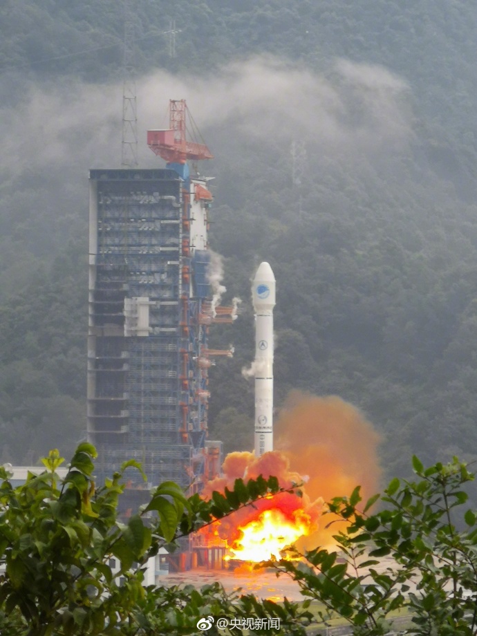
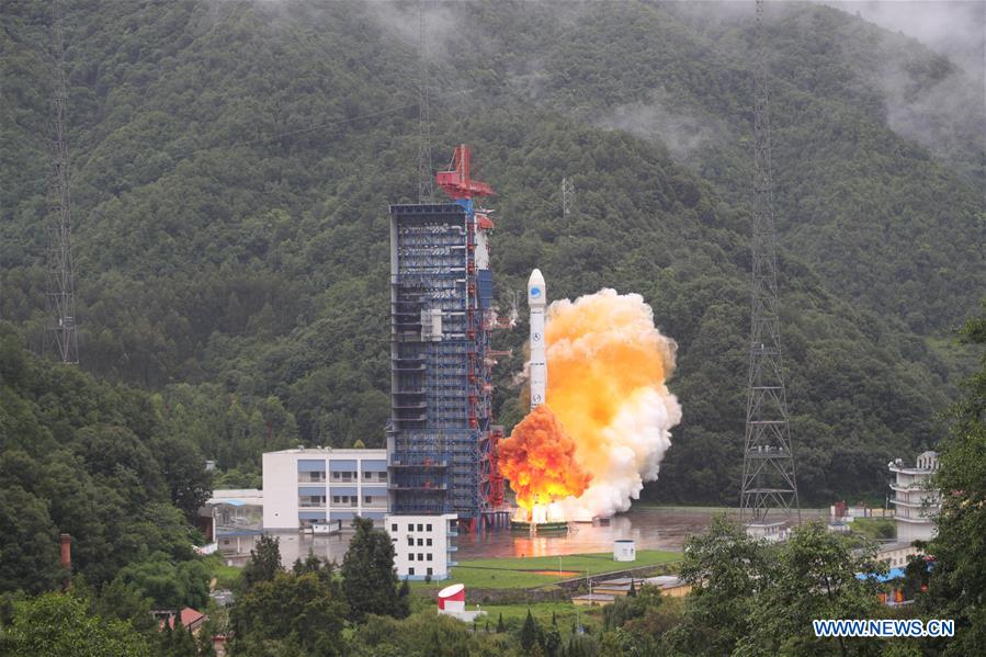
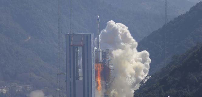
China sends twin BeiDou-3 navigation satellites into space on a single carrier rocket from Xichang Satellite Launch Center in Xichang, southwest China’s Sichuan Province, Sept. 19, 2018. (Photo: Xinhua/Liang Keyan) On Sept. 19, China successfully sent twin BeiDou-3 navigation satellites into space on a single carrier rocket, according to state news agency Xinhuanet.
This is the third launch of twin BeiDou-3 satellites in less than eight weeks. China launched two more pairs of BeiDou navigation satellites into space on July 29 and Aug. 25.
The Long March-3B carrier rocket lifted off from the Xichang Satellite Launch Center at 10:07 p.m. It was the 285th mission of the Long March rocket series.
The twin satellites are the 37th and 38th editions of the BeiDou navigation system. After a series of tests and evaluations, they will work together with 12 BeiDou-3 satellites already in orbit.
The twin satellites will provide danger alerts and navigation services for global users. A basic system with 18 orbiting BeiDou-3 satellites will be in place by the end of the year, which will serve countries participating in the Belt and Road Initiative.
The satellites and the rocket for Wednesday’s launch were developed by the China Academy of Space Technology and the China Academy of Launch Vehicle Technology, respectively.
-
Qualcomm, Qianxun and Quectel to develop precise positioning for Chinese automakers
New high-precision GNSS solution is designed to support connected navigation, LTE-V2X and autonomous driving capabilities in China.
Qualcomm Technologies, Qianxun Spatial Intelligence and Quectel Wireless Solutions have announced a comprehensive high-precision positioning GNSS solution for China’s automotive industry.
This announced version of Qualcomm Technologies’ precise positioning framework supports single-frequency GNSS utilizing real-time kinematic (RTK) technology based on the GNSS receiver built into Qualcomm Snapdragon LTE modems and Qianxun SI’s precise positioning technology — all integrated in an automotive-grade LTE module provided by Quectel.
Using Qualcomm 3D dead-reckoning technology, the precise-positioning framework will enable automakers with a comprehensive 3D navigation solution combining multi-constellation GNSS precise positioning, inertial measurement units and other sensors to support next-generation vehicle capabilities, the companies said.
Capabilities include high-performance connected navigation as well as LTE-V2X vehicle-to-everything communications (also referred to as C-V2X PC5 across the globe) for enhanced road safety, improved traffic efficiency and autonomous driving.
Qualcomm Technologies’ precise positioning framework is designed to facilitate open-sky positioning performance from up to 3 meters to less than 1 meter, supporting lane-level positioning and potentially achieving accurate locations from a centimeter to a few decimeters when combined with select third-party GNSS correction services.
This framework is also designed to support a safer and convenient automated driving experiences (level 2 and above), as well as LTE-V2X applications based on positioning, velocity and heading information. Integrated into telematics modules based on the Snapdragon LTE modems, the precise positioning framework supports a cost-effective solution for automakers already including cellular connectivity into their vehicles.
“The efforts with Qualcomm Technologies and Quectel not only assists automakers in addressing the cost and complexities of integrated precision positioning services, but it also aids in creating hardware and service standards for the industry to promote this capability as a public service in the field of connected cars,” said Jinpei Chen, CEO of Qianxun SI. “We look forward to working with Qualcomm Technologies and Quectel to help deliver a solution for higher accuracy and positioning, particularly in dense environments such as in China.”
“In efforts to meet the positioning service requirements of mainstream automakers and Tier 1 suppliers, we felt that working with technology leaders like Qualcomm Technologies and Qianxun SI would be the best to deliver an intelligent, cost-effective and high-quality telematics module,” said Penghe Qian, CEO of Quectel. “The AG35 is our newest generation of automotive-grade modules that enables 4G connectivity and lane level positioning simultaneously, allowing the adoption of LTE-V2X and HD Map technologies on a broad scale.”
“The automotive industry is becoming increasingly dependent on high performance positioning technologies to support connected navigation, safety services and vehicle autonomy,” said Nakul Duggal, vice president of product management, Qualcomm Technologies, Inc. “At Qualcomm Technologies, our proven positioning and system integration capabilities, along with Quectel and Qianxun SI’s solutions, can provide customers with cost-effective precise positioning solutions. We are pleased to be working with China’s leading technology companies like Quectel and Qianxun SI to advance next-generation automotive capabilities that will drive the automotive industry forward.”
-

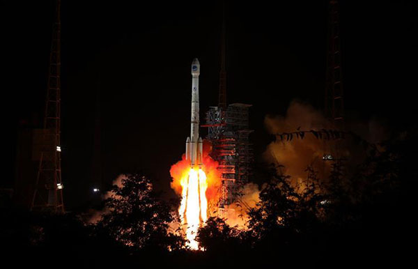
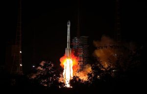
Another BeiDou launch adds to China’s constellation
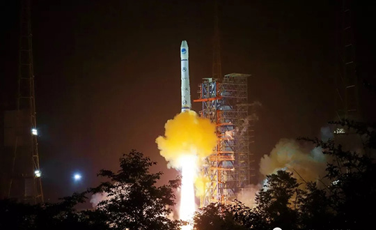
China launched two more BeiDou satellites on Aug. 25. (Photo: CCTV) China successfully sent twin BeiDou navigation satellites into space on Aug. 25, aboard a single carrier rocket, according to news reports. The satellites are numbers 35 and 36 in the BeiDou navigation constellation.
Only a few weeks ago, China launched another pair of BeiDou-3 navigation satellites.
The Long March-3B carrier rocket lifted off from Xichang Satellite Launch Center in Southwest China’s Sichuan Province at 7:52 a.m. local time.
This was China’s 23rd orbital launch this year, surpassing the national record of 22 launches set in 2016. China Aerospace Science and Technology Corporation (CASC), the main contractor for the space program, is planning on 35 launches this year.
China launched two more BeiDou satellites on Aug. 25. (Photo: CCTV via Weibo) -
China launches new twin BeiDou-3 navigation satellites
China has launched another pair of BeiDou-3 navigation satellites, reports Xinhua News Agency, China’s state-run press agency.
A Long March-3B carrier rocket lifted off from Xichang Satellite Launch Center in southwest China’s Sichuan Province on July 29.
The twin satellites are the 33rd and 34th of the BeiDou navigation system. They entered orbit more than three hours after the launch. After a series of tests, they will work together with eight BeiDou-3 satellites already in orbit, said the launch service provider.
A basic system with 18 BeiDou-3 satellites orbiting will be in place by the end of 2018, and will serve countries participating in the China-proposed Belt and Road Initiative.
Named after the Chinese term for the Big Dipper, the BeiDou system started serving China in 2000 and the Asia-Pacific region in 2012. It will the fourth global satellite navigation system after the U.S. GPS system, Russia’s GLONASS and the European Union’s Galileo.
The satellites and the rocket for Sunday’s launch were developed by the China Academy of Space Technology and China Academy of Launch Vehicle Technology, respectively. This was the 281st mission of the Long March rocket series.
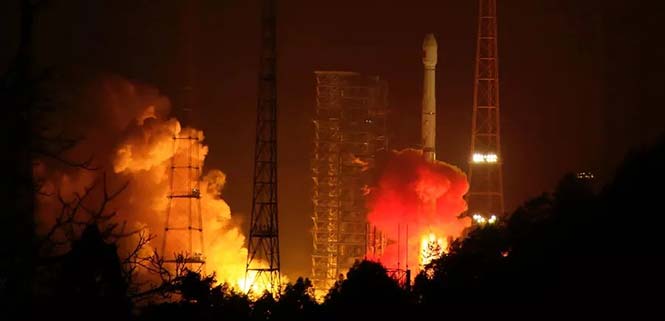
China sends the 33rd and 34th BeiDou satellites into space on July 29. (Photo: Xinhua/Liang Keyan) -
China launches backup Beidou-2 navigation satellite
China sent a Beidou-2 backup navigation satellite into orbit on a Long March-3A rocket from the Xichang Satellite Launch Center, in the southwestern Sichuan Province, at 4:58 a.m. on July 10, according to Xinhua.net.
China started to construct the third-generation of Beidou system in 2017, and eight Beidou-3 satellites are now in space. The satellite just launched is a second-generation Beidou-2, and the 32nd of the Beidou navigation system.
“The launch of a backup Beidou-2 satellite will ensure the system’s continuous and stable operation,” said Yang Hui, chief designer of the Beidou-2 series.
Some of the Beidou-2 satellites are nearing the end of their lives and need to be replaced by backup satellites. China launched two backup satellites on March 30 and June 12, 2016.
This new backup is not a simple repeat of previous satellites, but has been upgraded to improve its reliability, Yang said.
It carries redundant rubidium clocks, which is the key to the accuracy of its positioning and timing.
When China began reform and opening-up 40 years ago, its satellites mainly used costly imported rubidium clocks. After the launch of the Beidou program, the United States banned exports of rubidium clocks to China.
Sun Jiadong, chief designer of the Beidou system and an academician of Chinese Academy of Engineering, said China must depend on itself.
China’s first self-developed rubidium clock was tested on a satellite in September 2006. The performance of China’s rubidium clocks was improved on Beidou-2 satellites.
This year will see an intensive launch of Beidou satellites. The system is expected to provide navigation and positioning services to countries along the Belt and Road by late 2018. By around 2020, the Beidou system will go global.

Photo: Xinhua.net The Beidou-3 satellites can send signals that are compatible with other satellite navigation systems and provide satellite-based augmentation, as well as search and rescue services in accordance with international standards. The positioning accuracy is 2.5 to 5 meters.
The Beidou system will coordinate with other technology, such as remote sensing, the Internet, big data and cloud computing, in future.
In the past five years, the system has helped rescue more than 10,000 fishermen. More than 40,000 fishing vessels and around 4.8 million commercial vehicles in China have been equipped with Beidou, said Beidou spokesperson Ran Chengqi.
China has sold more than 50 million domestically manufactured chips connected to the Beidou navigation and positioning system in the past five years.
By 2020, the value of China’s satellite navigation business is expected to surpass 400 billion yuan (about 58 billion U.S. dollars), of which 240 billion to 320 billion yuan will go to the Beidou system, Ran said.
Photos: Xinhua.net
-
China to launch 11 more BeiDou-3 satellites this year
China will launch 11 more BeiDou-3 satellites by the end of 2018, according to the Xinhua News Agency, the official state-run press agency.
China has already launched eight BeiDou-3 satellites for its domestic BeiDou Navigation Satellite System. The satellites will provide initial services for countries and regions along the Belt and Road by the end of the year, said Wang Li, chairman of the China Satellite Navigation System Committee.
Addressing the Ninth China Satellite Navigation Conference in Harbin, capital of northeast China’s Heilongjiang Province, Wang said the BeiDou system is moving to become a global service provider after offering stable and reliable time and space information for clients in the Asia-Pacific region.
China launched the first two BeiDou-3 satellites into space via a single carrier rocket in November 2017, as its self-developed BeiDou system officially began to expand into a global network.
Compared to earlier generation satellites, the BeiDou-3 is able to send signals that are more compatible with other satellite navigation systems and provide satellite-based augmentation, as well as search-and-rescue services in accordance with international standards. Its positioning accuracy has reached 2.5 to 5 meters.
-
Auto-scanning total stations working on China’s expressways
Spectra Precision‘s Focus 35 robotic total stations are helping build the world’s largest expressway network. For instance, the Focus 35, with its time-saving automatic scan template, is checking the cross-section quality of the twin Nan Kunshan tunnels for the new six-lane Shazhan S14 regional highway.
Excavation under Nankun Mountain for the twin tunnels, each 4.1 kilometers (km) long and each capable of carrying three lanes of vehicular traffic, began in September 2016.
In the current second phase of construction, the Focus 35 is being used to gather data that will be used to compare the as-built tunnels to the design specifications to determine what adjustments to the tunnel surfaces may need to be made.
The Focus 35 was selected for the scanning work because it offers a streamlined and efficient workflow that yields significant time-savings, the company said. The workflow of a conventional total station requires time-consuming manual scanning followed by export to a separate post-processing function after which a DXF file is generated.
The Focus 35, with its Trimble Access Tunnel software, saves significant time because it automatically scans and directly generates DXF reports for submission to the contractor to check over-break and under-break values, the company said.
When completed, the new six-lane 800-km Shazhan highway will connect Shantou and Zhanjiang, two important coastal cities in southern Guangdong province. The contractor for the Nan Kunshan tunnels is ChangDa Highway Engineering Co. Ltd.
-
STMicroelectronics sensors validated for Alibaba IoT
STMicroelectronics has confirmed the validation of its LSM6DSL 6-axis inertial sensor and LPS22HB pressure sensor for the Alibaba internet of things (IoT) ecosystem, which enables users to create complete IoT nodes and gateway solutions with better time to market.
Launched in 2017, AliOS Things is a light-weight embedded IoT operating system developed by Alibaba. The company recently released AliOS Things v1.2, which includes a sensor-based component called uData.
The ST sensors that have passed the AliOS validation have been integrated in uData, and the two companies are cooperating on the development of IoT systems that aim to improve end-user experiences.
The LSM6DSL is a system-in-package featuring a 3D digital accelerometer and a 3D digital gyroscope that operates at 0.65 mA in high-performance mode and enables always-on low-power features for an optimal motion experience for the consumer.
According to the company, high robustness to mechanical shock makes the LSM6DSL the preferred choice of system designers for the creation and manufacturing of reliable products. The LSM6DSL supports main OS requirements, offering real, virtual and batch sensors with 4 Kbytes for dynamic data batching.
The LPS22HB is an ultra-compact piezo-resistive absolute pressure sensor that functions as a digital output barometer. Dust-free and water-resistant by design, the sensor enables high accuracy and low-power operation. It is available in full-mold package with silicon cap and six 20-µm holes guaranteeing sensor moisture resistance, relative accuracy of pressure measurement 0.1 mbar, and very low power consumption (12 µA in low-noise mode).
“The validation by Alibaba of ST’s LSM6DSL and LPS22HB sensors is an important achievement,” said Collins Wu, marketing director, Analog and MEMS Group, Greater China & South Asia, STMicroelectronics. “Creating and connecting nodes quickly and securely is facilitated by the holistic platform of AliOS, which cuts time to market for users and allows them to create IoT systems in China quickly for applications in smartphones, smart watches, smart locks, smart parking and beyond. On top of this, Alibaba is collaborating closely with ST to integrate more products in the platform, offering compelling IoT solutions for customers.”
-
China launches another pair of BeiDou-3 satellites
China continues to update the BeiDou navigation satellite system. On Feb. 12, two more navigation and positioning satellites were launched into medium Earth orbits, following the successful launch of a pair of BeiDou satellites on Jan. 11.
A Long March 3B rocket with a Yuanzheng-1 upper stage lifted off from the Xichang Satellite Launch Center, Sichuan Province, at 13:03 local time (05:03 UTC), according to gbtimes.com.
Stay up-to-date with our Upcoming GNSS Satellite Launches table, maintained by Richard Langley.
The launch had been set for the same window on Feb. 10, but was delayed by the visit of Chinese president Xi Jinping to the launch site.
Success of the mission was confirmed four hours after launch, following insertion of the satellites into their intended orbits, around 21,000 kilometers above the Earth.
The newly launched pair are BeiDou-3 28 and 29. The satellites are part of a third phase of Beidou deployment, which will take Beidou coverage from regional to covering the countries along the Belt and Road initiative by the end of 2018, and global by 2020.
According to Nasaspaceflight.com, the satellites are using a new bus featuring a phased array antenna for navigation signals and a laser retroreflector, with a launch mass of 1,014 kg.
The accuracy, stability and signal strength of the Beidou-3 satellites is improved over previous versions by developments in atomic clocks, laser communications and inter-satellite links.

The Long March 3B/YZ-1 carrying Beidou satellites 28 and 29 lifts off from Xichang Satellite Launch Centre at 13:03 local time on Feb. 12. (Photo: CNS) -
China launches twin BeiDou-3 navigation satellites
China launched twin BeiDou-3 navigation satellites into space on Jan. 12 as part of efforts to enable its BeiDou system to provide navigation and positioning services to countries along the Belt and Road by the end of 2018, reports XinhuaNet.
China’s Belt and Road Initiative aims to create the world’s largest platform for economic cooperation.
The pair of satellites was launched at 7:18 a.m. local time aboard a Long March-3B carrier rocket from Xichang Satellite Launch Center in southwest China’s Sichuan Province. The twin satellites are coded the 26th and 27th satellites in the BeiDou Navigation Satellite System.
This is the first launch of the BeiDou satellites in 2018, which will see intensive launches throughout the year.
The twin satellites are coded MEO-7 and MEO-8, the 26th and 27th satellites in the BeiDou Navigation Satellite System.
-
ComNav Technology tracks third-generation Beidou signals
Following the successful launch of the third-generation BeiDou satellites, ComNav Technology has been tracking and decoding the BD-3 satellite signals to provide better high-precision positioning services in the near future.
As the world’s fourth navigation satellite system, the construction of BeiDou satellite navigation network consists of three steps: experimental period from 2000 to 2003, regional coverage by 2012, and global reach by 2020.
On Nov. 5, 2017, the launch of two third-generation BeiDou satellites indicates that China has begun to upgrade its BeiDou Navigation Satellite System with global-coverage capabilities, according to the China Satellite Navigation Office.
The new-generation BeiDou satellites feature better accuracy, stability and signal clarity, thanks to improvements in laser communication devices, intersatellite links and atomic clocks.
Moreover, 18 third-generation BeiDou satellites will be launched by the end of 2018 to cover all nations involved in the Belt and Road Initiative. By the end of 2020, worldwide high-precision GNSS users are able to benefit from global reach of the third-generation Beidou system.
ComNav Technology has tracked and decoded the latest format BD-3 satellite signals: B1C and B2a from satellites Beidou-19 and Beidou-20.
The following figure shows the BD-3 No. 20 signal tracked with the SinoGNSS K708 GNSS OEM board.
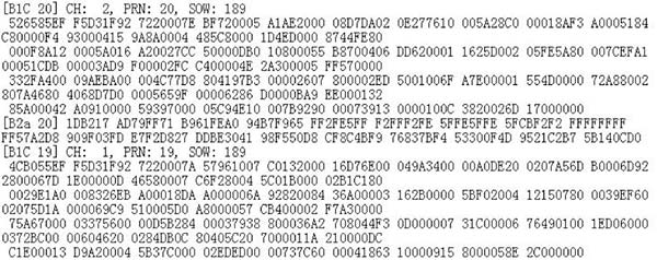
Chart: ComNav According to ComNav, with its strong R&D capability in high-precision GNSS, ComNav Technology plans to grow with the third-generation BeiDou navigation system to bring better positioning services all the time.
