Tag: construction

  • Topcon Unveils 2D, 3D Excavator Control Systems

    Topcon Unveils 2D, 3D Excavator Control Systems

    X-32_studio_Topcon-W

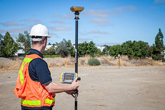
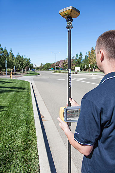
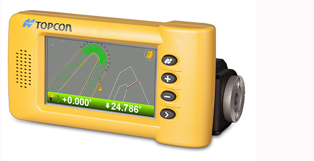
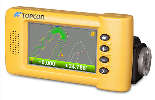
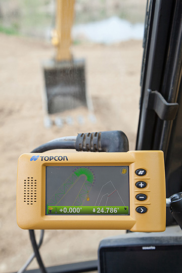
    Topcon Positioning Group announces the addition of two new indicate control systems to its excavator control system lineup — the X-32 and X-33. The systems feature Topcon’s new GX-30 control box and TS-i3 sensors.

    The GX-30 features a full-color touchscreen display. The TS-i3 sensors have no moving components, offer single and dual-axis measurement modes, and include convenient LED status indicators.

    “The X-32 is a versatile and easy-to-use 2D excavator system that includes technology not available on other, more expensive systems,” said Kris Maas, manager for machine control product marketing.

    X-32_cab_Topcon-W“The X-32 is an excavator grade indication system to fit any budget. With this new system, you have the flexibility to use a wide array of references from which to work: Existing surface, a hub, previous cut, single slopes and dual slopes with the use of a compass or rotating laser. It’s as easy as choosing your reference and entering a cut and/or slope depth,” Maas said.

    “The X-32 allows an operator to work faster, with consistency and greater degree of accuracy, and promotes a safer work site by keeping a grade checker out of the trench.”

    Additionally, Maas said, “The X-32 grows as your needs expand because it’s easily upgradeable to a 3D system.”

    “The X-33 adds Topcon’s industry-leading GNSS satellite technology to create a highly productive 3D indicate excavator grade control system,” Maas said. The system’s MC-i3 GNSS receiver with Vanguard technology provides “maximum flexibility in satellite signal tracking.  Additionally, the MC-i3 is Sitelink3D ‘ready’ for integration into Topcon’s real-time 3D management solution,” he said.

    The new 3D system is designed to establish grade faster and ensure the operator stays on grade. “The system eliminates over excavation and controls material usage, allowing the user to ‘see’ the exact position of the machine on site and the bucket position at all times,” Maas said. When detailed information is required, the operator can select to visualize the plan, profile, or sectional view and use the dual grade indicators for elevation control.

  • Topcon Acquires DynaRoad, Opens Technology Center

    Topcon Positioning Group has acquired DynaRoad Oy, a construction software company in Helsinki, Finland. In conjunction with the acquisition, Topcon also announced the establishment of the Topcon Helsinki Technology Center.

    In 2011, Topcon acquired a significant share of DynaRoad, a company that develops project management software specifically designed for large-scale construction projects — highway, tunnel, railway, area development and harbor.

    Ray O’Connor, Topcon president and CEO, said by acquiring 100 percent of DynaRoad, “Contractors and designers who are looking to cut construction costs through design optimization and better task management now have a strong central source for production management with DynaRoad being integrated to other Topcon systems. The new technology center in Helsinki has a strong foundation as the team has already worked with Topcon for approximately four years. We look forward to releasing new world-class products with them.”

    The DynaRoad software combined with Topcon’s Sitelink3D Enterprise, a real-time task management tool, creates “an integrated machine control solution for all phases of earthworks projects, from pre-planning to construction,” O’Connor said.

    Juuso Makinen, CEO of DynaRoad, said the acquisition “finalizes the close working relationship the two companies have had for years. This is a natural step to take as the integration of machine control and planning software enables us to automate many aspects of production management. Automating manual repetitive tasks such as task progress monitoring means our customers will have a better understanding of their site’s status and more time to spend on optimizing production.”

    “DynaRoad is a perfect fit to the Topcon organization,” said Ivan Di Federico, Topcon chief strategy officer. “The focus of their software and services is on construction economics — namely time and cost optimization. These products and experiences, together with Topcon’s machine automation and real-time communication, will bring our customers to the next level of productivity.”

    As a result of the acquisition, the DynaRoad products will be available through Topcon dealers worldwide.

    With the new Helsinki Technology Center, Topcon now has seven technology centers around the globe, including in Japan, Australia, Italy and Russia, plus two in the United States (Ohio and California).

  • Navman Wireless Expands Construction/Mining Fleet Tracking Coverage with Satellite Communications Option

    Navman Wireless Expands Construction/Mining Fleet Tracking Coverage with Satellite Communications Option

    Photo: Navman Wireless USANavman Wireless USA today announced a new satellite communications option for its OnlineAVL2 fleet tracking platform, enabling continuous visibility of both heavy equipment and on-road vehicles even when assets are out of cellular coverage. Designed for construction, surface mining, mining and oil and gas exploration, and other environments with remote location work, the new solution includes the ability to minimize data charges by transmitting only the most critical event information via satellite.

    Satellite connectivity is provided via a small modem that plugs into the serial port on Navman Wireless’ Qube on-highway or ruggedized Qtanium off-highway GPS tracking devices. The system automatically switches between cellular and satellite transmission with intelligent least-cost routing, using the global Iridium satellite network when fleet assets move out of cellular range. Benefits include:

    • Uninterrupted real-time fleet tracking without losing visibility of equipment location and other status information when assets are beyond the reach of cell towers.
    • Increased employee safety because equipment and vehicles are never out of sight of the fleet tracking system, even if they are working in cellular dead zones.
    • No missed engine alerts, potentially preventing costly machine repairs and downtime by ensuring that job supervisors are promptly informed when engine, coolant, transmission or air filter sensors connected to GPS tracking devices exceed pre-defined thresholds.
    • Cost-saving configurability, with the option to limit satellite transmissions to priority events (panic messages, rollover alerts, engine overheating, speed or geofence violations, etc.) and delay the transfer of low-priority event data until cellular coverage is restored.

    “If a machine or vehicle in your fleet is operating outside of cell coverage and you have critical communications that need to take place for safety or operations reasons, it can be a problem to wait until the asset gets back into cell range,” said Davis Gammage, VP Product Management, Navman Wireless. “Temporarily switching to satellite communication solves the problem and ensures 100% visibility of your equipment as well as your field staff.”

    The new satellite communications option marks the latest expansion of Navman Wireless’ fleet tracking portfolio for the construction, mining, and oil and gas industries. The company’s OnlineAVL2 fleet tracking platform provides location, operations and performance data for both on-highway vehicles and construction heavy equipment from a single interface. The back-end OnlineAVL2 application — delivered under the software-as-a-service model — includes industry-specific reporting such as jobsite utilization reports that break down equipment use by project, facilitate proper cost accounting, reduce writeoffs for unallocated asset hours, and aid in the development of future job bids for construction customers.

  • Topcon Announces GR-5 with Vanguard Technology

    Topcon Announces GR-5 with Vanguard Technology

    Topcon GR-5 with Vanguard technology.
    Topcon GR-5 with Vanguard technology.

    Topcon Positioning Group has released the GR-5 receiver with Vanguard technology, designed to optimize tracking and performance.

    “The GR-5 is a next-generation GNSS receiver, built on multi-constellation integrated technology pioneered by Topcon,” said Scott Langbein, director of product marketing.

    “Now with the inclusion of Topcon’s exclusive 226-channel Vanguard technology with Universal Tracking, and the power of full-wave Fence Antenna technology that provides multipath rejection in difficult environment, the GR-5 operates with unsurpassed sensitivity, tracking accuracy and performance.”

    In addition to Universal Tracking, Vanguard technology includes Quartz Lock Loop for signal processing in heavy vibration applications and Intelligent Tracking Optimization to select the best combination of available satellite signals.

    “At any time, end-users can track all available satellite signals and be assured of getting accurate measurements regardless of environmental conditions,” Langbein said.

    Additional features of the GR-5 include:

    • Cellular and radio: The GR-5 has both cellular and radio communications, which allows it to be used in radio-based RTK and network RTK systems;
    • Long-range UHF radio: The top-mounted radio antenna extends the range of RTK radio performance;
    • Operating time: GR-5 hot-swappable batteries are designed for full-day operation;
    • MAGNET Field: MAGNET Field software can be used with the GR-5 RTK system, providing the ability to share data to cloud storage and connect field crews to each other and the office.
  • Spectra Precision Shows off New and Updated Products for Surveying

    Spectra Precision Shows off New and Updated Products for Surveying

    Photo: Spectra Precision
    Photo: Spectra Precision

    Spectra Precision introduced at Intergeo this week new and updated products to expand its portfolio of solutions addressing the needs of the mainstream surveying and construction markets. Intergeo 2013 is a geodesy, geoinformatics and land management trade event being held in Essen, Germany.

    “Earlier this year, we introduced a new reflectorless entry-level total station, the lightweight ProMark 700 RTK Network Rover and the Layout Pro construction layout software suite. With our latest additions, the Spectra Precision portfolio continues to evolve to meet the changing needs of our users,” said François Erceau, general manager of Spectra Precision’s GeoInstruments Business Unit. “Spectra Precision now offers one of the broadest and most complete portfolios of survey and construction products in the industry — from construction lasers and total stations to survey GNSS receivers and GIS handhelds — all from a single supplier that customers can trust.”

    New and updated Spectra Precision products include:

    • Spectra Precision EPOCH 50 firmware 4.81 – now supports RTK positioning using the Chinese BeiDou open service GNSS satellite signals. Adding the BeiDou constellation to the full range of GPS and GLONASS signals already tracked by EPOCH 50 further boosts the capabilities of this GNSS receiver to enable faster initialization and performance, even in conditions where satellite visibility is obstructed due to tree canopy or tall buildings.
    • MobileMapper 120 Decimeter Edition this new kit, based on the MobileMapper 120 handheld GNSS receiver, includes the Flying RTK, GLONASS tracking and NTRIP correction options. With accuracy of 20cm or better, the Decimeter Edition kit is a competitively priced solution for precise Mobile Mapping applications.
      • ProFlex 800 firmware version 1.9 – now supports GLONASS-only mode and tracking of QZSS signals to meet the needs of specific markets (Russia and Japan, respectively). This updated firmware also improves RTK performance in VRS networks, particularly in challenging GNSS environments, through Z-Blade technology enhancements.
    • Layout Pro Field and Office software – a recent release of the Layout Pro field software added support for the FOCUS 30 Robotic Total Station, offering the highest level of productivity and accuracy in a construction layout solution. The Layout Pro version 2.1.1 update now includes language packs for major markets worldwide, in addition to many other minor enhancements. Customers with a current Layout Pro maintenance agreement are eligible to download this update from www.spectraprecision.com.
    • Survey Basic software for total stations – further enhancements to this entry-level software application make for the simplest starting point, with workflows that mirror the familiar Nikon-style FOCUS 6 user interface in a modern full-color touch-screen instrument (FOCUS 8). Further language packs have been added, including Czech, Traditional Chinese, Korean and Polish.
    • Survey Pro Field software version 5.4 –  the latest release of this award-winning survey field software includes many new features and enhancements such as:
      • Updated Digital Terrain Model (DTM) features and interface
      • Support for new GNSS constellations and an improved GNSS workflow
      • Additional Active Map enhancements that make it easier than ever to work directly from the map screen
      • Updated point staking routines and a new interface for building design point lists
      • A new Plane and Vertical Angle Offset routine
      • A new electronic compass display in various map screens
      • Enhanced total station and GNSS setup routines
      • An improved Code/Description entry and display system

    Customers with a current Survey Pro maintenance agreement are eligible for this update and can download the software from .

    • Spectra Precision Survey Office software v3.10 and v2.95 ­– both versions are companions to Survey Pro 5.4 field software and FAST Survey field software, and offer enhanced baseline processing with more reliable outlier detection and improved accuracy statistics. Additionally, version 3.10 features a new customized ribbon UI and is optimized for 64-bit PCs (with notably faster processing).

    These new and updated Spectra Precision products are now available for order through the Spectra Precision global reseller network.

  • Trimble Offers New Version of Deformation Monitoring Software


    Trimble introduced today the latest version of its deformation monitoring software, Trimble 4D Control version 4.2. The new version of the monitoring software delivers enhanced communications with the Trimble NetR9 and new NetR9 Ti-M GNSS receiver, REF TEK seismic sensors and the Trimble S8 total station. It also supports geotechnical sensors, weather stations, level data and it provides velocity and trend computations as well as a calculation facility for mathematical operations. The interactive Web interface provides advanced alarms, data visualization and analysis tools. Site access is controlled by user login credentials.

    The announcement was made today at Intergeo 2013, being held in Essen, Germany, October 8-10.

    Trimble NetR9 Ti-M. Trimble also introduced a dedicated GNSS monitoring receiver, the Trimble NetR9 Ti-M, designed for real-time monitoring applications. This instrument is the fourth-generation of the proven Trimble NetR9 series of GNSS reference receivers, and is specifically designed for the monitoring market and supported by Trimble 4D Control software.

    Trimble REF TEK Sensors. Following the acquisition of REF TEK, now a division of Trimble and a provider of seismic sensors and data recording instruments, support for REF TEK accelerometers has been included in Trimble 4D Control version 4.2. Different variants of peak acceleration that are used in monitoring the effects of vibration on structures such as micro-seismic activity, proximity blasting or impact piling can be visualized and alarmed in Trimble 4D Control.

    Trimble 4D Control is a fully scalable and comprehensive software solution for both real-time and post-processed monitoring projects. The software solution is ideal for the long-term, automated monitoring of dams, bridges, buildings, support piers, large-scale construction and excavation sites, open pit mines, landslides, tunnels and other structures. Real-time management and control of the monitoring system is available via the Trimble 4D Control Web Interface on-site, online and around the clock from any location with Internet or Intranet connectivity.

    “To date, this advanced technology has only been available to end users of an automated monitoring system.  We recognized the need to provide this functionality across the full spectrum of monitoring applications,” said Ulrich Vollath, general manager of Trimble’s Infrastructure Division. “We are pleased to announce the launch of Trimble 4D Lite, a cloud-based subscription service which will make this solution available to small- and medium-sized monitoring projects. With the introduction of 4D Lite, Trimble’s monitoring solutions are now available for the full spectrum of monitoring projects, from small, non-permanent, campaign monitoring projects through to permanent, fully automated monitoring systems.”

    Trimble 4D Lite – Advanced Cloud Monitoring Service. 4D Lite is a cloud-based application that is designed with an interface familiar to existing Trimble monitoring technology users. 4D Lite is designed for surveyors, engineers and scientists to perform campaign monitoring of data/time series without the need to integrate directly with onsite hardware and sensors. Trimble 4D Lite can be used to meet campaign monitoring needs of installations on dams, bridges, mines, landslides, buildings and other natural and man-made hazards or structures using sensors to monitor health. Data can be integrated from a wide range of sensors. The data can be visualized and analyzed on a variety of interactive charts and scatter plots and the sensors can be viewed in context with the structure using a variety of backdrops including maps, plans or photographs.

    Trimble 4D Control version 4.2, the NetR9 Ti-M GNSS receiver and the 4D Lite monitoring service are available now from Trimble’s worldwide Infrastructure distribution network.

  • Topcon’s Hybrid Positioning Combines GNSS, Optical Measurement

    Topcon’s Hybrid Positioning Combines GNSS, Optical Measurement

    Photo: Topcon Positioning Group
    Photo: Topcon Positioning Group

    Topcon Positioning Group announces a new technology — Hybrid Positioning — that increases efficiencies and improves productivity on job sites, regardless of conditions, terrain or location. Hybrid Positioning is enabled through the Topcon Magnet software suite, a Topcon enterprise solution for the geomatics industry.

    The new Topcon technology allows precise positioning professionals in the survey, construction, civil engineering and GIS industries to simultaneously connect to GNSS signals and standard robotic measurements on a single rover pole.

    “This extremely clever and unique combination of GNSS and optical measurement is aimed squarely at improving a company’s profitability by allowing the use of GNSS positioning and optical positioning data at the same time,” said Ewout Korpershoek, chief marketing officer of Topcon Positioning Group. “When used with Topcon Magnet software, Hybrid Positioning improves field measurement efficiency at every phase of a project. With Hybrid Positioning technology, the key is versatility. For example, when line-of-sight is blocked, shots can be easily and quickly measured with the GNSS receiver. Now it is so easy to combine a standard Topcon robot and GNSS receiver to guarantee an integrated solution for the highest performance and productivity.

    Photo: Topcon Positioning Group
    Photo: Topcon Positioning Group

    “Combine these two proven solutions, plus advanced Magnet Field software, and you have Hybrid Positioning technology,” Korpershoek said. “By utilizing both GNSS and optical measurement, any project can be completed faster and with unsurpassed accuracy. By adding Magnet cloud-connected data workflow, truly outstanding increases in productivity and cost savings are assured.”

    The new technological breakthrough has four key components: Hybrid Lock, Hybrid Resection, Hybrid Switch and Auto-localization.

    Hybrid Lock allows accurate prism tracking by simply turning the instrument toward the prism location. Hybrid Resection ensures quick job site setup, as well as establishing RTK and geodetic coordinates. Hybrid Switch ensures a quick changeover from GNSS to optical measurement with a single touch. Auto-localization utilizes Bing Maps background, multi-point localization and works with RTK and NMEA positioning.

    “Regardless of job site location or adverse conditions or terrain, Hybrid Positioning systems will perform faster in the field than other instruments and with more versatility than an RTK-only system,” Korpershoek said.

  • EarthCam Premieres Construction Time-Lapse Movie to Commemorate Opening of the Bay Bridge

    Watch EarthCam’s time-lapse movie of the construction progress for one of the largest ARRA (American Recovery and Restoration Act) funded projects in our nation’s history.

    More than 42,000 hours of construction can be seen in just four minutes with the release of EarthCam’s official time-lapse movie for the San Francisco-Oakland Bay Bridge. After many years of construction to retrofit and transform the Bay Bridge, project teams and contractors will be celebrating all of their hard work at the opening of the updated bridge today, September 3.

    The Metropolitan Transportation Commission (MTC) relied on 12 EarthCam construction cameras to document progress for the $6.4 billion bridge. In 2008, EarthCam installed a combination of live streaming video cameras and high definition time-lapse systems, all carefully documenting progress from several unique perspectives. Strategically located on the project site, each camera captured a specific view of the progress, archiving footage from 42 preset angles. During the life of the project, views of progress, as well as important information about construction-related lane closures, were made available on the Webby award-winning public web page.

    EarthCam’s construction cameras captured nearly six years of progress, a powerful testament to the hard-working and dedicated bridge teams. The EarthCam Time-Lapse Production Team pored over the staggering number of images captured over the past 59 months and spent months hand-editing the archived imagery into a professional time-lapse movie.

  • Handheld Ships New Version of Algiz 7 Tablet

    Handheld Group has announced the launch of the new version of its popular Algiz 7 rugged tablet computer. The updated Algiz 7 is considerably faster than its predecessor, with better storage capacity, improved security and quicker communication capabilities.

    According to the announcement, the ultra-rugged Algiz 7 tablet PC is small, light and fast, with multiple connectivity options and a wide range of functions, ideal for field workers demanding a super-durable product that is tough and powerful, yet light and easy to work with. The Algiz 7 meets stringent MIL-STD-810G military standards for withstanding humidity, vibrations, drops and extreme temperatures, and with its IP65 rating it keeps dust and water out as well.

    Algiz-7-handheld-tablet-facing-left-newThe new Algiz 7, which started shipping this week, features the following improvements from earlier versions:

    • A fast and powerful N2600 1.6 GHz Dual-Core Intel ATOM processor.
    • More memory, with 4 GB of DDR3 RAM.
    • Better storage, with a 128GB SSD SATA II with recovery partition.
    • Two full mPCIe slots for improved flexibility.
    • Ethernet 10/100/1000 (Gigabit).
    • Added data security with TPM chipset board (chip 1.2).
    • An updated version of the wireless Gobi 3000 technology for higher communications speed.
    • A 5-megapixel camera.
    • Antenna diversity (two antennas) for improved coverage.

    “We’ve made significant improvements to the new Algiz 7,” said Jerker Hellström, CEO of Handheld Group. “Better storage, a much faster processor, improved security, a better camera and better communications are some enhancements – and we’ve kept the price point the same as for the previous version of the Algiz 7. This product should remain the tablet of choice for anyone looking for portable, professional field performance.”

    The Algiz 7 weighs 1.1 kilograms and has a 7-inch widescreen touch display that features the new and unique MaxView technology, providing brightness in outdoor conditions — even direct sunlight. It runs the state-of-the-art Microsoft Windows 7 Ultimate operating system. GPS navigation functionality is fully built in.

    The Algiz 7 is specifically developed for use in tough environments in industries such as mining, geomatics, logistics, forestry, public transportation, construction, utilities, maintenance, military and security.

  • Trimble Offers Site Positioning System for Small Construction Companies

    Trimble introduced today a Site Positioning System designed for owner operators, small site contractors or construction companies new to GPS. The Trimble Site Positioning System Essentials Kit is comprised of the new Trimble Site Mobile controller, Trimble SCS900 Site Controller Software and Trimble SPS985L GNSS Smart Antenna for a complete GPS positioning solution. Using GPS, a grade checker or site engineer can check a grade, slope or alignment more accurately and in less time than with traditional construction survey methods.

    “The Trimble Essentials Kit is an exciting new addition to our positioning portfolio,” said Elwyn McLachlan, business area director for Trimble Site Positioning Systems. “Budget-conscious contractors can realize a quick return on investment by giving more personnel on the job site access to technology, enabling more productive and efficient field crews.”

    The slim, lightweight and rugged Trimble Site Mobile controller is an all-in-one mobile device that enables enhanced connectivity in the field. Featuring a large, capacitive touch screen with superior sunlight readability, an integrated 8-megapixel camera and the convenience of a built-in smartphone, the Site Mobile eliminates the need to carry multiple devices on the construction site.

    A new, entry-level version of Trimble SCS900 Site Controller Software has been designed to run on the Site Mobile controller. The software is simple to use and learn, making it ideal for contractors who are new to construction technology. In addition, the SCS900 is upgradeable to more complex functionality as a contractor’s needs change.

    The SPS985L GNSS Smart Antenna has the same tough casing and compact design as other Trimble GNSS Smart Antennas at an attractive price point. For accurate construction site measurement, the SPS985L provides precision Real Time Kinetic (RTK) positioning by using GPS and GLONASS.

    The Essentials Kit can be upgraded to take advantage of Connected Site technology, including VRS networks, Internet Base Station Service (IBSS), Trimble Remote Assistant and wireless data sync.

  • CHC Offers LT400HS GNSS Handheld

    CHC Offers LT400HS GNSS Handheld

    CHC
    The LT400HS GNSS by CHC.

    CHC today announced the availability of the LT400HS, a rugged 120-channel GPS+GLONASS handheld receiver designed to achieve sub-meter SBAS positioning to centimeter accuracy in RTK networks. The LT400HS is designed to be a cost-effective yet powerful GNSS device for survey, construction and GIS professionals.

    The LT400HS is designed for companies that have not yet invested in GNSS technology due to cost or occasional equipment use, such as earth-moving and landscape contractors, real estate developers, construction SMEs, agriculture irrigation companies, and utilities mapping companies.

    “The LT400HS GNSS handheld series is a compact, rugged, accurate and easy-to-use GNSS receiver to perform surveying and precision mapping tasks wherever RTK Network corrections are available,” said George Zhao, CEO of CHC. “The LT400HS offers unrivaled performance, an attractive price point filling the price performance gap that exists in the industry between GIS level collectors and professional RTK rovers such as our recently introduced X+ GNSS Series. ”

    The LT400HS Series features:

    • Professional 120-channel GNSS Engine – L1/L2 GPS + GLONASS supporting RTCM network RTK corrections and industry standard NMEA output.
    • 3.7” daylight readable transflective VGA touch screen.
    • Built-in GSM/GPRS phone with data transmission, Bluetooth and Wi-Fi connectivity.
    • Built-in 5 megapixel autofocus camera to capture assets information.

    It comes bundled with Carlson’s SurvCE software for survey and construction professionals, or DigiTerra Explorer Mobile GIS software  for accurate GIS field data collection and maintenance.

  • Flowfinity Introduces Mobile Survey Software for Businesses

    Flowfinity Wireless, Inc., a provider of enterprise mobile applications, has announced a solution that enables businesses to quickly create and deploy mobile surveys for offline data collection and submission to a centralized database. Flowfinity’s survey customization and integration features help businesses improve productivity through better management of information collected in the field, the company said.

    Survey data can be captured anywhere, even in locations without network coverage such as job sites, retail store stock rooms, or manufacturing plants. Feedback submitted in real time to a Flowfinity database provides actionable insights that allow businesses to improve efficiency and identify issues that require immediate attention, the company said. Information stored in the database such as survey results, locations, or customer data can also be easily retrieved on mobile devices.

    Flowfinity mobile surveys configured using a point-and-click web-based editor can include dynamic fields such as checklists, drop-down menus, photos, signature capture, and GPS locations. Conditional field visibility allows users to be guided through the survey form based on previous answers. As soon as surveys are created, they can be immediately published to different user groups based on user permissions.

    “Flowfinity helps businesses collect and access the information they need in the field, so that they can eliminate inefficient paper and spreadsheet processes,” says Larry Wilson, VP of Sales and Marketing, Flowfinity. “While many mobile survey solutions offer simple one-way data submission, Flowfinity provides two-way access to survey data from a centralized database, allowing feedback to be viewed or submitted anytime, anywhere.”

    Flowfinity mobile survey software is available as a fully cloud-hosted or on-premise deployed solution.