GPS World is conducting a short survey to shed light on the impact of COVID-19 on the GNSS/PNT industry.
The short survey covers topics such as
changes in daily work habits
communication methods with staff, technology partners and clients
how each core sector is responding to the coronavirus pandemic
how we are all trying to remain productive despite social-distancing directives.
GPS World is committed to providing the most up-to-date coronavirus resources for the GNSS/PNT industry. We value your thoughts and opinions and would love to include your thoughts on the subject through our survey.
Results of the survey will be shared in the June issue of GPS World magazine.
With impacts related to the coronavirus developing on a daily basis, GPS World may reach out again in the near future to hear how you’re doing. As always, thank you for your continued support.
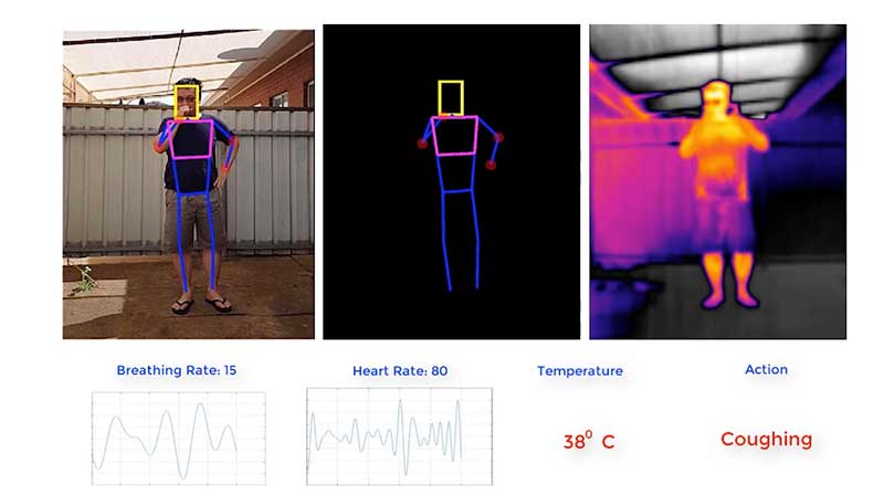
Draganfly conducted its first series of U.S. pandemic drone test flights in Westport, Connecticut.
Draganfly’s pandemic drone technology is being tested by the Westport Police Department as a new “Flatten the Curve Pilot Program.” According to Draganfly, this initiative is a collaboration of technologies developed by Draganfly, Vital Intelligence, a healthcare data services and deep learning company, and the University of South Australia.
Westport is located in Fairfield County, which has more than 17,550 confirmed cases of COVID-19. Fairfield County is adjacent to New York City, which has the most confirmed cases of coronavirus in the United States.
Image: Draganfly
Westport is deploying the technology and data tools to enhance town services, advance public safety, promote the efficient use of taxpayer dollars, engage residents and encourage growth in the local economy.
The pandemic drone will be equipped with a specialized sensor and computer vision systems that can display fever/temperature, heart and respiratory rates, as well as detect people sneezing and coughing in crowds, and wherever groups of people may work or congregate. The technology can accurately detect infectious conditions from a distance of 190 feet, as well as measure social distancing for proactive public safety practices, Draganfly said.
Westport specifically plans to use the drone technology to help protect potential at-risk groups, crowds gathering at the town and state-owned beaches, train stations, parks and recreation areas, shopping centers and other areas where people tend to gather.
“One of the major problems for cities and towns like Westport in managing and responding to a pandemic like the COVID-19 virus, is finding out who could be infected and how widespread the disease has spread,” said Jim Marpe, Westport first selectman. “One way to do this is to look for underlying symptoms. By teaming up with Draganfly and the UniSA team, led by Defence Chair of Sensor Systems Professor Javaan Chahl, we are able to remotely look at valuable lifesaving data and better manage current and future health emergencies.”
Draganfly‘s pandemic drone software uses biometric readings in its analysis process. The software can be used to understand patterns within a population to allow users to react quicker to ongoing events or new potential health threats, Draganfly added.
Draganfly manufactures UAVs and UAS, serving the public safety, agriculture, industrial inspections and mapping and surveying markets.
Traxens has introduced new pricing for its smart containers tracking system to help global partners manage the challenges presented by the COVID-19 pandemic.
“The COVID-19 pandemic is affecting supply chains across the globe. In a volatile market, supply chains must be resilient and able to adjust quickly and efficiently. Changes to global trade agreements and other factors always create some degree of uncertainty in supply chains,” Traxens stated in a press release. “This year however, COVID-19 has taken supply chain uncertainty to a whole new level.”
Traxens’ smart-container solutions provide real-time visibility into global shipments. Its smart containers and data services give customers key data insights about when, where and why disruptions or delays occur. With accurate insights provided, customers can make quick decisions and collaborate with partners and customers to minimize costs, delays and backlogs.
“If everyone across the supply chain has access to these vital insights, the industry will be better placed to return to normal once the pandemic has been brought under control.”
Small businesses, including many surveyors, are being hit particularly hard by the current economic situation caused by the measures required to fight the COVID-19 pandemic because most of them do not have large cash reserves.
The CARES Act, signed into law on March 27, contains $349 billion to keep small businesses afloat. The funds are administered by the Small Business Administration (SBA) through participating banks.
Hundreds of thousands of borrowers have been approved for, or received, aid under the so-called Paycheck Protection Program, meant to give small businesses loans that would be forgiven if they were used to pay employees, rent, or mortgage principal. The program is one of four that the SBA is administering as part of the CARES Act.
The other three are the Economic Injury Disaster Loan (EIDL) loan advance, which will provide up to $10,000 of economic relief to businesses that are currently experiencing temporary difficulties; the SBA Express Bridge Loans, which enables small businesses who currently have a business relationship with an SBA Express Lender to access up to $25,000 quickly; and the SBA Debt Relief, which provides a financial reprieve to small businesses during the pandemic.
These programs — an unprecedented challenge for the SBA, which is already struggling with a surge in coronavirus-related loan applications through other programs such as its disaster loan program — were marred by technical and logistical glitches from the start.
On April 16, while many small-business owners were desperately trying to apply for loans, the SBA ran out of the relief money. Its website’s COVID-19 page announced: “SBA is unable to accept new applications at this time for the Paycheck Protection Program or the Economic Injury Disaster Loan (EIDL)-COVID-19 related assistance program (including EIDL Advances) based on available appropriations funding. EIDL applicants who have already submitted their applications will continue to be processed on a first-come, first-served basis.”
As of press time, Congress and the White House are negotiating the possible release of additional rescue funds.
Around the world, countries are cautiously beginning to reopen businesses and activities they had shut down to limit the spread of the coronavirus.
Countries
Austria will reopen some smaller shops, hardware and garden stores but people will have to wear masks to supermarkets and on public transport. From May 1, all stores, shopping centers and hairdressers will open; restaurants and hotels will open from mid-May at the earliest.
China has largely removed restrictions on mobility while tightening policy to contain the virus transmission of asymptomatic cases.
The Czech Republic on April 6 allowed shops such as hardware and bicycle stores to re-open. Outdoor sports facilities have also reopened. Starting on April 20, students will begin a phased return to colleges and schools, but high schools are not expected to fully open until September 1. From June 8, all retail stores, including those in shopping centers, all restaurants, hotels and other accommodation will be allowed to reopen.
Denmark will reopen daycares, kindergartens and schools (up to 5th grade) on April 22, while other bans, such as on gatherings of more than 10 people, will remain in place until May 10. Churches, cinemas and shopping centers will remain closed. All festivals and large gatherings are banned until August.
Germany will allow stores with a sales area of less than 800m2 to reopen on April 20 if they maintain hygiene and prevent lines from forming. Schools with hygiene plans in place will gradually reopen from May 4, with priority given to primary and secondary pupils in final years, while daycare centers will remain shut. Other social distancing measures, along with bans on large public events, will remain in place.
India has extended what is currently the world’s biggest lockdown through May 3.
Italy allowed bookstores, laundries, stationery stores and children’s clothing stores to reopen on April 14. “Phase 2” of the three-phase reopening plan will start sometime after May 3. Businesses that reopen will be required to make hand sanitizer available, enforce the use of masks in enclosed spaces, and use disposable gloves to handle food and drink.
Japan has tightened its approach, declaring a state of emergency in Tokyo, Yokohama and Osaka, the country’s three biggest cities.
Norway is prioritizing reopening schools and will begin to scale back its lockdown measures from April 20, when kindergartens will start to reopen. A week later, schools will reopen for pupils in grades one to four.
Spain allowed many non-essential employees to return to work after the Easter weekend. Construction and other industries have been allowed to restart, but non-essential stores, bars, and restaurants remain closed. Spanish police are distributing more than 10 million masks to commuters at metro, bus, and train stations.
Switzerland has extended social distancing restrictions to April 26, but might relax other measures later this month, including border controls, school closures and bans on gatherings, if the virus’ spread is kept in check.
United States reopenings vary by state
If you cannot resist the urge to eat at a restaurant or have a drink at a bar during this pandemic without leaving the United States, head for South Dakota, the only state that has not banned these activities except for take-out.
However, unless you live in neighboring Iowa, Nebraska, or North Dakota, you will be most likely breaking the law of one of the 39 states that have banned travel that is not deemed essential or to get to work (five of them with exceptions or limitations). South Dakota and Arkansas have no travel bans and the remaining six states have a variety of advisories and bans targeted at various classes of people, such as those over 70 years old.
As for gatherings, 27 states restrict them to ten people or fewer, four states to nine people or fewer, and five states allow no gatherings at all. Only two states, North Dakota and Minnesota, have not banned any gatherings.
Twenty-five states have limited all nonessential businesses to minimum operations or remote work, three have closed all nonessential businesses, and only two states — again, Nebraska and South Dakota — have not restricted any business activity.
Finally, while 27 states have no state-wide quarantines, the remaining 23 have a bewildering array of quarantine rules for travelers depending on where they have been. However, the duration of the quarantine is always 14 days.
AIxSPACE, originally scheduled for June 1, has been rescheduled to take place Nov. 2. The conference, formed by Euroconsult and Innovitech, will bring together stakeholders in space and artificial intelligence industries to allow everyone to obtain concrete information on these markets and connect with potential business partners. It will still be taking place in Montreal, Québec, Canada.
The European Navigation Conference has been rescheduled for Nov. 22-25. According to show organizers, the conference will bring together scientists, engineers and international experts to discuss new ideas, latest research results, future developments and new applications. The European Navigation Conference event will still be taking place in Dresden, Germany.
Finally, the Connected & Autonomous Vehicles Conference will now be taking place Aug. 10-13 at the San Jose Convention Center in San Jose, California. This conference will explore the latest industry developments. In addition, attendees will hear thought-provoking case study presentations from top automakers.
The National States Geographic Information Council (NSGIC) has released a joint statement on the value of GIS during the COVID-19 pandemic, alongside its partners the MidAmerica GIS Consortium (MAGIC), Open Geospatial Consortium (OGC), Urban and Regional Information Systems Association (URISA), and American Association of Geographers (AAG).
Joint Statement on the Value of GIS in the Pandemic
The spread and effects of COVID-19 can be best understood considering space and time.
As governments are responding to COVID-19, more leaders are recognizing the value of “knowing the where.” The importance of knowing where the outbreak is growing, where high risk populations are, where the hospital beds and important medical resources are, and where to deploy resources is essential. “Knowing the where” informs better decision-making.
In an effort to better understand the where, governments are recognizing the value of geospatial information and technologies and are engaging geospatial professionals to help them better understand the where to help them in their decision-making and response.
Geospatial professionals bring unique analytical and visualization skills to the table that help responders and decision-makers visualize where the pandemic is spreading more quickly and can make the important decisions regarding where response and resource needs need to be focused. The value of telling the story through a map coupled with a geospatial dashboard provides a view of the event not readily seen in a table such as a spreadsheet.
Beyond visualizing existing data, we can connect data from a location perspective, which enhances the value of the data sources being integrated. Equally important in this event is data on COVID-19 cases and testing packaged and shared in a way useful to scientists.
GIS (geographic information systems) is experiencing an unprecedented level of use. Historically, GIS was deployed following a disaster to help respond and recover. Today, GIS is used as a disaster is unfolding. The COVID-19 event is an outstanding example of how effective GIS is when robust data is available. Governments are realizing the value of investing in these systems and the people who run them.
The information necessary to empower all partners already exists.
Current nationwide models and response efforts may not benefit from the details of local geographic parameters. Local or statewide models and response efforts may not fully take advantage of the data from other areas of the country. Hospitals are surveyed by both federal and state agencies, and the results of those surveys are not readily available to the hospitals working together to care for patients. Nationwide geospatial data will empower a coalition of participants with a better understanding of the spread and impacts of COVID-19 and improve mitigation actions.
The same data can be made available in different forms to empower people playing different roles in the response. Researchers — epidemiologists — will benefit from nationwide COVID-19 testing data and data describing factors impacting the spread. This data needs to be as disaggregated as permissible under HIPAA and in a form readily digestible in models.
The case data could be aggregated to the same units of geography as a wealth of existing demographic data (Census tracts), which could explain and quantify local variances in the spread. Policy makers and those in emergency management can benefit from map and tabular dashboards, harnessing the power of the where by integrating data for analytics.
The emergency response, public health and geospatial communities must come together to understand COVID-19 in the U.S. and mitigate its spread and overall impact.
By geo-enabling public health and emergency response data, we can better:
understand the spread — with COVID case data, movements of people, and symptoms
understand the impact on individuals — with data including age, disease, obesity, and medical treatments
understand how to tailor outreach — by age, language, engagement with government, and lifestyle choices
understand the needs of the healthcare industry — by facility, day, bed capacity, type of care, ventilators, and PPE
understand the impact on the local economy — by county, day, unemployment, and bankruptcies
understand the societal impacts — by census tract, domestic violence, alcohol consumption, child abuse, animal abuse, elder abuse, mental health crises, 3-1-1 calls and firearm sales
We are committed to beginning the national conversation about leveraging the best available data to better understand the spread and impacts of COVID-19.
The National States Geographic Information Council (NSGIC) has released a joint statement on the value of GIS in the pandemic, alongside its partners the MidAmerica GIS Consortium (MAGIC), Open Geospatial Consortium (OGC), Urban and Regional Information Systems Association (URISA), and American Association of Geographers (AAG).
Joint Statement on the Value of GIS in the Pandemic
The spread and effects of COVID-19 can be best understood considering space and time.
As governments are responding to COVID-19, more leaders are recognizing the value of “knowing the where.” The importance of knowing where the outbreak is growing, where high risk populations are, where the hospital beds and important medical resources are, and where to deploy resources is essential. “Knowing the where” informs better decision-making.
In an effort to better understand the where, governments are recognizing the value of geospatial information and technologies and are engaging geospatial professionals to help them better understand the where to help them in their decision-making and response.
Geospatial professionals bring unique analytical and visualization skills to the table that help responders and decision-makers visualize where the pandemic is spreading more quickly and can make the important decisions regarding where response and resource needs need to be focused. The value of telling the story through a map coupled with a geospatial dashboard provides a view of the event not readily seen in a table such as a spreadsheet.
Beyond visualizing existing data, we can connect data from a location perspective, which enhances the value of the data sources being integrated. Equally important in this event is data on COVID-19 cases and testing packaged and shared in a way useful to scientists.
GIS (geographic information systems) is experiencing an unprecedented level of use. Historically, GIS was deployed following a disaster to help respond and recover. Today, GIS is used as a disaster is unfolding. The COVID-19 event is an outstanding example of how effective GIS is when robust data is available. Governments are realizing the value of investing in these systems and the people who run them.
The information necessary to empower all partners already exists.
Current nationwide models and response efforts may not benefit from the details of local geographic parameters. Local or statewide models and response efforts may not fully take advantage of the data from other areas of the country. Hospitals are surveyed by both federal and state agencies, and the results of those surveys are not readily available to the hospitals working together to care for patients. Nationwide geospatial data will empower a coalition of participants with a better understanding of the spread and impacts of COVID-19 and improve mitigation actions.
The same data can be made available in different forms to empower people playing different roles in the response. Researchers — epidemiologists — will benefit from nationwide COVID-19 testing data and data describing factors impacting the spread. This data needs to be as disaggregated as permissible under HIPAA and in a form readily digestible in models.
The case data could be aggregated to the same units of geography as a wealth of existing demographic data (Census tracts), which could explain and quantify local variances in the spread. Policy makers and those in emergency management can benefit from map and tabular dashboards, harnessing the power of the where by integrating data for analytics.
The emergency response, public health and geospatial communities must come together to understand COVID-19 in the U.S. and mitigate its spread and overall impact.
By geo-enabling public health and emergency response data, we can better:
understand the spread — with COVID case data, movements of people, and symptoms
understand the impact on individuals — with data including age, disease, obesity, and medical treatments
understand how to tailor outreach — by age, language, engagement with government, and lifestyle choices
understand the needs of the healthcare industry — by facility, day, bed capacity, type of care, ventilators, and PPE
understand the impact on the local economy — by county, day, unemployment, and bankruptcies
understand the societal impacts — by census tract, domestic violence, alcohol consumption, child abuse, animal abuse, elder abuse, mental health crises, 3-1-1 calls and firearm sales
We are committed to beginning the national conversation about leveraging the best available data to better understand the spread and impacts of COVID-19.
Survey Copter, the tactical drones division of Airbus, will be starting production of medical protection visors using the 3D printers normally used to build drones.
The parts produced with a 3D printer, using fused deposition modeling on an ABS type plastic base, account for up to 15% of the components of a drone built by Survey Copter, the company said. More than 20 printers are being used to produce the visors.
The Survey Copter 3D printers take about 45 minutes to produce a visor. According to the company, they’re not certified from the outset as medical equipment but they nonetheless offer the required protection and, given the urgency, are being officially approved by the Montélimar Hospital in France.
The challenge is to be able to produce a visor capable of withstanding the disinfection procedures used in a hospital environment at temperatures of up to 110 degrees Celsius, without deformation or opacity, the company added.
“Providing our urgent assistance to the medical sector, faced as it is with the COVID-19 epidemic, is one of our priorities, both locally and internationally, and the reactivity of Nicolas Askamp and his teams at Survey Copter is a perfect illustration of this,” said Dirk Erat, head of communications at Airbus Defence and Space.
In addition, Airbus in Germany joined the project. The Airbus Protospace Germany and the Airbus Composite Technology Centre in Stade, together with the 3D-printing network named “Mobility goes Additive,” are now supporting this project in Spain, also coordinating the collection and transport of visors to the Madrid region.
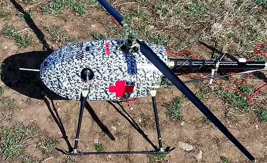
UAVOS has successfully tested its cargo delivery UVH-170 unmanned helicopter. The trial aimed to validate a highly automated delivery flight from a vendor to a destination and back, across precisely pre-selected pathways.
The flight took 1.7 hours and covered a standoff distance of 62 miles (100 kilometers). Critical humanitarian aid weighing 17.6 lbs (8 kg) was delivered with neither the need to land nor the need for a ground-control station on the receiving side.
UAVOS’s UAS is equipped with line-of-sight data link (LOS) and satellite communication data link, which supports beyond visual line of sight (BVLOS) flights. Watch the cargo delivery UVH-170 UAV in action.
UVH-170 unmanned helicopter is designed for commercial operations and immediate air response, emergency relief under demanding conditions and tight timescales. The aircraft’s high standoff distance makes it well-suited to humanitarian and disaster relief applications.
The capabilities of the UVH-170 unmanned helicopter address many social (medical, pharmaceutical, remote communities, humanitarian aid, etc.) and economic (mining, oil and gas, courier, etc.) use-cases being requested by customers.
The solution is based on the gasoline engine UVH-170 unmanned helicopter. With a maximum take off weight of 99 lb (45 kg), and a payload of up to 22 lb (10 kg), the UVH-170 flies at an altitude of less than 8,200 ft (2,500 m) at maximum speed of 74 mph (120 kph).
“As we have seen during the trials, the customers can derive significant benefits from the use of the UVH-170 UAV,” said Aliaksei Stratsilatau, CEO and Lead Developer of UAVOS. “As a robust VTOL platform, the UVH-170 does not require any additional take off or recovery equipment, which makes it perfect for delivery to remote areas. Besides, the unmanned helicopter has demonstrated capability to operate in windy conditions with gusts more than 14 mps.”
UAVOS has offices in Hong Kong, the United States and Europe. Among UAVOS’ unmanned technologies is the high-altitude pseudo-satellite (HAPS) ApusDuo, multi-platform autopilot solution for converting manned vehicles of all types into unmanned, and unmanned aerial vehicles aimed to counteract systems of electronic warfare.
Feature photo: UVH-170 unmanned helicopter is designed for immediate deliveries. (Photo: UAVOS)
With the rise in public unrest from COVID-19 and increasing numbers of remote operations, the susceptibility and vulnerability of a cyber attack has never been greater.
On a regular basis, we hear intelligence experts proselytize an eventual cyber doomsday where our critical infrastructure (CI) — communications systems, information technology (IT) capabilities and financial networks — are compromised or disabled. These kinds of attacks could devastate our national and economic security and even disrupt basic day-to-day activities like turning on lights or buying groceries with a debit card. Even worse, a significant cyber event could escalate to the point of military actions between nation-states.
In 2012, Defense Secretary Leon Panetta warned about a potential “Cyber Pearl Harbor.” These threats were echoed by then head of Cyber Command, Gen. Keith Alexander, with hope the public, private and CI sectors would take notice of the broad, detrimental impacts of cyber threats.
Geoff Hella, Centauri Corp.
In kind, the Obama administration took aggressive steps to protect CI networks, and the Trump White House followed suit by enacting measures to strengthen the resilience of other technologies integral to our CI.
The latest White House Executive Order specifically addresses our reliance on position, navigation and timing (PNT) services and directs agencies to work in close coordination with the private sector to identify, secure and continue to improve the resilience of these technologies.
PNT services, such as GPS, are an extension of our IT systems, but despite this, PNT has been a relatively invisible utility and is oftentimes unknowingly utilized by most CI owners and operators. In the coming years, our reliance on PNT will only increase, making now a critical time to foster close collaboration between public and private sectors and determine which systems, networks and assets are dependent on PNT services. Identifying these dependencies will allow us to verify appropriate resilient PNT services being used, determine downstream effects of the disruption and manipulation of PNT services, and manage the associated risks to dependent systems.
The new directive is fast paced — outlined in 90-, 180- and 360-day increments — and instructs agencies to utilize existing public-private sector cybersecurity and CI information sharing relationships, such as Sector Specific Agencies (SSA), to share threat data, educate stakeholders and promote a responsible use of PNT.
What’s the rush?
So, why is this happening right now? PNT systems are crucial to American life, and successfully securing them requires a coordinated response and sooner rather than later. In fact, malicious nation-states, such as Russia, are spreading their wings into new threat vectors to inflict damage and are shifting their attention to PNT.
Because of these risks, we must do more as a country to establish safeguards around these technologies. That being said, agencies and organizations cannot expect their current workforce to become PNT security experts overnight. Rather, business owners and operators would be better served bringing in third-party experts that have been building security into PNT even prior to this directive.
These private-sector partners can map out a systematic approach to prioritize PNT security in a three-step plan:
Find. Identify PNT systems and “profile” them — establish point A.
Fix. Find and correct vulnerabilities — many can be non-material/tactics, technique and procedures (TTP) solutions.
Fortify. Develop TTPs, timelines and guidance for users to upgrade CI where needed — the path to Point B.
When PNT services were first developed, the systems could be openly used by anyone and security was not built into the original PNT architecture — similar to when the internet was created. This has made it easy for adoption into almost everyday life and revolutionized the world. Likewise, it has also made it easy for bad actors to access and compromise it, forcing the country to scramble, backtrack and implement cybersecurity best practices.
The good news is that we aren’t completely starting from scratch. The Department of Defense has been working to secure its PNT systems and will be updating its processes and practices as part of the recent White House directive.
The security community can also look to best practices in assessing risk of vital systems and model PNT security measures on existing guidelines such as Federal Information Processing Standards (FIPS) and NIST Special Publication 800 Series.
Path Forward
Per the Executive Order, lead agencies such as the Department of Transportation and the Department of Commerce will work in concert with the private sector to define “PNT profiles” and share these attributes with stakeholders. The coalition of partners will then be able to account for where and how PNT is used by CI owners and operators and will promote the responsible use of PNT services moving forward.
Beyond defining PNT profiles, the EO allocates new research and development funding for Commerce to develop an alternative to GNSS, which provides real-time PNT data to planes, trains, ships and automobiles that transport vital goods and resources — all in an effort to reduce the level of acceptable risk.
The White House also requires the public and private sectors to develop vulnerability testing and incident response plans and, simultaneously, encourage the private sector to use and develop more robust PNT services in anticipation of new Federal Acquisition Regulatory Council (FARC) contract requirements.
While these changes may seem like a fast moving and overwhelming process, there are many cases where CI owners and operators will not be required to integrate material solutions, but rather procedural training and behavioral adjustments. The information sharing processes already exist to provide improved situational awareness, coordination among the public and private sectors, increased reporting, solidified baseline risk assessments and a broader understanding of how systems rely on PNT. The challenge is facilitating widespread adoption across all stakeholders, increasing collaboration and education among and across the CI groups.
For this effort to be successful, it will require a whole-community, multi-pronged approach to operating in a new “threat top-of-mind” paradigm that is grounded on cross-sector information sharing, training and education. Both public and private sectors should also outsource expertise and leverage existing models like the DoD PNT doctrine, NIST standards and incident response capabilities.
Gregory Gerten is director of PNT Operations at Centauri, supporting the PNT enterprise through innovative use of modeling and simulation, hardware-in-the-loop and field testing, and process automation. He earned his master’s degree in electrical engineering from the University of Dayton, and has completed post-graduate courses in GPS from the Air Force Institute of Technology. He has more than 20 years of experience in system design, development and integration in the areas of communications, navigation, electronic warfare tactics and weapon systems.
Geoffrey Hella is a senior engineer for Centauri assigned to a Space Command contract through the Joint Navigation Warfare Center (JNWC). He has worked to achieve a Master of Aeronautical Science (MAS) from Embry-Riddle Aeronautical University in 1994. During his 40 years of experience, he has been a leader in product development and system design to successfully carry out a vast range of assignments in multiple engineering disciplines. His assignments include: aircrew member of the United States Air force (USAF); National Air Space (NAS) engineer for the Federal Aviation Administration (FAA); Special Nuclear testing and safeguards engineer for the Department of Energy/Sandia National Laboratories; and Supervisory Control and Data Acquisition (SCADA) engineer for both public and private Industry, electric and gas utility companies. Hella currently holds a six-sigma certification and a general radio operator license from the Federal Communication Commission (FCC) and a remote pilot operator certificate from the Federal Aviation Administration (FAA).
The 2020 Galileo Masters are open for submissions. The competition is designed to award applications, services and new ideas that use Galileo and EGNOS, in synergy with other space programs, to respond to pressing needs facing business and society.
The 2020 competition has three European GNSS Agency (GSA) challenges, themed “Space for Future Generations.”
The first challenge, the “Space for our Planet Challenge,” aims to tackle climate change and environmental degradation. Services based on data from Galileo, EGNOS and Copernicus Earth observation can be used to mitigate this threat by supporting more environmentally-conscious life choices, resulting in a healthier planet, GSA said.
The second challenge, the “Space for Being Safe and Healthy Challenge,” seeks out solutions that use downstream space data provided by Galileo, EGNOS and/or Copernicus as key enablers of innovative applications to help stem the spread of COVID-19 pandemic.
The third challenge, the “Space for Fun Challenge,” targets solutions using data from Galileo and EGNOS in the gaming, sports, leisure and tourism markets, where GNSS enables the monitoring of user performance and helps make augmented reality games even more immersive.
For all three challenges, there is a cash price of 10,000€, with another 10,000€ awarded to the overall Galileo Masters 2020 winner.
Registration is free, and entries must be submitted by June 30.