According to the company, Trimble Dimensions is the signature event for Trimble’s global user community spanning agriculture, construction, geospatial, transportation, utilities and more. The show highlights technology and how it transforms the way professionals work to achieve success.
“Unfortunately, the overwhelming concerns and ongoing impact of COVID-19 inhibit our ability to deliver a conference that meets the high standards of safety and excellence our attendees expect and deserve,” Trimble said in a press release.
The event was scheduled to take place Nov. 2-4 at the Gaylord Opryland Resort and Convention Center in Nashville, Tennessee. Trimble Dimensions is a biennial event.
There’s no question that GPS is an essential service. The Second Space Operations Squadron (2 SOPS) is continuing to provide a global utility during the COVID-19 pandemic.
“No matter what, we need to ensure this mission continues so the American people and the world know they can depend on us to be the gold standard in precision navigation and timing,” said Lt. Col Stephen Toth, 2 SOPS commander. Services that use GPS include ambulances, hospitals, police departments and fire departments.
“It would make a global pandemic that much worse if we were to go down,” Toth said. “It could prevent a lot of the day-to-day things we rely on from happening, it could be catastrophic.”
GPS supports 14 of 16 essential industries in the United States. “We’ll remain reliable no matter what the condition the world is in,” Toth said. “Whether it be a pandemic, hurricane, tornado or any other type of crisis, we have plans and training for whatever threat we may face so the mission doesn’t stop.”
Unlike other jobs across the Department of Defense, those directly conducting operations can’t telework. They need to be in a sensitive compartmented information facility or restricted area in a secured area to access specific terminals and networks.
“The American people can count on space and they can count on our military to continue to provide the level of capability that’s expected no matter what’s going on in the world,” Toth said. “In times of crisis, people shouldn’t have to question whether we’ll be here or not, because we will and the mission won’t stop.”
Welcome to the Space Force
The official Space Force emblem was unveiled on Jan. 24.
Organized as a military service branch within the U.S. Department of the Air Force, the newly created Space Force has taken the reins of the GPS program.
Established on Dec. 20, 2019, under the Fiscal Year 2020 National Defense Authorization Act, the Space Force will be set up over the following 18 months. Commander of U.S. Space Command, Gen. John “Jay” Raymond, was sworn in Jan. 14 as the first chief of space operations of the U.S. Space Force, and is stationed at the Pentagon.
The same staff who have operated satellites and conducted space activities in the Air Force are continuing under the Space Force. Under the Space Force are the Space and Missile Systems Center at Los Angeles Air Force Base and the GPS Master Control Station, operated by the 50th Space Wing’s 2nd Space Operations Squadron (2 SOPS) at Schriever Air Force Base, Colorado. The 50th Space Wing is under Space Operations Command, located at Vandenberg Air Force Base, California.
25 years. The U.S. Space Force celebrated the 25th Anniversary of GPS reaching Full Operational Capability (FOC) on April 27, 2019. Over the past 25 years, GPS has become an integral technology that affects the lives of billions of people across the world.
Check out more case studies where GPS and inertial technology are supporting defense missions.
Featured image: U.S. Space Force / Kathryn Calvert; Capt. Jeff Wagner discusses a routine health check on a GPS satellite. 2 SOPS performs the command and control mission for the constellation.
According to AUVSI, the series will offer information, insights and insider knowledge covering a number of topics, including drone delivery, public safety, connectivity, and other aspects of the unmanned systems and robotics industry.
These webinars are being held because of the rescheduled Xponential 2020 conference. Xponential 2020 was originally scheduled to take place May 4-8 in Boston, but is now tentatively scheduled to take place Aug. 9-12.
AUVSI offered an overview of the webinars, which are all complimentary.
Digital Twins — The Future of Virtual and Mixed Reality Robotic Avatars Date: Monday, May 4, 3-4 p.m. EDT Speaker: Peter Haas, associate director, Humanity Centered Robotics Initiative, Brown University
Hass will describe how advances in mixed and virtual reality control will lead to a UX revolution for avatar-based robotic teleoperation, where the manipulation of digital twins will translate to manipulation of a robot — or robots — in the physical world. Register here.
Drone Delivery Supporting Public Health Date: Tuesday, May 5, 3-4 p.m. EDT Speakers: Eric Gardiner and Eric Lasker, federal business development, Zipline
Executives from Zipline will describe how drone delivery has evolved through the Federal Aviation Administration UAS Integration Pilot Program and is now being adapted to help community healthcare partners respond to COVID-19 in the United States. Register here.
NASA’s Vision and Role to Enable Urban Air Mobility Date: Wednesday, May 6, 3-4 p.m. EDT Speakers: Robert Pearce, associate administrator, NASA Aeronautics Research Mission Directorate, and Brian Wynne, president and CEO, AUVSI
Pearce will review initiatives to enable small UAS operating at low altitude through a UAS Traffic Management System and large UAS operating in higher altitude airspace with definitive flight experiments to validate key standards, such as detect-and-avoid technology. Wynne will host a discussion with Pearce about his full vision for future aviation, including what the next 50 years has in store for commercial airline travel and urban air mobility. Register here.
Advancing Autonomy Through DARPA Challenge to Benefit First Responders Date: Thursday, May 7, 3-4 p.m. EDT Speaker: Dr. Timothy Chung, program manager, DARPA Tactical Technology Office
DARPA’s Subterranean Challenge engages international teams to deploy autonomous systems — rolling, walking, flying and floating — to remotely map, identify and report on artifacts discovered along underground courses. Chung will discuss persisting challenges with robotics, how teams are succeeding in competition while advancing unmanned capabilities and how these lessons can benefit first responders. Register here.
Aerial Connectivity Joint Activity — Bridging the Gap Between Cellular and Aviation Date: Friday, May 8, 2-3 p.m. Speaker: Mark Davis, technical lead, ACJA
Davis will explore the latest roadmap for aviation and cellular communications, including how recent initiatives such as Aerial Connectivity Joint Activity (ACJA) are aimed at providing a standards framework to enable unmanned aerial cellular. ACJA is a joint activity between GSMA, which represents the interests of mobile operators worldwide, and the Global UTM Association, a non-profit consortium of worldwide Unmanned Aircraft Systems Traffic Management stakeholders. Register here.
An artist’s rendering of a Galileo satellite in orbit (Image: ESA)
News from the European Space Agency
As European governments plan their phased recoveries from the lockdown states triggered by the COVID-19 pandemic, the positioning delivered through satellite navigation is becoming more important than ever before, said the European Space Agency (ESA). Location is a key requirement when attempting to monitor and map the spread of a disease and satnav is one of the main tools supporting this, the agency added.
Since the outbreak of the coronavirus, many applications have been developed that use satnav-based location data to monitor the global spread of the virus and map outbreaks.
For example, Romanian company RISE developed an app called CovTrack, which monitors people in a user’s vicinity made identifiable via Bluetooth connections to the user’s mobile phone and stores the identification data of these devices.
By pressing a button, users can access the database in which the unique identifiers of the mobile phones are registered (without having access to any personal data of these mobile phone users), to verify whether the persons with whom users came in contact have subsequently been confirmed with COVID-19, ESA said. If users have identified a potential contact, they can refer to the relevant authorities whether that contact requires inclusion among the monitored persons, or even testing for COVID-19.
According to ESA, CovTrack, developed on a pro-bono basis, is a spin-off from the existing AGORA project for festival management, supported through ESA’s Navigation Innovation and Support Programme, focused on future navigation technologies.
ESA, along with the European Global Navigation Satellite System Agency (GSA) and European Commission, put together a repository of these apps. The list, based on apps that are already working and available in app stores, includes practical apps that facilitate the daily lives of citizens. Check out the list here.
Europe’s Galileo, currently embedded in over 1.3 billion smartphones and devices worldwide, is helping to increase satnav accuracy and availability, especially in urban areas, ESA added.
In addition, GSA is developing its own Galileo-enabled application, Galileo for Green Lane, to monitor and ease the circulation of goods between European Union (EU) Member States while identifying potential congestion at Green Lane border crossings, thus ensuring EU citizens can access the needed supplies of critical goods.
Drone maker Parrot is supporting French medical professionals facing the COVID-19 pandemic by helping Makers for Life design the MakAir respirator. This partnership comes as a part of their MakAir open source respirator project.
According to Parrot, it will be offering 500 engines for the launch of the MakAir project and will ultimately make 5,000 engines for the project. The engines will offer constant power, controlled vibrations, sufficient reliability and endurance to allow 24/7 operation for six weeks, Parrot added.
The MakAir project came to life when the COVID-19 pandemic highlighted a shortage of artificial respirators. Two other projects joined the cause to alleviate this issue. The first project, which brought together a number of manufacturers, was coordinated by Air Liquide and aims to increase the production of artificial respirators from 200 to 10,000 per year, starting in May 2020.
A second nonprofit project has spurred initiatives to create a simplified artificial respirator from standard components. Quentin Adam of the Makers For Life collective, in collaboration with Professors Antoine Roquilly and Pierre-Antoine Gourraud of the Faculty of Medicine of Nantes, and Erwan L’Her, head of the Intensive Medicine and Care Department of the Brest CHU, proposed a concept for a simplified artificial respirator.
The concept is based on using software to regulate inspiration-expiration, directly with the pneumatic system. The Nantes developer team turned to the CEA for industrialization of the concept, which had already been the subject of a proof of concept at the Brest University Hospital.
Parrot reaches milestone in U.S. Army Short-Range Reconnaissance drone program
Parrot has passed another milestone in the United States Army’s Short Range Reconnaissance drone program. As the final steps of this selection process, Parrot will participate in an operational assessment to support an Army production award decision. In anticipation of an increased demand signal from the Department of Defense, Parrot will start manufacturing prototypes of its dedicated drone in the United States, the company said.
“Parrot is honored to work with the DoD on this highly strategic project,” said Laurent Rouchon, vice president of security and defense at Parrot. “We have successfully met the high standards set over the last 12 months on the prototype efforts, and we look forward to entering this final phase and launching production in the USA.”
One industry important to the world’s fight and recovery from the COVID-19 pandemic is geospatial analytics. In response, the World Geospatial Industry Council (WGIC) has created an information hub for COVID-19 information.
“These are very uniquely challenging times for our industry. At the same time, our industry has stood up to assist the world, especially the key decision-makers and frontline workers to understand the scenarios on the ground,” said Harsha Vardhan, WGIC associate director. “Spatial analytics-based decision making has come to the forefront during these times.”
Governments are using location tracking in combination with personal data to track and combat COVID-19, and the use of location technology in conjunction with personal data is of high relevance and usage, Vardhan said. “This scenario brings before us the aspects of data privacy, data protection, and the role of geospatial information.”
In March, WGIC published a report titled “Geospatial Information and Privacy: Policy Perspectives and Imperatives for the Geospatial Industry.” Vardhan said the report is even more significant now. WGIC is hosting a webinar on the report on May 14 at 11 a.m. ET.
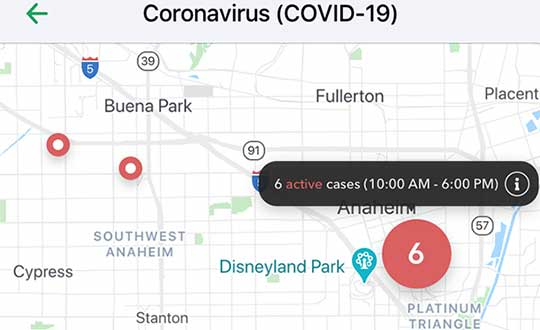
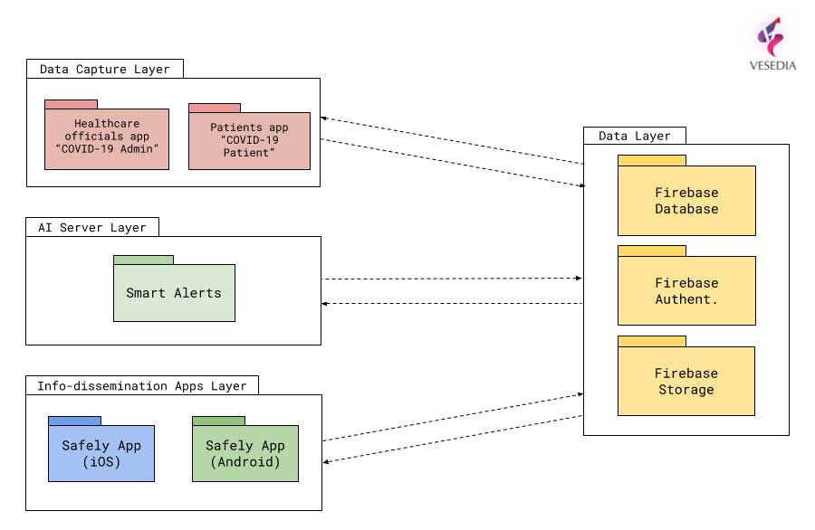
Vesedia Mobile Technologies is offering to deploy its location platform to help control the COVID-19 pandemic through tracking and dissemination of information about “at risk” infection areas and places, and times when they were known to have infection — a process referred to as contact tracing.
Vesedia is a technology startup with a suite of mobile apps for children and family safety based on a location-sharing platform and location-tracking artificial intelligence (AI).
“The platform would warn people that passed through these places at matching times,” explained Ruslan Shalaev, co-founder and team leader, Vesedia. Shalaev developed a popular app for family safety: Safely – Family Location; and serves as a lead research on user-location monitoring AI in an academic partnership with Binghamton University and Lviv National University.
The Safely – Family Location app could be used to disseminate data on infection areas, and access to the API would be provided for other application developers and sites, Shalaev said.
The platform would be applicable after the initial pandemic is contained. “It would help with restarting the economy and resuming normal business operations by providing a mechanism to track, control and suppress new outbreaks,” Shalaev said.
Data Sources
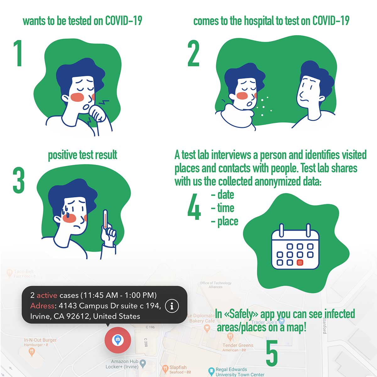
Under the plan, people that test positive to COVID-19 would be asked to provide information about public places they visited in the preceding days, and at what times. Individuals that provide the information can confirm that it’s accurate from their phone location history.
The information would be anonymized by healthcare officials, and entered into a database that would be publicly accessible via a website and mobile app.
Image: Vesedia
Mobile App
The mobile app aspect is especially valuable from information dissemination standpoint, because other people in “at risk” areas can receive automated alerts to self-quarantine and get tested based on their device location history.
The app is ready and available for download in Google Play and Apple App Store.
Image: Vesedia
Image: Vesedia
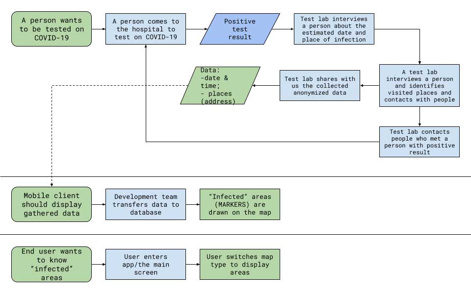
Workflow diagram
Workflow diagram. (Image: Vesedia)
System architecture
System architecture. (Image: Vesedia)
Approach validity
The approach has been successfully applied in Singapore, but without active alerts, with dissemination of information being done manually. The Singapore government was able to contain the virus without shutting down businesses, schools, public transit and restaurants.
Vesedia location apps
Vesedia is a tech startup founded in 2016 by SUNY Binghamton Computer Science graduates. It developed SmartAI location tracking and sharing platform. Its apps include Safely – Family Location, Virtual Nanny, MeetCity – Live Events, Blind Date, Sponter – Social Network in partnership with Lviv National University and Binghamton University. The apps are available for download in the Google Play and Apple App stores.
Vesedia research on “Location-Based Behavioral Patterns Modeling” was published at Institute of Electrical and Electronics Engineers – Intelligent Data Acquisition and Advanced Computing Systems (IEEE/IDAACS) conference in Metz, France in 2019.
The North Carolina Department of Transportation (NCDOT) is working with public and private partners to launch three projects using drones to aid in COVID-19 relief efforts. According to NCDOT, the initiative will be launched in May.
For the first project, Novant Health and Zipline are proposing to deliver personal protective equipment and other medical equipment across Novant Health’s medical campuses in the Charlotte area.
For the second project, UPS Flight Forward and Matternet are proposing to work with a Winston-Salem hospital on an operation to use drones to take healthcare equipment, medicine and personal protective equipment to medical providers. UPS Flight Forward, which earned the necessary federal certifications to operate a drone airline, has an ongoing drone delivery service at WakeMed’s main campus in Raleigh, NCDOT said.
Finally, for the third project, Flytrex is proposing to deliver food from multiple restaurants in a shopping center to neighborhoods in the Holly Springs area.
The first two programs are aimed at reducing the strain on medical supply chains, and the third will make it easier for people to follow the stay-at-home order. According to NCDOT, officials will use data collected during the project to determine how this technology can be used in other areas of the country.
“North Carolina has been a leader in demonstrating how drones can help people in times of crisis,” said State Transportation Secretary Eric Boyette. “We look forward to putting this technology into productive use as we work to help citizens and medical professionals during the COVID-19 pandemic.”
Funding for the individual drone missions is coming from private partners, while NCODT is coordinating the initiative.
New hyperlocal business directory ZoomBusiness designed to help Main Street businesses across North America engage with local residents
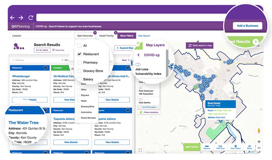
GIS Planning has launched an online tool that enables local businesses across North America to communicate with customers for free in real time.
ZoomBusiness, created in response to the COVID-19 pandemic, is an interactive, mobile-responsive mapping directory for communities that ensures customers can find open restaurants, stores and services in their region at no charge.
Businesses can list themselves for free on their local ZoomBusiness site, hosted by economic development organizations like cities, towns, counties or chambers of commerce. The businesses can provide customized details including websites, modified hours, delivery or curbside pickup options, promotions and gift card stimulus programs.
Residents can search for area businesses by categories, including grocery stores, pharmacies, banks, health facilities, hardware stores, pet stores and automotive shops, among others.
North America deployment
Local ZoomBusiness sites have already been deployed in more than 20 communities across North America during its soft launch, including regions of eastern Pennsylvania;, the City of Columbia, South Carolina; the state of Wyoming (which has listed more than 600 businesses on the directory); and Abbotsford, British Columbia.
“We created ZoomBusiness after realizing that small businesses need new, accurate ways to communicate that they are still open to their customers, given that social distancing requirements, product availability and operating hours are changing by the day,” said Pablo Monzon, managing director and co-founder, GIS Planning. “Our development team has created an intuitive tool to index and map business information across North America in real-time, and we believe it will be an enormous resource for the communities we serve.”
ZoomBusiness is a simple-to-use data tool, powered by Google Maps, using various layers for precise queries. Businesses are prompted to directly enter information on their current status and the content is verified by the organization hosting the GIS tool.
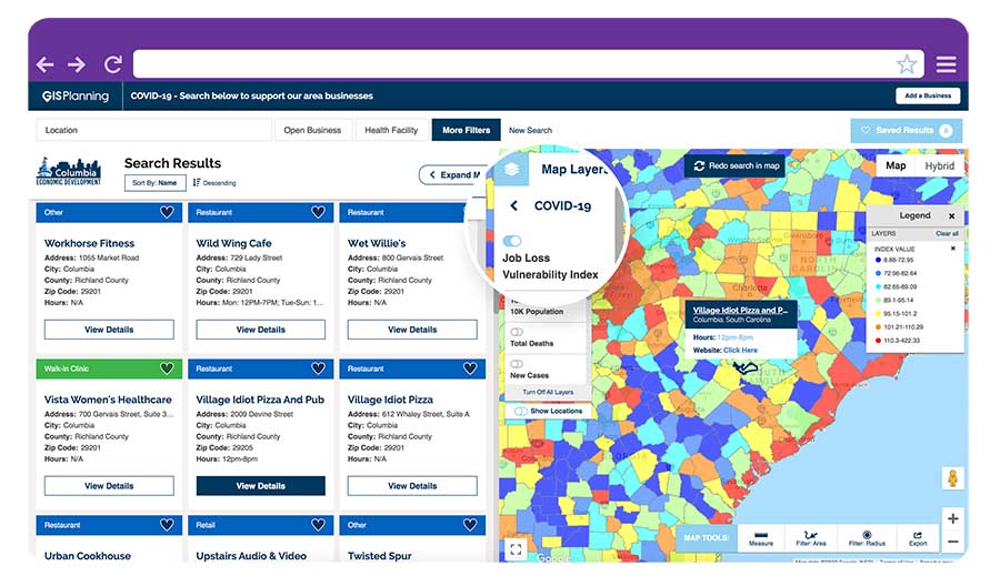
GIS Planning also added free map layers, including a COVID-19 case map updated daily by the New York Times, and a job-loss vulnerability index using recent employment data from Chmura.
Screenshot: GIS Planning
Columbia, South Carolina
The city of Columbia features 180 businesses on ZoomBusiness, helping residents discover delivery and curbside food options. That number is expected to quickly rise to more than 300 as business owners input data. Columbia will continue to promote safe and responsible “Shop Local” practices, Coleman added, in hopes that residents will take advantage of the service and support local businesses.
“Through our work with GIS Planning, we’ve been able to take our list of open restaurants and businesses and integrate it into the available properties map on our website,” said Ryan Coleman, director of the City of Columbia Office of Economic Development. “During this crisis, local businesses need every advantage we can give them, and this is another tool in their arsenal in helping to mitigate the negative impact of COVID-19.”
Abbotsford, British Columbia
The new solution has also made an impact in Canada, including the City of Abbotsford, British Columbia, which is promoting 130 businesses ranging from grocers to auto shops and medical suppliers.
“This is a resource that fills an urgent need. The long-term health and security of our businesses depend, in part, on the decisions we’re making right now,” said Kim O’Sullivan, City of Abbotsford’s economic development coordinator. “ZoomBusiness allows owners to communicate directly with their customers, many of whom would frequent these businesses, even online, if they knew they were able to do so.”
ZoomBusiness clients are given a unique link to their region which is then shared across organizational websites and social media to reach residents.
“Main Street businesses are truly the lifeblood of a community,” said Alissa Sklar, vice president of marketing for GIS Planning. “According to FEMA, up to 40% of small businesses never reopen after a major disaster. With ZoomBusiness, we want to help make sure the local restaurants, retailers and service providers that define local communities are still there to serve area residents when this pandemic is over.”
GIS Planning has made its ZoomBusiness tool free for its existing economic development clients (those using its investment attraction map, ZoomProspector); it is also available to new clients for a nominal fee. Prices are indexed to population size to keep them affordable for all communities. New clients can also be set up and ready to launch the tool within one day.
Following the COVID-19 recovery, data experts at GIS Planning forecast continued use of the directory to promote small and medium-sized businesses across North America.
New hyperlocal business directory ZoomBusiness designed to help Main Street businesses across North America engage with local residents
GIS Planning has launched an online tool that enables local businesses across North America to communicate with customers for free in real time.
ZoomBusiness, created in response to the COVID-19 pandemic, is an interactive, mobile-responsive mapping directory for communities that ensures customers can find open restaurants, stores and services in their region at no charge.
Businesses can list themselves for free on their local ZoomBusiness site, hosted by economic development organizations like cities, towns, counties or chambers of commerce. The businesses can provide customized details including websites, modified hours, delivery or curbside pickup options, promotions and gift card stimulus programs.
Residents can search for area businesses by categories, including grocery stores, pharmacies, banks, health facilities, hardware stores, pet stores and automotive shops, among others.
North America deployment
Local ZoomBusiness sites have already been deployed in more than 20 communities across North America during its soft launch, including regions of eastern Pennsylvania;, the City of Columbia, South Carolina; the state of Wyoming (which has listed more than 600 businesses on the directory); and Abbotsford, British Columbia.
“We created ZoomBusiness after realizing that small businesses need new, accurate ways to communicate that they are still open to their customers, given that social distancing requirements, product availability and operating hours are changing by the day,” said Pablo Monzon, managing director and co-founder, GIS Planning. “Our development team has created an intuitive tool to index and map business information across North America in real-time, and we believe it will be an enormous resource for the communities we serve.”
ZoomBusiness is a simple-to-use data tool, powered by Google Maps, using various layers for precise queries. Businesses are prompted to directly enter information on their current status and the content is verified by the organization hosting the GIS tool.
GIS Planning also added free map layers, including a COVID-19 case map updated daily by the New York Times, and a job-loss vulnerability index using recent employment data from Chmura.
Screenshot: GIS Planning
Columbia, South Carolina
The city of Columbia features 180 businesses on ZoomBusiness, helping residents discover delivery and curbside food options. That number is expected to quickly rise to more than 300 as business owners input data. Columbia will continue to promote safe and responsible “Shop Local” practices, Coleman added, in hopes that residents will take advantage of the service and support local businesses.
“Through our work with GIS Planning, we’ve been able to take our list of open restaurants and businesses and integrate it into the available properties map on our website,” said Ryan Coleman, director of the City of Columbia Office of Economic Development. “During this crisis, local businesses need every advantage we can give them, and this is another tool in their arsenal in helping to mitigate the negative impact of COVID-19.”
Abbotsford, British Columbia
The new solution has also made an impact in Canada, including the City of Abbotsford, British Columbia, which is promoting 130 businesses ranging from grocers to auto shops and medical suppliers.
“This is a resource that fills an urgent need. The long-term health and security of our businesses depend, in part, on the decisions we’re making right now,” said Kim O’Sullivan, City of Abbotsford’s economic development coordinator. “ZoomBusiness allows owners to communicate directly with their customers, many of whom would frequent these businesses, even online, if they knew they were able to do so.”
ZoomBusiness clients are given a unique link to their region which is then shared across organizational websites and social media to reach residents.
“Main Street businesses are truly the lifeblood of a community,” said Alissa Sklar, vice president of marketing for GIS Planning. “According to FEMA, up to 40% of small businesses never reopen after a major disaster. With ZoomBusiness, we want to help make sure the local restaurants, retailers and service providers that define local communities are still there to serve area residents when this pandemic is over.”
GIS Planning has made its ZoomBusiness tool free for its existing economic development clients (those using its investment attraction map, ZoomProspector); it is also available to new clients for a nominal fee. Prices are indexed to population size to keep them affordable for all communities. New clients can also be set up and ready to launch the tool within one day.
Following the COVID-19 recovery, data experts at GIS Planning forecast continued use of the directory to promote small and medium-sized businesses across North America.
The Esri User Conference, which usually takes place in San Diego in July, will this year be held virtually.
“As a result of the coronavirus disease 2019 (COVID-19) crisis, we are making the decision to move the 2020 Esri User Conference in San Diego to a virtual format. This is a great disappointment to me personally, as I know it will be for many of you,” Esri CEO Jack Dangermond told those planning to attend in an April 22 e-mail.
The following is an outline of Esri’s current plan, with more information available in the Esri UC FAQs:
The event will take place July 13–15, 2020.
The plenary session, technical workshops and Esri Showcase will be virtual, featuring many demonstrations and live discussions during the conference.
There will be many opportunities for networking, collaboration and real-time interaction with Esri experts and staff.
User presentations and the map gallery will be featured digitally.
A library of recorded sessions and demos will be created and kept available as an ongoing resource.
Registration will be complimentary for all Esri customers who are current on their maintenance or subscription.
“Forty years ago this month, we had our first User Conference in Redlands, California, with only a handful of participants,” Dangermond wrote. “While initially no one was quite sure of what the outcome would be, the event started an ongoing tradition where Esri and our users would come together, share our work, learn and create a community of common interests.
“That first meeting on the Esri campus provided the groundwork for the annual event at which thousands of professionals from every corner of the globe meet one another, share inspiring examples of work and learn from each other’s experiences.
“While we can’t replicate the experience of being together in person, we will do our best to create an amazing event that will continue to move you and our community forward. One of the benefits of going with a virtual format will be that organizations will be able to send an unlimited number of attendees.”
The USGIF Awards Program annually recognizes the exceptional work of the geospatial intelligence (GEOINT) tradecraft’s brightest minds and organizations pushing the community forward.
Award winners are usually recognized at the annual GEOINT Symposium. This year’s event, scheduled for April 26-29 in Tampa, Florida, was canceled because of the COVID-19 pandemic.
“Unfortunately, you will not see the awardees recognized on the GEOINT Symposium stage this year,” said Kevin Jackson, chair of the USGIF Awards Subcommittee. “So please take a moment to read their accomplishments and join me and the USGIF in congratulating the 2020 USGIF Achievement Awardees and the runners-up.”
Award winners are nominated by their colleagues and selected by the USGIF Awards Subcommittee.
“The 2020 USGIF awardees reflect the importance and the significance of the outstanding work that occurs daily in the GEOINT community,” Jackson said. “You will see how the GEOINT community always rises to the occasion to face head on the world’s toughest problems and this year is no exception.”
Academic
James Martin Center for Nonproliferation Studies, Middlebury Institute
On Dec. 7, 2019, after denuclearization negotiations between the United States and North Korea collapsed, North Korea reversed commitments made in Singapore and resumed engine testing at its Sohae Satellite Launch Center. Using new technological opportunities offered by high-cadence moderate resolution satellite imagery and flexible high-resolution satellite image tasking provided by Planet Labs, analysts at the CNS, through the use of open-source GEOINT, detected and correctly identified preparations for the engine test 39 hours before it occurred. Announcing in advance that North Korea was preparing to violate an international nonproliferation commitment.
Community Support
NGA Expeditionary Operations Office
NGA’s Office of Expeditionary Operations provides deployed personnel and technology to support GEOINT activities of worldwide U.S. military operations, humanitarian assistance and disaster relief efforts, and other national security objectives. The team’s world-class workforce seamlessly enables trusted global GEOINT capabilities today, while developing programs and processes to meet emerging challenges. Robust partnerships with DoD and IC allies fuel innovation and expertise, helping U.S. and foreign partners build programs that anticipate their needs, expanding the GEOINT community and optimizing meaningful consequence across the GEOINT enterprise.
Government
Mark A. Skoog and Loyd R. Hook
Implementing digital terrain solutions for safer aviation has been a career-long goal for Mark Skoog and Loyd Hook. As true innovators and lifelong proponents of using digital terrain data, Skoog and Hook lead the development efforts of NASA’s award-winning Automatic Ground Collision Avoidance System (Auto GCAS), which prevents imminent collisions with the ground. Auto GCAS is the culmination of a decades-long effort to bring geospatial intelligence to aircraft safety. This work involved traveling the world, evaluating myriad digital terrain from Sweden to Hawaii. The team extensively tested the system to ensure against every category of controlled flight into terrain mishaps—and found it would have prevented every one, which resulted in ten lives saved thus far in the USAF operations.
Industry
Lockheed Martin Space GATR Team
Globally-scalable Automated Target Recognition (GATR) is an artificial intelligence system that finds objects of interest in satellite imagery on a worldwide basis. It was developed by a team of scientists and engineers from Lockheed Martin Space who combined state-of-the-art deep learning algorithms with scalable high-performance computing in a cloud-based framework to achieve high-speed global automated target recognition (ATR). Unlike other ATR systems, GATR searches extremely large geographic regions with accuracy and speed. The GATR team, led by Dr. Mark Pritt, includes Tyler Bartelmo, Gary Chern, Dr. Austen Groener, Michael Harner, Andy Lam, Stephen O’Neill, Ryan Soldin, and Steve Wozniak.
Military
RS/GIS CX, The GRiD Team
David Finnegan and the Geospatial Repository & Data Management System (GRiD) program provide the Department of Defense (DoD), intelligence community and geospatial community with a centralized repository for the storage, discovery, and dissemination of critical terrain and 3D data. Prior to the GRiD program, the National System for Geospatial Intelligence (NSG) lacked a centralized mechanism for the storage and discovery of this essential content. Historically, the data was subject to local storage, limiting visibility and resulting in retasking collection assets for previously characterized areas, putting military personnel and equipment at risk. By partnering with the National Geospatial-Intelligence Agency (NGA) and the DoD, the GRiD program is now the community standard and enterprise solution for 3D/elevation data discovery across the NSG.
USGIF, the United States Geospatial Intelligence Foundation, is dedicated to bringing together the many disciplines involved in GEOINT to exchange ideas, share best practices and promote the education and importance of a national geospatial intelligence agenda. For more on the awards program, visit the USGIF website.