Tag: defense

  • Emcore’s new EN-2000 micro INS ready for defense, UAVs

    Emcore’s new EN-2000 micro INS ready for defense, UAVs

    Photo: Emcore
    Photo: Emcore

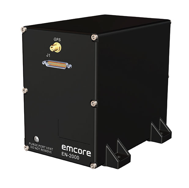
    Emcore Corporation has launched the EN-2000 to the Emcore-Orion series of micro-inertial navigation (MINAV) systems.

    The new EN-2000 will represent the pinnacle of performance in Emcore navigation systems, and realizes the company’s vision of a closed-loop, solid-state design that will deliver higher performance at lower cost than traditional RLG (ring laser gyroscope) navigation systems.

    The EN-2000 expands Emcore’s navigation systems line that also includes the EN-1000 introduced in 2017. The Emcore-Orion series of inertial navigation system (INS) are designed for use in a broad range of defense, aviation and aeronautics applications.

    The unit was introduced at the Paris Air Show, held June 17-20 at the Parc des Expositions Paris-le Bourget in Hall 6, Stand #C65.

    Today, there is an ever-increasing premium being placed on modern navigation systems for improved size, weight and power (SWaP). Traditional RLG navigation systems placed a premium on accuracy and performance, but not SWaP. Typical RLG and FOG systems are large and heavy, ranging in volume from 330 in3 to 540 in3, weighing 13 to 22 pounds with power requirements of 25 to 38 watts.

    Many modern weapon systems are now remotely operated, unmanned or man-portable and may need to operate where GPS is unavailable or denied. The compact EN-2000 is designed for these applications. It puts a premium on accuracy and performance, but also on smaller size, less weight and lower power consumption.

    The new Emcore-Orion EN-2000 MINAV is a three-axis design using the company’s proprietary, next-generation solid-state optical transceiver with advanced integrated optics, combined with all new field programmable gate array (FPGA) electronics to deliver stand-alone aircraft-grade navigator performance at one-third the SWaP of legacy or competing systems.

    The EN-2000 model comes in two standard versions, an IMU version and a standalone INS configuration. The INS version can gyrocompass to less than 0.7 milliradians and maintain near-GPS-level positional accuracy without the use of a GPS receiver. This makes it suitable for use in GPS-denied environments.

    To provide customers with additional flexibility, the unit is also capable of being aided by an external GPS for applications where needed.

    The Emcore-Orion EN-2000 is compact and lightweight, weighing less than 7 pounds, with very low power consumption of 10 watts. It can deliver twice the performance of the EN-1000 with the same form factor.

    The low SWaP of the EN-2000 makes it a suitable inertial navigation system for unmanned aerial vehicles (UAVs), unmanned underwater vehicles (UUVs), unmanned ground vehicles (UGVs), manned aircraft, rotorcraft and dismounted soldier applications.

    “With the introduction of the EN-2000, Emcore can now offer class-leading performance at a fraction of the size, weight and power of competing systems with increased reliability,” said David Faulkner, Emcore vice president and general manager of aerospace and defense. “Emcore’s goal of a true full navigation system that can replace older technology navigation systems in UAVs, UUVs, UGVs, manned aircraft and rotorcraft is fully realized with the introduction of the EN-2000.”

    “Our Emcore-Orion series micro navigators improve dramatically on the size and cost of navigation and azimuth sensing equipment by utilizing affordable lightweight sensors that reduce overall system weight and increase accuracy,” added K.K. Wong, Sr., director of fiber optic gyro products for Emcore. “The digital interface is also fully programmable at Emcore’s factory enabling it to directly replace competing units.”

  • NovAtel reduces size of anti-jam GAJT

    NovAtel reduces size of anti-jam GAJT

    NovAtel has added the GAJT-410ML to its GPS Anti-Jam Technology (GAJT) portfolio. Designed specifically for rapid integration into space-constrained military land applications, the easy-to-use system protects GPS-based navigation and precise timing receivers, including M-code, from both intentional and accidental interference, the company said.

    The GAJT-410ML is the next evolution of NovAtel’s battle-proven anti-jam technology. It maintains the high levels of interference rejection performance as in the larger GAJT-710ML system, but in a lower size, weight and power (SWaP) design.

    Photo: NovAtel
    Photo: NovAtel

    Working alongside the GAJT-410ML, the Power Injector Data Converter (PIDCTM) provides access to the jammer status and direction-finding (DF) information. It also provides clean power and data over the same cable that delivers the protected GPS signal back to the receiver, which reduces the need for costly platform modifications. The PIDC can be supplied in either an enclosure or board and is available to license for installation into third-party equipment.

    NovAtel Defence Segment Manager Dean Kemp noted, “Building on the success of our existing anti-jam portfolio, the GAJT-410ML is the first system to address the needs of smaller land-based platforms and add situational awareness capability to already high levels of mitigation performance.”

    “This product offers more choices for system integrators and end users to protect against GPS denied or constrained situations and delivers on our commitment to provide assured positioning anywhere,” Kemp added.

    Learn more about the GAJT-410ML anti-jam antenna or talk with NovAtel’s team of specialists at these upcoming trade shows:

    • The Special Operations Forces Industry Conference (SOFIC) – May 20 – 23, 2019, Tampa, FL USA
    • CANSEC – May 29 – 30, 2019, Ottawa, ON Canada
    • Joint Navigation Conference (JNC) – July 8 – 11, 2019, Long Beach, CA USA
    • International Defence Industry Exhibition MSPO (Canadian Pavilion) – September 3 – 6, 2019, Kielce, Poland
    • Defence & Security Equipment International (DSEI) – September 10 – 13, 2019, London, UK
  • Hexagon Geospatial releases Luciad Portfolio update

    Logo: HexagonHexagon’s Geospatial Division has released V2018.1 of the Luciad Portfolio. According to the company, V2018.1 focuses on further expanding 3D capabilities and includes additional data formats and standards for users in military and maritime domains.

    To accomodate organizations’ expanding geospatial data, LuciadFusion added a RESTful API to automate the entire process of data crawling.

    As a part of the update, LuciadFusion and LuciadLightspeed, the server and desktop solutions, have added support for the E57 point cloud format and automate point cloud data optimization through the Tiling Engine API. LuciadLightspeed now includes inland electronic navigational charts and updated support for military symbology with the U.S. Department of Defense Joint Military Symbology Standard and the NATO Joint Military Symbology Standard APP-6D icons.

    In addition, LuciadRIA now allows users to draw a multitude of complex lines and military tactical graphics in 2D and 3D in the browser.

    “The additional 3D capabilities of Luciad V2018.1 support our vision for a smart digital reality, empowering users to unlock the power of advanced geospatial analytics and visualizations,” said Mladen Stojic, president of Hexagon’s Geospatial Division.

  • GAO targets DoD cyber vulnerability

    GAO targets DoD cyber vulnerability

    In a 50-page report to the U.S. Senate Armed Services Committee, the government’s General Accounting Office (GAO) finds that U.S. weapons systems are, almost across the board, highly vulnerable to cyber-attack. Furthermore, the Department of Defense (DoD) has gotten off to “a late start” in prioritizing cybersecurity, and has only “a nascent understanding” of how to develop more protected weapons systems. The October 2018 report, “Weapons Systems Cybersecurity,” is subtitled “DoD Just Beginning to Grapple with Scale of Vulnerabilities.”

    [Image above: Figure 2 from the GAO report: Embedded Software and Information Technology Systems Are Pervasive in Weapon Systems, represented via Fictitious Weapon System for Classification Reasons). Source: GAO analysis of Department of Defense information, GAO-19-128.]

    GPS can figure to be among these threatened systems, and GPS guidance aboard many munitions and almost all platforms vastly expands the danger. The satnav system is not mentioned by name in the report (“To present information in an unclassified format, we do not disclose details regarding weapon system vulnerabilities, which program offices we interviewed, or which cybersecurity assessments we reviewed.”), and the word navigation surfaces only once, but it’s an alarming appearance:

    “Weapon systems are dependent on external systems, such as positioning and navigation systems and command and control systems in order to carry out their missions—and their missions can be compromised by attacks on those other systems. A successful attack on one of the systems the weapon depends on can potentially limit the weapon’s effectiveness, prevent it from achieving its mission, or even cause physical damage and loss of life.”

    The latter scenario could occur if a GPS-guided armament were hacked and rerouted to a civilian target, for example.

    The GAO states that it warned as far back as 2015, and in repeated instances since that date, that federal and contractor systems face an evolving array of cyber-based threats, including criminals, hackers, adversarial nations, and terrorists. “Threats can range from relatively unskilled “script kiddies” who only use existing computer scripts or code to hack into computers, to well-resourced and highly skilled advanced threats who not only have sophisticated hacking skills, but also normally gather detailed knowledge of the systems they attack.”

    Networks, Computers Increase Vulnerabilty

    The increasingly computerized and networked nature of the U.S. military’s weapons contributes to their vulnerability. As weapon systems become more software- and IT-dependent and more networked, they actually become more vulnerable to cyber-invasion. Networks can be used as a pathway from one accessed weapon to attack other systems.

    “Nevertheless,” the report adds, “until recently, DOD did not prioritize cybersecurity in weapon systems acquisitions. . . . DOD is in the early stage of trying to understand how to apply cybersecurity to weapon systems.”

    As the GPS constellation — the satellites themselves as well as the ground control system — become more software-reliant, including the ability to modify signals by remote software command, this has to be a growing concern for the U.S. Air Force. Difficulties with cyber-proofing the next-generation ground control system, OCX, have been suspected as a leading cause of extended delivery delay in that program.

    DoD officials reportedly confided that it will take time — and possibly some missteps — to learn what does and does not work in combatting cyber-attacks on weapon systems.

    Separately, a UK defense expert consultant stated that Russia had “stolen a march on using cyber-capabilities at a tactical level on the battlefield.” As reported last year in GPS World, Black Sea spoofing incidents aroused suspicion that Russia was testing a new counter-combat technique.

    Another spoofing expert said at the time, “It’s long been assumed that Russia, China and other nations (including the U.S.) have the technology to carry out a spoofing attack. What’s surprising is Russia’s willingness to use it openly and somewhat indiscriminately. It does fit nicely into what has been called Russian disinformation technology.”

    Figure 3 from the GAO report: Weapons Include Numerous Interfaces That Can Be Used as Pathways to Access the System (Represented via Fictitious Weapon System for Classification Reasons) Source: GAO analysis of Department of Defense information, GAO-19-128.
    Figure 3 from the GAO report: Weapons Include Numerous Interfaces That Can Be Used as Pathways to Access the System (Represented via Fictitious Weapon System for Classification Reasons) Source: GAO analysis of Department of Defense information, GAO-19-128.

    The amount of software embedded in weapon systems and subsystems has increased exponentially, expanding the respective weapons’ vulnerable surfaces. According to the military’s Director of Operational Test and Evaluation, “any exchange of information is a potential access point for an adversary. Even “air gapped” systems that do not directly connect to the Internet for security reasons could potentially be accessed by other means, such as USB devices and compact discs. Weapon systems have a wide variety of interfaces, some of which are not obvious, that could be used as pathways for adversaries to access the systems, as is shown in Figure 3.”

    If attackers can access one of those systems, they may be able to reach any of the others through connecting networks.

    Figure 4 from the GAO report: Weapon Systems Are Connected to Networks That May Connect to Many Other Systems (Notional Depiction for Classification Reasons)

    Further, the DOT&E found that some networks were not survivable — that is, able to maintain critical capabilities under applicable threat — in a cyber-contested environment.  The Defense Science Board concluded in 2013 that “the adversary is in our networks.”

    The GAO adds that it and other organizations have been sounding off about such threats since the early 1990s — around the time that GPS itself became operational.

    Tests of major military programs conducted between 2012 and 2017 revealed mission-critical cyber vulnerabilities that adversaries could compromise. “Test teams were able to gain unauthorized access and take full or partial control of these weapon systems in a short amount of time using relatively simple tools and techniques. . . . Once they gained initial access, test teams were often able to move throughout a system, escalating their privileges until they had taken full or partial control of a system.”

    Figure 5: Vulnerabilities that the Department of Defense Is Aware of Likely Represent a Small Amount of Actual Vulnerabilities Due to Limitations in Cybersecurity Testing. Source: GAO analysis of Department of Defense information, GAO-19-128.
    Figure 5: Vulnerabilities that the Department of Defense Is Aware of Likely Represent a Small Amount of Actual Vulnerabilities Due to Limitations in Cybersecurity Testing. Source: GAO analysis of Department of Defense information, GAO-19-128.

    Beginning Steps

    The Department of Defense is “still learning” how to address weapon system security and “still determining” what steps it may take. Implementation, once identified, will surely occupy an extended period. Complicating the picture, if DOD is able to make its newer systems more secure, yet connects them to older, vulnerable systems, the newer systems come into jeopardy.

    Pass the Hash

    A report appendix lists several different types of attacks with such pictorial names as: Man-in-the middle, Pass-the-hash, War driving, and Zero day exploit.

    Respectively, these types of attacks connote:

    • An eavesdropping attack in which the attacker intercepts to read or modify data communications to masquerade as one or more of the entities involved.
    • Capturing an encrypted version of a username and password in order to authenticate to a server or service. The attacker does not have to decrypt the username and password (i.e., they do not actually know what they are), yet can still use them to log in to a system.
    • Driving through cities and neighborhoods with a wireless-equipped computer — sometimes with a powerful antenna — searching for wireless networks potentially to exploit.
    • Taking advantage of a security vulnerability previously unknown to the general public. In many cases, the exploit code is written by the same person who discovered the vulnerability. By writing an exploit for the previously unknown vulnerability, the attacker creates a potent threat since the compressed timeframe between public discoveries of both makes it difficult to defend against.

  • BAE Systems demonstrates XTS Guard 5 for military cyber security

    BAE Systems’ XTS Guard 5, equipped with the company’s Geospatial eXploitation Products (GXP), has successfully demonstrated its ability to provide U.S. intelligence organizations with access to geospatial imagery and data from BAE Systems’ GXP Platform, ensuring secure sharing between networks of various security classifications and sections.

    The innovative software demonstrated secure information sharing between government agencies and networks at the Enterprise Challenge, referred to as the EC-18, held this past spring.

    “Our expertise in developing technologies that quickly exploit massive amounts of data has allowed us to a product that brings numerous advantages to U.S. military intelligence organizations to securely transfer data from multiple sources,” said Kevin Malone, vice president of analytics systems at BAE Systems. “The EC-18 demo proved XTS Guard 5’s readiness to deliver operational success for a number of agencies.”

    EC-18 is an annual exercise sponsored by the Office of the Under Secretary of Defense, which allows Department of Defense agencies and international partners to demonstrate information sharing across disparate networks prior to their solution’s deployment. A guard is a cybersecurity appliance solution that resides between classified and unclassified domains for agencies using intelligence libraries.

    As an intelligence organization accesses geospatial imagery and data from BAE Systems’ GXP Platform, XTS Guard 5 provides cross-domain search functionality. This breaks down information stovepipes and secure boundaries that currently exist, providing a bridge between security domains to allow intelligence analysts to quickly and easily gather information that was previously cumbersome and time consuming to obtain. It saves analysts’ time, reduces operating costs, and allows decision makers to act more quickly, the company said.

    The product is further enhanced by SMARTXD from Sterling Computers, which is a key enabling component to secure multi-domain information sharing within an agency or large organization. It allows existing customer applications to become multi-domain enabled and share releasable data across security domains, including coalition partners. This capability has been successfully demonstrated in the last three Enterprise Challenge events.

    The XTS Guard 5 demo at EC-18 showed that the product’s architecture will support multi-enclave and multi-compartment controlled information sharing, for information that is subdivided based on its sensitivity, with advanced administration and auditing, ensuring that releasable information stored on a section of an internal network is sharable. It proved the effective transfer of multiple data types in near-real time, including email, attachments and chat.

    Offering industry-leading geospatial intelligence and movement intelligence solutions, including licensed software and professional services, BAE Systems’ GXP 5 delivers advanced data management, image exploitation, tracking analytics, geospatial production and intelligence reporting, the company said.

  • U.S. Army establishes new requirements for GPS receivers, PNT solutions

    U.S. Army establishes new requirements for GPS receivers, PNT solutions

    The U.S. Army is drafting new rules for the use of GPS receivers in weapon systems to combat spoofing and jamming attacks, as well as signal loss in GPS-denied environments, according to news reports.

    The six- to seven-page capabilities requirements document is awaiting a signature from Army leadership, according to Willie Nelson, director of the assured PNT (positioning, navigation and timing) cross-functional team. Nelson spoke to reporters Oct. 9 at the Association of the U.S. Army annual meeting in Washington, D.C.

    The Army has been trying for years to complete a GPS requirements document, a “system of systems architecture for assured PNT.” But with virtually every device equipped with GPS, the document would have been too big and too broad, Nelson said.

    (Photo: U.S. Army)
    (Photo: U.S. Army)

    The approach now is for separate sets of requirements: one for mounted equipment (now complete and awaiting the signature), a dismounted requirement, and situational awareness.

    The difficulty facing the Army is the plethora of PNT systems in use. For instance, an armored personnel carrier may have five to seven unconnected GPS receivers, some with encryption, some without. The weakest receiver could negatively affect the vehicle, Nelson said.

    With the new requirements, Army vehicles will have a consolidated, networked, software-based PNT solution. Dismounted receivers used by soldiers will have similar requirements.

    Industry will be asked for specific solutions within each of the PNT sectors rather than an “all of the above” solution.

    The Army is also expected to create a training program for soldiers that operate PNT systems.

  • 2018 State of the GNSS Industry Report

    2018 State of the GNSS Industry Report

    Trends, Obstacles and Opportunities

    Cover: Toria/Shutterstock.com
    Cover: Toria/Shutterstock.com

    Conducted online in July 2018, the GPS World State of the GNSS Industry survey compiled detailed answers to 30 key questions from 273 respondents, spread across six continents.

    Prominent insights gained, and outlined in these pages: the PNT sector is booming, as opportunities outnumber obstacles; well-trained engineers are at a premium; and the Internet of Things is the newest market driver, perhaps the most powerful yet.


    Insights from the Report

    Opportunities for growth in the GNSS industry

    Wireless and consumer emerge as key players for growth

    GPS World report: Survey sector favors multi-GNSS

    GPS World survey: UAVs on a roll to dominance

    Information key to managing amid complex change for GNSS OEMs

    Inertial navigation emerges as winning co-star for transportation sector

    The current state of the Defense, Security and Government PNT sector

    GPS World survey: Capturing the world with maps

  • GPS World survey: UAVs on a roll to dominance

    GPS World survey: UAVs on a roll to dominance

    The sector a driver for change across industries

    As precision guidance, autonomous operations, high-definition geocoded images and high-volume data processing all improve, drone use will continue to increase. OEM receiver manufacturers, sensor suppliers and data-handling companies play key roles in development, and stand to profit thereby.

    In particular, use of drones is growing in land management, construction, mining, and farming. An open-pit mine operation can be supported through detailed drone inspection producing high-resolution images. Processed images and data enable keeping tabs on inventory, site changes over time, identifying best areas for further extraction, and monitoring and managing vehicle movement. These tasks required huge amounts of time in the past. Drone overflight and processing tools condense all the effort as well as producing enhanced results to enable faster and clearer decision-making.

    What is the biggest challenge for the UAV industry? (Source: GPS World 2018 State of the Industry survey)
    What is the biggest challenge for the UAV industry? (Source: GPS World 2018 State of the Industry survey)

    Defense. Surveillance and reconnaissance are probably the biggest military drone applications. Carrying payloads that include color video cameras and infrared night vision cameras, more than 19,000 drones are now in the arsenal of the U.S. Army, Air Force, Marines and Special Ops, and more have gone to other nations’ militaries.

    Flying at relatively low altitude, with somewhat limited range and powered by a single quiet electric motor, these drones have become essential in gathering forward-situation intelligence.

    Other UAV craft provide higher altitude, longer-duration surveillance and reconnaissance over wider range: up to 20 hours, up to 15,000 feet, more than 60 miles afield. Civilian versions of these craft are in development.

    Delivery. Respondents to our survey thought delivery will be a breakthrough application for drones. Amazon has several trials running globably. National civil aviation authorities need to move forward with plans to integrate drones into civilian airspace for this initiative to graduate to full-scale operations and achieve their objective of 30 minutes from order to delivery.

    What is the killer app for drones? What professional UAV market sector will most powerfully drive adoption and influence new regulations for unmanned aerial vehicles? (Source: GPS World 2018 State of the Industry survey)
    What is the killer app for drones? What professional UAV market sector will most powerfully drive adoption and influence new regulations for unmanned aerial vehicles? (Source: GPS World 2018 State of the Industry survey)

    Precision Agriculture. One of the most significant applications which seems to be missing from survey responses is agriculture. Both quadcopters and hybrid fixed-wing/copter drones are in widespread use to capture image data overflying crops, and then process the data and build crop analytics. Graphic results point to how crops can be managed to increase yield.

    Making this work is a combination of sensor payloads gathering visual, video, lidar, thermal and hyperspectral data; the secret sauce lies in how the data is processed and presented to farmers. Emphasis is placed on exactly how “green” crops appear when inspected by the various sensors. A number of companies offer services for farmers to optimize crop management.

    All these areas are show significant drone growth. Let’s not forget facility, transmission line and pipeline inspection — tasks where drones excel at increasing efficiency and decreasing costs.


    For more results from the 2018 State of the GNSS Industry, see this page.


    Tony Murfin is a GNSS aerospace consultant with several decades experience at leading companies in the GPS/aviation and OEM sectors.

  • The current state of the Defense, Security and Government PNT sector

    The current state of the Defense, Security and Government PNT sector

    GPS World magazine recently conducted the 2018 State of the Industry survey, an online polling of the GNSS community. It has become an annual feature, probing for the technical and business challenges that are drawing attention this year, how executives, managers and product developers are driving business in today’s economy, what issues they are concerned about, and — always — what solutions hold the most promise for positioning, navigation and timing (PNT) in challenged and indoor environments, regardless of which technology provides them?

    This column reports on the answers provided by those who identified themselves as working in the Defense, Security and Government (DSG) sector of the GNSS/PNT industry, and speculates on the insights that can be drawn from the answers.

    Among all who took the survey, 18 percent said they worked in Defense, Security and Government, the second largest group among eight industry sectors, following only Survey and High Precision in size. Of the DSG group members, 82 percent were based in the United States, 6 percent each in Europe and Asia-other-than-Russia-China-and-Japan, and 4 percent from Latin America. Slightly more than half of them worked in companies of more than 500 people.

    Queried as to job title, they answered as follows:

    Owner/president/co-owner/CEO: 8 percent

    Vice president, CTO, COO, CFO or similar: 6 percent

    General Manager: 2 percent

    Product or program manager: 10 percent

    Researcher: 12 percent

    Engineer: 44 percent, the largest group

    and Other: 18percent, with this last category encompassing consultants, cartographers, a security architect systems engineer, and more.

    Each sector group taking the survey answered two questions specific to their sector, while also responding to a variety of economic and systemic questions for the industry as a whole. In the DSG group, the specific questions were:

    How vulnerable is GPS/GNSS in defense/security/critical government applications, that is, M-code or similar, to disruption by jamming, whether intentional or unintentional?

    And:

    What is the greatest threat to GNSS over the next three years?

    The answers to vulnerability appear here:

    Source: <em>GPS World</em> 2018 State of the Industry survey
    Source: GPS World 2018 State of the Industry survey


    And the answers to threat here:

    Source: <em>GPS World</em> 2018 State of the Industry survey
    Source: GPS World 2018 State of the Industry survey

    Perhaps we erred in offering an “All of the above” answer, as nearly half of respondents selcted that option. This shows a generalized awareness (and fear) of threats, but lacks the capability to then prioritize those threats.


    Delving a little further into the responses from the DSG sector, when asked “What technology will win fully enable seamless outdoor/indoor navigation, in combination with GNSS,” they answered:

    Assisted GNSS           8.57 percent

    Assisted GNSS plus any ONE of the six other answers (Cell-tower triangulation, Proximity beacons, Radio frequency pattern-matching, Sensor-based dead reckoning, Terrestrial ranging system,Wi-Fi   22.86 percent

    And the winner: Assisted GNSS plus MORE THAN ONE of the six alternatives  34.29 percent

    With Don’t Know, 17.14 percent, and Other, 8.57 percent.

    More than any other solution an integration of at least three sensors, in the opinion of the plurality, will be necessary for ubiquitous positioning and navigation.

    First choice for a GNSS back-up? The leading answer was eLoran, at 25.71 percent, followed by Low-Earth orbit satellite constellations, 22.86 percent, and Sensor-based dead reckoning, 17.14 percent.

    How much effort are you devoting to mitigation of GNSS jamming and/or spoofing?

    This is the leading concern of out research and development effort   40 percent

    This is an important concern for our R&D, but not the dominant one          20 percent

    This is one among many factors we consider; no particular importance above others 17.14 percent

    And very surprisingly: We are not focusing on jamming/spoofing mitigation at all at this time        22.86 percent

    Finally, describe the market for GNSS products/services in the Defense, Security and Government PNT industry sector as of today.

    Very healthy; strong growth   25.71 percent

    Relatively healthy; moderate growth  48.57 percent

    Flat      22.86 percent

    Slightly down  2.86 percent


    For more results from the 2018 State of the GNSS Industry, see this page.

  • TerraGo launches reconnaissance app in NGA GEOINT store

    TerraGo launches reconnaissance app in NGA GEOINT store

    Image: TerraGo
    Image: TerraGo

    TerraGo, a provider of dissemination and collaboration software for defense and intelligence agencies, has announced the availability of R3 for immediate download in the National Geospatial-Intelligence Agency’s (NGA) GEOINT App Store.

    R3 is a mobile data collection and collaboration app customized for the missions of reconnaissance, response and recovery. Designed for the most challenging missions and environments, R3 lets users keep working offline and off the grid with customizable workflows for security, humanitarian and disaster relief programs, the company said.

    “R3 enhances situational awareness, search and rescue, damage assessments and recovery efforts,” said Scott Lee, director of federal programs at TerraGo. “It really gives users the best of both worlds with mobile technology that can go anywhere, and will also work even when the network doesn’t.”

    Image: TerraGo
    Image: TerraGo

    Designed with a simplified user interface, R3 provides a robust standalone capability for a variety of field-based collection activities. Users can access custom basemaps from numerous GIS, map and imagery sources including GeoPDF, ArcGIS, USGS and GXP, while collecting and exchanging location-tagged notes using smart forms, photos, videos and audio files.

    Pre-loaded forms are available for structured assessments, and users can connect to a secure server to create unique mission packages and enable synchronous collaboration. R3 supports important standards like OGC GeoPackage interoperability and sharing geospatial assets among mission partners.

    Registered GEOINT App Store users can download TerraGo R3 for iOS here. The Android version is complete and coming soon, the company added.

  • Movement grows against killer robots

    The miniature UAV, smaller than a human palm, zips right to its human target — identified through facial recognition technology — and pierces the forehead with a projectile, for an instant kill.

    That harrowing scene takes place in a seven-minute viral video issued by autonomousweapons.org, a non-profit sounding warning bells over potential automation of weapons. Its Campaign to Stop Killer Robots (#BANKILLEROBOTS) seeks a preemptive international ban on “fully autonomous weapons which enable strikes to be carried out without human intervention.”

    “Allowing machines to choose to kill humans will be devastating our security and freedom,” warns Stuart Russel, professor of computer science at the University of California at Berkeley, on the video.

    What feels like science fiction to those of us raised on the Terminator franchise could be closer than we think. Because of this, a new U.S. Army report emphasizes the need to develop countermeasures against swarming drones and other unmanned weapons.

    The Army and U.S. Department of Defense have invested significantly in technologies in response to these threats, often focusing on detecting radio frequency transmissions of the UAVs or their operators.

    However, as the report points out, today’s consumer and customized UAS increasingly can operate without radio frequency command-and-control links by using automated target recognition and tracking, obstacle avoidance, and other capabilities enabled by software.

    The U.S. Army discusses the pros and cons of autonomous weapons in a June 2017 article in Military Review, saying an international ban should be considered on “fully autonomous weapons with missions that cannot be aborted and that cannot be recalled once they are launched. If they malfunction and target civilian centers, there is no way to stop them.”

    Sobering thoughts about a future that may not be too distant.

  • Orolia to acquire Talen-X to enhance Assured PNT offerings

    Orolia to acquire Talen-X to enhance Assured PNT offerings

    Orolia, a resilient positioning, navigation and timing (PNT) company, has entered into a definitive agreement to acquire Talen-X.

    Talen-X is a U.S. technology innovator with the ability to characterize, enhance and implement advanced techniques and products to solve real-world GNSS vulnerability problems. It has expertise in GPS/GNSS performance, requirements, testing, integration and threat mitigation.

    Orolia has completed 10 acquisitions since 2007, including Spectracom, Spectratime and McMurdo brands. The transaction is subject to customary closing conditions and approvals required by the U.S. Defense Security Service (DSS) and the Committee on Foreign Investment in the United States (CFIUS).

    Through this acquisition, Orolia said it will significantly enhance Assured PNT capabilities across the global company’s portfolio to support mission-critical applications. The additional resources also strengthen Orolia’s commitment to serving the U.S. government, with further expansion of domestic capabilities and a greater U.S. footprint. Toward that end, the companies will reinforce their commercial cooperation to maximize market awareness and access.

    “Military personnel know that accurate and trusted time and position information is a critical enabler for almost all warfighting functions and systems,” said Orolia CEO Jean-Yves Courtois. “Reliable PNT data are critical for communications, sensors, network synchronization, situational awareness, command and control or search and rescue missions. This acquisition reinforces Orolia’s position as a major supplier of Assured PNT technology and enhances our ability to offer unique end-to-end solutions.”

    Talen-X has extensive technology integration and PNT engineering resources that will enable Orolia to rapidly develop and offer new, superior products and services to the U.S. market.

    “Our culture of innovation, together with our demonstrated testing capabilities, will complement Orolia’s global technology expertise and significantly enhance the reliability, performance and safety of military operations,” said Tim Erbes, CTO of Talen-X.

    Key terms of the transaction were not disclosed.