Our esteemed editor-in-chief and publisher at GPS World, Alan Cameron, penned an editorial in January concerning claims made by the People’s Republic of China regarding the Gold Standard for PNT (position, navigation and timing). The Chinese recently claimed that its BeiDou system averaged a user range error (URE) of 2.5 meters using zero age of data (ZAOD), 95% of the time.
Alan correctly made the point that today BeiDou is strictly a regional system, and that while the published and arcane (30-year-old) standard for GPS is 6 meters under the same conditions, this is merely a standard, a never-to-exceed boundary, and not an actual URE measurement. GPS has always provided significantly better than 6 meters accuracy, with a reasonable age of data, while the GPS numbers for URE have significantly improved on a consistent basis since 1978 and today are the best in the world for any global PNT system.
Dr. Bradford Parkinson, the father of GPS, after reviewing the Chinese data pointed out that, “ If a GNNS has full view and an immediate update (such as Compass [BeiDou]) they can drive the AOD down, effectively becoming a WAAS system. This result would not represent a global capability. Plus, there are other errors for a single-frequency receiver in addition to the ionosphere (that is calibrated by WAAS and EGNOS), including troposphere modeling errors, and multipath that drive the ranging error up for a civil user depending on the situation.”
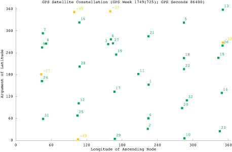
This data is very useful for GDOP (Geometric Dilution of Precision) statistics, which are quite surprising – and come about because of the 30+ GPS satellites in view and the resulting excellent geometry available.
The public data clearly shows that the GPS system is every bit as accurate, and indeed comparatively nominally much more accurate, than BeiDou, and GPS covers the entire globe, not just an area over China and portions of Australia.
It All Starts Here — GPS SIS URE
The GPS accuracy equation begins with the signal in space (SIS). Since 1978, the SIS figures for GPS satellites have continuously improved, as I said primarily due to more accurate orbit determination and more stable atomic reference systems, while the GPS URE numbers have continued to decline. Which is a good thing – smaller URE numbers are better.
Indeed, this clearly explains, in my opinion, why SVN49, which is a perfectly healthy GPS satellite, has never been set to healthy status. While the SVN49 GPS signals are all well within the published 6 meter URE – a never exceed threshold – they are significantly greater than 2 meters. Accuracy matters with GPS, so until corrections can be made, the satellite will remain in test status. Today, it serves as a very useful orbiting GPS test bed but does not enter into the SIS or URE equation.
GPS SIS URE is best explained as the pseudo-range inaccuracy due to ephemeris (orbit) and clock (atomic reference system) errors, which are common to all modern space PNT systems. The SIS root-mean-square (RMS) URE for GPS has been steadily declining over time (smaller numbers are better) and, consequently, so have the user range errors for users on the Earth. However, for my technical readers and space physics buffs, SIS errors are not determined by simple equations and therefore are sometimes difficult to describe accurately because they are neither purely stochastic nor deterministic. Indeed, Ph.D.-level subject matter experts such as Liang Heng, Grace Xingxin Gao, Todd Walter, Sherman Lo and Per Enge, from Stanford University, have clearly shown that SIS errors do not necessarily have a normal distribution Also, the traditional statistics such as sample mean and sample standard deviation may be affected by extreme excursions or outliers. However, these deviations do not significantly affect URE for most users, as they are effectively smoothed by long-term trend analyses and an active Kalman filter.
Better Clocks
Certainly, better atomic reference systems with frequency stabilities on the order of 1×10-E13 or better are partially responsible for these improvements, since one nanometer of clock stability typically equals one foot of position accuracy on the Earth’s surface. That number is important because I clearly remember the day in 1990 at the 1CACS (1st Command and Control Squadron) in Cheyenne Mountain (the 1 CACS is now located at Vandenberg AFB in California), when it was explained that the nominal ephemeris tracking error via optical systems for GPS satellites was on the order of two kilometers. The 1 CACS was responsible for providing collision-avoidance support during NASA shuttle missions and is still responsible for maintaining an extensive space satellite and space object catalog. Today, that error, using different tracking methods — including a global network of dual-frequency GPS tracking and monitoring sites — for GPS SVs approaches two centimeters or better. Consequently, better (more stable) clocks and more precise orbit determinations have greatly reduced the signal-in-space errors and significantly improved the position accuracy for all GPS users on a global scale. And for me that is the crux of the issue for GPS versus any other space-borne PNT system in existence today, or for any system in the near future.
A Global System
GPS is and has always been a global system, since its inception (1973) 41 years ago this year and since President Reagan decreed on September 16, 1983, just 15 days after Korean Air Flight 007 was tragically shot down by fighter aircraft from the Soviet Union (there were four other similar tragedies involving the Soviet Union on record) for being off course, that the Global Positioning System would be a gift from the United States to the world for precise navigation, so that this type of disaster need never happen again. Since that time GPS has been a truly global system for all users, friend or foe, without distinction. Of course longevity and dependability are merely two of the important factors that makes GPS the PNT Gold Standard.
GPS Stands Alone
I do not intend nor do I need to defend GPS as the global Gold Standard for PNT, the figures speak for themselves, however I do feel that the words Gold Standard, as I and many other subject matter experts, interpret them, may need a bit of an explanation.
One of my professional colleagues and a dear friend, for more years than I care to count, and I have long disagreed on this terminology. He feels the term Gold Standard is easily misinterpreted and should not be applied to GPS simply because it is not always well understood; instead he prefers the term system of first choice. However, that just does not have the same ring or historical significance as the Gold Standard.
What is a Gold Standard?
Leaving aside the monetary or financial implications for our PNT purposes, a Gold Standard is defined as the best one or the very best example of its kind — with synonyms such as: a system benchmark, a yardstick, a touchstone, the criterion, a paradigm and the epitome. Add to these descriptors the sense of longevity, endurance, dependability, and quality the GPS engenders among users — and you may be approaching the true sense of the phrase “Global PNT Gold Standard.” I can say unequivocally that the GPS is the only space-based PNT system in existence today that meets all these exacting and more fluid definitions simultaneously.
Historical Perspective
The Global Positioning System has had a continuous on-orbit presence since the second NRL Test and Development satellite was launched in 1977. GPS achieved IOC or Initial Operating Capability with 24 SVs (satellite vehicles) on December 8, 1993 (2SOPS celebrated the 20th anniversary of GPS IOC in December 2013). GPS FOC or Full Operational Capability was achieved on April 27, 1995, just 16 months later. Since that date, the GPS has never been less than fully operational, providing both the military Precise Positioning Service (PPS) and the civil Standard Positioning Service (SPS) to global users. As the staff writers at GPS Daily stated in a recent anniversary article:
Amazingly, though many Navstar satellites have been launched and been decommissioned over the past 20 years, four of the original Block IIA satellites which made up the IOC constellation (SVN-23,SVN-26, SVN-34, and SVN-39) are still operating and providing reliable PNT services as of this 20th Anniversary of IOC.
GPS has grown to become a vital worldwide utility serving billions of users around the globe. GPS multi-use PNT services are integral to the United States global security, economy, and transportation safety, and are a critical part of our national infrastructure. GPS contributes vital capabilities to our nation’s military operations, emergency response, agriculture, aviation, maritime, roads and highways, surveying and mapping, and telecommunications industries, as well as recreational activities.
It is not an overstatement to say GPS is fundamental to today’s technical infrastructure and culture. GPS provides the ‘winning edge’ to our warfighters and allies by delivering premier space-based PNT services to the nation and the world.
This indeed supports the definition, as I see it, of a Gold Standard for global PNT. A system that is long-lived, dependable, and just keeps improving every day. A ubiquitous utility that has changed the world we live in and the way we live our lives for the better, a system that now defines not only the critical national infrastructure of the United States but of many nations around the globe.
As for GLONASS, Galileo and BeiDou, we can have this discussion again in 20 years or so when they have been IOC and FOC for a credible period of time and have proven their accuracy, longevity and utility. For now, there is only one Gold Standard and that is the Global Positioning System.
What Is Don Reading?
This month, my reading preferences centered around mythical and real life figures in the CIA or Central Intelligence Agency. And frankly, sometimes it was hard to tell the difference.
screenshot: “Command Authority”
Command Authority, by Tom Clancy with Mark Greaney Putnam and Sons, ISBN: 978-0-399-16047-9
I devoured this 740-page tome in one weekend and was looking for more when I finally finished. This is one of those books you don’t want to end. It describes the life of the young Jack Ryan as a CIA operative during the Cold War, and of his son, Jack Jr., today. The authors manage the timeline to and fro adroitly so that it is never an issue. As usual, the action spans the globe and as far as I can determine the historical facts are accurate and the scenarios are riveting but believable.
Tom Clancy passed way just about two months before this final book was published. He managed to write 28 books in 30 years, a prodigious feat considering most of them were on the order of 700 pages or more (Threat Vector runs 840 pages). But to my mind, they were all too short, and Tom managed to exit, as any writer would desire, leaving his avid readers yearning for more.
Until next time, happy navigating, and think about what a difference GPS, the PNT Gold Standard, has made in your life. You might be surprised. And then grab a good Tom Clancy book. You have 28 excellent volumes from which to choose.
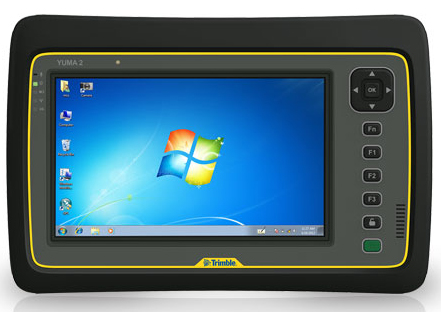
My original review of the first Yuma rugged tablet from Trimble MCS (Mobile Computing Solutions) was penned in August of 2011. My original plan was to have the review of the new Yuma 2 ready to go exactly two years later. But, as we all know, man plans and God laughs.
Actually, the problem, I must admit, is a bit more personal in nature; you see, I have been enjoying the Yuma 2 to such a degree that it was difficult to write about it because then I have to send it back. I have been selfish too long — read on for the review of the new Trimble Yuma 2 rugged tablet computer that is perfect for fieldwork, especially fieldwork involving GPS and GIS applications. Indeed, one Trimble marketing quote states:
“Bring Your Office to the Field for Efficient GPS/ GIS Data Management — The Trimble Yuma 2 rugged tablet computer is designed for ease of use and high performance mobility. Great for GIS applications — it’s like bringing a complete PC out into the field.”
While I totally agree with this assessment, the Yuma 2 is really so much more. It is not limited in any important function I could determine. As an example, I am typing part of this review on the Yuma 2 via a wireless Bluetooth keyboard and a high-definition Sony monitor hooked to the Yuma 2 via the new HDMI connector. Sweet!
Over the years, it has frequently occurred to me that oftentimes manufacturers have no idea of all the ways their equipment will be utilized in the field — although Trimble does a great job giving users ideas through the Trimble Dimensions showcase that will take place at the Mirage Hotel in Las Vegas November 3-5, 2014. If you are into rugged devices, GIS and GPS, or any of the areas listed at the Trimble Dimensions website, don’t miss this show. You will see the Yuma 2 and other Trimble devices and software put to the test and used in ways you could never imagine.
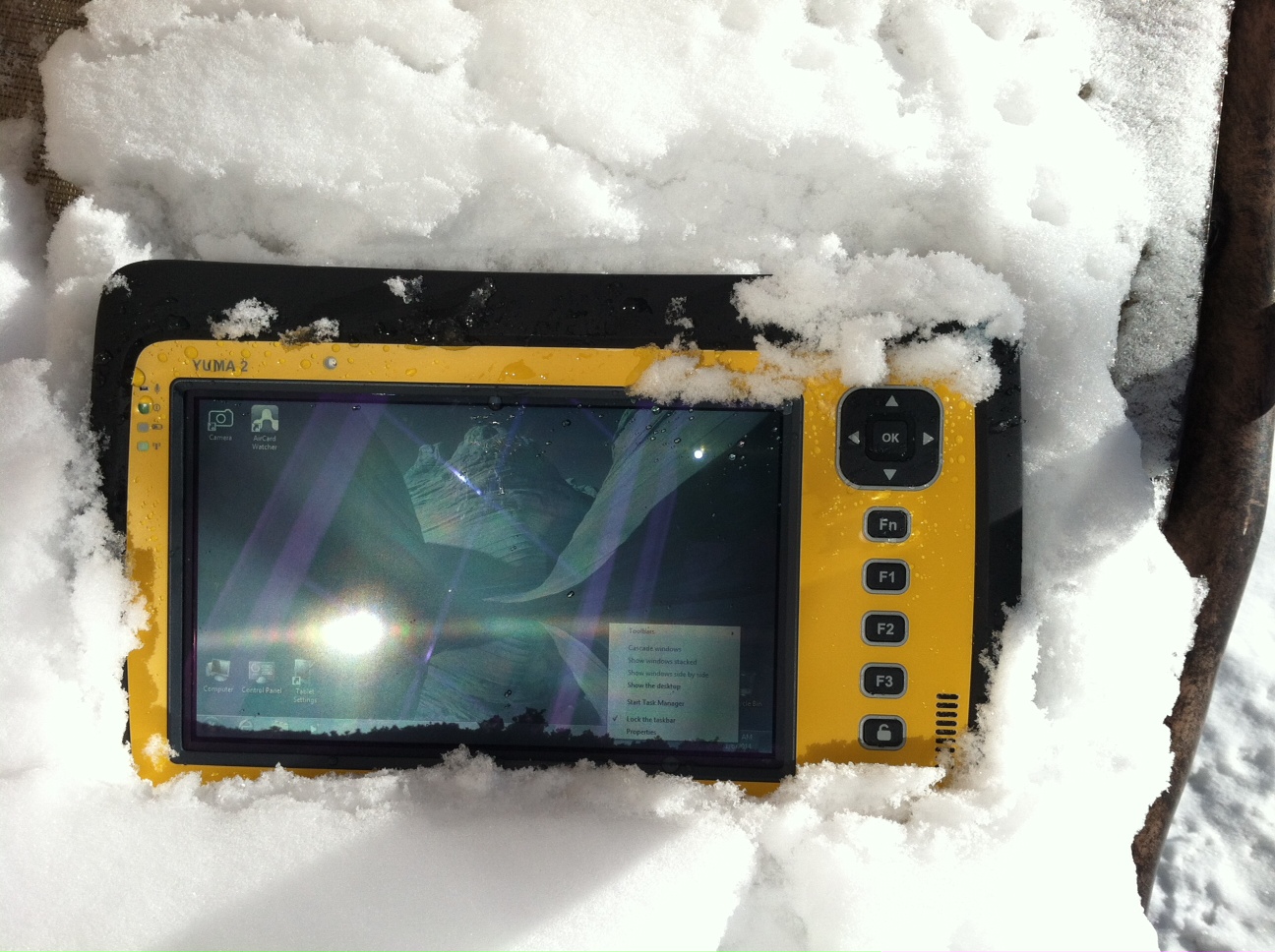
But, as usual, I digress. Let’s get back on topic and the Yuma 2 review. I put the Yuma 2 through all the normal wear-and-tear scenarios, which here in the foothills of the Rocky Mountains means severe cold (-20° F true temperature), snow, ice and altitude.
The Yuma 2 withstands tough conditions, including snow and ice.
During the six months I tested and evaluated the Yuma 2, I continued to receive several emails from users of the original Yuma rugged tablet. Three of those emails came from users in the Great Smoky Mountains. All three users operate the original Yuma in their business dealings, as well as for navigating around the Great Smoky Mountains and for recreational geocaching. One user, who would only agree to be identified as “Bailey” (he assured me that although he is retired military, his first name is not Beetle), intrigued me with his assertion that he has a crucial usability test he routinely performs on his GPS devices that I cannot easily conduct here in the Rocky Mountains. Beetle and other members of the Great Smoky Mountain Geocaching Society usually perform their Great Smoky Mountain Humidity and Fog tests at or around Clingmans Dome.
Clingmans Dome in the Great Smoky Mountains.
The National Park Service describes the 6,643-foot Clingmans Dome as being the highest point in Great Smoky Mountains National Park. It is the highest point in Tennessee, and the third highest mountain east of the Mississippi. Only Mt. Mitchell (6,684 feet) and Mt. Craig (6,647 feet) — both located in Mt. Mitchell State Park in western North Carolina — rise higher. Additionally, the cool, wet conditions at the summit of Clingmans Dome make the spruce-fir forest that grows there a coniferous rainforest. By now, you are probably saying, so what?
The “so what” is that Bailey says the humidity is sometimes so high that when geocachers hit the cooler temperatures and high humidity of Clingmans Dome, some devices have water streaming from inside the device, which is never a good thing. I checked with Trimble, and indeed their devices are made to survive these conditions and much worse, such as in many mountain jungles around the world. So Bailey, have no fear, your Yuma 2 will continue to work just fine in your moist environment. Consider that the Yuma 2 was designed and built at Trimble’s MCS facility in Corvallis, Oregon, which is just due East of a rainforest along Highway 1 on the Oregon West Coast. So you can bet the Yuma 2 is tested and rated for high humidity levels. Indeed, here are the humidity specifications: Cycles between -22° F to 144° F (-30° C to +60° C) at 90% RH (relative humidity), MIL-STD-810G, Method 507.5, Procedure II (Humidity Aggravated Cycle).
While we are detailing specs, let’s list all the formal specifications, and then we can delve into more detail about how we tested the Yuma 2 and how well it performed.
Physical
Size: (LxWxH) 9.6 in x 6.3 in x 1.5 in (246 mm x 160 mm x 40 mm)
Weight: 2.6 lb (1.2 kg) with standard batteries or 3.0 lb (1.4 kg) with extended batteries
Colors: Yellow, Gray, and Gray with Yellow border
Keys: Seven keys (OK, Logon, Power, Function, 3 user-programmable function keys) and 5-way directional keypad
Hardware Specifications
Processor: 1.6 GHz Intel Atom N2600 dual-core processor
Memory: 4 GB DDR3 DRAM of volatile memory
Storage: 64 GB or 128 GB SSD-Solid State Drive (Enhanced GPS: 128 GB SSD only)
Display: 7” 1024 x 600 hybrid reflective transmissive (transflective) with capacitive touch screen
Battery Options: Smart batteries with LED power indicators – Standard battery: Two 7.5v, 3000 mAh, 21.6 Wh or optional extended battery: Two 7.5v, 6000 mAh, 43.2 Wh
I/O: 3.5 mm audio jack, USB Host (2), HDMI, docking station I/O plate, DC input power
GPS Receiver: 1-2 meter accuracy (with SBAS) or 2-4 meter accuracy (with SBAS)
Radios: Bluetooth 4.0; Wi-Fi b/g/n
WWAN: Penta-band GSM 3.75 Data only module
Standard Features
• Transflective technology (TFT) direct sunlight readable color display
• Microsoft Windows 7 Professional OS
• Intel Atom N2600 dual-core 1.6 GHz processor
• 4 GB DDR3 DRAM volatile memory
• 64 or 128 GB solid-state drive
• Multi-touch capacitive touchscreen
• Rugged design certified to IP65 and MIL-STD-810G
• 3.5 mm audio jack and integrated microphone and speaker
• Outward facing autofocus 5 MP camera with LED Flash, photo and video recording capable
• Integrated Bluetooth 4.0
• Integrated Wi-Fi b/g/n and Wi-Fi Alliance Certified
• CCX (Version 4)
• GPS receiver, Enhanced 1-2 meter accuracy or 2 – 4 meter accuracy with SBAS
• Kensington security slot
• Accelerometer and Electronic Compass
• 3.75 G WWAN data connectivity optional
• Status LEDs for power, battery charging, Wi-Fi and 3G Data
• 12-month manufacturer warranty
Standard Software
• Microsoft Windows 7 Professional with Internet Explorer
• Camera software with geo-tagging
• Trimble GPS Information receiver control software
Standard Accessories
• Standard battery set (5+ hour)
• International AC Charging Kit with 4 adapters
• Capacitive Stylus with Tether
• Hand Strap and Display Cleaning Microfiber Cloth
Now that you have all the specifications and promises from Trimble, let’s look at how it compares to the original Yuma and then let’s get into how it works in everyday life as well as the not-so-routine scenarios.
Comparative Summary of Yuma and Yuma 2 Attribute
Yuma
Yuma 2
Touchscreen
Resistive dual touch
Capacitive multi-touch
Display Technology Sunlight Readability
Very Good
Excellent
Processor
1.6 GHz single core
1.6 GHz dual core
RAM
1 GB
4 GB
Solid State Drive
32 GB then 80 GB
Choice of 64 GB or 128 GB
GPS Accuracy
4 – 6 meter
2 – 4 meter
Battery Life3
4 hours with standard batteries8 hours with extended batteries
8 hours with standard batteries16 hours with extended batteries
Digital Connectivity
ExpressCard Modules
3.75G dual-mode (CDMA and GSM) option with SIM Card and Auto Carrier Recognition.
IP Rating
IP67
IP65
Pricing
$3999 Market Price for base configuration
$2999 Market Price for base configuration
First Impressions
The first thing most people notice about the Yuma 2 is its size. It is 1.5 inches shorter than a full-size iPad, while the high-definition screen is the same size and almost the same resolution as the iPad mini. With the ingenuous hand-strap attached to the back, the Yuma 2 is very maneuverable and easy to carry with you in most any situation. With the security cable, you can also attach it to a vest, backpack or even a belt loop for security. I tried all three options and it works well. For warfighters and first responders, this is ideal, as those users don’t need to worry about what happens if they should drop it. The Yuma 2 is IP65 MilSpec rugged, and I am frankly amazed at the punishment my demo unit survived. Just like the old Timex commercial — “It takes a licking and keeps on ticking.”
Attention Getter
I carried the Yuma 2 everywhere for more than six months, and it garnered a great deal of attention from military and medical personnel of all descriptions: policemen, firefighters, delivery drivers, utility workers, and several park rangers. Even our local refuse haulers spent time looking over the Yuma 2. It is just simply hard to ignore. Interestingly, something they all had in common is that initially they were all very dubious and nervous about dropping it, even on thick carpet, grass, ice or snow. But once they saw me do it, they all wanted to have a go and they did. My demo unit has easily been dropped more than 100 times from various heights, usually from about four feet onto almost any surface you can name, and it continues to perform like the pro-gear it is and was designed to be. It was even dropped twice, unintentionally of course, with the camera in video mode and the LED flash active. I have to admit that initially gave me pause, but the Yuma 2 came through without a hitch. Camera, video and flash all still function perfectly.
Field Capability and New Test
With the Yuma 2, I had an opportunity to test an application I have never run before, but which will now be a standard in my repertoire of applications — the functionality of an audio headset along with Dragon Speaking software.
Long story short, my daughter is a PsyD, or Doctor of Psychology, in private practice, and together we have been testing various software programs that convert her spoken notes into the written word. This is a more difficult task than you might imagine, given all the specialized medical and psychological terms employed in her everyday vocabulary. But the latest professional version of Dragon Speaking was absolutely up to the task, as was the Yuma 2. I installed the Dragon software and went through the brief training routine with the headset and microphone, and the result is the paragraph you are reading. What a great way to write an article.
Now my daughter and I are Apple aficionados. We have more than 21 Apple devices in our homes, and my daughter uses a 13-inch Apple MacBook Pro with a retina display in the office, which, while it is an awesome device, is not something you want to take into the field or into a first-responder situation, whereas the Yuma 2 fulfills the same functions and fits the “rugged” bill perfectly.
While the built-in speaker on the Yuma 2 is certainly adequate for voice recognition and for GPS commands, it is not something with which you will want to listen to iTunes, so I highly recommend the optional audio headset with microphone offered by Trimble and several other suppliers. For me, the new Bose headset model with microphone works extremely well, while remaining affordable, and the resulting fidelity is…well…certainly Bose quality — what more can I say!?f you want audiophile-quality music and speech-to-text transcription capability in the field, then the Bose headset and Yuma 2 combination can’t be beat.
Docking Station and HP ePrint
The unit we tested did not arrive with the optional docking station. However, we quickly determined that if you are going to be constantly, even daily, making the transition from field to office computer and want to work on the same computer, then a docking station is a must. Next time, say for the Yuma 3 review, for instance, we will request a docking station as part of the review hardware. There were so many times we wanted to print directly from the Yuma 2 that I wished fervently for a docking station. Then I found that the HP ePrint software worked just great on the Yuma 2 as long as you are in range of a printer capable of receiving the signal.
If you are on the road and need to print, you can do that via the cloud and ePrint no matter where you are. You can also print your documents to the nearest HP Public Print Locations, which include national chain locations for FedEx Office stores, UPS stores, Walgreens, numerous hotels, airport lounges, and more. Prices vary widely per page, but if you really need a hard copy, this is an amazing option that works well with the Yuma 2.
We tested this print option at our local Walgreens, and they were not initially aware they had the capability until we printed a test page and out it popped. Now they advertise the capability. We also tried printing from the parking lot of a local FedEx store, and since I have a FedEx account (we receive a lot of packages, as you can imagine), the page was waiting for us when we walked in the door and the bill was automatically charged to our FedEx account. It was an incredibly quick and painless process.
Camera and Flash
The 5 MP (megapixel) camera with automatic geotagging and LED flash work as advertised, although with the Yuma 2 we were also able to record a short video that played back flawlessly on the Yuma 2 and via the email attachment on my Apple iMac. The only caution here is that you are definitely capable of recording a video that, due to its size, may never work its way through the normal email system. Fortunately, the GPS World magazine servers and my “other office” servers are “unlimited,” so this was not a problem for us. However, when we attempted to send a 20-MB video file to a friend, his system would not initially authorize it. When we compressed the file, it went without a hitch. So, if you are going to be shooting a lot of video in the field, a good video software compression program is highly recommended. We tried no less than five different free video compression algorithms, and they all worked without a glitch. Note: Some programs, but not all, require the same software be resident on the receiving computer as well.
Power and Data Connectors
Fortunately, the power connector on the Yuma 2 device is heavy duty. It is reminiscent of the old serial port (RS232C) connectors with the screw receptacles on the port. Consequently, you will never have to worry about the power cables being disconnected, at least not on the Yuma 2 side. There is also an USB-RS232C dongle available that comes in handy for data logging from external sensors.
GPS Applications and Accuracy
While Trimble MSC is not publishing much about the GPS specifics, from a technical point of view in the Yuma 2, Trimbe is shouting from the rooftops that you can have nominal 2-4 meter accuracy or enhanced 1-2 meter accuracy (both with SBAS or Space Based Augmentation System – in the U.S., think WAAS or Wide Area Augmentation System) depending on your requirements. There is an option for an external GPS antenna, and while the three different RTK programs we ran on the Yuma 2 produced excellent and consistent sub-meter accuracies, RTK programs can be expensive. So with the Yuma 2 you should be capable of deriving accuracies anywhere from 4 meters to 4 cm, depending on your timing requirements, how much you want to spend, and sometimes your altitude.
Altitude
Which reminds me: I really got a kick out of the correspondence from the three geocaching Trimble Yuma users in the Great Smoky Mountains, mentioned at the beginning of this column, because all three made such a big fuss about the 6,000+ feet of altitude they routinely encounter when geocaching. My initial reaction to that concern is akin to that of the old codger mountain man in the great movie Continental Divide with John Belushi and Blair Brown in 1981.
John’s city-bred character mentions that being a smoker the high altitude in the Rocky Mountains is beginning to bother him, at which point the heretofore reticent old mountain man indignantly replies, “Mountains? These here are foothills, just bumps in the ground, these ain’t mountains!” Therefore, since my home sits at an altitude 1,000 feet or more higher than any of the Great Smoky Mountain peaks, and I can be at 14,000+ feet within a 20-minute drive and cross the Continental Divide in under an hour’s driving time, I understand the old mountain man’s consternation and directly relate it to the users’ concerns about the Great Smoky Mountains, which when compared to the Rocky Mountains in Colorado, are indeed bumps in the ground. I mention this only because at 7,500 feet with no obstructions, the Yuma 2 routinely processes 8-12 GPS satellites and reports accuracies far superior to those publicized by Trimble. So, while you should not necessarily expect the same level of accuracy I have reported here, you should probably expect accuracies in between what Trimble publicizes and the sub-meter performance we observe on a regular basis.
Software
I have frankly lost count of the multiple GIS and GPS software programs I ran on the Yuma 2, but they all basically ran flawlessly, both the free apps and the more costly programs. The only issue I encountered is that some GPS programs require utilizing different ports and transmission speeds. However, since these parameters are user definable on the Yuma 2, it never presented any serious obstacles. Caveat emptor, for here I will remind users of the old axiom, “You get what you pay for!” The free GPS and GIS apps work fine, but the amount of metadata and accuracy provided by some of the more costly applications is nothing short of amazing. If you plan to use the Yuma 2 for scientific applications and desire onboard processing, then the more costly software programs are the applications I would recommend. If the Yuma 2 is just a data logger or positioning device, then the free applications work well.
Bottom Line
The Yuma 2 is an amazing machine. It is everything a high-end laptop should be and more in a ruggedized format with a Gorilla Glass high-definition display touchscreen that should be reassuring to users in the field.
For government users, the rugged Yuma 2 tablet with a Selective Availability Anti-Spoofing Module or SAASM option would be the perfect choice, and far superior to anything else in the field today, especially for our military. My sources tell me there are thousands of Yuma and Yuma 2 tablets in the field today, and the addition of a SAASM module would make them more secure and usable by our military users for all their tasks. Imagine one secure tablet that meets all your needs. I think our warfighters deserve the best, don’t you?
If you currently accomplish fieldwork and transfer data between two computers, and make use of GIS and GPS data, then the Yuma 2 is the machine of choice for you because it will do the work of both computers and display/output data through the HDMI interface or through the wireless ePrint capability, especially if you opt for the optional docking station. The SSD (solid state drives) are super fast, and since there are no moving parts on the Yuma 2, you may well find it is faster and more dependable than your current office laptop or even desktop computer. I highly recommend it.
Until next time, happy navigating and take a rugged computer out for a spin.
Remembering a Time before GPS — and a Lifelong Friend
One of my oldest and best friends died today – and he was just a kid, only 62. In the prime of his life, and yet I know he led a very full life and had no regrets when he passed on to that highway in the sky — somewhere where he will hopefully not have to ask directions, because neither one of us was very good at that. Indeed, in our youth, both Gordy and I were GPS-challenged long before GPS was a gleam in Dr. Parkinson’s eye.
I first came across Gordon F. Oates, Jr., and his future wife Valerie at a private media party more than 40 years ago. Gordon was the nephew of Warren Oates, the famous actor — who was a regular on the Gunsmoke and Rawhide westerns in the late 1950s — black and white television ring a bell? Warren Oates was certainly known to have a wild streak in him. As I grew to know Gordy, I always suspected he inherited a bit of Warren’s independent DNA. But I digress — Gordon and I teamed up one summer while I was attending the University of Kentucky, both as a student and as the managing editor of the Kentucky Wildcat newspaper, and Gordon was attending the University of Louisville, also in Kentucky. Our common theme when we met was we were both working for the Courier Journal newspaper at the time. Not that we were well-known columnists or writers — no, we were just two young men of the South from two of Kentucky’s finest universities trying to make a few extra bucks during the summer break. Over the two summers of 1970-71, I think we visited every city, tiny berg, holler, village, and wide spot in the road that existed in eastern Kentucky.
After the Courier Journal paired Gordon and I as a team, assigned us to cover eastern Kentucky, they then notified us we would need to provide our own transportation. I had a 1965 Fiat Spyder that I had brought home after attending college in Europe a few years before, which would barely fit my six-foot-one frame and a suitcase. Gordy, although two years my junior, was a few inches taller, loved basketball, and outweighed me by fifty pounds, so the Fiat was not an option for the both of us. But Gordon’s mode of transportation — Wow! Gordy had a brand-new 1970 bright red 320 Boss Mustang with a huge spoiler. The specs state the original Boss Mustang capable of accelerating from 0-60 mph in 6.9 seconds. The quarter mile took 14.6 seconds at 98 mph and we routinely and brazenly tested those specifications in the mountains of Appalachia — fog, rain, snow, coal trucks, slow-moving farm tractors, blind curves, thousand-foot sheer drops and all. The Dukes of Hazard had nothing on us “City Slickers” (more on that appellation shortly) from the Courier Journal. We visited Hazard and Walker Town, Kentucky, several times those two summers, and although we never met Daisy Mae, we met a young lady whose story changed both our lives.
Lost? Never. Bewildered? Maybe.
When I say we visited several places several times, our repeat visits were not always planned or even generally on purpose. You see, Gordon always drove the Mustang, and while he loved that car and he loved to drive, he was also always a happy soul and not overly concerned with directions. Even when I gave him directions, he could not always hear me because we listened to whatever country station he wanted — driver’s prerogative, of course, and there were few choices — for sure Loretta Lynn and Dolly Parton were on every station singing as loud as the volume knob in that Mustang would take them. Plus, as the driver in charge, it was also Gordy’s privilege not to ask directions. That’s right, it’s a guy thing, and yes, I said not to ask directions. Many of my masculine readers will be familiar with the concept. After all, how could two college boys from the big city of Louisville, the biggest city then and still today in the Commonwealth of Kentucky, ever admit to being lost in the mountains of Appalachia? And how could we ever stoop so low as to ask directions, especially since every single time, rain or shine, we stopped for gas, which was frequently at those speeds, a huge crowd gathered to gawk at that bright red Boss Mustang? Now, just how could we lower ourselves to admit we were lost? Horrors! I can hear the snickers now — big city slickers are lost! So Gordy drove like a bat out of the proverbial nether regions and I attempted to read the map. Ever try to read a Texaco map while careening around curves in the mountains of Appalachia, while avoiding coal trucks and trying to keep your lunch down? Losing your lunch in the Mustang was not an option, just as it was not such a good idea to look down at the rusted hulks of automobiles strewn along the mountainside or at the river gorge so far below you could barely make out the water.
I did not have an inkling then that anything like GPS (Global Positioning System) would be commonplace just 20 years later, but it would have been merely one of the many things I would have been praying for had I known. So we made do with Gordon’s Positioning System — which invariably failed, except for the day it took us to a tiny mountain village in far eastern Kentucky.
Pikeville
We rarely spent more than 30 minutes in one of the tiny hamlets or hollers in Kentucky’s eastern mountains, better known to the world as Appalachia. But I know Gordon never forgot and I will never forget the cold and rainy late fall day we stopped in Pikeville, pronounced proudly by the young lady in the café that day as “PYKE-vull” as in “Howdy gents, water you two city slickers adoin’ in Pikeville?”
We were there merely to have lunch at the only café in the entire village. It featured six tables with mismatched cane-bottom chairs, sawdust on an aromatic, weathered and stained (with what, I did not want to know) pine floor with knotholes every few feet, and a menu that seemingly the locals and our waitress knew by rote, since we never saw one. We, of course, according to our very young waitress, would have the Blue Plate Special, consisting of “burgers, fried ’taters with catch-up, cola and pie.” She “allowed” as we could have a fried egg or gravy on our burger for an extra five cents. I think we both passed.
It was actually the life story our waitress haltingly related that caught and held our attention that day. She said she was 14 years old — our best guess was twelve. She wore a flour-sack dress that could only be described as threadbare — but if you looked carefully, you could still read “50# lbs of bread flour by weight” right on the back of her dress. She wore no socks or shoes, and this was in late November, just the week, according to her, afore Thanksgiving in 1970. Come on back next week, she said, and we could have turkey with all the trimmin’s. Which we hoped meant more than a fried egg and gravy.
Although she spoke with a strong Kentucky burr, she obviously knew the limited menu by heart, as we never saw her write down an order. When she spoke to the cook in the kitchen, her strong accent made her almost indecipherable, even to two Kentucky boys. And, without a doubt, she was clearly the one who gave us the handle “Big City Slickers” and informed us that she “hain’t never read no ‘pepper’ from the big city.” We talked while we were waiting for our food, as everyone else in the café was, as she exclaimed, “out pawin’ and fawin’, over the big red car in the rain with’n the horse on it, parked right in front.” That is, except for an old gentlemen sitting in the corner by the roaring fireplace, who was chewing and spittin’ tobacco. Obviously a favorite appetizer for folks in Pikeville. But I digress — our obviously underage waitress wanted to talk, and she told us about her life back in the holler, living in a log cabin/tarpaper shack over a hog pen. Her daddy was a part-time coal miner and moonshiner, who could get us some shine (moonshine) iffin we wanted it — the cops didn’t make no never mind, she said. She reckoned she was one of eleven children from her Momma, who were livin’! She did not say how many of her brothers and sisters had passed on, but it was obvious the number was not small. She went to school when the truant officers caught her and made her go, but her family needed the five dollars a week plus tips she got from the cafe.
Consider that back in 1970 regular gasoline went for about 36 cents a gallon in Appalachia, cheaper than in Louisville I remember, and it took just about six dollars every time we filled the tank on the Mustang. And this young lady worked as a waitress at twelve years of age so she could make $5 a week plus tips for her family. Of course she said she also received her meals “free” and could occasionally take some food home “if’n she could carry it the five miles yonder to the holler.”
Please don’t get the wrong impression; neither Gordon or I ever made fun of this young lady, of Pikeville, Kentucky, or of Appalachia. We had just never encountered anyone like her or her circumstances previously. After all, we were “big city slickers,” university men, newspapermen, and this young lady was proud of her story — there was not a single “woe is me attitude” on her behalf ever in the short time we knew her. Quite the opposite: she was obviously responsible, and very proud to have her job. She was forthrightly proud of her Momma and her family, and as she said, she respected her Daddy. She was getting a new dress for Christmas, but her only lament was that she had never owned a pair of shoes. But then she said, “It is hard to miss something you never had.
Prior to visiting this particular café in Pikeville, Gordon and I never ate more than one meal in any one restaurant or café for the entire two summers. Moving from town to town several times a day was the name of the game in the newspaper business. However, somehow Gordon kept “getting lost,” and we ate nearly every meal at the same café in Pikeville for three days straight, until it was just too far to “get lost to” anymore. Our meal receipts were always about a dollar, and yet I know we both quietly left five one-dollar bills underneath our plate every time we ate there. Years later we both commented on the fact that it was snowing the week after Thanksgiving, which was the last time we were in Pikeville and in that little café. Our waitress still had no shoes, but she proudly showed us her new wool socks.
Gordon and I have since discussed that we could not find that little café or that waitress in Pikeville ever again with or without a GPS, because hopefully they no longer exist, at least not under the same circumstances. Pikeville is certainly still there, and has grown from a population of less than 5,000 souls in 1970 to just about 7,000 inhabitants today. Our little waitress would be 56 years old today, if she is still living, and believe me, living in Appalachia in a tarpaper shack, longevity is not a given. But her memory still lives in our hearts, along with the highways and byways of Appalachia, and who knows, Gordy may be speaking with her today, because every time we left that little Café she would sing out, not just a wholehearted thank you for the tip, but a loud and obviously heartfelt “God bless y’all! Come back, ya hear!”
Until next time, happy holidays, happy navigating and pick up the phone and call an old friend today — you just never know. Hope to see you right here next year.
A couple of years ago, wearing a different hat, I found myself on a guided tour of a key military C2 (Command and Control center) that was about as big as a football field and was to be deployed somewhere in Southwest Asia. My colleagues and I, who are all GPS SMEs (Global Positioning System Subject Matter Experts), asked the same question of almost everyone we saw that day. Near the end of the day and the tour, we had yet to receive an adequate answer. The typical response was, “Please save that question for our senior communications officer.”
Finally, at the end of the tour and demonstration, we met the communications chief, and we once again asked our persistent and, for some of us paramount, question: “What would happen if we walked into this facility in the middle of a major military operation and activated a Coke-can-size GPS jammer that we were surreptitiously carrying in a backpack? In other words, what would happen if we disrupted your GPS signal reception?”
The communications expert thought awhile and then answered. Unfortunately, the answer was a bit perplexing and yet all too common, inside the military and out. The communications officer hesitantly replied, “Well, this is a C2 center, and we are all about computers, networks and communications, and although I have to admit I don’t know much about GPS, other than we use it to navigate our military and civilian vehicles, I guess I would have to say it would not make any difference. In fact I am not even sure we would notice.”
Quick as lightning, before I even had a chance to challenge the response or thought process, a grizzled old E9, who proved his operational savvy that day, interjected, “Beg your pardon, but all of our radios, computers, networks and communications gear are referenced and synchronized to GPS time. A GPS jammer would take us out of business until we brought up our backup atomic reference system. So, initially a Coke-can jammer activated in our facility would be catastrophic, but we would soon be back in business because we have backup atomic reference systems.”
Fast-forward, and today that transition between GPS and atomic reference system is seamless. There is no down time, and yet the systems still run on GPS time. But during that initial visit, I could tell by the looks on the junior communications officers faces that surrounded us that, while they appreciated the save by the old chief, they were also still wondering, just how pervasive is the actual impact of GPS time for computers, networks and communications?
The answer is simple. The world as we know it today runs on GPS time.
GPS — Time and Frequency
This is unfortunately a scenario my colleagues and I encounter all too often. While it is not my intention to launch into GPS 101, it bears repeating that of the approximately 3.5-billion-plus users of GPS and PNT (Position, Navigation and Timing) systems in the world today, 90% use the signals for incredibly accurate time-keeping and frequency stability, not just for positioning and navigation.
Indeed, GPS SVs (space or satellite vehicles) today typically contain either three or four atomic reference systems (atomic clocks), primarily long-term, stable Rubidium systems with shorter term stable Cesium clocks as a Primary Reference Source, that continually broadcast Stratum-1 timing signals with stability on the order of 1×10-E13 or a pico second (a trillionth of a second) or greater.
For the mathematically challenged, that means the stability of the atomic clocks are such that if the GPS atomic reference system could be maintained in a perfect environment for the lifetime of the clock, nominally 20-30 years for Rubidium systems, it would never lose a second of time. To put this number in perspective, consider that the navigation revolution (easily the biggest change in navigation since the sextant was invented) brought about by Harrison’s chronometer, perfected in 1759, allowed accurate navigation by Longitude and Latitude, by keeping and transferring time aboard ships with accuracies in the 10-second range over periods of weeks. And even though at the time it was hailed as a chronometer, its lack of accuracy is such that most navigators today could not tolerate the inaccurate time or lack of stability, not when they can measure time to the trillionth of a second or better simply by receiving a free GPS timing and frequency signal available globally.
Interestingly, the clocks on the Boeing IIF GPS satellites (currently four SVs on orbit), which certainly have other issues, are proving to be the most stable Rubidium atomic reference systems ever flown in space to date, as they are currently displaying an unexpectedly high degree of frequency stability. Hopes are that future spaceborne atomic reference systems (such as in the GPS III LMCO SVs) may achieve two orders of magnitude greater stability at 1×10-E15. Compared to Harrison’s chronometer, that is an improvement on the order of 17 orders of magnitude!
Now, if you are still wondering what all this clock stability means to you, consider that one nanosecond, or merely one billionth of a second, equates to a foot of positioning accuracy on the Earth, but even more importantly, for 90% of GPS users globally, time and frequency stability equates to an incredible, dependable, stable, ubiquitous timing source for the initiation and synchronization of networks and communications systems worldwide.
When you consider that almost everything we do today involves timing, networks, computers and communications in some form, it also means that when we consider our (United States) Critical National Infrastructure (there are 16 critical infrastructure sectors defined today), all 16 depend in some form or function on GPS time and frequency stability. That is a sobering thought, and is exactly why we often use the words “ubiquitous” and “utility” when referring to the Global Positioning System. Make no mistake about it: almost every major country you can name today has the same dependency on time and frequency stability for their Critical National Infrastructures, and the majority use GPS as their primary timing, frequency and/or reference source.
Dependence
Some of you — and you don’t necessarily have to be a conspiracy theorist to think this way — will immediately see this dependence on one space constellation or system as a vulnerability. You would be correct, if there were no backup systems, augmentations or alternatives. Fortunately, just like the military C2 center, the majority of our Critical National Infrastructure sectors today have interim or temporary backups. While you should view that as a fortunate circumstance, it is also the limiting factor, or LIMFAC, in our infrastructure; the majority of the backups are terrestrial, oftentimes temporary in nature, and they rarely have the same degree of coverage, reliability or stability of GPS.
Many of you may still be saying to yourself, so what? Here’s the so what: without GPS timing and frequency stability, we as a nation may be able to generate electricity, but we would not be able to distribute it. We may be able to drill for oil and produce products such as gasoline and diesel, but we could not distribute them, and you would not be able to dispense or purchase them at the pump. You could earn money, but you would not be able to access your bank account or bank records online or at an ATM. All of these systems depend on computers, networks and communications, and they all depend on GPS time and frequency for synchronization. Get the point!?
Knee-Jerk Reactions
Unfortunately, this realization has led many of our senior leaders in the services and the federal government, who should know better, to make broad and blanket knee-jerk statements concerning the need to replace GPS that are entirely unwarranted. As I said earlier, if you think of GPS as a global utility, that is exactly what it is. Then you must treat it just like you would electricity, for example. Certainly much of the world runs on electricity, and as you have seen, much of the world also runs on or certainly depends on GPS timing and frequency signals.
However, as much as we depend on electricity, we don’t scream “find another energy source” every time the lights go out due to a storm, or power cables are cut by an accident or a farmer’s plow. Instead, prudence dictates that we plan for these occurrences, and we utilize other temporary or alternative methods of generating electricity such as backup generators. Indeed, we routinely use solar power, wind power, and batteries to hold us over until the main power is restored.
We should think of GPS in the same way. When the GPS signal is interrupted, we should not immediately call it unreliable. Rather, we should use atomic clocks, inertial systems, and other PNT systems until the gold standard GPS signals are once again available. The solution is all in how you parse the problem.
eLORAN
If there were only a persistent, wide-area, wireless solution to our problem. Fortunately, there is, and as a nation we are well acquainted with one answer and one solution, which in my opinion is the answer and a time-proven solution. For more than 70 years, since before WWII until 2010, we as a nation had the answer. The near-perfect backup and/or augmentation system for GPS was already in place; it was a coterminous system originally designated LORAN-A (long range navigation). The legacy system (LORAN-C) was in the process (90% complete) of being updated to eLORAN, a modern digital system, when inexplicably the current administration decided the entire project was a waste of money; it’s a well known government condition or disease better known as myopia or shortsightedness. Now that same administration is spending more money every year ($50M) to tear down the LORAN-C and existing e-LORAN infrastructure and remediating land at the 28 transmission sites. The annual cost of operating the e-LORAN system for one year ($16M) means these same funds could operate the eLORAN system for more than three years.
The sad part is that while our government is wasting taxpayer dollars in a severely constrained, sequestered budget environment, destroying badly needed LORAN-C and eLoran infrastructure, the rest of the world is busy building modern eLORAN systems (there are currently ~75 LORAN towers in the world today) as a backup and augmentation to GPS — countries such as Great Britain, Japan, South Korea, and Russia with their CHAYKA system, just to name a few.
A recent RNTF (Resilient Navigation and Timing Foundation) white paper (more on this new organization later) on GPS and LORAN points out that an independent think tank known as IDA (the Institute for Defense Analyses), an organization of which I am proud to be a member and which includes Dr. Bradford Parkinson, who many call the father of GPS, recently conducted a study on GPS and LORAN and recommended that, “an existing and outdated nationwide navigation system called ‘Loran-C’ be greatly updated and modernized to ‘eLoran’.’’ Such a system would provide a navigation and timing signal comparable with and complementary to GPS. The IDA study concluded that: “eLoran is the only cost-effective backup for national needs; it is completely interoperable with and independent of GPS, with different propagation and failure mechanisms, plus significantly superior robustness to radio frequency interference and jamming. It is a seamless backup, and its use will deter threats to U.S. national and economic security by disrupting (jamming) of GPS reception.”
The story of how the United States, which pioneered LORAN, wound up without an eLORAN system today, would be comical if it were not so sad. It is a long and sometimes incredulous tale, as Shakespeare once said, “full of sound and fury,” that I will not take the time to relate; however, I will say that it is not too late. Indeed, if we were to merely admit our mistakes and take the money budgeted for one year of LORAN-C and eLORAN destruction, we could not only build an entirely modern eLORAN system (for ~$40M) but we could operate it for the better part of a year while we figured out ways to make it pay for itself, and believe me when I say there are numerous viable courses of action that make this a real possibility. Then we, as a nation, would not only have a 4,000 KW terrestrial backup and augmentation to GPS, but we would have a backup and augmentation for timing and frequency stability for all of our Critical National Infrastructure sectors that would be nearly impossible to jam or spoof. Consequently, if you can’t jam or spoof the backup, then why bother trying to jam or spoof the primary system, GPS? In this instance, a modern e-LORAN system becomes a security blanket for GPS as well. It is indeed a win/win proposition.
NSPD-39 and RNTF
Lest you think I am a lone voice crying in the wilderness, in 2004 President Bush issued a National Space Policy (NSPD-39) that addressed the problem of GPS dependence. The space policy directed DOT and DHS (Departments of Transportation and Homeland Security) to find a suitable backup and augmentation for GPS. Six years later, a new administration unabashedly began destroying the only viable system that currently meets the parameters spelled out in NSPD-39. Fortunately, there are many today in and out of government that think as I do, and fortuitously they are doing something about it.
Several months ago, I wrote about Charles (Chuck) Schue and his new digital e-LORAN system at UrsaNav being tested and supported by a CRADA or Cooperative Research and Development Agreement with the U.S. Government, and I promise you an update on that endeavor soon.
Now there is an independent non-governmental foundation, the Resilient Navigation and Timing Foundation (RNTF), that supports a P3, or Private-Public-Partnership, to help develop and fund eLORAN as a private/public leased service to the government, and any other interested parties for that matter. In other words, the foundation proposes, among other ideas, to build and operate a modern digital eLORAN system for the United States, for all the reasons mentioned earlier, and lease that service to the U.S. government among others. Using P3 means that in this sequestered budget environment there are no upfront development or deployment costs to the government, and yet the system that augments and backs up GPS and critical timing for our Critical National Infrastructure is in place and operating as a private entity, employing people, paying taxes and providing a critical service. As I said, a winning proposition for all concerned.
If that were not enough, just this week the GAO came out with a report entitled GPS Disruptions: Efforts to Assess Risks to Critical Infrastructure and Coordinate Agency Actions Should Be Enhanced. You can find the highlights for the report at the following link: http://www.gao.gov/products/GAO-14-15. Once there, you can click on the PDF link for the report, which is about 58 pages. So, it is a hot topic, and one that can be easily solved once common sense again reigns in our government.
What Is Don Reading?
This month, I am going to recommend two edited books that are worlds apart in concept but are both highly related to the use of GPS, one theoretically and the other physically and fundamentally.
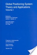
The Global Positioning System: Theory and Applications, by Parkinson and Spilker.
The Global Positioning System: Theory and Applications,
by Dr. Bradford Parkinson and Dr. James Spilker
1996, American Institute of Aeronautics and Astronautics
ISBN 978-1-56347-106-3
This exhaustive two-volume compendium of GPS knowledge is my daily bible for almost any GPS technical query you can muster. The two volumes total 781 pages and, truth be told, they are certainly doorstops, and while they are essential to your encyclopedic knowledge of GPS, they are certainly not to be carried around as textbooks. They are reference books, and the kind that should remain in your library at home. I treat my copies very gingerly, since they are about to fall apart from constant use. Plus, both volumes are signed by both editors, since they are both close friends and colleagues — but that is not why I recommend them. If Dr. Bradford Parkinson is the father of GPS, then Dr. James Spilker is the father of the GPS frequency and signal structure. Both Brad and Jim are currently Professors Emeritus at Stanford University and we visit on a regular basis, but again, friendship does not enter into my recommending these volumes.
I recommend them because they are simply the best compiled and edited volumes on GPS that exist today. They are authoritative and technical to a fault. As I said before, the word exhaustive comes to mind, and frankly, I don’t know how any GPS aficionado or SME could make it through the day without these incredible reference tools. I know from first-hand knowledge that both Brad and Jim have been approached about an updated edition, but I don’t know how they would find the time. They are both in great demand and are constantly writing and speaking about GPS in venues around the globe. But it would be wonderful if they could fit it in. Now a digital, searchable version — that would be something.
Guide to Super Snipers, Soldier of Fortune Magazine, edited by Brown and Spencer.
Guide to Super Snipers, Soldier of Fortune Magazine,
edited by Lt. Col. Robert K. Brown and Vann Spencer
2013, Skyhorse Publishing
ISBN 978-1-62636-067-9
This book is an edited history of snipers and their equipment that in the last 15 years has included GPS and other PNT systems on a consistent basis. Soldier of Fortune magazine and the editors interviewed literally hundreds of snipers around the world, and this is their story. Some of the snipers made headlines, like Audi Murphy, and were popular American heroes. Others you will have never heard of, but that does not make them any less meaningful or important in the roles they have played keeping their country safe.
This book includes great details about legacy and current sniper rifles and the expert marksmen behind the scopes and sights. It may be more than you ever wanted to know about the art and science of snipers, but it is an inspiring and patriotic book that many will thoroughly enjoy. Be aware there are numerous typographical and grammatical errors — try not to let that impair your enjoyment of this one-of-a-kind book.
Until next time, visit the RNTF site, support eLORAN, read a good book, and I wish you happy navigating.
Many may consider it a distinction without a difference, but quality matters, whether it concerns a life-changing decision or something as simple as which conference to attend. When resources are scarce, making the right decision, or sometimes just making any decision, matters — for many in our government this paradigm should reign supreme.
Over the past 24 months, it seems there have been more conferences and symposia that depend on government attendees cancelled or postponed than there have been quality events to attend. Politics aside, the U.S. government’s fiscal woes, which include sequestration and the latest partial U.S. government shutdown, are merely endemic of a much greater problem. Decision makers are unable to make decisions, negotiate or even consider compromise, and the last time I checked, decisions, indeed quality decisions, are critical to the success of any endeavor, be it government or business.
More than 2500 years ago, Pythagoras (yes the Pythagorean Theorem mathematician) said “Choices are the hinges of destiny,” and make no mistake about it, the decision to not make a decision or the inability to act is still in the end a decision, just not an action or non-action of which one should be proud. And this inability to make a decision still affects your destiny today or our destiny where Congress is concerned. William James may have been thinking about the U.S. Congress when he said, “When you have to make a choice and don’t make it, that in itself is a choice.” Actually, my secretary summed it up nicely, extolling her frustration with our do-nothing Congress, “…in the end if I conducted myself as your employee the way Congress has conducted their affairs for the last 24 months, I would no longer be in your employ. You would have fired me long ago.”
Fortunately, for the rest of the world, there are people who seem capable of making momentous decisions on a daily basis — imagine that. And despite what the entrenched U.S. Congress doesn’t decide, the world does go on, even as the somnolent U.S. government shuts down and irrationally decides not to allow government employees and the military to attend critical conferences or symposia. Since Congress can’t do anything, it appears they want to mandate that everyone else emulate their indecisiveness. Despite the governmental ennui, there are some bright spots. In the last two months I had the pleasure of attending two separate conferences concerning GIS, GPS, GNSS, and PNT respectively that I highly recommend for your consideration. As I said earlier, quality matters, and both of these conferences have quality in abundance, especially in the areas of planning, presentations, location and attendees.
GeoGathering
As the comfortable, casual name implies, GeoGathering 2013 was more of a gathering than a full-blown mega conference, but then, that is also what sets this event apart. Especially from the National Space Symposium, which also takes place in Colorado Springs at a major resort but which draws more than 10,000 participants.
GeoGathering 2013 managed to gather ~150 GIS participants from around the globe, and in its own way was just as informational as many larger events. The four-star venue was outstanding, as the Cheyenne Mountain Resort has always been a laid-back location with restaurants and ambiance almost second to none. GeoGathering played out comfortably, with little stress, over two days, 21-22 August, during which the Rocky Mountain weather graciously cooperated.
The event was subtitled “GIS for Gathering and Production Lines,” which simply means it was primarily about gathering and using GIS data and meta-data successfully in a business environment. If that sounds a bit dry, in actuality it was a wonderful conference, since the prime ingredient for any successful conference is the people and the venue. Both were outstanding. The networking time between speakers and panels made for a very productive two days. I highly recommend this conference for those interested in anything to do with GIS (geographical information systems). GeoGathering 2015 will be held somewhere in Colorado, and right now you can influence that decision by going to the GeoGathering website and voting on a location. See you there.
ION GNSS 2013
Institute of Navigation Global Navigation Satellite System Symposium
The first question I typically hear when I mention the acronym GNSS in a non-PNT-oriented crowd is “What is GNSS?” GNSS stands for Global Navigation Satellite System(s), and is the standard generic term for satellite navigation systems that provide autonomous geospatial positioning, and sometimes time and frequency data, with global and/or regional coverage. This oft-used term has expanded to include GPS, GLONASS, Galileo, BeiDou and other regional or global PNT systems. And for me, there is no better global technical GNSS event than the annual ION GNSS symposium. For the last two years, with an attendance figure of about 1,000 per year, this seminal event has been held in Nashville, Tennessee. Next year and the following year, ION GNSS moves to Tampa, Florida, the home of our elite military special forces.
If you would like the bottom line up front, several years ago I penned a review of the ION GNSS event and it went something like this: “The ION GNSS Symposium is simply the best international technical symposium on GNSS that exist today, bar none.” Frankly, my opinion has not changed. The GNSS symposium has not changed in quality, even though the U.S. military participation has dwindled significantly due to circumstances detailed earlier in this column, but in many ways the symposium continues to improve.
The venue for the last two years was the Nashville Convention Center in Nashville, Tennessee — or Music City, as those of us in the U.S. know it — and it was a great location. This year, there were also FOUO sessions, which were extremely interesting, but because of the classification, I cannot say much more in this medium. The FOUO sessions were essentially a hold-over from the ION Joint Navigation Conference (JNC) event that was canceled earlier in the year due to the last-minute lack of participation by government participants. However, Lisa Beaty, the executive director for ION, assured me that the JNC 2014 event will take place come h*** or high water.
The new ION Military Division, which is headed by my long-time friend and colleague Jim Doherty (USCG, Ret), a former president of ION, now sponsors the Joint Navigation Conference, which is billed as the largest U.S. military navigation conference with joint service and government participation. The event focuses on technical advances in guidance, navigation, and control (GN&C) with emphasis on joint development, test and support of affordable GN&C systems, logistics and integration.
ION describes the JNC event as a conference that includes technical exhibits that showcase guidance, navigation and control technology products and services as well as operational products and demonstrations. With a decidedly operational perspective, the conference focuses on advances in battlefield applications of GPS, critical strengths or weaknesses of fielded navigation devices, warfighter PNT requirements and solutions, and navigation warfare.
As I mentioned, JNC is the annual ION event that normally features the FOUO U.S.-only presentations. Next year, ION JNC conference attendance June 16-18, 2014, is controlled by the Joint Navigation Warfare Center (JNWC) and is restricted to U.S. citizens only. The classified sessions on June 19, which typically feature a warfighter panel, which I have had the honor to help populate for the last several years, will feature 4-eyes access for citizens of the U.S.A., Australia, Canada and the United Kingdom. All participants must establish a need to know and be approved by the Joint Navigation Warfare Center security office. The 2014 Joint Navigation Conference takes place at the Renaissance Orlando at SeaWord in Orlando, Florida.
But that is JNC next year and I digress, so let’s get back to this years ION GNSS symposium. The amazing feature of this event is that you can literally attend a presentation on any aspect of GPS/PNT that you can name. For example, I wanted to attend specific presentations on: GPS time, PNT frequency stability, PNT atomic reference systems, L2C, L5, AEP, OCX, L1C, M2PS, and M-code, as well as jamming and spoofing mitigations. The problem, of course, is that there are numerous presentations on these topics, and many of them occur simultaneously. You have to carefully plan your time, and I frequently found myself, along with many others, sprinting from presentation to presentation. I did not want to miss anything, and I can truthfully say there are very few conferences where this is the case. The ION Papers Committee does a great job screening the papers and making sure they are relevant.
Plus, one of the best perks of being an official ION member is that, in case you miss a presentation, the symposia papers are all available online at the ION site within just a few days of the event.
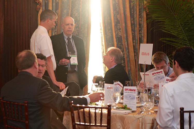
Don Jewell visits the Exelis table at the GPS World Leadership Dinner.
Galas and Awards
The after-hours highlight of the ION GNSS event every year is the GPS World Leadership Dinner or gala, which includes the GNSS Leadership Awards. Only 150 guests may attend, by invitation only, because there are typically more than 1,000 attendees at ION GNSS. This has become one of the “must-attend” events. This year, both Exelis and Lockheed Martin sponsored the dinner along with GPS World, and we are grateful for their sponsorship. Each GPS World editor nominates 10 guests, so be nice to your favorite editor this year and, who knows, maybe you will be among the elite next year (hint, hint)!
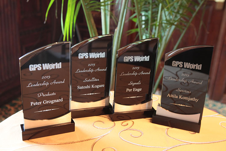
The GPS World 2013 Leadership Awards.
This year, as last, the gala was held in the sumptuous ballroom of the Hermitage Hotel in Nashville, which was built in 1910, exudes Southern charm, and is dedicated to General and President Andrew Jackson, a true son of the South. Harking back to our earlier theme concerning decision-making, President and General Andrew Jackson made many difficult decisions in his tenure and one of his greatest quotes certainly applies:
“Any man worth his salt will stick up for what he believes right, but it takes a slightly better man to acknowledge instantly and without reservation that he is in error.” — Andrew Jackson
And if you can’t quite remember your history, just pull out a $20 bill and there he is.
The food and camaraderie were outstanding as usual. The evening’s entertainment, which is always provided in the form of an original Alan Cameron game that has dinner guests participating in a novel event, this year was based on a clandestine “spoofer” at each table that had to be identified by Q&A only. It was a fine and fun evening, and for the award winners, it was a special evening. Four awards were given this year, to Satoshi Kogure, Attila Komjathy, Peter Grognard and my good friend Per Enge from Stanford. Congratulations to all the award winners — you never know, you could be a guest or an award winner next year. (A full report on this year’s dinner and awards will appear in the December issue of GPS World.)
ION Kepler Award
ION GNSS also presents prestigious awards at this event. This year, the coveted Kepler Award went to a good friend and colleague Dr. John Betz.
Dr. John Betz, winner of the ION 2013 Kepler Award.
Now, the ION GNSS awards committee keeps the name of the award winner totally secret, in a mayonnaise jar on Funk and Wagnall’s front porch. No wait, that’s another award, but they do keep it a closely held secret — so close, in fact, that this year’s award winner’s wife was not in attendance, even though she made the trip with him. So, while I had no idea who would win, I did happen to be sitting at Dr. John Betz’s table, right across from him, when the hints were announced by Dr. Jade Morton, the ION Satellite Division Chair and therefore also the luncheon and award master of ceremonies.
You see, there is a long-held presentation tradition associated with this award. No one knows who has won the award, but the announcement is not just blurted out. Rather, there are about ten hints given about the identity of the person. As the identify of the winner becomes apparent to those in the room, they are asked to stand up, signifying they have determined the identity of the award winner. It was clear to me who had won with the first hint, and of course it was clear to Dr. Betz as well. It was very interesting to watch his facial expression as he realized he had finally won. It dawned on him, and then there was a slight smile, but at the same time a very humble expression.
Dr. John Betz, a MITRE and ION Fellow, certainly deserves this award, and indeed, has deserved it for some time, so it was great to see his considerable accomplishments recognized. And, BTW, remember that you heard it here first: John is working on a book about GNSS that should be published in the next six months. It is not an edited volume, but rather an original work by Dr. Betz, and I for one can’t wait to read it. You can bet I will review it here at GPS World. Congratulations, John.
The other outstanding features of ION GNSS are the excellent and numerous exhibits, plus the time allowed between sessions that provide an excellent atmosphere for networking. And the excellent Nashville Renaissance Hotel, which is attached to the Nashville Conference Center, provided numerous quiet and semi-secluded locations for extemporaneous meetings and is a networking friendly location. The restaurants were excellent, as was the ubiquitous Starbucks barista-manned coffee shop located in the hotel. In other words, Lisa Beaty and her team always manage to choose an event location with accommodations and amenities perfect for this event. I am looking forward to next year in Tampa. Hope to see you there.
What Is Don Reading?
Both books reviewed this month came to my attention because, contrary to the old adage, I was able to tell a good book by its cover.
Phantom, by John Bell.
Phantom An Adventure Novel by Ted Bell
This is a singular novel, frighteningly prophetic in many respects and virtually unprecedented in the multitudinousgrappling-hook approach employed to entice the reader. This is not a criticism, merely an observation, as I obviously thoroughly enjoyed the yarn.
Many novelists “set the hook” by using the old standby, “It was a dark and stormy night…the wind howled, lightning flashed.” Many novelists hook you with rollicking train stories, or Romanoff tales of excruciatingly frigid White Russian winters with Tsars, Tsarinas and Tsarvitches. They hook you with stories of beautiful bounding yachts or fancy racing cars. Or, in the late Tom Clancy style, they hook you with stories of Air Force One and the president versus terrorists, or of course the most modern genre hook concerns terrorism in any guise. In Phantom, Ted Bell does not pick just one of these hooks, he includes them all and more. It is a riveting high-action drama that will keep you turning pages late into the night. The cherry on top of this action-filled sundae of a novel is that the story is really about Singularity (with a capital S), which Ted Bell and many computer scientists today define as “that epic moment in human evolution when artificial, or machine, intelligence (in the form of extremely powerful, superhuman computers) first matches and then exceeds human intelligence by a factor incalculable.”
Author Ted Bell.
In other words, this novel is about all the hooks mentioned, plus it foretells a time when computers obtain parity with and then rapidly exceed human intelligence. Now, if that is not a hook, I don’t know what is. If you are wondering how Ted managed to pull it all together, you will just have to read the book. You won’t be disappointed.
Remember, I was hooked by the cover, and it was not the picture of the beautiful yacht on the cover but rather the quote: “Ted Bell can really write” by James Patterson. Hook, line and sinker.
West with the Night, by Beryl Markham.
West With the Night An Autobiography by Beryl Markham (1902-1986)
The aviation enthusiasts among you may be scratching your heads and thinking, “Wait a minute, where have I heard the name Beryl Markham?” Beryl initially gained fame and notoriety not as a novelist but as a Kenyan-born British aviatrix in the tradition of Amelia Earhart. Indeed, Beryl was the first solo aviatrix to fly the Atlantic eastbound in the pioneering days of aviation. She was also an adventurer and renowned (the first female) racehorse trainer in Kenya, or in all of Africa, for that matter. She married three times, conducted numerous affairs, and was anything but conventional in most every aspect of her life. And, of course, she could write, and write very well. Many of her thoughts are so riveting and presented in such a unique way that you may find yourself going over them again and again just to experience the sheer beauty of her prose. The autobiography covers her early life and upbringing in Africa, and it is a tour de force of the written word. But don’t take my word for it, because this is the quote that caught my attention on the cover of this incredibly well-written piece of literature, that in my opinion should be required reading in every English Literature class today.
Beryl Markham in 1936.
“Written so well, and marvelously well, that I was completely ashamed of myself as a writer…[Markham] can write rings around all of us who consider ourselves as writers…It is really a bloody wonderful book.” — Ernest Hemingway
Until next time, happy navigating. Now, go register for a PNT conference, and then go read a good book.
I have a seven-year-old drawing of GPS satellites in their orbital planes that I found (can’t recall where) some years ago, either on a website or from a colleague who attended some GPS forum. Would you know of a site where I can find current information on GPS satellite locations, which ones have been decommissioned, and which ones have been replaced?
— Grace Pazos
Richard Langley replies:
I don’t know of a plot that shows the locations of all decommissioned and/or replaced satellites (some of them would have been boosted out of the GPS orbit planes), but relatively current information on the active and backup satellites can be found here, and a plot here (and depicted below). I update the table and plot roughly every six months. Earlier versions are available on request.
Constellation snapshot for a specific date/time: GPS week 1749 (725) and GPS seconds 86400 = July 15, 2013, at midnight GPS Time.
Survey Scene Newsletter Mail
Thanks for the insightful update on the ESRI User Conference and the Survey Summit. For those of us who can’t afford to travel, it helps to get the scoop on these events. It is interesting to me that the push towards the future includes heavy emphasis on lighter and simpler small platform apps, cloud-based GIS, and 3D visualizations, and less emphasis on the building blocks of geodesy, cadastral data, and surveying. It almost seems like the GIS community is pushing the hard stuff under the rug and focusing on what is new and shiny. And doing this while talking about higher quality standards.
Keep up the good work, thank you.
— David Scherf, Manager of GIS/Technical Services, Torrington, Connecticut
Eric Gakstatter replies:
Thanks for the comments. If you’ve followed my series “Nightmare on GIS Street,” you’ll see that I’m trying to raise awareness of the importance of geodesy in GIS. I don’t believe that most people are sweeping this subject under the rug because it’s a difficult subject, but just that they aren’t aware that it’s a problem. Secondly, if they do recognize the problem, many don’t know how to solve it. There’s definitely a knowledge gap, and an opportunity for geodesists (or qualified surveyors) to contribute.
Defense PNT Newsletter Mail
Thank you for your tribute to Col. Duke Kane’s many contributions beyond the GPS community. I was also sad to hear of his passing. I met Duke in the late 1980s and watched with considerable interest as he established the GPS International Association.
He felt strongly that the GPS users needed their own forum to voice user interests similar to that which had recently been established for GPS industry via the U.S. GPS Industry Council. His foresight and energy will be missed.
— Jules McNeff, Overlook Systems Technologies, Inc., Vienna, Virginia
Don Jewell replies:
Thanks for your kind words. Of course you and I knew Duke well, and you are correct, he made many significant contributions beyond GPS, even though it was a major accomplishment in which he was always very proud to have had a role to play.
Duke Kane was my uncle, and I can tell you the germinal event that grabbed his interest in flight. While a young boy, Duke and my father Jack (Duke’s older brother) pooled their resources and bought a very popular adolescent novel by Nordoff and Hall (these authors also wrote Mutiny on the Bounty) called Falcons of France, written about two young American boys who volunteered to fly for France in World War I before the United States entered the conflict. Duke’s eyes were set skyward ever after.
It was a dark and stormy night. The winds gusting to over 70 miles per hour drove the snow horizontally, straight into Lynn’s headlights, making it almost impossible to see the road. The outside temperature was -20 degrees Fahrenheit and the roads were treacherous. Lynn wondered for about the hundredth time what he was doing in the foothills of the Rocky Mountains in the middle of a blizzard.
Certainly the day had started innocently enough with several key meetings in Washington, D.C, where Lynn had been for the entire week, and he could not wait to get home. After the last meeting, he made a dash to Reagan National Airport with visions of a quick three-hour flight to Denver and then a short trip south and home to the Rocky Mountains. That’s when things first went sour.
Any seasoned traveler who routinely passes through the D.C. area knows that Reagan National is by far the most convenient airport, but the international Dulles airport is by far the most dependable. Unfortunately, Reagan shuts down for hours with the first raindrop or snowflake, and as luck would have it, a major winter storm slammed into Reagan about the time Lynn arrived, and the flight to Denver was delayed, incrementally of course, for over six hours. The only upside was half the passengers gave up after a couple of hours of repeated 30-minute delays and decided that traveling on Saturday morning was the preferred option.
But not Lynn — oh, no — having spent a great deal of time in airplane cockpits he managed to finagle a conversation with the stranded flight crew, and discovered that the aircraft in question “had” to be in Denver (DEN) before 0500 the next morning for a flight to Seattle, and then on to Anchorage later Saturday morning, so no matter what, the aircraft would eventually get to DEN. So he waited. Sure enough, the 6 p.m. Friday flight finally departed Reagan at 1:15 Saturday morning and arrived in DEN at 2:15 Mountain Standard time.
By the time he woke up the car park personnel and convinced them, with an extra $20 bill, to brave the weather and transport him to the parking lot in Outer Mongolia, where his trusty Audi awaited, it was just after 3:00 a.m. Thus he began his journey south, in a raging blizzard. But he wasn’t concerned because wasn’t his new Audi Q7 Quattro the best four-wheel drive in the world, bar none? At least, that’s what the brochure at the dealership claimed, and Lynn had every confidence his trusty steed would find the barn. What he had not — and indeed could not — have predicted was the incredible knifing pain that struck at about 4:30 a.m. as he was just coming into North Colorado Springs. The sudden excruciating pain seared through Lynn’s leg, and he seriously thought for a moment that he might black out. Indeed, the sudden pain immediately brought back memories of a wound he had suffered in a godforsaken part of the world to the same leg many years before, but unless there was an invisible Viet Cong gunman in his passenger seat, this pain was from another source and it was, if possible, getting worse not better.
So what do you do at 0430 on a Saturday morning in the middle of a blizzard, on a deserted highway, when you are in excruciating pain? Lynn’s first thought was to dial 911, and that was certainly a possibility, but how and when would someone locate him? Mile markers were obscured with snow and the odds were not good. Plus, if the source of the pain was a blood clot brought on by hours and hours of inactivity exacerbated by three hours of sitting in an uncomfortable airplane seat — then he might not have much time. Lynn had heard the occasional apocryphal story of blood clots on airline flights, and the outcome was not always a good one. Supposedly, once a blood clot breaks loose and reaches your heart, lungs or brain, you are pretty much toast. Great, Lynn thought, here I am in pain, slightly panicked by my own imaginings and still in the middle of a blizzard on a lonely highway in the Rockies at 0-dark-thirty with not a clue what to do.
Then it came to him: GPS! He pushed the destination button on the Audi’s built-in GPS unit and dialed down to the “Emergency Locations” tab on the display, pushed the button again, and was immediately rewarded with the choice of the nearest:
Hospital
Emergency Room
Service Station
Fire Station
Police Station
Lynn frantically pushed number one. A female voice boomed forth and notified him that the nearest hospital was only three miles away, and he should take the next exit, which was just becoming visible through the blizzard. Lynn took that exit and within five minutes was in the emergency room of Memorial Hospital North. And since the GPS also gave him the phone number of the emergency room at the hospital and asked if he wanted to dial it, he did. He told the nurse who answered about his sudden leg pain and that he was only minutes out. Lynn was met in the emergency room parking area and placed in a wheel chair. An orderly took his car and parked it, and within about five minutes the excellent medical staff confirmed his worst fears and determined that he did indeed have a blood clot. Massive blood thinners were introduced into his system, and they obviously worked, as he is here today telling his dramatic life and death story to anyone at the Audi dealership who will listen. But it actually becomes a bit more melodramatic; the doctor on call was a cardiac specialist, pulling his emergency room rotation, and he informed Lynn that another ten minutes and it would probably have been too late. Indeed when the medical technicians first imaged the blood clot, it was already on the move, and they just managed to dissolve it before it reached something vital.
The cardiac doc said the only other alternative would have been emergency surgery, which there was not time for, or threading a catheter through a major artery and hoping to find and grab or dissolve the clot before it did any major damage. Obviously, someone on high was looking after Lynn that night. But it also occurred to him as he lay in the emergency room and later in the ICU for follow-up treatment that most likely his GPS and his knowledge of its additional functions had saved his life. According to the doctor, it had certainly saved him from the consequences of a major stroke. All because he had taken the Audi dealer’s advice and spent a few minutes from time to time with the Audi Users Manual, learning about the integrated navigation system and exactly what it was capable of accomplishing when used properly.
Like many advanced automobiles today, the navigation system in the Audi incorporates GPS and wheel sensors with the mapping system, POI (points of interest) database, Internet, Google Maps, 3D maps, Google Streets, radio for traffic and weather updates, and of course the telephone for automatic calls to restaurants to reserve a table or, as in Lynn’s case, to a hospital emergency room for life-saving information.
Fast Forward to Today
This story was brought to mind this Labor Day weekend by events that transpired as my wife and I journeyed south of Colorado to her adopted hometown in the southern part of New Mexico. Like Lynn, we were also in an Audi Q7, in my opinion one of the most comfortable cruising venues you can purchase today, when we came upon a familiar and much-needed service station in the middle of “nowhere” New Mexico, only to discover that while the bio break was possible, fueling the Audi was another matter entirely. It seems the modern-day pumping apparatus requires an Internet connection to validate credit cards, and that system was “temporarily” unavailable. And who carries around several hundred dollars in cash for gasoline purchases today, just in case? For those of you who know what “temporarily” means in New Mexico, you will understand why I immediately began to worry. Even if the pumps had started working at that moment in time, we would have been there for several hours just waiting our turn, and who knew how much gas was in the tanks at the service station and when the intermittent Internet connection might go down again? Our options were to backtrack 100+ miles, or press on and hope for another service station or drive at the most economical speed — for best miles per gallon — which my Audi info system dutifully informed me was 52 miles per hour, and just pray that the fuel quantity sensors were correct and we might just make it to our destination.
However, in a flash of intuition I remembered Lynn’s dealership story. I pushed the “Emergency Services” button and selected the option for the “nearest service station.” Amazingly the system did not select the “out-of-service” station we had just departed, but another one 32 miles closer to our final destination that neither my wife nor I could ever remember seeing before in a tiny village of no more than 100 people. Faith springs eternal, and we were on our way. Sure enough, in about 25 minutes we were fueling the thirsty Audi at a brand-new Phillips station that I swear had not been there during any of our previous sojourns through the blink-and-you-miss-it village. Now, it may not have been a matter of life and death, but who wants to run out of gas in the middle of New Mexico on a 100+-degree day in an area with little if any cellular service? Certainly not yours truly.
My purpose in relating these two vignettes, as humbling as they may be, is directed primarily at the macho types reading this article. Sure, you know who you are, the type that proudly boasts you have never read an instruction manual in your life. The kind of guy or gal that refuses to ask for directions. Well I am here to tell you that when it comes to your GPS — indeed, your hopefully integrated automotive navigation system — get out the book and read it and become intimately familiar with your PNT system, whatever type it may be. It could just save your life.
And before you start that old yarn about, “If I have to read the manual, then it is not user friendly and I won’t use it,” consider the consequences of, friendly or not, being unable to use the system in a real emergency. Even the portable Garmin units that most of us cut our teeth on are integrated to an incredible extent today. It may only seem to plug into your cigarette lighter or, to be more politically correct, your auxiliary power port, but in truth the Garmin and many other portable PNT devices may well be connecting to your mobile phone and your radio for traffic and weather updates. Plus, most of the higher end Garmin units today have an incredibly detailed database with phone numbers and hours of operations for many businesses and, yes, they also have the “Emergency Locations” tab and will guide you to the nearest hospital, give you the phone number for the emergency room, possibly even dial the number, act as a speaker phone and even direct you to the next service station. There’s even a Garmin unit today that will project a heads-up display on your windscreen or windshield.
And unlike your wife or significant other, your GPS will do so without saying, “You were supposed to turn left back there” or “I told you so!”
All major international car-makers are installing telematics units, sending a signal that wireless information and connectivity is here to stay in the vehicle, and location will be a big part of the growth. To learn more about the rapid changes in the connected vehicle field, tune in to our September 19 webinar, hosted by Wireless LBS editor Janice Partyka. Registration is free.
What Is Don Reading?
This month I will quickly review two books that I hope you will find interesting.
Sniper Elite: One Way Trip A novel by Scott McEwen with Thomas Koloniar
Obviously, this very technically correct book is about snipers, and that means it includes data on Seal Teams and Delta Force. But more importantly, this novel puts forth a warrior’s perspective of women in combat, and the actions taken by their fellow comrades in arms to keep them safe and rescue them if necessary. Indeed, the whole story revolves around Seal Team Six and Delta Force fighters that are deployed to free a captured female helicopter pilot from the 160th Special Operations Aviation Regiment (SOAR) — in other words, one of their own — who is being held, interrogated and brutalized by Taliban insurgents in Afghanistan. Throw in D.C. political intrigue and a president running for re-election who has his own opinions about women in combat and you have a real page-turner.
GPS capabilities and units are mentioned throughout the book, and referred to when it is absolutely critical that warriors know exactly where they and their targets are located. It is clear that entire missions would be lost without the capabilities that GPS enables.
It is a gripping read that grabs you from the first page, and again, it is tough to put down. It is even good enough that you might want to read it more than once. And yes, if this sounds familiar, both McEwen and Koliniar wrote the #1 New York Times bestseller American Sniper, which I also highly recommend.
Ike’s Spies: Eisenhower and the Espionage Establishment An historical biography by Dr. Stephen E. Ambrose with an introduction by Douglas Brinkley
The historians among you should recognize Dr. Stephen Ambrose’s name and associate him with perhaps the most prolific chronicler of our day concerning the life and times of President (General) Dwight David Eisenhower.
Dr. Ambrose, a renowned historian, authored more than 30 books in his lifetime and more than half of them concerned Dwight David Eisenhower during some key period of his life.
The film rights to two of his more famous books were purchased by Steven Spielberg and Tom Hanks, who used Citizen Soldiers and Band of Brothers to make the 13-hour HBO mini-series Band of Brothers.
Dr. Ambrose once described his writing style: “As I sit at my computer, or stand at the podium, I think of myself as sitting around the campfire after a day on the trail, telling stories that I hope will have the members of the audience, or the readers, leaning forward just a bit, wanting to know what happens next.” And this is just the style that makes this history a page-turner. Even though you may know the outcome of the historical event, it is the insider’s view that makes this book such a fine read.
Until next time, happy navigating, and read a good book — but first get out your GPS device owner’s manual or look it up on your iPad or computer for video tutorials, and peruse them for awhile. It could save your life one day.
Painting of Colonel Francis Xavier Kane (courtesy of the USAF Space and Missile Pioneers).
Plus: The First Installment of ‘What Is Don Reading?’
This month I planned to catch up on all those important topics that need to be written about but don’t make the cut, mainly due to space limitations — and then came the sad news of the passing of a good friend, mentor, and great Space and Missile Pioneer, Colonel Francis Xavier Kane, Ph.D., USAF Retired, born on December 12, 1918, in Philadelphia, Pennsylvania. To put this date in perspective, consider that the first successful Wright Brothers flight at Kitty Hawk occurred in 1903.
Known simply as “Duke” to his friends and colleagues, he went to be with the Lord on July 18, 2013. He was 94 years old, and the majority of those years were filled with futuristic thoughts and writings about what we could achieve in the heavens above us, and accomplishments that support the Space Age we all live in today.
I first met Colonel Kane in 1973, a full three years after he retired with 27 years of active duty in the USAF. Duke graduated from the U.S. Military Academy at West Point in 1943 in the middle of WWII. In those days, there was not an U.S. Air Force Academy. What would become the U.S. Air Force was then known as the Army Air Corp. The USAF did not become a separate military service until September 18, 1947, with the implementation of the eponymous National Security Act. Still, Duke found himself in an Air Force uniform, flying airplanes and instructing others how to fly. He loved flying, but as you will soon discover, he was an engineer and professor at heart. He played to his strengths.
I never knew Duke while he was in uniform. Despite my best efforts to refer to him with proper military courtesy as Colonel Kane, he quickly remonstrated me and informed me that to his friends and colleagues he was known simply as Duke, and so “simply Duke” it has been for the last 40 years. At the end of our conversation about appropriate appellations, he added, “And no one calls me Francis-Xavier except my wife Virginia, and then I know I’m in the dog house!” (Ed: Duke and Virginia were married for 67 years).
Duke Kane was the first to send me a wonderful handwritten letter of congratulations via snail mail back in 2007, when I penned my first column as the Defense Editor for GPS World magazine. The letter was extremely complimentary, with high praise I had certainly not yet earned, but then that was Duke — always supportive. Comments in his letter I will always treasure are “Finally, we have someone writing regularly about GPS that actually knows what he is writing about…and don’t forget, Don, I have declassified history files dating back to the early days of the 621B program and they are always at your disposal.”
I heard regularly from Duke, several times a year at least, and it was always a note of encouragement or praise; what every journalist needs. It meant a lot to me personally that it came from Duke because, you see, Duke was a very prolific writer and thinker himself, and perhaps at times even a frustrated journalist. Some of his wonderful and insightful writing on the possible uses of the “Space Domain” as a medium for our future infrastructure are seminal and even legendary today — such as the one he wrote on terrestrial navigation using space assets, which helped spawn the aforementioned 621B program that led to the Global Positioning System. More on that later.
Duke was a prolific writer, but rarely took credit for his futuristic ideas. While serving as an Air Force planner, Duke penned papers concerning the initial development and importance of systems analysis and applications of early computers for both terrestrial and space applications. Early on, Duke saw the need to develop a coherent planning and policy environment in the DoD (Department of Defense) to enhance the evolution of and to formally inculcate the U.S. space program, to include systems and technology planning.
In the early 1960s, Duke wrote profusely concerning space-based missile warning, known today as the DSP or Defense Support Program and more recently as the SBIRS or Space-Based Infrared System. He wrote about manned space maneuvering vehicles, now known as the Space Shuttle, which came and went during his lifetime, as well as the detection and tracking of mobile missiles and the possibility of shooting them down with lasers. He also wrote about lasers as “blindingly effective” anti-satellite weapons, a capability and problem that modern planners and operators are still worrying about and dealing with today. He wrote about advanced ballistic missiles, which we know today as the MX or the Peacekeeper program.
He was always ahead of his time. He wrote knowledgeably about space-based missile defense, a theme he would later revive as a member of the GPS Independent Review Team (GPS-IRT), which several of us invited him to join because in the 1960s he penned significant white papers concerning the possibility and credibility of navigation satellites, which of course we know today as the Global Positioning System. He was, in many respects, a visionary.
Before his retirement in 1970, Duke managed to find the time to complete a master’s degree in political science and a doctorate from Georgetown University. He went on to teach courses at UCLA, the University of California at Los Angeles, the Catholic University of America, and Pepperdine College.
Duke loved to think and write about the future. One of his favorite topics was the Global Positioning System, which in many respects sprang from the classified 621B program he supported toward the end of his Air Force career.
Aerospace Corporation Historian Steven R. Strom, in his insightful writings and interviews with luminaries of the early U.S. space programs, with an emphasis on the history of GPS, wrote that in 1963 the Air Force Space Systems Division funded Colonel Kane to lead a classified project known as 621B. Phase one of 621B featured the engineering concept for a “space-based navigation system,” later to become known as the Global Positioning System or more formally as the GPS/NAVSTAR. According to Colonel Bradford Parkinson, Ph.D. USAF, retired — and the first GPS Program Manager/Director at what is now SMC — Project 621B had “many of the attributes that you now see in GPS. It has probably never been given its due credit.”
Duke never forgot those early days or got over his involvement and fascination with GPS. In 1993, 23 years after his retirement from active duty, Duke founded the GPS International Association. He served on the U.S. Department of Transportation Civil GPS Service Interface Committee and authored more than 20 significant articles on GPS and other critical space-based systems.
Finally, in 2010 Duke was inducted as an Air Force Space and Missile Pioneer — his picture and a short biography hang in the entryway of AFSPC (Air Force Space Command) Headquarters (the Hartinger building) on Peterson Air Force Base in Colorado Springs, Colorado — a well-deserved honor of which Duke was extremely but humbly proud.
Colonel Francis Xavier “Duke” Kane — fighter pilot, flight instructor, engineer, professor, visionary and, for many, a friend and mentor who will be sorely missed.
Now on to the Catch-up Topics…
As my regular readers are aware, I generally take a long time to evaluate PNT and PNT-related equipment sent for me to review, and I only review about one in twenty items. For years I have reviewed and recommended OtterBox equipment for keeping iPads, iPhones and assorted PNT handhelds safe from the environment. They are indeed some of the best add-on “ruggedizers” I have ever encountered. However, a few weeks ago I called the wonderful folks at OtterBox to enquire about a rugged mounting system for PNT equipment and discovered to my dismay that they just don’t do that. Not an area of expertise for them. Fair enough, and I certainly appreciated their honesty. Then, out of the blue, I received an email from Francesca Marino at Blast Media on behalf of Rokform, a relatively new U.S. company that builds rugged mounting systems that she said were perfect for our warfighters. She even included the following advertisement/vignette:
Made in the USA, all Rokform products are designed and engineered of CNC aircraft grade aluminum. Each accessory allows soldiers to mount their phone magnetically, or by Remote Mounting System (RMS), to dashboards of any vehicle. A member of the Navy inland search and rescue team accounts his experience with Rokform’s RokBed v3 case while on duty for helicopter rappel operations:
“I’m active duty military, and one of our engineers bought the magnet for his [Rokform] case as I had. While standing on the quarterdeck, he accidentally dropped his phone and tried to kick it back onboard before it went in the drink. He only succeeded in kicking it overboard…only to have it catch itself on the side of the ship! Several others saw what happened and were surprised when he was able to retrieve his phone from its watery grave! I had to share that story as you had to be there to believe it.”
Francesca asked if I would be interested in receiving a sample of a Rokform rugged smartphone or iPad case for testing.
I took Francesca up on her offer, and frankly, I am impressed with the earth-magnet mounting system on the Rokform equipment cases, and especially with the v3 mounting system (see picture). I have used the v3 for a couple of months in numerous rental cars and with both my iPhone and my iPad — it works flawlessly. It has never released involuntarily even on hot and cold surfaces, and it has never dropped my iPhone or iPad on the dash. Not something I can honestly say about any other device of this type I have tested. I also use the v3 at home on a granite counter top Sometimes just getting it unstuck is a chore, but a happy one. It simply works as advertised; it holds whatever you attach securely and effectively, and has the flexibility and maneuverability to do so in all kinds of environments. It is truly rugged, versatile and very useful. It stays where you mount it, and it is made in the USA. I highly recommend it.
The Rokform v3 mounting system.
Specifications:
There are numerous hands-free options for the v3 Suction Mount. Attach the mount to any smooth, flat, non-porous surface, and adjust to your ideal viewing angle. A few of the locations I tested include a conference table, desk, car window, windscreen, mirror, and sunroof.
Features
Polycarbonate and die cast zinc construction
360-degree turn and rotation
210-degree tilt for ideal viewing angles
Powerful suction pad measures 3.4 inches (86.4 mm) in diameter
The v3 is compatible with all v3 mountable phone cases, which pretty much covers the waterfront on phone cases, and so they should have one that fits your needs.
There is a separate attachment for your mobile devices that uses adhesive if you just don’t want to use the suction cup model — just beware that once you attach the separate small earth-magnet device, to a case or your automobile, it is not coming off. Be sure you want it there permanently. I view this as a good thing: no falling iPhone or iPads. But it is just something you need to contemplate. Of course, the v3 works with a tenacious suction cup, so there is not a permanence issue with that device. Try it.
What Is Don Reading?
Ever since I started penning this column and mentioning books I have read or am reading and frequently quoting from them, I have received a steady array of requests to discuss the books and recommend or review them, even if they are not primarily about GPS or PNT.
Certainly, locating books to review is not an issue. My wife calls me a parallel reader, in that I am generally reading two, three, even four books at a time. The question is will any of them be of interest to you? Let’s find out. While we are not sure this feature will appeal to all of you, or if we can make this a regular feature due to time and space limitations, we will give it a trial run this month. Please let us know what you think and what you are reading that may be of interest to our readers, at [email protected].
I recently had the pleasure of reading two books about wartime that cover two distinct periods of time and are actually in different genres. However both books are fascinating for very different reasons.
Viper Pilot: A Memoir of Air Combat, by Dan Hampton (USAF, Ret).
This book is a “must-read” for air combat aficionados in that it is a seat-of-the-pants warfighter, fighter-pilot view of the air wars in Iraq, Afghanistan, and Kosovo. It is also a very candid fighter pilot’s view of how those wars were managed or not managed, as the case may be. Dan certainly pulls no punches, and if you have any romantic visions of aerial combat and how it comes about — as portrayed in movies like Twelve O’Clock High — then this book may prove to be an eye-opener.
Be warned, it takes a chapter or two for Dan to set the hook, but if you are still engaged by chapter three, you should be good and firmly on the line. The first two chapters are more of what those of us in-the-business refer to as standard fighter-pilot rhetoric, as in “I am god’s gift to the world and am without a doubt the world’s best fighter pilot.” Indeed, the first two chapters do a good job of substantiating the old barb, “You can always tell a fighter pilot, but you can’t tell him much.” Today, to be politically correct, I guess that would have to be him or her much.
However, in retrospect, who would want to read a book by a warfighter, especially an F16C Wild Weasel fighter pilot, who was not absolutely sure of his or her superiority? Not me. Indeed, another old barb that applies here, “There are bold pilots and old pilots but very few old bold pilots.” After you read Viper Pilot, I think you will agree than Dan Hampton, who by his own humble admission is one of the most decorated F-16 pilots in American history, is certainly the exception to the rule.
Most importantly, Dan Hampton gets it right, technically and operationally. His frustration with incompetent ground-pounders and support personnel notwithstanding, he tells it like it is, and you quickly detect that his frustrations are probably justified and his feelings, which he freely shares without compunction, are certainly justified, at least in his view of the world.
As far as I can decipher, and I was in that business for almost thirty years, there are no glaring errors or even small mistakes about procedure, process, or organizational charts. He tells it like it is and lets the pieces, whether blame or commendation, fall where they may. It is a great read, and one that all history, war, airplane and aerial-combat buffs will find a must read. And yes, there are numerous references to GPS and GPS-guided weapons and effects. I thoroughly enjoyed it — even though the language can at times be a bit over the top and is totally unnecessary to the storyline, but then, when you are God’s gift to fighter pilots, what do you expect?
By the way, rumor has it Dan is in the process of writing another book. I, for one, can’t wait.
The Ledger, by Lloyd Holm
This wartime romantic novel by Lloyd Holm is certainly a departure from Viper Pilot. This book is romantic in nature, but in a good way, and yet is also a very true and authentic synopsis of what it was like during both WWI and WWII, which was globally known as the “War to end all Wars.”
Lloyd Holm does a great job of setting the hook immediately. No waiting. I read it in one sitting and was disappointed only because it was over. I wanted the story to go on and on. Hint to Mr. Holm: There is certainly a sequel here if you have it in you.
This fast paced riveting story concerns two families and their involvement with each other during both world wars. The story more or less begins with a very authentic and well-documented event, the 1914 lull in fighting due to the spontaneous and unofficial 24th of December Christmas Truce during WWI. Both Allied and German soldiers meet in “No Man’s Land” between the trenches to exchange food, stories and camaraderie. During this incredible event, the lives of two families, German and Jew, become irrevocably intertwined — the rest, as we say, is history and the storyline of The Ledger.
This wonderful book is authentic and detail oriented. I could find no fault with the well-documented history, the unit designations, or the language, as English, French, and German words are used liberally and in the correct context.
Whether you read this book as an historian, a romantic, or a war buff, you will find it satisfying on all accounts, and I dare you to put it down once you start. Sequel?
Until next time, read a good book and happy navigating.
I keep waiting for the cryptic phone call or emphatic email from Trimble that says, “You have had our evaluation units for over four months — when can we expect to see a review and when will you be returning our equipment?” Fortunately, Trimble is very understanding and would never make such a call or send such an email, I hope. The truth is Trimble sent me a T41 and Yuma 2 for review back when it was still snowing in the Rocky Mountains and I am still evaluating the units. You see that’s the rub with excellent equipment — it is a pleasure to review GPS equipment that exceeds all expectations, and frankly, it is difficult to send it back because there is always one more project, one more test or one more application that needs to be run. Fortunately the Trimble PNT equipment (position, navigation and timing) has never been found wanting. So here finally is the T41 review that so many of you have requested.
First, however, for those of you who are of a similar age to yours truly — and let’s just say it hopefully relates to a certain level of maturity and in my case familiarity with GPS since 1978 — I just can’t see the designation T41 without thinking of: (1) a basic USAF pilot and navigation training aircraft once flown at Mather Air Force Base in California and one I still see every day at the Unites States Air Force Academy and flying over my home on a regular basis, and (2) the first successful commercial GPS unit built by my think-tank colleague Philip Ward at Texas Instruments, designated the T1-4100. I have no idea if Trimble was aware of these associations when naming conventions were considered for the T41, but for many of us seniors the associations certainly exist. That is not a bad thing — it probably even extends to goodwill in a business sense, if you understand that jargon. But, as usual, I digress!
BLUF (Bottom Line Up Front)
As loyal readers are aware, I never give a product a bad review. That is not to say I do not receive my share of simply “bad” GPS equipment to review. I just refuse to take the time to pen a bad review — my philosophy being, why should I take the time to write and why should you take the time to read about something you can’t or won’t use? There are enough “good,” even exceptional, GPS devices out there today that deserve to be written about — so let’s just skip the bad ones and save us all some grief and deflated expectations. So the very fact that I am writing about the Trimble T41 means that it has passed all my tests for ruggedness and usefulness. In fact (I checked the figures with my review logs for the past seven years), for every 20 GPS devices I receive, I only review one on average. This month it is the Trimble JunoT41/5 X-Model with gray pin striping and an IP68 ruggedness rating, and you will see why that level of model detail is important shortly.
Who Matters as Much as What
Before I get into the technical aspects of the T41, let’s consider for a moment who would want to use this unit. Without a doubt, it is perfect for warfighters and first responders or I probably would not write about it, but it is also perfect for anyone that needs a rugged handheld computer with embedded GPS running either the Windows or Android operating system (OS). The touchscreen display covers about the same real estate as the new iPhone 5 but the T41 is slightly larger, heavier, thicker and, it almost goes without saying, incredibly rugged. I guess that is why I have received several letters from T41 users that use it on horseback.
Now, while I perceive the equine GPS market to be a niche market, another one of my think-tank colleague, the Honorable Jim Geringer, who ran the great state of Wyoming from 1995 to 2003, has mentioned several times in passing, and I mistakenly thought jokingly, ranchers using GPS on horseback. Now that I think about it and read some of my email from Colorado, Wyoming, and Montana ranchers, it makes sense. Think about navigating thousands of acres of ranch land that in some cases all looks the same, looking for lost cattle or damaged fences. Think about wanting to mark the spot where cattle or damaged fences were found and then being able to quickly communicate that information to someone who could help, and then just as quickly navigate back to civilization, even in a blizzard. The fact is my correspondence from several ranchers tells me that GPS has become indispensible – and not just any GPS, but a reliable, accurate and rugged GPS that has a long battery life, comes with a built-in camera, and the option for a solar charger, and of course has embedded communication capabilities. Sounds a great deal like the T41 – I think you will agree.
Basics and Specifications
The Juno T41/5 approximates a slightly larger iPhone 5 in size, but one with an extremely rugged case. The case makes it bigger and heavier, but at the same time much more useable in all weather conditions, to include snow, ice, water, dust, all of which I personally tested for, and I suspect it will survive being dropped in horse manure, although I will admit this is one test that I have not personally performed. I will graciously defer to my equine mounted readers when it comes to performing this particular test. Can you say rubber gloves, Purell Hand Sanitizer and Fabreze?
Trimble Juno T41/5 Specifications
FEATURES
Processor: 800 MHz or 1 GHz, Texas Instruments DM3730
Microsoft Office Mobile 2010 (Word Mobile, Excel Mobile, PowerPoint Mobile, Outlook Mobile)
Internet Explorer Mobile 6
Microsoft My Phone with SMS Text Messaging
Camera Control Application
Flashlight Control Mode Application
Calculator
Calendar
Microsoft Pictures and Videos
Windows Media Player
Windows Live Messenger
Microsoft Task Manager and Notes
Adobe Reader LE 2.5
Android 4.1 Advanced Software:
Trimble Outdoors Navigator
Email
Phone and SMS Text Messaging
Picture and Video Gallery
Multimedia Player
Web Browser
Camera Control Application
Flashlight Mode Control Application
Application Developer Support:
Software Developer Kit with Documentation for WEH 6.5
Software Developer Kit with Documentation for Android 4.1
STANDARD ACCESSORIES
International AC Charging Kit
T412 USB Cable
Wrist Strap
Ultra Clear Screen Protectors (qty-2) Kit
Quick Start Kit
OPTIONAL ACCESSORIES
9-pin Serial Adapter
USB Host Adapter
Capacitive Stylus with Tether
External Battery Pack
Port Cover
Ultra Clear Screen Protectors (qty-10) Kit
Anti-reflective Screen Protectors (qty-2) Kit
Vehicle Charging Kit
Capacitive Touch Screen Gloves
Trimble Headset
External GPS Antenna
ENVIRONMENTAL SPECIFICATIONS
Water: Survives immersion at 3.3 feet (1 meter) for two hours (gray models), IEC-60529 IPx8. Survives driving rain & water spray (yellow models), IEC-60529 IPx5, water jet 12.5 mm diam @ 2.5-3 m. Dust: Protected against dust, IEC-60529 IP6x, dust chamber with under-pressure Drops: Survives multiple drops of 4 ft. (1.22 m), MIL-STD-810G, Method 516.6, Procedure IV, Transit Drop Operating Temperature: -22 ºF to 144 ºF (-30 C to 60 C), MIL-STD-810G, Method 502.5, Procedure I, II, III (Low Temp Operating -30 C); Method 501.5, Procedure I & II (High Temp Operating 60 C) Storage Temperature: -40 ºF to 158 ºF (-40 C to 70 C), MIL-STD-810G, Method 502.5, Procedure I, II, III (Low Temp Storage -40 C); Method 501.5, Procedure I & II (High Temp Storage 70 C) Temperature Shock: Cycles between -22 ºF and 144 ºF (-30 C and 60 C), MIL-STD-810G, Method 503.5, Procedure I-C Humidity: 90% relative humidity with temperatures between 22 ºF and 144 ºF (30 C and 60 C), MIL-STD- 810G, Method 507.5, Procedure II Altitude: 15,000 ft (4,572 m) at 73 °F (23 C) to 40,000 ft (12,192 m) at -22 °F (-30 C), MIL-STD-810G, Method 500.5, Procedure I, II & III Vibration: General minimum integrity and loose cargo tests, MIL-STD-810G, Method 514.6, Procedure I & II, Category 5 Solar Exposure: Survives prolonged UVB exposure, MIL-STD- 810G, Method 505.5, Procedure II Chemical Exposure: Resistant to mild alkaline and acid cleaning solutions, fuel hydrocarbons, alcohols and common vehicle and factory machine lubricants.
PHYSICAL
Size. . . . . . . . . .6.1 in . 3.2 in . .9 in (15.5 cm x 8.2 cm x 2.5 cm)
Weight. . . . . . . . . . . . . . . . . . . . 13.5 oz (.4 kg), including battery
Color . . . . . . . . . . . . . . . . . . .Black with Yellow or Black with Gray (Color does make a difference; see Product Models below.)
ELECTRICAL
Processor: 800 MHz or 1 GHz, Texas Instruments DM3730 Memory: 256 MB or 512 MB Storage: 8 GB or 16 GB, non-volatile Expansion: micro SD card slot, SIM card slot Display: 4.3 in (10.9 cm), 480 x 800 pixel, WVGA TFT Battery: 3.7 V, 3.3 Ah, 12.2 Wh, Lithium-ion polymer I/O: 3.5mm audio jack; Custom Port that supports USB 2.0 Host, USB Client, 9-pin Serial and 5.6 V (5.0 V to 5.9 V) DC input power GPS Receiver: 2-4 m accuracy with WAAS/SBAS correction; MCX port for optional external antenna Radios: Bluetooth 2.1 +EDR; Wi-Fi 802.11 b/g/n WWAN radios: UMTS / HSPA+, GSM / GPRS/ EDGE; UMTS Bands (WCDMA/FDD): 800, 850, 1900, AWS and 2100 MHz; GSM Bands: 850, 900, 1800, 1900 MHz
CERTIFICATIONS
FCC, CE, R&TTE, IC (Canada), C-tick, GCF compliant, RoHS compliant, Section 508 compliant, PTCRB, SAR, AT&T network compatible, Wi-Fi Alliance certified, CCX, USB 2.0 Full Speed, MIL-STD-810G, IP65/IP68, MIL-STD-461E.
PRODUCT MODELS
Color
IP Rating
Processor
RAM
Storage
WWAN
GPS
Camera
M
Gray
IP68
800 MHz
256 MB
8 GB
–
2-4 m
–
C
Yellow
IP65
800 MHz
256 MB
8 GB
–
2-4 m
8 MP
C
Gray
IP68
800 MHz
256 MB
8 GB
–
2-4 m
8 MP
X
Yellow
IP65
1 GHz
512 MB
16 GB
3.75G
2-4 m
8 MP
X
Gray
IP68
1 GHz
512 MB
16 GB
3.75G
2-4 m
8 MP
The M model features a GPS receiver, 800-MHz processor, 256 MB RAM, 8-GB storage and is available in gray with IP68 rating. The C model adds an 8-megapixel camera with dual LED flash, Bluetooth and Wi-Fi to the M model feature set and is available in yellow with IP65 rating or gray with IP68 rating. The X model adds penta-band GSM cellular phone and data capability to the features of the C model, has a 1 GHz processor, 512 MB RAM and 16 GB storage and is available in yellow with IP65 rating or gray with IP68 rating.
Key Features
WVGA Sunlight-Readable Gorilla Glass Display. I found the 4.3-inch color display to be readable in all lighting conditions. From very low light to bright sunlight, even sun reflecting off snow, which I have found to be the most difficult condition. The Gorilla glass is aptly named, as its unique composition allows for a deep layer of high compressive stress, which is created through an ion-exchange process during the manufacturing process by Corning Glass. This compression acts as a sort of “armor,” making the glass exceptionally tough and durable, and yet the display is crystal clear.
Multi-Touch User Interface with Capacitive Stylus Compatibility. Now, I am well aware that one of my heroes, Steve Jobs, once said that “…if you are required to use a stylus on a computer, you have lost your advantage.” However, there are just simply times, especially with GIS (geographical information systems) and map displays, when something smaller and more accurate than the end of your little finger is called for, and on the T41 you have your choice. The display also functions with a capacitive glove, which you can purchase from Trimble as an option or from many other vendors. The bottom line is the 4.3-inch high resolution screen is very clear, and as Trimble says “…the multi-touch support allows complex selections and controlled zoom to optimize the user experience with maps and detailed information.”
3.75G Cellular Data, Text and Voice Capability. A GPS or PNT device today without communication capabilities is a device that simply cannot compete, in the marketplace or in any situational awareness competition/situation you would care to name. Communication capabilities allow any PNT device to make use of PNT augmentation available over the Internet and through private networks such as the Trimble VRS or Virtual Reference Station and the John Deere StarFire network. Indeed, the Trimble VRS network enables precise, real-time GNSS positioning through the distribution of correction data. The global networks provide a highly reliable method for surveyors, warfighters, and other geospatial and PNT professionals to work faster and achieve accurate GNSS results, as precise as three centimeters in real time, for a variety of positioning applications including geodetic and cadastral surveying, road and bridge construction, mapping, agriculture, earthquake and tectonic plate movement monitoring, warfighter applications, and scientific research, as well as other high-accuracy positioning applications. Trimble’s VRS networks use RTK (real-time kinematic) solutions that, when combined with the Trimble RTKNet software, provide high-accuracy RTK GNSS positioning for wide areas. A VRS network improves productivity while reducing complexity and the global footprint for warfighters, by eliminating the need to set up a base station.
A VRS network is made up of the latest in GNSS hardware, modeling, and networking software, plus communications interfacing. Once set up, RTK roving receivers in the field or AOR (Area of Responsibility) have access to real-time network modeled corrections. In the field you also have the reassurance of the built-in integrity monitoring system that warns if there are any problems with the data.
Today Trimble’s VRS networks are considered an integral tool for providing fast, high-precision, wide area positioning for warfighters and first responders in countries around the world. The Trimble VRS and John Deere RTK StarFire systems also give the device, especially in the case of a warfighter, additional situational awareness, along with the capability to act not only as a receiver, but as a networked device, a sensor, and a monitoring station. The T41 handheld has voice, SMS text, and 3.75G cellular data transfer capabilities on GSM cellular networks worldwide. You can upload and download data from the cloud using Wi-Fi or WWAN connections. The 8-megapixel camera can be set to automatically include time and location metadata from the GPS receiver. The T41 not only has the ability to increase the individual warfighter’s situational awareness but to increase the SA for all users on the network and in the AOR as well.
Bluetooth 2.1 + EDR and Wi-Fi b/g/n. You may well wonder why I have listed this as a separate feature when it could just be included under communications. I have listed it separately because of the Army’s laudable Puck and Hub endeavors.(See my GPS World May column for the detailed briefing). Without going into too much detail, the Puck and Hub are sorely needed PNT receivers with augmentation capabilities to include Wi-Fi, inertial, and CSAC (Chip Scale Atomic Clocks) that are hopefully multi-GNSS signal-capable. The only feature both devices lack is a suitable and rugged display mechanism. This is where the Bluetooth, Wi-Fi and Android capabilities of the T41 come into play. The Army seems, for the time being, to have mysteriously settled on the Android OS as a basic capability and building block that, when combined with Bluetooth and Wi-Fi, make the T41 the perfect display device. I cannot say much more in this venue, but take my word for it when I say I have never tested another purpose-built rugged PNT-capable device more suitable for the Army’s Puck and Hub applications. Suffice it to say that Software Developer Kits (SDK) for both Android and Windows OS enable custom application software to easily interface, wired and wirelessly, with the many built-in sensors, radios, and data ports on the T41. For instance, a secured Bluetooth signal embodied in the 2.1 and EDR (Enhanced Data Rate) specifications would allow users to transfer data to and from the Puck or Hub while maintaining voice or SMS connectivity with other networked users and commanders, who are able to make faster and hopefully better decisions based on real-time information.
GPS Receiver with 2-4 Meter Accuracy. At its core, the T41 is indeed a GPS receiver that is SBAS (Satellite Based Augmentation System) capable, which means it can take advantage of the augmentation and integrity signals from the U.S. WAAS (Wide Area Augmentation System) and the European EGNOS (European Geostationary Navigation Overlay Service). However, when combined with the device’s prodigious communications capabilities — Wi-Fi, Bluetooth, and the Internet — the device becomes a truly multi-GNSS capable receiver with ports that can, hopefully in the future, accommodate such devices as the CGM (common GPS module) that includes SAASM (Selective Availability Anti-Spoofing Module) and M-Code capabilities. It also includes the Trimble and John Deere networks as mentioned earlier, and this gives the device the capability of 3-centimeter RTK accuracy. Think about it: I have never heard a warfighter say, “I need a less capable, less versatile and less accurate device.”
Accelerometer and Electronic Compass. Ask a warfighter if he needs an accelerometer, and he might scratch his head, but ask about an electronic compass and the answer is an emphatic yes. Think map reading, orienteering, and getting out of Dodge fast. Think urban canyons or vast, featureless deserts where a warfighter has no intrinsic idea which way is which. That’s when you need a compass, but an accelerometer —as any iPhone aficionado will tell you — is almost indispensible. The accelerometer detects physical movement and is primarily used for motion sensing and tilt controls. It also detects vibration and acceleration, allowing the T41 to detect the distance and speed it has moved in three-dimensional space. Combined with the right software, it may prove to be a key component of determining position, distance, and speed in challenged environments.
Nine-Pin Serial and Power Port.The last feature I will highlight about the T41 is the nine-pin serial data and power port. The serial cable is secured to the T41 for power and data by a secure data/power cable that is attached with thumb screws on one end and by a USB connector on the other. In rugged environments it provides both a secure means of power from multiple sources and a universal data connector, neither of which are going to work their way loose and leave you with a dead battery or no data. It is almost legacy in design, but innovative in that one multi-function cable provides power and serial data inputs. I used it for both power and data and it worked flawlessly — plus I never had to worry about a loose or lost connection.
Bottom Line
The bottom line is I highly recommend the Trimble Juno T41 in any of its configurations, which are many. It is rugged to a fault, sturdy and has one of the best displays I have ever seen. I reviewed the Windows OS version but have no doubt the Android OS works equally well, and that is, after all, the OS on which the Army is pinning its future plans and hopes for PNT devices. However, as I said in the beginning, I do not want to limit this device to the warfighter. It certainly fills the bill there, but it also competes well and indeed exceeds the capabilities of many similar devices that lack the built-in ruggedness and the Trimble reputation for consistently producing superior devices. This review is already 3,500 words, and I could easily write another 5,000 words, but hopefully you get the point. If you need a very rugged phone, a computer in a handheld form factor with embedded 3-cm level GPS capabilities that sports a crystal clear display and is a device with huge growth potential, then the T41 is exactly what you need. I know of nothing better in the marketplace today. It is really going to be tough to send this one back.
Now I wonder just how long I can keep it before that dreaded emphatic phone call or cryptic email…
Until next time, happy navigating and give the T41 a test-drive.
Editor’s note: Readers interested in owning a Juno T41 can enter a GPS World drawing by filling out our State of the Industry Survey.
I first met just-pinned-on, shiny and bright, Captain Bernard Gruber-USAF in 1992. Bernie had just arrived at the Space and Missile Systems Center at Los Angeles Air Force Base in California where he would hold several important positions.
For those readers not aware of the mission and importance of the Space and Missile Systems Center (SMC), today SMC, which began in 1954, is the nation’s center of technical expertise for military space acquisition with more than 5,000 employees nationwide and an annual budget of $10 billion.
Bernie’s first association with GPS at SMC was as the chief of User Equipment Production at the then NAVSTAR Global Positioning System Joint Program Office (GPS-JPO). He went on to serve as the program manager for Foreign Military Sales (FMS), working with our allies, and then as the program manager for Advanced Military Devices, which is a euphemism for things we can’t discuss in this venue. All this in a short 40-month time frame, which is almost as long as he has served in his current capacity as the director of the Global Positioning Systems Directorate, now 21 years later. As a young starry-eyed captain, I remember Bernie as energetic, dedicated and full of ideas, which pretty much describes him today as he completes his last active duty assignment and his 26-year U.S. Air Force career draws to a close.
While it may be fair to say that Bernie had some notion of what to expect when he was assigned as the commander of the GPS Wing in 2010, he actually had no idea of all the tremendous and mostly positive changes that would occur to the GPS program under his watch.
I thought it would be fitting to conduct an exit interview with Bernie during his last full month on the job and get his opinion concerning the changes to GPS during his tenure and the probable way ahead for GPS as he turns over the reins.
Don Jewell (DJ): Colonel Gruber, thanks for taking the time to speak with us today. I know you are extremely busy and your time is running short at SMC. Bernie, you have certainly lived the old Chinese adage, also sometimes described as a curse, during your tenure as the GPS Wing Commander and as the director of the GPS Directorate, “May you live in interesting times.” Your tenure has been beset with one major challenge after another and yet you have persevered and — I think this is something for which you will be remembered — you have consistently turned those challenges into opportunities. Let’s discuss some of the opportunities.
Certainly sequestration and budget issues are big topics today. Having come from the Pentagon and having worked on the financial side of GPS, were you surprised by what you found when you took over as the GPS Wing commander? Was it all you expected it to be? The big question seems to be, how is sequestration going to affect the future of the GPS?
Colonel (USAF) Bernard Gruber (BG): Well, Don, certainly budget issues are a key topic today, but let me say before we get started on the questions and answers that I really appreciate the opportunity to speak with you and your readers at GPS World. As you said in your introduction, these have certainly been interesting times. Some people may call it crazy but they are certainly interesting, nonetheless.
I must say that I was pleasantly surprised how much had changed on the [GPS] program when I came back to SMC, and the changes were really all for the good. It warmed my heart to see the Foreign Military Sales [FMS] office — which I actually started back in 1992 — now has agreements with 55 nations, and military sales continue to increase year-by-year. I was also very happy and surprised to see the SAASM or Selective Availability and Anti-Spoofing Module program, which I was actually the program manager for in its infancy, has now been installed on over one million GPS military receivers — in my estimation this program is protecting warfighters around the globe every single day. I think that is something we can be very proud of together.
The folks in the [GPS] Program Directorate that I have had the good fortune to work with are really something special. They work their hearts out every single day to protect, modernize, and sustain this great system. Also, I continue to be very much amazed that people understand the value of GPS as part of our critical infrastructure. So, my thanks to folks like you, Don, and the folks at GPS World for educating the public on this great utility that we have.
DJ: Thank you, Bernie, for those kind words. You know we are always happy to serve.
BG: Moving on to the sequestration bill… We are working very hard to reduce our costs and invest in different opportunities that have a return on investment like dual launch [of GPS III — ed.] and NavSat, or I think it is NibbleSat, as you and Dr. Parkinson referred to it in your article from the National Space Symposium, which we look at as an augmentation to GPS III. That is a good thing because it can significantly reduce total lifecycle costs of the program. So we continue to look at these, amongst other items, that we will prioritize and spend our development dollars on — items such as Lithium Ion (Li-Ion) batteries, smart solar arrays, that allow you to have more efficient use of power, more efficient power amplifiers, that are significantly shrunk down in size from what we have today. Bottom line is we will continue to work on processes that clearly show a positive value stream.
DJ: I would think that one of your bigger, albeit not technical, challenges during your tenure was transitioning the GPS Wing back to an SMC Directorate. Any thoughts about the wisdom of that transition? Has it affected operations in a positive or negative way, or can you detect a difference? Has it affected the space career field for your military members?
BG: I remember you asking me this very same question back in 2011 during our very first interview, and I wish I remembered [ed. We remember — click the link]what I said back then, but I will give it a shot from where we are, right here, right now (laughs).
General Sheridan, as you very well know, the prior SMC Commander, had actually given me six goals when I got here. The first of those was fix the gap between OCX and GPS III. If you recall, we had about a 15-month gap in the delivery of those items. The second one was he asked me to transfer the AEP and LADO[launch, early orbit, anomaly and disposal operations, now provided by Braxton Technologies] ground segment to our users [the 50th Space Wing] and get that capability to them as soon as we could, so that they could operate it and own it. The third one was fix the IIF production line. The fourth one was to get the MGUE, or military GPS user equipment, back on track and award contracts. The fifth one was build a relationship and continue that relationship with the 50th Space Wing [Schriever AFB, Colorado]. The last one that he actually gave me was to ready the first space vehicle for GPS III through the GNST, which of course is the GPS III Non-Flight Satellite Test Bed and an engineering, manufacturing and development pathfinder for the GPS III program, used to achieve modernization. And, Don, I am happy to say that we as a team have achieved every one of those goals.
Not far behind those goals, Don, General Sheridan followed up with the task of transitioning the Wing back to the Directorate. And as far as I can tell, it has really been seamless. I have to say, though, I really miss the instant recognition that we, as airmen first and then as acquisition professionals, had when we were called Squadrons, Groups and Wings. While I certainly understand that the number of folks that we supervise may have not have justified those titles by themselves, the level of responsibility that we have and my peers have around here certainly did, in my opinion. All around the change has not affected us in any negative way, and I really don’t detect any significant difference resulting from that transition.
DJ: Bernie, you oversaw the first successful launches of the Boeing-built GPS IIF satellites — a program beset by significant schedule and costs issues. Yet it has evidently become a success under your watch, even though there are still some issues. What are your overall thoughts about the IIF program?
BG: Thank you for that, but I really share this success with many, many other people here at SMC as well as at Team Boeing. The IIF program really and truly has turned a corner. It’s delivering world-class position, navigation and timing (PNT) data right now for users all over the world. Under my watch we had the addition of three IIF satellites actually put into the active constellation today. And although a lot of people may not know it right now, we recently achieved our very best day ever on the 21st of April in terms of accuracy of the GPS signal, with average user range errors (URE) of less than 51 centimeters. That is really astounding! It is better, clearly better, than any PNT system in the entire world today.
So the IIF program, at this point, is focused on closing out the production line and certainly completing those remaining few satellites. We will ready those eight satellites for launch, and then we will support the existing on-constellation needs as they arise.
Now, the nature of space programs is such that technology issues can, of course, creep up on you at any given time. I think we have proven that we can meet those issues head-on and keep the program on track. I could not be prouder of my IIF team very specifically. I very much recall when I first walked into this program office, when we had to actually shut down the IIF production line for over a month. That was a hard thing to do, but it really focused us on closing all the discrepancy reports we had and modeling a very smooth production flow.
So, here we are now with four [GPS-IIFs] on orbit, and five in the barn. As far as I can tell, programmatic and technology challenges have really pretty much been abated to continue to allow world-class spacecraft and mission data as we look forward.
And, Don, let me also add that we successfully transitioned at that time the entire ground segment, the LADO system, which I know you are very familiar with, the systems training system, as well as the data archival system to our operators and partners at the 50th Space Wing, without one single lien.
DJ: Bernie, what you just told us is very impressive. Accuracy and standardization are critical to GPS program success, and it sounds like you have that well in hand. Of course, the seamless transition of key responsibilities to the 50th Space Wing and 2SOPS (2nd Space Operations Squadron) is to be applauded. Plus, it really appears you have the IIF issues resolved and the GPS III program has become a reality during your tenure. What are your hopes for that program? Do you think the Lockheed Martin built GPS III will truly, as some have predicted, become the first 30-year GPS satellite?
BG: The bottom line is that I sincerely hope that the GPS III program will be a benchmark for future space acquisition programs, both in terms of the high standards that were set for mission assurance, and the level of communication between our program office and the contractor. The GPS III program is entering the very early stages of testing right now on the first flight vehicle, and I anticipate that we will begin to see the program move down that learning curve in very short order. You know with the 15-year design life, which we put in the contract, along with stringent parts requirements and our priority on systems engineering, I really do expect that the GPS III satellites will operate beyond the standards set by the current constellation. And I do have to say that what we call our “back to basics” approach, that other folks have written about, which includes those attributes of strong systems engineering discipline, detailed manufacturing systems readiness reviews, and strict adherence to standards, are actually now showing tangible and documented results. In some cases a 60-percent reduction in our cycle time and a 70-percent reduction in discrepancies for the next delivered items. I think that is huge.
You know, even from an historical perspective, our pathfinder vehicle, which we talked about earlier, called GNST, has taken actually one year out of labor and interference testing from troubleshooting we have seen on two previous programs alone. So we are taking GNST through all the steps the very first GPS III satellite will be exposed to. Then we will ship it down to the Cape [Canaveral] in one month and we should be able to complete our initial and final look at integration and delivery.
DJ: Bernie, so far we have talked mainly about the successes in the space segment, while the future of OCX to many still seems very uncertain, especially in light of the latest GAO report, which had some serious issues of its own. You have been closer to this process than anyone. What are your thoughts? Does OCX have a future? There are rumors there are going to be major changes. Any announcements you would like to make or predict?
BG: The development program for the Next Generation Operational Control System has made significant progress, and has just recently completed a very critical Milestone B approval, in November 2012. As we stand right now, the program is poised to deliver the next-generation GPS space vehicle command and control capability, mainly for GPS III, of course. It will replace our legacy ground [command and control] system and will support legacy and future space vehicles, as well as all the signals that accompany them. The program at this point remains on track to deliver capabilities according to the acquisition program baseline that we set down during the recent milestone.
That said, Don, some of the recent and heavy work of information assurance criteria are extremely rigorous. In fact, they are the most rigorous I have ever seen on any program that I have been involved with. Someone once told me a few months ago, “Bernie, you know you are building an information fortress that just happens to do Command & Control.” So I don’t know if I actually subscribe to that thought, but I think it gets the point across. In today’s cyber-threat environment, we have to do this, and we have to do it right for the protection of GPS.
To give you some confidence in the program, as of today we have actually coded over 98 percent of the Block Zero system, which is the basis for launching and commanding the basic GPS III constellation and, of course, the first vehicle. And we followed that up with two very significant exercises to provide telemetry and an integrated planning system. In July, we will actually go forth with our third exercise itself. In fact, I just got off the phone with the team a few minutes ago, to exercise what we call off-nominal behavior. Those are different types of test plans we have to go through just in case something in the system goes wrong.
What that means, Don, is if something does not go according to plan, what we do is we inject faults into the system and other types of non-nominal behavior, and then we see if we can do recovery actions and how the command and control system will actually fix it and correct it. This ensures the operators will have the tools to fix it.
So, Don, as kind of an overview, along with what we call the complete authority to test the documentation that is in place right now and the conclusion, which we recently had, of our third critical design review, I think we are on our way. We will be challenged along the way, there is no doubt about that, but we are looking forward to achieving our full capability with Block One. [ed. OCX Block RTO currently scheduled to be delivered in Q1 2017.]
DJ: Bernie, that is great news for those who are worried about the future and viability of OCX. It is good to know you still see a way ahead. Now we have covered the three main segments of the program, but there are still concerns over the initial acquisition process and how that plays out over time. Certainly in your career you have been steeped in Air Force and DoD acquisition programs for years, which is a process many in government describe as a process in need of a major overhaul. What are your thoughts? How could we, the government, the USAF, do things differently? Any solutions or cogent thoughts?
BG: Sure, off the record! No, seriously, I have indeed been involved in acquisitions for a long time now, and let me just say that is a great question and it is certainly deserving of a much, much longer answer than I have time to provide for you here today. As a matter of fact, I have written a couple of papers on the subject of acquisition reform in the past, and I have been involved with three very significant studies in Defense Acquisition University (DAU) as well as one of our nation’s premier think tanks, the Center for Strategic and International Studies in Washington, D.C.
But, in my opinion, there is a lot we can do, so let me just capture a couple of thoughts here. The first one, and I have noted this one many time before, is funding and requirements stability, both in what we call the program stages and execution stage of the program, is just paramount. That said, I fully realize with sequestration and budget control measures that we cannot control budget releases from Congress, cuts or changes. But it really does create an incredible burden on our ability to deliver systems on time. The second is one is to look seriously at decentralizing execution. As has been cited in many studies before, whether those be “Beyond Goldwater-Nichols” or the DAPA Study (Defense Acquisition Performance Assessment) that some people call the General Kadish study, it is easy for anyone along the long chain of acquisition approvals to say no or to add another layer of documentation or to change, but the ripple effect of doing that as well as what it does to the system is just overwhelming.
And I will say that as our Air Force Space Command commander (AFSPC/CC), someone who I know both you and I respect very deeply, General William Shelton, often says, “You know these times come with great opportunities and we need to seize upon them.” I couldn’t agree more with him.
DJ: Colonel Gruber, I assume you have had at least a few moments in your hectic schedule to reflect on your tenure at SMC and the GPS Directorate, so as we wind down today, can you describe your high and low points in the job? Would you in hindsight do anything differently?
BG: I think that is a great question, and I will say in all sincerity that there have actually been very few low points on this job, but there have been a couple. As you know, it has been frustrating for me to see civilian funding on GPS not come to closure. We have taken very large cuts over the last couple of years, and I am really not sure that the future is any more certain. I am not sure where we stand right now. This has a combined effect of increasing risk and potentially delaying the OCX program capabilities. Also, I was disappointed, quite frankly, to not be postured adequately to get a multi-year buy for the GPS III satellite system this time around for satellite vehicle nine and out. I truly believe that we can greatly reduce our costs through stable production line, an increased learning curve, correct incentives, and a large block buy. I really think we are going to get there, but I would really liked to have gotten this done before my successor, Colonel William “Bill” Cooley, arrives here in about a month.
As far as the high points go, Don, there are literally hundreds — seeing our folks get promoted, supporting the community activities here at Los Angeles Air Force Base, and of course the mission successes that we have enjoyed. These include, of course, the recent and successful launch of the IIF-SV4 on the 15th of May. Increasing the dependability of the GPS ground segment, and that is an actual measure, to 99.34 percent, which, by the way, is the best it has ever been in the history of the program. Awarding new contracts for on-orbit support and ground contracts that have reduced our contract costs by almost 50 percent. Another one is locking in three vendors to be able to build the next generation of GPS [ed. military] user equipment, and of course the achievements of the SMC commitments that I mentioned earlier and those that General Pawlikowski [SMC Commander] have laid out for us for the future.
So, in the big scheme of things, I am not sure that I would have done anything different, but the truth is, Don, it might take a little bit more reflection on my part, and I might answer that differently sometime in the future. But for right now I feel very confident with what we have done and very proud of what the team has taken forward with me.
DJ: Colonel Gruber I want to thank you very much for your time today, for your dedication to the GPS mission and for your service to your nation over the last 26 years. Now, this is your opportunity for a parting message and a chance to fill us in on what your future holds.
BG: I am not sure I have a parting message for you. Truth be told, leaving this program, the people in it and the great service our country provides through GPS is going to be hard to do. My three years is up, and I will be retiring from the USAF after 26 years of service. It has been a great ride. I applaud the efforts of you and your readers, our contractors, our government employees, and our international partners, of course, who continue to overcome adversity and invent new applications and services for GPS. But most of all, Don, I really want to thank the men and women who serve in deployed regions of the world. They are putting their lives on the line every single day. We owe it to them to have this system to be able to support them, anytime and anyplace.
And as to my future — I actually leave the Air Force with a smile on my face, it has been a great ride. After many discussions with my family, we are heading back to our roots in Minnesota. My wife and I are very fortunate to be able to make the decision to spend time with our parents and our families and relatives back home in the St. Paul-Minneapolis area.
DJ: Well, Bernie, I am totally surprised. I don’t think I ever heard you say, “ja shure, you bet, you know” once in all the years I have known you.
BG: Ya know, Don, I can really lay it on pretty thick when you need me to, ya know. [ed. Saying this, Bernie sounds exactly like an extra in the movie Fargo.] But seriously, we are going to spend some time with family and take it easy for awhile, and then I will explore future opportunities.
And with that comment, we wish Colonel Gruber the best of luck in the future. That’s a wrap for this month. Next month we will review some of the latest and best user equipment for our warfighters, government users, and critical first responders. So until next time, happy navigating.
This week’s Defense PNT newsletter by GPS World contributing editor Don Jewell carries an exit interview with Col. Bernard “Bernie” Gruber, who is leaving his post as director of the GPS Directorate after more than three and a half years in that position, and concluding his 26-year U.S. Air Force career. Look for the full interview later this week on the Defense PNT newsletter page. To receive subsequent issues of this monthly e-publication subscribe free here.
Here is an advance look at the extensive interview with a few selected quotes from Col. Gruber:
“We are working very hard to reduce our costs and invest in different opportunities that have a return on investment like dual launch [of GPS III] and NavSat, or I think it is NibbleSat, as you and Dr. Parkinson referred to it in your article from the National Space Symposium, which we look at as an augmentation to GPS III. That is a good thing because it can significantly reduce total lifecycle costs of the program. So we continue to look at these, amongst other items, that we will prioritize and spend our development dollars on — items such as Lithium Ion (Li-Ion) batteries, smart solar arrays, that allow you to have more efficient use of power, more efficient power amplifiers, that are significantly shrunk down in size from what we have today. Bottom line is we will continue to work on processes that clearly show a positive value stream.”
[ . . . . . ]
“General Sheridan, as you very well know, the prior SMC Commander, had actually given me six goals when I got here. The first of those was fix the gap between OCX and GPS III. If you recall, we had about a 15-month gap in the delivery of those items. The second one was he asked me to transfer the AEP and LADO (launch, early orbit, anomaly and disposal operations) ground segment to our users [the 50th Space Wing] and get that capability to them as soon as we could, so that they could operate it and own it. The third one was fix the IIF production line. The fourth one was to get the MGUE, or military GPS user equipment, back on track and award contracts. The fifth one was build a relationship and continue that relationship with the 50th Space Wing. The last one that he actually gave me was to ready the first space vehicle for GPS III through the GNST, which of course is the GPS III Non-Flight Satellite Test Bed and an engineering, manufacturing and development pathfinder for the GPS III program, used to achieve modernization. And, Don, I am happy to say that we as a team have achieved every one of those goals.”
[ . . . . . ]
“I sincerely hope that the GPS III program will be a benchmark for future space acquisition programs, both in terms of the high standards that were set for mission assurance, and the level of communication between our program office and the contractor. The GPS III program is entering the very early stages of testing right now on the first flight vehicle, and I anticipate that we will begin to see the program move down that learning curve in very short order. You know with the 15-year design life, which we put in the contract, along with stringent parts requirements and our priority on systems engineering, I really do expect that the GPS III satellites will operate beyond the standards set by the current constellation. And I do have to say that what we call our “back to basics” approach, that other folks have written about, which includes those attributes of strong systems engineering discipline, detailed manufacturing systems readiness reviews, and strict adherence to standards, are actually now showing tangible and documented results. In some cases a 60-percent reduction in our cycle time and a 70-percent reduction in discrepancies for the next delivered items. I think that is huge.”
Presentation to the 11th Meeting of the PNT Advisory Board
The following is an abbreviated transcript of Don Jewell’s briefing to the PNT Advisory Board at its meeting on Tuesday, May 7. The slides from Jewell’s briefing and the other briefings to the board are available at pnt.gov under the heading 11th PNTAB meeting.
First, a prefatory note from Don Jewell:
Author Sets the Scene
The old adage “A picture is worth a thousand words” certainly applies to the atmosphere of a PNT Advisory Board meeting. And in this case, so does the oft repeated and entirely inadequate phrase “You had to be there.”
The atmosphere of an Advisory Board meeting is extremely dynamic. You have a very distinguished board of PNT subject-matter experts who are very passionate about their areas of expertise. Some, like Drs. Parkinson and Schlesinger, the co-chairs, have been involved with PNT and GPS matters for 45 years or more. Therefore, the danger of an abbreviated transcript of an emotion-filled briefing is always unsatisfactory at best, because you miss the give and take, the repartee of experts that have invested much of their lives in this arena. So it is important that the reader understand the context of the questions and answers and sidebar conversations that took place before, during, and after the briefing, to put it in context.
It would be easy after reading this transcript and others during the meeting to put the blame for antiquated PNT equipment on the manufacturers. But nothing could be farther from the truth. The truth is, the culprits here are numerous but identifiable. They are:
1. Outdated government regulations, directives and procurement/acquisition procedures that seriously hamper equipment manufacturers from doing their best and updating equipment as necessary.
2. Timelines that totally ignore the dynamics of Murphy’s Law — a law of ever-shrinking timelines battling a glacial process of ever-increasing requirements bounded by antiquated procurement procedures and fiscal indecision.
In the case of military user equipment (MUE), the warfighters, first responders, and government users are the unfortunate recipients of this morass of near-pandemonium and downright confusion. Dynamic and critical user requirements are sacrificed upon the altar of “the program of record” and an agonizingly glacial government bureaucracy. Be assured that the “program of record” delivered exactly what was asked for by the original RFP and subsequent contract award.
Take Rockwell Collins for instance. Rockwell is a great company, building rugged, reliable, precision instruments. I have flown with Rockwell communications and aviation equipment in various aircraft cockpits for the last 40 years, and they are indeed the gold standard in that arena. Rockwell has been delivering GPS military user equipment since 1978 and the company has always delivered exactly what was asked for. The problem is that the operational and refresh cycle for government user equipment needs is inside the acquisition cycle, and unfortunately exceeds it by a factor of ten — hence Murphy’s Law.
The Defense Advanced GPS Receiver (DAGR) was an excellent device when conceived and was the only game in town as regards jamming and spoofing environments. I am confident that Rockwell would have continuously updated the DAGR and made it relevant today, given the opportunity, which they were not.
In my opinion, government regulations in the area of user equipment, especially electronics and highly dynamic technological areas, need to be drastically altered to follow the aircraft procurement cycle. For example, there are probably 50 or more different block versions of the F-16 aircraft, that in truth are radically different. In some respects the “Block 1” F-16 resembles the capabilities of the “Block 50” version only in that it is an airborne vehicle with wings, engine, and a fuselage. Electronically and technically, it is a totally different aircraft. But the contracts for General Dynamics and now Lockheed Martin were not recompeted every time the user requirements, and hence the capabilities of the F-16 changed. I hope you all agree that would be ludicrous — and yet that is exactly the situation with MUE. When the scope changes, the contracts are painfully and laboriously recompeted, with lag times that make the process laughable — if indeed it were not so sad.
Then there is the government’s serious lack of information and training concerning MUE devices. I have been around GPS user equipment for 35 years and yet I am sure I still do not understand all the capabilities of the Precision Lightweight GPS Receiver (PLGR) and DAGR. Imagine how befuddled a young warfighter becomes when given the devices and only a cursory amount of training, that is not only inadequate but sadly many times misleading or just flat wrong.
In our interviews we founds trainers — those that taught warfighters how to use the PLGR and DAGR — who were not aware the unit could be “keyed” or encrypted for greater accuracy. Of course we also found excellent trainers, but they were the exception to the rule. Who trains the trainers?
Although it sounds trite and seems to be a copout, don’t blame the equipment manufacturers for the current state of MUE. Blame the system and then get involved and help us change it to what it should be.
Good morning, everyone.
A special thanks to Jim Miller, Dr. James Schlesinger and Dr. Bradford Parkinson for inviting me to speak this morning on the future trends of PNT user equipment, particularly as it pertains to warfighters and first responders — certainly a subject I have been passionate about for only…oh, let’s say about 35 years.
Why GPS World?
Ever since the agenda for the PNT Advisory Board meeting appeared online, I have been receiving emails and phone calls asking why I was speaking not as one of the IDA (Institute for Defense Analyses) subject-matter experts on GPS but as the Contributing Editor for Defense for GPS World. Frankly, the answer is simple. Wearing the GPS World hat gives me the freedom to say what needs to be said today, whereas the IDA think tank attribution and publication rules, which are absolutely necessary for an FFRDC (Federally Funded Research and Development Center) to operate effectively and efficiently, would unduly restrict my comments.
Plus, for 21 years GPS World magazine has been the publisher of the definitive GPS user equipment survey for global users. It’s free for everyone to use, and it covers PNT receiver information from 55 global manufacturers with data on all aspects of 502 PNT receivers. And it is a great boon for me personally, as I only receive on average about 50+ emails or letters per month from users simply wanting to know what GPS/PNT receiver they should purchase. It is wonderful to be able to point them to the GPS World Receiver Survey.
Also wearing my GPS World hat, I can easily refer to the several thousand warfighter and first responder inputs we have received over the last 10 years — generally expressing what they would like to see in a GPS/PNT receiver or sometimes specifically the Perfect Handheld PNT Transceiver (PHPNTT), which I first wrote about six years ago (and most recently in December) in GPS World magazine.
Top 10 Warfighter – First Responder Requirements for the PHPNTT
Adhering strictly to the latest fad in government briefing formats, it is now time for me to BLUF, or give you the Bottom Line Up Front. However, being a journalist, I also have to hold something back for the end. So here are the top 10 PHPNTT requirements, in order of preference, as submitted over the last 10 years by thousands of warfighters and first responders:
Mil-Spec rugged – solid state drive – no moving parts
Friendly, intuitive, familiar interface – easy to use
Multi-GNSS – All signals available – space and terrestrial
SWAP friendly, long battery life, with solar charger
Real-time 3D map data, NGA, Google, satellite imagery
Not a stand-alone PNT device
Embedded in a computer with multiple communication capabilities – one must be secure
Must be able to download, store and utilize new applications
Software-defined and expandable
Act as a sensor with automatic reporting
All these “user requirements” are closely related to what our warfighters and first responders don’t like about the current GPS MUE or Global Positioning System Military User Equipment. I state that specifically because, make no mistake about it, the current MUE is strictly GPS-based. However, the current MUE only receives two of the many signals available today on the GPS SVs, and certainly not any of the other numerous PNT (position, navigation and timing) signals also available, which of course is the crux of the issue for user equipment of the future.
Most of the top 10 requirements, and there were more than 50 requirements identifiable in all, are self-explanatory, and time does not permit me to cover them all in detail. But bear with me for a couple of quick explanations. Certainly the rugged requirement is readily understandable, and there are numerous manufacturers around the globe today that make excellent Mil-Spec rugged devices. However, the one I am most familiar with and have been extremely happy with are the rugged units from Trimble Navigation produced in Corvallis, Oregon. Trimble also happen to be a certified SAASM (Selective Availability and Anti-Spoofing Module) supplier as well. More on those units later.
The second bullet concerns the human-machine interface on the current MUE, which is so poor that a Marine three-star wrote me a few years ago to say that in his opinion, “If anyone wants an example of how not to design an operational equipment interface then they should refer to the PLGR or DAGR. Both are consistently and sufficiently horrendous, in my opinion.” I could not have said it better. The PLGR and DAGR use the gold standard for PNT as a signal, but the human-machine interface (HMI) is, in my opinion and in the opinion of thousands of warfighters, so antiquated and non-user friendly as to be almost unuseable. However, the units do work well and provide outstanding signals when embedded with other equipment. They just do not work well as a handheld device. The other items on the list we will cover as we proceed through the briefing.
GPS MUE Historical Perspective
I have been involved with GPS user equipment for the last 35 years, and this behemoth of a receiver was my first unforgettable encounter.
Yes, this huge device is GPS user equipment. Can you imagine? It weighs more than 300 pounds, without the two operators, and was the very first workable GPS receiver produced for the U.S. military by Rockwell Collins, who has been producing GPS MUEs ever since. Which is an example of the prodigious acquisition issues that also need to be addressed, or corrected, if you will. Our antiquated acquisition practices are to blame for many of the failings in MUE equipment today. While I feel it is critical to mention this as a major contributing factor to the state of MUE today, it is also a story for another time.
Other than being the first GPS MUE, the significance of this huge receiver is that in my estimation it is the first and last time the U.S. military possessed a purpose-built military GPS receiver clearly superior to the products being produced by commercial and civil manufacturers for global users.
First Significant Usable and Transportable GPS Civilian Receiver
Fortunately, a good friend and colleague, both at IDA and ION (Institute of Navigation), Philip Ward, came to the rescue of all GPS users in 1981 when he delivered the TI 4100 NAVSTAR Navigator Multiplex Receiver.
The TI 4100 was indeed the first commercially viable receiver that could be considered a transportable by anything other than an aircraft. To be historically correct, there were some backpack models that were very short-lived and not as significant as the TI 4100. The main unit and two antennas weighed approximately 50 pounds and showed promise in station wagons and helicopters. I can see a few folks in the audience smiling, so I will reiterate that the TI 4100 was a significant milestone, both in SWAP (size, weight and power), accuracy and TTFF (time to first fix). TTFF was 15-20 minutes in search mode, however; after the four SVs were located and the unit was initialized, it could consistently present a fix location in just a couple of minutes. Plus, the TI 4100 was immune from most jamming signals of the day — an impressive receiver and accomplishment for 1981.
Evolution of Commercial GPS/PNT UE
Fast-forward several years and the following picture presents a view of how quickly GPS UE developed.
The first unit on the right in the above photo is a Trimble unit that was about the same size as the TI 4100, but considerably more capable. As you follow the units around counter clockwise, you will see that they decrease in size and weight, but what you can’t see is that they also increase incredibly where acquisition and processing speed (TTFF), accuracy and capability are concerned. Note also that you start to see stand-alone units that appear to be antennas with separate handheld display units. This is a feature the commercial manufacturers incorporated over 20 years ago, and in some respects a feature the MUE manufacturers and services are just now considering.
Note also the Garmin GPS wrist receiver (right), which until 2005 was the most prevalent civil receiver in both of the wartime AORs (Area of Responsibility). Compare this Garmin wrist unit to the 300-pound Rockwell Collins unit I first showed you and consider that where SWAP and performance are concerned, the wrist unit is hundreds of times more capable and portable.
Current MUE – Program of Record and the Future
The pictures below depict the current MUE – Program of Record equipment, again both manufactured by, you guessed it, Rockwell Collins. First is the PLGR or the Precision Lightweight GPS Receiver. Second is the DAGR or Defense Advanced GPS Receiver. The third unit, known simply as the “Puck,” is what the U.S. Army would like to field in the next couple of years along with that separate display unit I spoke of earlier. Starting to sound very commercial, right? By the way, the Puck measures only 2 x 2 x 1/2 inches and weighs just a few ounces.
Between the PLGR, which was decertified by the Marine Corps in 2010, and the DAGR, there are approximately 500,000 of these MUE devices fielded today, and yet almost none of them are utilized as handhelds. Our research shows that indeed only 1 in 40 is used as a true stand-alone handheld. Most DAGRs are primarily used to interface with legacy communications equipment, primarily U.S. Army, that calls for fire support, read ordnance, and all the others are either stored or embedded with other equipment, which means the “horrendous user interface,” a common warfighter description, is not a major issue. The bottom line is the DAGR is very good at what it does, it is just that what it does (warfighter quote) “…stopped being functional, when compared with other more capable PNT equipment, almost the day is was delivered to the AOR in 2005.”
While the Puck is certainly a major improvement in SWAP and concept, it essentially provides the same two GPS signals and SAASM capability as provided by the DAGR, just in a smaller form factor, and it does away with the continuously vilified user interface. The Puck technology totally ignores current-day PNT, multi-GNSS platforms and the other 160 PNT signals available today. Review the GPS World 2013 Receiver Survey and you will only find a handful of receivers that are so incredibly limited, and they are invariably produced, you guessed it, for the U.S. government as part of a GPS program or alternate program of record.
MUE: How Not to Build a PNT Device, or Why Warfighters Use Garmins and iPhones
The list you are looking at now is comprised of the first 15 minutes of conversation with thousands of warfighters interviewed over the last 10 years — they just had to tell us what was wrong with the current MUE before they finally got around to telling us what, if they were king or queen for a day, they wanted to see in the PHPNTT. This is not my opinion but the actual words of the warfighters. First of all, understand that the PLGR is a single-frequency GPS-only receiver with a security module (PPS-SM) to access encrypted P(Y)-code for anti-jam purposes. It was initially fielded 1990-2004, replaced by the DAGR in 2005. There are approximately 165,000 PLGRs and 450,000 DAGRs fielded at a cost of more than $1 billion. Now the warfighter comments:
Both the PLGR and DAGR have an antiquated, proprietary OS and “extremely unfriendly — non-intuitive” user interface.
PLGR and DAGR are not functional as handheld units but function well as embedded devices — although typically not networked, and we are not even sure they can be networked.
Example: One STRYKER vehicle variant has nine separate DAGRs incorporated, each with its own antenna and operating totally independently of the others.
PLGR was decertified by U.S. Marine Corps in 2010 due to friendly-fire incidents.
DAGR used today primarily as embedded device only with a “ horrible user interface”:
Monochrome screen, no active maps, navigation direct waypoint only. Provides user with PNT information as coordinates — requires paper map to be an effective tool.
For other than straight-line navigation — time, distance and ETA are incorrect.
Programming/mission planning require special cables, software and a laptop computer.
Additional cables, radios and hardware are required for PLGR or DAGR to communicate.
Proprietary OS — no capability for additional programs to be added or utilize.
SWAP issues — large, heavy, limited battery life (multiple batteries) for typical missions.
TTFF — warm, approximately 2 minutes; cold with almanac download, 30+ minutes.
Position accuracy expressed as PDOP (1-6) on separate screen from PNT data. Nominal accuracy of a coded DAGR is typically about 1 meter or more.
Advantages: Anti-jam and legacy interface capabilities.
So, the bottom line as far as the warfighters are concerned is that if you want to operate legacy equipment that requires a GPS input, such as calling in “fires” or artillery or if you are in a jamming environment, then you need the DAGR or its capability. Our survey shows, however, that only 1 in 40 use the DAGR as a handheld, and yet every single one of our respondents — that’s 100 percent, a rarity in statistics — stated they had a backup unit, primarily a Garmin, until 2005, and then popular backup units were more than likely an iPhone, iPad or Trimble unit.
One of the Most Popular PNT Devices in Theater Today – More than 365M Sold to Date
Today there is no question concerning the most prevalent PNT unit in both AORs. It is, you guessed it, the Apple iPhone and/or the Apple iPad. Let’s take a brief look at the capabilities of this non-ruggedized but still amazing device, which can easily be made Mil-Spec rugged with aftermarket cases and enclosures such as those produced by Otterbox, which I have personally tested and reviewed numerous times.
The attributes you see listed here are for the iPhone and iPad, and are those that assist in some aspect of PNT and/or integrity and accuracy.
Assisted GPS SBAS — WAAS (PNT)
Assisted GLONASS — (SBAS) (PNT)
Digital compass (PN)
Wi-Fi (Communications-Data + PNT)
Cellular (Communications-Data + PNT)
Bluetooth (Communications-Data + PNT)
Skyhook Wireless (PNT)
Three-axis gyro (PN)
Accelerometer (PN)
Pedometer (PN) – Application
Internet (Communications-Data) Skype application (PNT)
Real-time accuracy and integrity representation (PN)
361+ navigation applications in the App Store ready for instant download and designed for iPhone and iPad. The majority of these applications are available at no cost to the user.
All this capability available in just four ounces — truly a SWAP and capability revolution.
Apple logo
Of course, what really makes the list of iPhone and iPad capabilities revealing is that the first two attributes alone more than double the number of PNT signals received and utilized by the iPhone versus the DAGR, and that number does not account for the GPS L2C (second civilian signal) and L5 (DOT safety of life signal) with CNAV, which when activated will be the strongest GPS signal broadcast to date. The CNAV data is an upgraded version of the original NAV or navigation message. It contains higher precision representation and nominally more accurate data than the nominal NAV data. There are 26 more PNT satellite signals available today in the iPhone and iPad, and they are comprised of multi-GNSS signals and augmentations. The kicker for me is that in addition to all the additional space signals are terrestrial signals, and almost any map or grid system the user desires. Plus there are apps (software applications) that translate between grid systems. And if you don’t like the interface of the navigation program you are using, then there are literally 360+ other choices. I also find the pedometer function interesting, in that firefighters now use this capability along with the Blue Force Tracking app in buildings when they are momentarily without GPS, GLONASS (Russian GNSS), WAAS (U.S. Wide Area Augmentation System), EGNOS (European Geostationary Navigation Overlay Service) or other SBAS (Satellite Based Augmentation System) signals.
Realistically, to defeat the current unencrypted MUE today, an adversary only has to jam one GPS signal, but to defeat the iPhone or iPad an adversary has to jam all the GPS signals, all the GLONASS signals, all the Wi-Fi signals, all the mobile 3G and 4G CDMA and GSM (read as different mobile telephone systems) signals and still the iPhone or iPad will use the accelerometer, gyro, compass and pedometer functions to determine position. Indeed, it will continue to function as a PNT device. All this in just four ounces at a cost about one-sixth of the DAGR displayed on a screen that has 100 times greater resolution and is in color. Remember, the DAGR has a monochrome screen. No contest. Plus try saying, “Take me home, Siri” to a DAGR and see what happens.
Garmin
What about Garmin, you ask? At the beginning of the current conflicts, Garmins were the prevailing additional PNT device. There are still thousands of them in theater, and they have saved many lives, as we will see. However, just look at this sales chart for smart PNT devices.
ProductsTotal Units Sold (approximate)
iPhone (since 2005) 250,600,000 (M)
iPad (since 2010) 115,000,000 (M)
Garmin Sales ~100,000,000 (M)
iPhone/iPad App Store (since 2008)
Downloads of the 361+ navigation apps 2,200,000,000+ (B)
(Note: Total App Store downloads will exceed 50 billion by the time this is published.)
The Future
The future of PNT devices globally, especially for warfighters and first responders, is clearly with rugged mobile devices capable of downloading, storing, updating and utilizing applications. The Garmin cannot do that, although it can be updated, and just look at the numbers. Garmin started business as a GPS device provider in 1989. In that time, while branching out into marine and aviation devices, some of the best in the world for those purposes, they are still primarily GPS only (with SBAS). They have sold approximately 100M devices in 24 years compared to Apple’s iPhone and iPad numbers, which total more than 365M devices in less than eight years. The iPad alone outsold all Garmin products in just three years. I confess that I happily own several Garmins, think that are fantastic PNT devices, and it is really tough to beat the $99 wrist Garmin. When all is said and done, the Garmin gives you better information in a non-jamming environment than the DAGR. And Garmin units are still saving lives. Take this vignette from SSG Kyle Dorsch:
“My name is SSG Kyle Dorsch…a Reconnaissance team leader in the 2-30 Infantry Battalion, 10th Mountain Division, deployed to the Logar province, Afghanistan. I have used my Garmin eTrex Vista H throughout my deployment…it has been a lifesaver in more than a literal sense. In fact, there isn’t a leader in our establishment without a Garmin product…my Garmin guided me and my four-man team seamlessly through some of the toughest areas of Afghanistan…it also literally saved my life.”
SSG Dorsch goes on to explain that the eTREX, which was placed strategically on his combat vest, actually stopped an enemy bullet meant for him, and just like Timex the eTREX kept on ticking.
My Obligatory Caveat
Note that SSG Dorsch has always had a Garmin with him in theater and indicates that his leadership has as well. There is no doubt the eTrex saved his life, literally. However, I would never tell a warfighter to not use their government-issued MUE. In a severe jamming environment, it may prove to be a lifesaver, and it may be the only equipment that interfaces with legacy communications and fire support equipment. Take that advice for what it is worth today, because hopefully this will not be the case much longer.
DARPA and Smart COTS Devices on the Battlefield Now
DARPA (the Defense Advanced Research Projects Agency, the real inventors of the Arpanet and the Internet), a much-storied DoD research arm, launched an effort recently called “Transformative Apps.” It developed a few dozen smart applications that work on a number of mobile devices. In addition to mapping, navigation and smart routes, the apps identify explosives and various weapons, and help navigate and locate parachute drops.
A screenshot of the DARPA Smart Routes application. The green routes are safe routes and the red are routes that have been traveled too many times or indicate where problems may exist.
DARPA builds prototypes that are transferred to the Services and become official applications used by hundreds of thousands of warfighters. The challenge is to rapidly adapt COTS (commercial off-the-shelf) technology to the unique circumstances of the military, which often operates over large, hostile areas with little to no formal communications infrastructure.
DARPA reports that more than 1,000 war fighters in Afghanistan now use the DARPA Transformative Apps technology as it continues to be rolled out to the Services.
The most interesting aspect of DARPA’s participation in PNT software is that it will definitely accelerate the multi-GNSS and all-signals-available scenario, because it is not constrained by woefully out-of-date DoD regulations. DARPA does what is smart, what cutting-edge technology will support, what makes sense, and ultimately what saves lives.
The U.S. Department of Defense expects in coming weeks to grant two separate security approvals for Samsung’s Galaxy smartphones, along with iPhones and iPads running Apple’s latest operating system — moves that would boost the number of U.S. government agencies [ed. legally] allowed to use those devices.
In my humble opinion, this announcement is simply outstanding…albeit about 10 years late to need. Indeed, Ms. Teri Takai, the current DoD CIO (Chief Information Officer) gest it and is trying hard, but she can’t do all the heavy lifting alone.
Old Adages Die Hard
I remember an old GPS adage that portentously proclaimed, “If it is not supported on the GPS satellite, it cannot be supported in the user equipment.” Unfortunately, there are those still holding to this totally fallacious belief. Today in the current budget environment, amazing capabilities are being implemented with user equipment that multiply the capabilities of the PNT satellite, other satellites and space signals, terrestrial signals and synergistic augmentations. Indeed, the total price of the PLGR and DAGR program combined would barely pay for some NRE (non-recurring engineering) costs and two launches of the GPS III satellites that should be ready for launch in 2014. Today we need to look even harder at what is doable with user equipment, especially in the military, because it is all we can afford. As Winston Churchill was once quoted as saying, “Gentlemen, we have run out of money; now we have to think.” However, having said that, let’s not forget that the multi-GNSS environment has multiplied many fold the number and capabilities of PNT signals on orbit today.
PNT User Equipment TRENDS — Space SIGNALS available
Jim Doherty, USCG Captain retired, and I are friends and colleagues at the Institute for Defense Analyses (IDA). We are both old retired navigators as well. We both still have the skills to successfully navigate an aircraft or ship, for that matter, from San Francisco to Tokyo using only a sextant. While we are proud of that talent or ability, one that very few possess today, we would much rather accomplish the feat with an exceptional multi-GNSS device, and they exist today like never before. These next lists show all the signals that are available today compared to what the GPS MUE can receive and use for PNT purposes. Plus, Jim and I both share a firm belief in another old navigators’ adage: Receive Everything – Trust Nothing!
Civil-commercial multi-GNSS UE receives more space and terrestrial signals than U.S. GPS MUE.
GPS MUE “officially” utilizes L1(CA), L2 P(Y) with SAASM.
There are NO commercially viable M-code receivers available today and there will not be for several years to come.
PNT civil UE philosophy: Track and use all PNT signals available.
GPS L1-CA/L2-codeless and ready for L2C, L5, L1C (GPS III & QZSS)
SBAS (WAAS, EGNOS, MSAS, GAGAN, SDCM) + NDGPS & many other augmentations
GLONASS L1/L2/L5
Galileo E1/E5 (CBOC & Alt BOC)
Compass B1/B2/B3 (carrier signals only- no full signal specifications)
And do not be deceived: there are plenty of PNT receivers available today to receive all these signals and they have existed for some time. Equipment manufacturers have been ready to receive, process and utilize all the GPS and multi-GNSS signals for years. For example, Trimble built and shipped an L2C receiver in 2003, and that signal has still not been activated on any U.S. GPS payloads although, as we heard from Major General Marty Whelan (USAF – AFSPC/A5) earlier today, General Shelton (USAF), the four-star commander at AFSPC (Air Force Space Command) has announced a six-week test of the L2C signal and full CNAV message in June of this year. A great step forward.
One of these days we might even catch-up with the Japanese – more on that in a moment.
Trimble built and shipped receivers for GLONASS signals in 2006, even though GLONASS did not reach FOC or Full Operational Capability until late in 2010. A designation it is having serious problems maintaining. Trimble also ships L5 receivers as well as commercial SBAS receivers that result in extremely accurate and reliable positions. Lest you think all these signals have gone to waste, remember that Japan’s QZSS-1 broadcasts both L2C and L5 with a full CNAV message today, and the Trimble receivers and others with the multi-GNSS capability work well with those signals, as we shall see.
Global Virtual Reference Stations
Trimble (VRS) and John Deere (StarFire) PNT receivers have the capability Trimble has designated as Global Virtual Reference Stations, which — along with real-time kinematic (RTK) processing — provide users with an unprecedented number of signals and a real-time processed signal with corrections. This results in centimeter-level accuracy for any of their receivers that have the capability to receive and process the signals. For both manufacturers, that will soon be almost all of their receivers. Sure, there will probably be a small monthly fee involved, but the accuracy difference between 1 meter (~3 feet) and 3 centimeters can mean life and death if you are unlucky enough to be in the collateral damage zone or in the sights of a Hellfire missile during war time.
Multi-GNSS SVs and Signals in View
To highlight this point, just glance at the following graphical log file generated by software in the latest Trimble Multi-GNSS PNT receiver. The chart depicts a log file from a receiver located in Singapore. The location is significant only because in that location the receiver is in full view of the Japanese QZSS-1 PNT SV and all its extra U.S. originated PNT signals (L2C & L5) mentioned earlier. This particular Trimble receiver is networked and reports results automatically and continuously to a web page, while receiving GVRS updates and corrections plus other PNT information, such as an updated almanac, over the same network. The question becomes, is it a PNT device with a computer and embedded communications? Or is it a computer with communications and an embedded PNT function? You be the judge. Regardless of which you choose, this is the future of PNT and MUE.
This civil receiver reports 40+ SVs with 169 separate signals in view and usable. This does not count the number of Wi-Fi and/or GVRS signals it is capable of receiving. Meanwhile, a GPS MUE receiver in the same location only observes a total of 10 SVs it can process for a total signal count of 20. However, one of the key points on this log depiction has to do with integrity. Notice the orange and red lines. They indicate that the receiver has labeled these signals as “suspect” and has automatically dropped them from the solution for any of a host of reasons — a failed integrity check, jamming, spoofing, wrong way path, a runaway clock, etc. You name it, and if it is suspicious, the receiver will drop that SV and its signals from its PNT calculations. Built-in integrity.
The obvious question becomes just how accurate is this Trimble receiver over a 24-hour period? The next graphical log file denotes that it is accurate within 3 centimeters.
Trimble multi-GNSS receiver web page log file denotes continuous availability of PNT signals with an average accuracy of 3 cms.
Assured PNT
When we asked warfighters what was more important to them in a combat zone — availability or accuracy of the PNT signals, the answer was, not surprisingly, both. But, of course, they need to receive the signal first, and then they can worry about accuracy.
So, if you were Ms. Teri Takai and you were worried about “assured PNT,” would you rather do that with 20 signals from 10 SVs or 169 signals from 49 SVs and some very strong, difficult to jam, terrestrial signals as well — adding up to, on average, 33 times more accuracy than the GPS-only signal? To me, the answer is obvious. And of course, all that is on the line with every mission the DoD performs, as is the safety of our critical national infrastructure as this next chart depicts.
Assured PNT or lack thereof impacts all missions, across all platforms and domains
Assured GPS MUE PNT today depends on:
L1(C/A), L2 P(Y), SAASM (Future M-Code)
Accuracy ~ 1m
Assured Multi-GNSS MUE PNT with all signals available depends on:
GPS L1/L2/L5/L1C/L2C/M-Code/SAASM
SBAS (WAAS, EGNOS, MSAS, GAGAN, SDCM+)
GLONASS L1/L2/L5
Galileo E1/E5 (CBOC & Alt BOC)
Compass B1/B2/B3
QZSS GEO – L1 CA/C/SAIF, L2C, L5, LEX Pilot
Two-way communications, Networking, PNT servers, each PNT device with unique IP address and each PNT device serves as a sensor
Software definable devices
Multiple software applications (Apps)
Accuracy ~ 3 cm
Army Making Strides
I spoke above about DARPA getting into the PNT business, and that is a good thing. But how about the largest military user of PNT, the United States Army? The U.S. Army is making some interesting changes as well. The Army announced a few months ago that there would be no more purchases of DAGRs, and that it was pursuing smartphones as a communications and small computing platform as well as an alternate PNT tool and display device. This is where the Puck comes into play.
While it is a wonderful idea I fully endorse, the problem with the Puck is that under the current design scheme it will still only transmit the current two GPS signals to a smartphone or other PNT display device. And warfighters lament that it is another device run by batteries for which our warfighters need to carry spares. Why not make the Puck a multi-GNSS device? we asked. The answer we received is that it would make it too power hungry and just require more batteries. So to misquote Shakespeare “…for want of a battery, the war was lost?” The Army is definitely on the right track, but they need to figure out how to make the Puck a multi-GNSS device. Can you say Lithium ION and solar charger – Hoorah!?
The Army Hub
The Puck is moving in the right direction. However, with the addition of another device, the Army is definitely on the right track. This device is designated the “Hub,” and while it is again GPS-oriented, it contains multiple terrestrial and internal signal augmentations and backups, as the image depicts.
With apologies to the U.S. Army, I unabashedly modified the chart, and I made it very obvious. The red text depicts my addition of a multi-GNSS card or module versus or in addition to the CGM (Common GPS Module) and GB-GRAM or Ground-Based GPS Receiver Application Module. The multi-GNSS card/module already exists today. Several PNT receiver manufacturers manufacture it with 28-nm technology versus the 95-nm technology — for the as-yet-unavailable for about four more years if the rumors are correct — GPS-only CGM. For me, the addition seems to be an easy fix, as there is lots of room in the Hub. But this fix or module (CGM) is years and millions of dollars down the road, versus a solution that exist today.
YUMA 2 or Hub or Both
The solution, frankly, is one of the smart tablets available today from numerous manufacturers — seven, actually, that have the wherewithal to produce a secure multi-GNSS device with a SAASM module.
The Trimble Yuma 2.
This is an example of the solution in the form of a Yuma 2 tablet computer from Trimble, which I am in the processing of reviewing for GPS World. The Yuma 2 has all the multi-GNSS features we have been discussing and more, plus it can in time accommodate all the modules scheduled to be incorporated into the Hub. Why build a whole new display device when the core already exists with many more capabilities than were imagined or real estate would ever allow for the Hub? Plus, it is available today as a rugged Mil-Spec device with a full color, high-resolution touch screen. And in the end it will provide a 3-cm solution versus a 1-meter solution. What more could you want? And it is available today with an outstanding and intuitive interface.
Conclusion – Services PNT UE Trends
I have been focusing on the Army today not simply because they are the biggest U.S. military user of PNT devices, but because they are moving in the right direction for the future of PNT and MUE devices. Of course, all the services and many agencies need a well-thought-out and secure PNT solution, and if we have learned anything it is that one size does not fit all. Indeed, our national security and our national infrastructure depend upon future PNT devices. For security purposes alone, they should have a certain degree of application and signal diversity.
Now let’s review:
Army has a way ahead with an assured PNT program.
Includes end of PLGR and DAGR and adding new networkable devices.
Plans for fourth-generation multi-GNSS and multi-function handheld devices and embedded PNT devices as sensors to include the Puck and Hub.
Marine Corps: Decertified PLGRs in 2009 and attempts to limit the use of DAGRs.
DAGRs used primarily as embedded devices.
Purchasing approved SAASM devices from commercial vendors.
USAF: Outfitted 70% of aircraft with modern, integrated, networkable and upgradeable PNT devices.
Navy: More than 60% of the fleet outfitted with modern PNT networked devices.
The Bottom Line is – One size does not fit all but one conclusion is clear – while GPS may and will always hopefully be the Gold Standard – multi-GNSS solutions are the future.
The Future of PNT Devices
This last list depicts the future of PNT as best as I can define it; indeed, as it has already been defined for us by our warfighters and first responders or, as Kirk Lewis would have me say, government users. The users are not waiting around, nor have they bothered to adhere to woefully out-of-date regulations. It is what they desire, and since their lives depend on it, it is what they should have.
Multi-GNSS — Utilize all PNT signals available.
Space and Terrestrial (GPS, GLONASS, eLORAN).
Traditional and non-traditional (Wi-Fi, GVRS, carrier signals).
Multi-function COTS devices with non-proprietary OS (operating System), intuitive interfaces and Mil-Spec ruggedized.
Multiple methods of communications: Wi-Fi, Skype, 4G, text, auto-text, satellite.
Software Downloads – Applications
COTS applications plus .mil apps store.
Networked devices for SA, updates and PNT,
Real-time satellite imagery and mission data injects.
Defense and intelligence LBS.
Each device will be a sensor on a network,
Automatically report jamming, interference and location data.
Utilize SAASM and anti-jam military signals only as required.
Thanks you for your time and kind attention today. And remember, Happy Navigating!