Tag: Department of Defense

  • GAO discusses DOD PNT management and leadership — again

    GAO discusses DOD PNT management and leadership — again

    In early August, the U.S. Government Accountability Office (GAO) released its third report in 15 months about GPS and other positioning, navigation and timing (PNT) issues within the Department of Defense (DOD). Each report raised raised concerns about the way in which PNT programs were being managed and led within the department.

    Defense Navigation Capabilities

    In May 2021, GAO reported on “Defense Navigation Capabilities: DOD is Developing Positioning, Navigation, and Timing Technologies to Complement GPS.

    Observations included that DOD continues to rely heavily on GPS despite known vulnerabilities. Also, that alternate PNT efforts are not well coordinated and receive little support.

    “Opportunities” for DOD to improve its alternate PNT efforts, according to the report, include:

    • Improving coordination across the services
    • Clarifying authorities and responsibilities for prioritizing needs
    • Focusing on resiliency versus GPS as the cornerstone of department PNT efforts
    • Clarifying PNT requirements rather than just defaulting to GPS as “the need”
    • Coordinating with industry.

    GPS Modernization

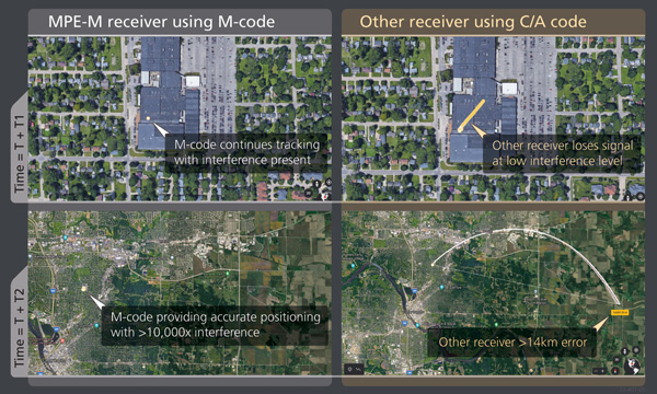
    In May, GAO issued the report “GPS Modernization: Better Information and Detailed Test Plans Needed for Timely Fielding of Military User Equipment.” about the implementation of M-code — the military-only, stronger, more jam-resistant signal.

    The report pointed out that M-code has been in development for 20+ years, and that GPS satellites have been capable of transmitting M-code signals since 2005. Also, while there are still program risks, the Next Generation Ground Control Segment, known as OCX, is forecast to be ready to support M-code use by 2023.

    OCX has experienced severe cost overruns and is more than five years behind its original schedule. GAO issued a report on OCX delays in May 2019.

    M-code won’t really be a capability in DOD, though, until user equipment is widely fielded. That will take several more years, according to GAO.

    One of the remaining challenges to M-code implementation, GAO said, was that the department did not collect and validate all the data it needed for leadership planning and prioritization.

    GPS Alternatives

    The first week of August saw release of the GAO report “GPS Alternatives: DOD Is Developing Navigation Systems But Is Not Measuring Overall Progress.”

    A summary on the first page of the report contains what could be seen as harsh criticism of how PNT efforts are led within DOD:

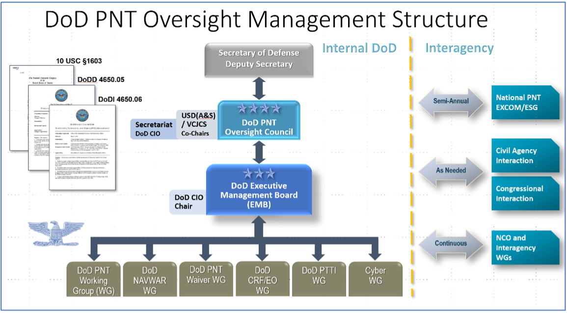
    “DOD’s overall PNT portfolio is managed by the PNT Oversight Council, a statutorily established senior-level body. However, the Council has largely prioritized modernizing the existing GPS system over alternative PNT efforts during recent meetings and has no strategic objectives or metrics to measure progress on the alternative efforts.”

    Image: DOD
    Image: DOD

    Too Much Leadership?

    Some believe the real problem with DOD PNT is not a lack of leadership, but rather too much.

    “If everyone is in charge, no one is,” commented one retired senior military officer familiar with the issue.

    “Congress has been concerned about DOD’s lack of attention to GPS and PNT alternatives for years,” the individual said. “In 2015 Congress mandated creation of the Oversight Council to help ensure PNT got the right amount of leadership attention.” This may have not had the desired effect, though.

    “The council is comprised of three undersecretaries, the vice chairman [of the Joint Chiefs of Staff], four combatant commanders, the NSA [National Security Agency] director, DOD’s CIO [chief information officer], and host of other very senior folks. All of whom have way too many other duties. It’s no wonder the department has a hard time getting things done!”

    The department’s CIO is the Defense Secretary’s Principal Staff Assistant for PNT. As such, the CIO is tasked with coordinating department-wide efforts. The task is made particularly difficult by the many and diverse players across the department, all of whom have their own authorities, interests and projects.

    Proposed systems and capabilities are examined and developed by a variety of DOD organizations. These include laboratories belonging to the five services and the Defense Advanced Research Projects Agency (DARPA).

    Programs of Record, which usually lead to acquisition of large systems, are led and managed within the individual services.

    A Better Way?

    Aside from recommending improved coordination of PNT efforts across the department, GAO has never addressed the way DOD manages its PNT enterprise.

    “That is not something we normally get into unless specifically tasked,” said one of the reports’ authors. “We assume departments know best how to lead and manage their efforts.”

    Others are not so reticent. They believe the current management structure is incapable of managing the development, acquisition and fielding of the DOD PNT Enterprise with any urgency or efficiency.

    “GAO’s focus on the Oversight Council is misplaced,” one retired official asserted. “The missing piece is not oversight, it’s day-to-day DOD-wide management.”

    “They need a multi-service program of record for resilient PNT,” the official said. “This would be separate from the GPS program, which would keep its own projects going and feed into the resilient effort. The new resilient PNT program should be managed by a Joint Program Office, which could consolidate integration and acquisition of resilient PNT applications. The office would be the steward for the critical technologies that underpin the modular, open-system integration strategy, including the digital reference architecture, input and output standards, software fusion engines, and needed modeling and simulation tools to ensure NAVWAR compliance.”

    Such a construct could provide needed focus and coordination to DOD efforts, address many long-standing congressional concerns, and, by coordinating efforts within DOD and with industry, accelerate progress.

    Related article: Who Runs GPS? 


    Dana A. Goward is President of the Resilient Navigation and Timing Foundation. He serves on the President’s National Space-based Positioning, Navigation, and Timing Advisory Board.

  • DroneShield delivers handheld counter-UAS solutions to U.S. government

    DroneShield delivers handheld counter-UAS solutions to U.S. government

    DroneShield's RfPatrol MKII bodyworn system antennas. (Photo: DroneShield)
    DroneShield’s RfPatrol MKII body-worn system antennas. (Photo: DroneShield)

    DroneShield has received and delivered upon a follow-on order by a U.S. government agency for the company’s portable and handheld counter-UAS (C-UAS) solutions.

    DroneShield is the maker of the counter-drone or anti-drone systems including RfPatrol and DroneGun MkIII. It has received contracts from the U.S. departments of Defense and Homeland Security, as well as other federal and state law enforcement agencies.

    “We’re grateful for the continued trust that this organization has placed in us to help address a unique set of operational challenges. Our customer relationships are what fuel our commitment to push the boundaries of what’s possible in the counter unmanned space,” said Tom Branstetter, director of business development, DroneShield. “Every teammate at DroneShield understands the significance of the problems we’re solving for our end-users and it’s something we’re proud to support.”

    DroneShield also recently announced deployments of its solutions for high-profile events including the World Economic Forum (WEF) in Davos, Switzerland, and IRONMAN Texas 2022.

  • The transition to M-code begins

    The transition to M-code begins

    BAE Systems has produced more than one and a half million military GPS receivers. The company is transitioning receiver designs to use the modernized military code (M-code) signal for added resiliency in RF-challenged environments. We asked Luke Bishop, director and product line engineering lead for the company’s Navigation & Sensor Systems, a few questions.

    BAE Systems’ MPE-M provide the benefit of M-Code operation in a challenged RF environment. Image: BAE Systems
    BAE Systems’ MPE-M provides the benefit of M-Code operation in a challenged RF environment. Image: BAE Systems

    Why transition to M-code?

    There are three key reasons for users to transition to M-code as supported by Military GPS User Equipment (MGUE). First, MGUE provide U.S. forces and our allies with enhanced PNT capabilities while improving resistance to threats, such as accidental and intentional jamming. Compared to the current P(Y)-code signal specs, M-code signals are stronger. Second, MGUE provides improved resistance to spoofing. Third, MGUE is field programmable, enabling updates to accommodate future enhancements to the GPS enterprise, such as regional military protection (RMP).

    Which user equipment is transitioning to M-code?

    Successful MGUE Inc 1 prototype development is being leveraged into a full portfolio of weapons, ground and aviation/maritime M-code GPS receivers. Our first production M-code receiver, MPE-M, achieved production deliveries in CY2021, with more than 1,000 delivered. Additional M-code GPS form factors are under development.

    We are also underway with the Foreign Military Sales (FMS) M-code program with MPE-M.

    How is the transition to M-code proceeding?

    As indicated by the January 2021 GAO report (GAO-21-145), M-code-capable user equipment is in the initial stages of Department of Defense (DOD) fielding for select weapon systems. Also noted by the GAO report, the DOD has conducted bulk purchases of the Increment 1 ASICs [application-specific integrated circuits] to ensure that “sufficient supplies of [them] are on hand for future integration into M-code card …based on estimated need through 2028.” We are at the beginning of M-code (MGUE). Time and the market will tell what ultimately happens.

    Which of your receivers operate with an anti-jam (AJ) antenna?

    BAE Systems’ receivers support both stand-alone AJ and integrated AJ. Receivers with integrated AJ include the NavFire-M, NavStorm-M and SABR-M receivers supporting high-dynamic weapons applications. Receivers directly supporting external AJ via a digital beamforming interface include the MPE-M and AMR. Our external AJ DIGAR offering provides exceptional performance for many stakeholders.

    Do you use advanced signal simulation equipment?

    We integrate Spirent Federal and other signal simulators in both our test and development environments, where modeled RF signals are coordinated with other sensor measurements and host vehicle messages for high-fidelity hardware-in-the-loop test cases. Our engineers create hundreds of test cases and scripted test procedures to exercise our products under all required conditions. These simulations allow us to run thousands of trials to qualify and validate performance of our products in extreme scenarios.

    Photo:
    BAE Systems’ hardware-in-the-loop simulation environments build upon Spirent Federal signal generators to test products under extreme dynamic and threat environments. (Photo: Spirent Federal)
  • 90 groups mark 2-year Ligado Order anniversary with new letter

    90 groups mark 2-year Ligado Order anniversary with new letter

    A new letter has been sent to both President Biden and congressional leadership by 90 groups opposed to Ligado’s plans to launch a terrestrial network in the L-band used by GPS.

    The letter, dated April 25, marked the two-year anniversary of a controversial decision by the U.S. Federal Communications Commission (FCC) to adopt the Ligado Order.

    The 90 groups represent companies, organizations and associations united in their grave concerns over “imminent — but preventable — harm from Ligado’s proposed terrestrial network.” These groups have serious concerns about how Ligado’s plan threatens to interfere with services provided by the GNSS, aviation and real-time environmental satellite-data communities.

    Staying the order is necessitated by the clear bipartisan will of Congress. After adoption of the order in 2020, Congress mandated an independent technical review to further assess the harmful interference that would be caused by Ligado’s proposed network and required the Department of Defense to brief federal representatives across the government “at the highest level of classification” on the potential for widespread harm from Ligado’s proposed terrestrial operations.

    On this basis alone, the FCC should stay the order to adequately consider the material new information that will be uncovered as a result of these ongoing Congressionally mandated processes, according to the letter writers.

    Their concern was made even more real following the announcement by Ligado that the company intends “to commence operations in the 1526-1536 MHz band on or after Sept. 30, 2022.”

    Image: A-Digit/DigitalVision Vectors/Getty Images
    Image: A-Digit/DigitalVision Vectors/Getty Images
  • DOD tasks Orbital Insight to help identify intentional GNSS disruptions

    DOD tasks Orbital Insight to help identify intentional GNSS disruptions

    A new platform will detect and characterize GNSS spoofing operations using artificial intelligence and commercially available data

    Geospatial intelligence company Orbital Insight has been awarded a contract from the U.S. Department of Defense (DoD) to deliver a technology platform for identifying intentional GNSS interference and manipulation operations across the world.

    The platform will leverage commercially available data to detect GNSS spoofing, where falsified or manipulated GNSS signals are used to confuse adversaries or obscure illicit activities, presenting risk to both government and commercial operations. Orbital Insight was selected through DoD’s Defense Innovation Unit (DIU) solicitation process seeking commercial solutions to counter the growing threat of GNSS disruptions to national security.


    Research suggests that Russia conducted nearly 10,000 spoofing operations from 2016 to 2018 alone.


    The new technology will significantly improve situational awareness for warfighters, intelligence analysts and safety-of-life applications. Orbital Insight’s platform will leverage its multisensor data stack, artificial intelligence and machine-learning capabilities to alert analysts and operators to potential jamming and spoofing events, techniques commonly used by adversarial actors to cover up activities or sabotage operations.

    The platform leverages a suite of geolocation data — satellites, AIS, ADS-B and internet-of-things devices — along with new advanced algorithms designed to automatically recognize anomalies linked to spoofing, complemented by research intelligence from the nonprofit partner Center for Advanced Defense Studies. Research suggests that Russia conducted nearly 10,000 spoofing operations from 2016 to 2018 alone.

    “Helping organizations understand what’s happening on and to the Earth is at the heart of what Orbital Insight does, and spoofing is a national security problem that has proven challenging to solve,” said Kevin O’Brien, CEO, Orbital Insight. “GNSS spoofing is essentially a data problem, and Orbital Insight’s AI and deep data stack can help identify spoofing, along with other major humanitarian and environmental challenges. This is a perfect example of private and public sectors uniting through technology.”


    Other areas that may be addressed: identifying drug trafficking, illegal fishing, sea-borne piracy and unintentional commercial aviation disruptions


    The technology has broad implications that extend beyond situational awareness of intentional GNSS interference. Other national security, humanitarian and environmental challenges may be addressed, such as identifying drug trafficking, illegal fishing, sea-borne piracy and unintentional commercial aviation disruptions.

    Federal agencies are increasingly complementing their systems with commercial technology and data sources that are unclassified, universally accessible, and shareable with allies. The National Air and Space Intelligence Center will be the first customer to utilize the technology. Upon successful integration, the goal will be to expand this platform widely across the defense, intelligence and civil communities.

    Orbital Insight received the DoD contract on the heels of announcing a Phase II Small Business Innovation Research contract from the National Geospatial-Intelligence Agency to deliver a computer-vision model that uses synthetic data to detect novel classes of objects.

    The company also recently launched a new class of multiclass object-detection algorithms within its flagship GO platform to help the intelligence community monitor and differentiate activity at thousands of areas of interest. Like all of Orbital Insight’s products, these algorithms are being developed within an ethics framework that shapes the company’s work and values privacy.

    Image: matejmo/iStock/Getty Images Plus/Getty Images
    Image: matejmo/iStock/Getty Images Plus/Getty Images
  • Geotab wins contract for fleet telematics in U.S. Air Force vehicles

    Geotab wins contract for fleet telematics in U.S. Air Force vehicles

    U.S. Air Force Airmen repair government-operated general-purpose vehicles at Moody Air Force Base, Georgia. (Photo: U.S. Air Force/Airman 1st Class Lauren M. Johnson)
    U.S. Air Force Airmen repair government-operated general-purpose vehicles at Moody Air Force Base, Georgia. (Photo: U.S. Air Force/Airman 1st Class Lauren M. Johnson)

    The U.S. Air Force will equip its 21,000 general-purpose vehicles with Geotab fleet-management technology after the company was awarded a sole-source contract.

    Geotab received FIPS 140-2 validation for its cryptographic library in February 2019 as well as FedRAMP authorization and ISO 27001 certification for its telematics platform. These compliance certifications and authorizations validate Geotab’s system and organizational processes, enabling the company to offer its fleet-management services to all levels of federal, state and local government agencies.

    Geotab’s fleet-management technology for the Air Force is secure and customized. It includes the following features to help the service more effectively manage its vehicles:

    • automated odometer capturing
    • engine diagnostics
    • problem predictive analytics
    • fuel data
    • custom reporting
    • GHG reduction dashboards
    • fleet right-sizing reporting

    Selected for its integration capacity and proven commitment to information security, the sole-source award from the Department of the Air Force yields an Authorization to Operate (ATO) within the Department of Defense (DoD). The authorization will allow other DoD agencies to leverage Geotab services by piggybacking off of this DAF ATO.

    Geotab fleet-management products are used by more than 2,000 government agencies and departments at all levels to capture, measure and analyze crucial fleet data with deep granularity. “Winning this sole-source contract from the Department of the Air Force further solidifies Geotab’s ability to collaborate with agencies that operate at the highest levels of national data security and to provide a customized and highly secured telematics solution,” said Dan Zdarko, business development manager, federal government, Geotab.

    “It is vitally important that the technology we deploy in our fleets meet the highest standards of data security put forth by the U.S. government,” said Tim Patterson, program management flight chief from the U.S. Air Force’s 441st Vehicle Support Chain Operations Squadron at Langley Air Force Base in Virginia. “Our objective is to enhance fleet-management strategies and reduce the total cost of ownership longer term across the Department of the Air Force.”

  • US Army selects Orolia Defense & Security as winner in XTech Plugfest

    US Army selects Orolia Defense & Security as winner in XTech Plugfest

    Company prevails in military’s pursuit of CMOSS PNT solutions

    Recognized for its outstanding technology achievements and the potential for impact to the United States Army and Department of Defense (DOD), Orolia Defense & Security was selected by a panel of judges as a finalist during the 2021 xTech Plugfest competition.

    Hosted by PEO IEW&S, PM-PNT, the event allowed industry participants to demonstrate C5ISR/EW Modular Open Suite of Standards (CMOSS) capabilities via PNT cards, switch cards and chassis.

    The event took place at the Open Innovation Laboratory (OIL) on Aberdeen Proving Grounds, Maryland, Nov. 8-19, 2021.

    Photo: Orolia
    Photo: Orolia

    CMOSS prescribes criteria for integrators that reduce the size, weight, and power (SWaP) of C5ISR and EW systems while increasing their flexibility and adaptability by enabling the sharing of hardware and software components.

    Orolia submitted a CMOSS timing card and was formally recognized as a top five winner at OIL’s open house (with 200+ attendees) for demonstrating its capabilities and commitment to supporting the U.S. Army and DOD in pursuit of CMOSS PNT solutions.

    “I am extremely proud of our team for their efforts and sharp-wittedness in developing and presenting this technology at an accelerated level,” said Conrad Meyer, director of business development at Orolia Defense & Security. “We are honored to have taken part in this event and to be distinguished among many contenders.”

    Orolia’s prototype has a plug-and-play architecture powered by its FlexFusion engine, with additional capability for jamming and spoofing detection via its patented BroadShield software. It is designed for easy in-field upgradability.

    Orolia plans this year to release a commercially available, fully compliant CMOSS/SOSA PNT card for use in military air and ground-mounted systems.

  • Boeing awarded contract to support GPS Block IIF operations

    Boeing awarded contract to support GPS Block IIF operations

    Artist's rendering of GPS IIF satellite. (Image: U.S. Air Force )
    Artist’s rendering of GPS IIF satellite. (Image: U.S. Air Force )

    Boeing has secured a 10-year, $329.3 million contract to help the U.S. Space Force engineer operational GPS Block IIF satellites, the Department of Defense announced Dec. 20.

    The company will perform engineering work to support on-orbit operations of the Block IIF satellites, which were manufactured by Boeing.

    Space Systems Command issued the indefinite-delivery/indefinite-quantity contract to address GPS IIF mission requirements across the military and expects work to conclude by Dec. 20, 2031.

    The U.S. Air Force deployed the first Boeing-built IIF satellite in May 2010 and launched the 12th and final satellite in February 2016.

  • BAE Systems awarded a $316M contract to deliver military GPS modules

    BAE Systems awarded a $316M contract to deliver military GPS modules

    Image: BAE Systems
    Image: BAE Systems

    The U.S. Defense Logistics Agency has executed a $316 million contract option for BAE Systems’ advanced M-code GPS modules, raising the contract funding to $641 million.

    The modules provide dependable positioning, navigation, and timing for ground troops, vehicles, aircraft and precision munitions. The contract will ensure the availability of Common GPS Modules (CGM) for advanced military GPS receivers with anti-jamming and anti-spoofing capabilities that enable operation in contested environments.

    Under the contract option executed in November, BAE Systems will manufacture CGMs for future ground, airborne and weapon GPS receivers for the U.S. Department of Defense (DoD) and its allies. The award builds on a May $325 million contract and enables BAE Systems to continue to meet domestic and international demand for Military GPS User Equipment (MGUE) Increment 1 M-Code modules in GPS receivers through the end of the decade.

    “Military operations require assured positioning, navigation and timing, and our customers are shifting to M-code to harden their GPS receivers against jamming and spoofing,” said Frank Zane, Navigation and Sensor Systems business development director at BAE Systems. “We’re ready to meet this need today with secure, reliable M-code GPS solutions, and we’re developing the next-generation of solutions to stay ahead of the threat.”

    BAE Systems is delivering two advanced M-code GPS receivers: the Miniature Precision Lightweight GPS Receiver Engine – M-Code and the NavStrike-M GPS receiver.

    Deliveries of the ultra-small MicroGRAM-M are expected in 2022, and deliveries of the Strategic Anti-jam Beamforming Receiver – M-Code are expected in 2024.

  • GSA selects Hexagon US Federal as prime for ASTRO contract

    GSA selects Hexagon US Federal as prime for ASTRO contract

    GSA logoThe U.S. General Services Administration (GSA) has selected Hexagon US Federal as a prime contractor for ASTRO, a 10-year, indefinite-delivery/indefinite-quantity (IDIQ) contract with an estimated $90 billion value.

    The ASTRO contract is being administered by the Federal Systems Integration and Management Center (FEDSIM). Sponsored by the Department of Defense (DoD), ASTRO is comprised of 10 pools to deliver services related to manned, unmanned and optionally manned platforms and robotics.

    Hexagon was selected as one of multiple awardees for the Data Operations Pool, which includes all data collection, processing, exploitation, and dissemination activities associated with manned, unmanned, and optionally manned platforms and/or robotics supporting mission performance. The formal government kick-off is anticipated to take place in November 2021.

    Hexagon is a provider of digital reality solutions, combining sensor, software, and autonomous technologies, putting data to work to boost efficiency, productivity, quality and safety across industrial, manufacturing, infrastructure, public sector and mobility applications.

    Hexagon US Federal provides technology and professional services for C5ISR, installation security, GIS, and cyber security. Dedicated to the delivery of Hexagon technology and services to the U.S. government, including defense, intelligence, and civilian organizations, the company builds solutions that help its customers design, build, maintain, manage, operate, and protect.

  • US Defense Department looking for GNSS disruption detection and analysis

    US Defense Department looking for GNSS disruption detection and analysis

    The U.S. Department of Defense wants help making sense of commercially and publicly available information that could be used to detect GNSS disruptors, especially over large areas.

    Obtaining the ability to detect and geolocate GNSS disruptions has been cited as an unmet need in a number of U.S. national policies and plans dealing with positioning, navigation and timing.

    The recently posted solicitation calls the project “HARMONIOUS ROOK – Situational Awareness for Intentional Disruption of Global Navigation Satellite System (GNSS) Users.” The solicitation says:

    “The Department of Defense (DoD) seeks commercial solutions leveraging machine-driven analytics and datasets derived from publicly/commercially available information (PAI/CAI) to provide a situational awareness capability for intentional global navigation satellite system (GNSS) disruptions. This solicitation is particularly focused on persistent, large-area coverage of falsified GNSS emitters that result in localized spoofing phenomenology.”

    Studies and analyses by non-profit organizations and commercial entities have demonstrated the ability of non-governmental organizations to do this kind of work and produce remarkable results. In 2017, our Resilient Navigation and Timing Foundation detected and reported on widespread GPS spoofing in the Black Sea.

    Another non-profit, C4ADS, built upon our work and produced a detailed 2019 report on GPS spoofing in Russia and Syria. In 2019 and 2020, the environmentally oriented non-profit SkyTruth reported on circle spoofing in China and around the globe. In July, SkyTruth revealed warship activities being misreported in Automatic Identification System databases.

    This acquisition is being led by the Defense Innovation Unit, or DIU. The unit was specifically created to accelerate the adoption of commercial technology and services by the defense and national security establishments. While letting a traditional DoD contract for a prototype can often take up to 18 months, DIU aims to award contracts within 60 to 90 days of identifying the problem.

    To do this, DIU uses the government’s “commercial solutions opening” process, which is designed to be simple and quick.

    Companies who provide analytic services and those who have unique data sets are both encouraged to apply. The deadline is August 23.


    Dana A. Goward is president of the Resilient Navigation and Timing Foundation

    An Interim Armored Vehicle "Stryker" and AH-64 Apache helicopters with Battle Group Poland move to secure an area during a lethality demonstration as part of Saber Strike 18 in June 2018. (Photo: U.S. Army/Spc. Hubert D. Delany III, 22nd Mobile Public Affairs Detachment)
    An Interim Armored Vehicle “Stryker” and AH-64 Apache helicopters with Battle Group Poland move to secure an area during a lethality demonstration as part of Saber Strike 18 in June 2018. (Photo: U.S. Army/Spc. Hubert D. Delany III, 22nd Mobile Public Affairs Detachment)
  • Defense Innovation Unit seeks GNSS interference solutions

    Defense Innovation Unit seeks GNSS interference solutions

    A surveillance system is demonstrated during a Naval Information Warfare Systems Command (NAVWAR). (Photo: Rick Naystatt/U.S. Navy)
    A surveillance system is demonstrated during a Naval Information Warfare Systems Command (NAVWAR) exercise. (Photo: Rick Naystatt/U.S. Navy)

    The U.S. Defense Innovation Unit (DIU) is asking for commercial solutions to fight GNSS disruptions, including jamming and spoofing.

    DIU is particularly asking for “solutions leveraging machine-driven analytics and datasets derived from publicly/commercially available information to provide a situational awareness capability” against intentional disruptions.

    Responses to “HARMONIOUS ROOK — Situational Awareness for Intentional Disruption of Global Navigation Satellite System (GNSS) Users” are due by Aug. 22.

    DIU is a Department of Defense organization focused exclusively on fielding and scaling commercial technology across the U.S. military to help solve critical problems.

    The solicitation is focused on “persistent, large-area coverage of falsified GNSS emitters that result in localized spoofing phenomenology.”

    It cites intentional manipulation of GNSS signals as enabling “nefarious activities, to include narcotics trafficking, unapproved operation of autonomous vehicles, illegal fishing and sea-borne piracy.”

    “Additionally, nation-state use of GNSS jamming or spoofing systems may extend beyond the area of conflict, causing deleterious effects on civilian populations,” the solicitation states. “Such activities degrade or deny critical geolocation capabilities and further introduce hazards to safety-of-life-navigation, critical infrastructure, and emergency response services. “