New GPS ground stations that are contracted by Raytheon Technologies to replace the current ground stations have been delayed until July 2025, the Pentagon’s testing office reported.
The Next Generation Operational Control System (OCX) is facing a new delay of 16 months, according to the 2023 Annual Report of the Director of Operational Test & Evaluation (DOT&E).
More than seven years behind schedule, the continuous delays have caused the U.S. Department of Defense (DOD) to go over its yearly budget and have sparked discussions as to future budget allocations for the U.S. Space Force (USSF) to continue to control and enhance the GPS constellation.
“These delays increase the risk that U.S. and allied warfighters will be unable to conduct successful operations in future contested environments due to the lack of access to modernized GPS position, navigation, and timing (PNT) information,” the Pentagon’s testing office said in a statement.
The M-Code can now be broadcast on 21 of the 31 GPS satellites in orbit. However, it is only available to a small number of military personnel due to both the OCX issue and a lack of radios and receivers equipped to access it.
The Space Force has a Military GPS User Equipment (MGUE) program underway to develop new computer chip-carrying cards to retrofit existing platforms, such as aircraft and ships, so they can ingest M-code signals, as well as to develop a new handheld receiver. This effort has also experienced delays, according to a June 2023 report by the Government Accountability Office.
The 2024 DOT&E report notes that because of the delays in the development of the MGUE receiver cards, the Army and Marine Corps are now buying commercially developed receivers capable of ingesting the M-Code for fielding with ground vehicles.
Additionally, the DOT&E report cautions that because the OCX software is designed to be the basis for an upgraded system, OCX Block 3F, designed to control the planned next generation of GPS satellites called GPS IIIF, that effort also is likely to be delayed. The Space Force intends to launch the first GPS IIIF satellite in 2027.
The Department of Defense (DOD) shoulders an enormous responsibility, perhaps one whose significance the world does not fully grasp: the sheer number of military, civil and commercial users, each with hundreds of unique use cases, that depend on the Global Positioning System (GPS).
No other DOD-operated system serves such a diverse array of users and interests. From Special Operators to ship and tank drivers, pilots and operators, the military user base is expansive. Civil users include first responders, general aviators, and those supporting the international flying public, whose numbers are again setting records. Additionally, countless average people like you and me just “use it” in our daily lives without considering how it works. The ever-expanding commercial market consists of $1.7 trillion in 2023 dollars in economic benefits accruing to the U.S. economy alone, millions of jobs, and fierce global competition to produce the “best of the best” of the 6.5 billion user receivers in operation today.
With these users and interests in mind, what does that mean for GPS’ future? It raises more questions than answers — about policy, governance, program execution and threats that urgently need to be addressed:
What indicators will determine whether the United States has met its policy goal to be the global leader in “service provision and the responsible use of global satellite navigation systems, including GPS and foreign systems?”
Building on this publication’s previous articles, what constitutes a “Gold Standard” in 2024? Which users determine this definition? How and when do foreign global navigation satellite systems’ capabilities factor into this definition?
What funding levels ensure the security, accuracy, availability and resilience of GPS? In Fiscal Year 2022, Congress provided more than $2 billion for DOD to procure and conduct research and development on GPS III and IIIF satellites, procure military user equipment, and upgrade the ground architecture. In 2022, the Department of Transportation received $22 million for GPS resiliency and $92 million for the Wide Area Augmentation System. Is this level of funding sufficient to bring innovative technologies to GPS?
Speaking of innovation, U.S. law directs DOD to “sustain and operate” GPS for military and civilian purposes. How can innovative GPS technologies contribute to “sustain and operate” missions?
Who should participate in decisions regarding the timing of GPS upgrades and satellite launches?
Where does the most accurate data on cyber and other threats to GPS satellites, ground stations, military and civil user equipment, and commercial receivers reside? Who evaluates that data to determine the overall risks to GPS? Should those risks be shared with all users? How quickly will the most severe risks be mitigated?
Do the Federal Communications Commission, the Department of Homeland Security, and the Department of State have sufficient resources to detect and prosecute illegal and irresponsible spoofing and jamming incidents in the United States and overseas?
What is the earliest date the much-anticipated L1C, L2C, and L5 signals can be operational?
The GPS Innovation Alliance (GPSIA) believes the U.S. government does not have to shoulder such difficult and urgent questions alone. GPSIA looks forward to sharing insights while working with government agencies and the wider user community to answer these questions and put in place executable plans to address these challenges.
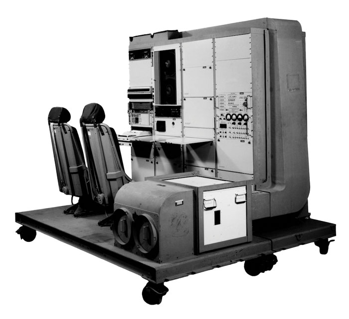
1976: The first military GPS five-channel receiver built in one of several programs that studied the feasibility of GPS. The receiver weighed more than 270 pounds and had seats for two operators. (Image: Rockwell Collins/Smithsonian)
Half a century ago, on December 22, 1973, Deputy Secretary of Defense William P. Clements, on the recommendation of the Defense Systems Acquisition and Review Council, directed the entire Department of Defense — through the Navstar GPS Joint Program Office, under the spectacular leadership of Col. Bradford Parkinson — to proceed with the GPS program. While this magazine mostly focuses on the present and the future, we occasionally pause to remember how it all began.
In the following articles, we are lucky to benefit from the long memories of four gentlemen who were there. Read the full articles.
Fifty years since it was designed and approved by the U.S. Department of Defense (DOD), the GPS is at risk of losing its status as the world’s gold-standard location service, reported The Wall Street Journal.
In a recent paper published by Harvard’s Belfer Center for Science and International Affairs, “China’s BeiDou: New Dimensions of Great Power Competition,” Sarah Sewall, executive vice president for strategic issues at IQT and co-authors Tyler Vandenburg and Kaj Malden outline their finding that China’s version of GPS is part of the country’s longstanding effort to join the technological ranks of leading nations and use its capabilities to achieve geopolitical advantage across the globe.
Sewall’s assessment of BeiDou’s technical superiority received some unexpected support from a government advisory board on GPS, which stated that “GPS’s capabilities are now substantially inferior to those of China’s BeiDou,” and urged the administration to regain U.S. leadership in the field.
The BeiDou constellation is newer and has more satellites than any other system and has more than ten times as many monitoring stations around the world than GPS does. As a result, BeiDou’s accuracy is much better in many places, including the developing world.
Sewall points out that in cases where BeiDou provides the most accurate positioning, navigation, and timing (PNT) data, particularly in the global south, China may be able to influence other nations’ economies, stating that it is one example of “a new form of great power competition that most in the U.S. government don’t recognize.” China is providing superior PNT information to enhance its diplomatic, economic and military power and the United States cannot afford to cede this area of longstanding advantage.
BeiDou being newer and more advanced than other GNSS, makes it easier for China to encourage other nations to use its signals and purchase specialized equipment, especially when equipment purchases are heavily subsidized by the Chinese government, harming the U.S. economy and its status as the leader of GNSS technology.
Recent launch and surveillance fears
On May 16, 2023, China launched its most recent BeiDou satellite to replenish the constellation, bringing its total to 56 satellites, nearly twice as many as the 31 GPS satellites.
The latest BeiDou satellites also feature two-way messaging, a feature that GPS does not have. It is mainly available in China and requires special chips that are not widely available in the consumer market. It enables users to send short messages in areas without ground network cell coverage and can be used for search and rescue operations.
The CNBC report noted the fear that, with its most recent enhancements, the BeiDou system could be used as a surveillance device — as the two-way messaging feature reveals a user’s locations as well as other types of data.
Additionally, with the growing number of applications for cellphones and an increase in autonomous vehicles that use the BeiDou system, more and more user data is being transmitted.
The U.S. military is upgrading GPS with more-modern satellites that are designed to give nonmilitary devices more-precise coordinates in more indoor and hard-to-reach spaces. However, the next-generation GPS service for civilians is not expected to be released for several years.
GPS pioneered the PNT industry by offering civilians a new, free-to-use system. While originally developed for DOD, it turned into a critical global infrastructure that underlies a vast swath of the U.S. economy.
Besides GPS and BeiDou, there are two other global navigation satellite systems (GNSS), Russia’s Glonass and the European Union’s Galileo, as well as regional systems from Japan (QZSS) and India (NavIc).
BeiDou, once a small regional network with clunky receivers and few civilian users, has grown significantly since launching its first two satellites in 2000. It now has more than 30 precision-enhancing monitoring stations and claims to pinpoint users’ locations to within several centimeters, along with offering basic two-way communication capabilities.
Both BeiDou and GPS offer a variety of nonmilitary benefits that expand beyond the systems’ original expectations, from Uber drivers who often rely on a smartphones GNSS data to locate customers to farmers who can use GPS-based applications for farm planning, field mapping, solid sampling and more. GPS has been called “the silent utility” because signals are used in almost every technology, said Dana Goward, president of the Resilient Navigation and Timing Foundation.
Looking forward
GPS guides U.S. missiles, ships and troops through more-secure military frequencies kept separate from its civilian signals. Its past dominance even made rival militaries reliant on the Pentagon-controlled system.
The U.S. military has long planned to upgrade GPS with a fleet of modernized and upgradable satellites that provide more-precise coordinates subject to less interference. The newer satellites broadcast data to civilian users over a new frequency called L5.
The Space Force has 17 L5-equipped satellites in orbit after a series of delays but has yet to reach the 24 live satellites needed to run a reliable system. Some already-built satellites sit in a Colorado warehouse awaiting their turn for a funded launch.
The Space Force said in a statement that GPS continues to set the gold standard in its field.
“While other nations may report improvements in accuracy and equivalent performance in availability, GPS is still the clear leader in integrity and is the only system accepted for international flight use,” a spokeswoman for the branch’s Space Systems Command told The Wall Street Journal.
This year marks 50 years since the U.S. Department of Defense approved the design for GPS and first funded the program. It is also the 30-year anniversary of an important milestone – initial operational capability of GPS. Please don’t let its longevity fool you into thinking it is past its prime! GPS is, and will remain, one of the most innovative systems ever designed, funded and operated by the U.S. government.
Today, GPS represents a highly successful public and private partnership, one in which diverse stakeholders continue to coordinate through fora such as the National Executive Committee for PNT and its Advisory Board. and the Civil GPS Service Interface Committee. How did this system become a military, public safety, critical infrastructure, and economic success? The world-class GPS community is made up of the teams and individuals who design, develop and operate these critical technologies as well as the people and organizations that benefit from its applications. From pioneers, scientists, engineers, and Guardians to civil servants, lawmakers, and entrepreneurs, the GPS community has transformed, is transforming, and will continue to transform lives across the globe, and soon, the moon.
GPS World highlighted the important roles played by many early GPS pioneers in a two-part series aptly titled, “Heroes” in the May and June 2010 issues. It has also covered Dr. Gladys West, who is one of the most consequential mathematicians and programmers to contribute to the global success of GPS. Her geodetic models helped refine our understanding of Earth’s shape, which proved fundamental to the success of GPS and its myriad applications. In 2021, the Trimble Foundation established the Dr. Gladys West Scholarship Program. Virginia State University (her alma mater!), North Carolina A&T State University, and Florida International University award four-year scholarships to one student per year to honor Dr. West’s achievements as a woman of science and a woman of color.
A celebration of GPS must also recognize our lawmakers — the people who authorize and appropriate funding for GPS and its augmentation programs. Nearly every U.S. federal department and agency uses these systems to fulfill their missions on behalf of the American people. They also leverage their technical, programmatic, operational, and experiential expertise to ensure that GPS and its augmentation systems remain the best in the world. This work is possible thanks to congressional committees, members of Congress, and staff. The Senate Appropriations and House Appropriations committees, the Senate Armed Services and House Armed Services committees, the Senate Commerce, Science and Transportation and the House Energy and Commerce committees, the GPS Caucus and many more members of Congress, provide critical oversight and funding. Their support ensures that GPS continues to bring $1.7 trillion and counting in economic benefits to the U.S. economy, creating hundreds of thousands of jobs while enhancing national security, public safety and critical infrastructure.
The future is bright for GPS manufacturers and those developing new applications. To realize their success, projects funded by the Infrastructure and Investment Jobs Act and the Inflation Reduction Act will depend on GPS to continue to deliver signals that are accurate, have integrity, and are available and continuous in nature. The next enterprising GPS entrepreneur is waiting in the wings
Thanks to a network of determined individuals, GPS-driven technologies — used to support precision agriculture, safe transportation, synchronized global banking, cutting-edge emergency response, elite and amateur sports, and more — are transforming our lives, creating jobs, and promoting growth across the economy.
GPSIA joins other members of the GPS community by celebrating 50 years of GPS and looks forward to the innovations and applications that will shape the next 50 years and beyond.
Image: Navy Petty Officer 1st Class Devin M. Langer
The U.S. Department of Defense has called for thousands of UAVs to be built as a part of its Replicator initiative that aims to hasten military innovation to “leverage platforms that are small, smart, cheap and many,” said Deputy Defense Secretary Kathleen Hicks in a recent speech. This was cited in a Wall Street Journal editorial published on Sept. 13.
The United States plans to build thousands of UAVs over a 24-month period to counter China and the current military threat against U.S. forces in the Pacific Ocean. The UAV swarms could help the United States jam or distract enemy radars and surface-to-air missiles to stop China from pushing U.S. forces out of the Pacific.
The Wall Street Journal article stated that this idea by the Pentagon is not a real substitute for a bigger navy. While the Pentagon’s idea of UAV swarms for reconnaissance in the Pacific is technologically innovative, the article stated that the United States will still need technology breakthroughs and plentiful stocks of materials ranging from aircraft to munitions.
Furthermore, Deputy Hicks said that the Replicator initiative is not asking for new money in the next fiscal year budget, citing “not all problems need new money; we are problem-solvers, and we intend to self-solve,” reported the Wall Street Journal.
A new swarm of UAVs will give significant support to the U.S. military to counter China. However, the Pentagon’s quick plan for an unmanned technological “revolution” will need more investment to compensate for the failures that will inevitably accompany the new technology, the editorial argued, and to build “two Virginia-class submarines a year and fielding thousands of long-range weapons so U.S. forces don’t run out of their best firepower after a week in the Taiwan Strait.”.
The U.S. government has visibly and physically conveyed its interest in getting air taxis into operation, through a visit of 70 people — attached to the newly formed Advanced Air Mobility (AAM) Coordination group — to Archer Aviation. The group talked with the executives of the company developing the “Midnight’ air-taxi aircraft and watched a flight test.
The AAM group includes members from leading government agencies concerned with making and keeping this segment of aviation successful, including the Federal Aviation Administration (FAA), the Department of Transportation (DOT), the National Aeronautics and Space Administration (NASA), the Department of Defense (DOD) and other agencies.
AAM group visits Archer Aviation. (Image: Archer Aviation)
Gathering the views of Archer and other electric vertical takeoff and landing (eVTOL) developer executives should be an essential part of the AAM group’s information collection task. And while it’s great to see that the interagency group has every intention of promoting the AAM concept of air taxis, it would perhaps be better if the group also had access to representatives of manufacturers, developers, and those with UAS experience. It’s clear that we need to start by spreading the word, but also by including people in the group who have dedicated themselves to bringing these capabilities to market — that may make the process more efficient.
Along the way, it may also help to understand that the processes we have used in the past to get airframes like this into passenger carrying operations might not work well with this new industry. It’s understandable that it should take a lengthy period to assess, verify, qualify and certify such vehicles in the name of safety, but if companies run out of cash and fold in the interim — which is highly likely with this “start-up industry” — then shouldn’t we be looking for a better way to get these guys off the ground?
No one wants safety to be sacrificed, but could there be some way to streamline, speed up, or simplify the process without skipping essential steps — a way to get new technology into use before it’s obsolete, or a lack of start-up money dooms its progress? The forecast for the economy in the near future is in the billions of dollars. So, providing funding to improve the current processes does make sense. DOD has started to put serious effort into speeding up its acquisition process and has empowered the Defense Innovation Unit (DIU) to find quicker ways to bring commercial technologies into defense.
The processes used to bring new technologies into use are tried and proven, but they are lengthy. In defense, if our opposition can field things quicker than we do, they have an edge in strategy, tactics and a higher probability of winning in battle. These countries are using the same approaches in the commercial world too, and we need to be wary that they may also have a greater chance of winning the “economic war.”
Nevertheless, Archer in California and others such as Joby, also in California, and Liliam in Germany, plod on through varying stages of FAA and European Union Aviation Safety Agency (EASA) certification paths. An example of the effort that a company has been required to put into fulfilling the requirements of a certification agency is that of Lilium, which first applied for its Design Organization Approval (DOA) in 2017, is still churning through the qualification efforts and does not expect approval until 2025. Of course, the answer is “Don’t get on the certification ‘hamster-wheel’ unless you can stand the journey.” However, we do want these systems and vehicles to make it in order to overcome some of the traffic nightmare that we are living through in our major cities and to contribute to the growth in the economy.
Meanwhile, the great hope (even expectation) of the “flying car” is being kept alive by Doroni in Miami with its two seat H1 eVTOL. Having largely burnt through its $3.6 million StartEngine launch money, Doroni is looking for its second round of funding to build more prototypes and join the certification race. However, other single seat eVTOL flying cars have taken the easier route to certify under the FAA Ultralight category.
Doroni H1 prototype. (Image: Doroni)
The H1 has semi-autonomous capability, which Doroni claims will make its eVTOL easy to fly, and allow general sales to any car driver. With air bags, an aerodynamic fuselage — which generates lift — 10 independent propulsion systems (four double prop ducted fans and two forward thrust props), an airframe that can behave as a parachute and “dissipate energy” in case of a crash, and landing gear, the H1 also has multiple independent batteries — all aimed at safety, which will help make it through certification verification. So, if you happen to have the $250,000 proposed sale price and are willing to wait on the completion of FAA certification, you could own your own “flying car.”
Doroni just announced that they have already made 50 test flights within their manufacturing facility along that test and qualification road.
Meanwhile, Ryse Aerotech in Ohio, recently demonstrated a manned test flight of its single seat Recon eVTOL — billed as an aid to farmers, with a top speed around 58 mph, a range of about 25 miles and with the right FAA clearance it could even reach an altitude of 700 ft — an airborne ATV for inspecting crops and the like.
Recon manned test flight in June 2023. (Image: Ryse Aerotech)
The path to market that Ryse has selected, however, should see more vehicles in earlier use than Doroni’s H1. All you may need is a driver’s license to take off in a Recon because it’s qualified as an Ultralight craft — just buy and fly. Beware, you cannot fly anywhere near an airport or after dark. FAA has restrictions on Ultralight craft.
So, progress on the semi-autonomous “flying-car” front and a plea to consider the economic benefits and to look to how to improve the efficiency of the existing certification process — not a request to cut corners, rather a request to speed up the processes and save this start-up industry before it goes broke.
The Joint Counter-Small Unmanned Aircraft Systems office successfully tested BAE Systems’ APKWS laser-guidance kits in a counter-unmanned aircraft systems (C-UAS) mission.
During the Department of Defense-led exercise at Yuma Proving Ground, Arizona, the 70 mm APKWS-guided rockets demonstrated 100% effectiveness when fired against 25-to-50-pound UAVs traveling at more than 100 miles an hour. The APKWS C-UAS solution is platform agnostic, permitting multiple options to accelerate fielding.
APKWS transforms unguided rockets into smart munitions for precision strikes on soft and lightly armored targets. An updated proximity fuse for the standard M151 warhead enables laser-guidance kits to target Class-2 and Class-3 UAVs, which typically weigh less than 55 lbs. The fuse retains the legacy point denotation capability for flexibility of the weapon in the field.
APKWS now enables rockets to engage and destroy UAVs at a fraction of the cost of existing C-UAS systems with unprecedented precision.
The kits are available to all U.S. armed forces, as well as allies via foreign military sales.
AUVSI has launched Green UAS, a program to expand the amount of commercial UAS that have been verified to meet high levels of cybersecurity and National Defense Authorization Act supply chain requirements.
Green UAS meets the Blue UAS certification program of the Defense Innovation Unit. It is designed for users who do not immediately require Department of Defense authority to operate.
Green UAS also offers a streamlined pathway to the Blue UAS 2.0 cleared list.
Green UAS is suitable for users who rely on commercial, off-the-shelf UAVs to conduct diverse operations. These users include federal government agencies, local law enforcement, first responders and state departments of transportation.
Green UAS is also suitable for industrial enterprise users such as energy and utility companies, telecoms, manufacturers, food and agriculture, and logistics and mapping/surveying companies.
Nearly 50 years ago, in December 1973, the Defense Systems Acquisition Review Council approved the Navstar Global Positioning System for entry into Phase I of development. Since then, through its development, deployment and continuing modernization, GPS has grown into a complex program. It is operated by the Department of Defense based on legislation from Congress, executive orders from the White House, and policies established jointly with the Department of Transportation. It supports U.S. military missions as well as myriad scientific, commercial and consumer applications around the planet. Of course, the last category, with its billions of users, now dwarfs all the other ones combined.
The GPS program, with an annual budget of nearly $2 billion and no user fees, is a gift from U.S. taxpayers to the world. It has staff in Washington, D.C.; at the Pentagon in Arlington, Virginia; at Schriever Space Force Base, Colorado; at the Space Systems Command at Los Angeles Air Force Base, California; at Cape Canaveral, Florida; at the U.S. Coast Guard Navigation Center in Alexandria, Virginia; and at GPS ground antennas in additional locations around the world. From the White House to Congress to aerospace companies, from military officers to civilian civil servants, from policy makers to engineers, from the East Coast to the West Coast to remote islands in the Pacific, Indian and Atlantic Oceans, GPS is a vast enterprise — most of which is little known even to people in the industry and virtually unknown to the public.
The Global Positioning System is a vast and mostly unknown enterprise. This section — the first in an occasional series of authoritative reference pieces in this magazine — aims to clarify who does what to maintain GPS as a fantastic global utility. The relevant missions of agencies or units are in italics.
After I researched and drafted the piece, I asked the experts listed below to review it and provide corrections and additions. While grateful for their substantial feedback, I take sole responsibility for any remaining errors or omissions.
Thank you to the following experts:
Harold W. Martin III, Director, Space-Based Positioning, Navigation & Timing, National Coordination Office
Michael J. Dunn, Capability Area Integrator for PNT, Space Systems Command, United States Space Force
Lt. Col. Robert O. Wray, Commander, 2nd Space Operations Squadron, United States Space Force
Scott R. Calhoun, Commanding Officer, Navigation Center, United States Coast Guard
Paul Benshoof, Technical Director, 746th Test Squadron (AFMC), Central Inertial and GPS Test Facility
Bernard Gruber, Senior Director, Northrop Grumman
Please return to this page periodically to read corrections and updates to this special section. If you spot any significant inaccuracies or omissions, please bring them to my attention by writing to me at [email protected].
The United States Department of Defense (DOD) will provide a new package of security assistance for Ukraine to aid with ongoing Russian aerial attacks. The package includes defense tools such as GPS-guided rockets and counter-UAV equipment.
The presidential drawdown package includes:
additional ammunition for High Mobility Artillery Rocket Systems
additional 155 mm artillery rounds
additional 120 mm mortar rounds
190 heavy machine guns with thermal imagery sights and associated ammunition to counter unmanned aerial systems
181 Mine Resistant Ambush Protected vehicles
250 Javelin anti-armor systems
2,000 anti-armor rockets
Claymore anti-personnel munitions
demolitions munitions
cold weather gear, helmets and other field equipment.
Under the Ukraine Security Assistance Initiative (USAI), DOD will provide Ukraine with:
two HAWK air defense firing units
anti-aircraft guns and ammunition
equipment to integrate Western air defense launchers, missiles and radars with Ukraine’s air defense systems
equipment to sustain Ukraine’s existing air defense capabilities
air defense generators
counter-unmanned aerial systems
four air surveillance radars
20 counter-mortar radars
spare parts for counter-artillery radars
Puma unmanned aerial systems
precision-guided rockets
secure communications equipment
medical supplies
funding for training, maintenance and sustainment.
Ukraine has been able to intercept Russian UAVs and missiles; however, having additional air defense will help combat efforts.
The latest chapter of the decades-long Lightsquared/Ligado saga will be revealed this week
The National Academies of Science, Engineering and Medicine (NASEM) will hold a public online briefing at 11 a.m. ET on Sept. 9 to present the results of its Ligado interference study. The committee’s report will be available at National Academies Press at that same time.
The decision by the Federal Communications Commission (FCC) to grant Ligado Networks permission to operate a terrestrial service in a frequency band adjacent to that used by GPS has been controversial since it was announced in April 2020.
The Executive Branch has formally objected to the decision because of its potential to interfere with various kinds of GPS receivers and requested its reversal. So have numerous industry groups.
The satellite communications company Iridium and some weather organizations also formally objected.
Seven different “Petitions for Reconsideration” were filed with the FCC in May 2020 reflecting a variety of engineering- and process-based objections. None have been acted upon and all are still open issues for the commission.
As a result of the long dispute over the potential for interference, the National Defense Authorization Act for 2021 required the Department of Defense (DOD) to contract with NASEM to examine the issue. The study effort began almost exactly a year ago with the announcement of a proposed study team.
According to the NAESM website:
This study will review Federal Communications Commission order FCC 20-48, which authorized Ligado Networks LLC to operate a low-power terrestrial radio network adjacent to the Global Positioning System (GPS) frequency band. It will consider how best to evaluate harmful interference to civilian and defense users of GPS, the potential for harmful interference to GPS users and DOD activities, and the effectiveness and feasibility of the mitigation measures proposed in the FCC order.
Specific results were intended to include:
which of the two prevailing proposed approaches to evaluating harmful interference concerns — one based on a signal-to-noise interference protection criterion and the other based on a device-by-device measurement of the GPS position error — most effectively mitigates risks of harmful interference with GPS services and DOD operations and activities
the potential for harmful interference from the proposed Ligado network to mobile satellite services — including GPS and other commercial or DOD services, and including the potential to affect DOD operations and activities
the feasibility, practicality and effectiveness of the mitigation measures proposed in the FCC order with respect to DOD devices, operations and activities.
Other relevant issues the study committee found are also expected to be discussed.
The NASEM committee has been meeting regularly since the end of September 2021 and has heard from numerous industry and interest groups on both sides of the issue. Materials presented as well as videos of the public portions of all the meetings are available at the group’s website.
Both a classified and an unclassified version of the report are supposed to be produced. No information has been released about whether the classified report has been completed and provided to the Department of Defense.
Based on previous NASEM reports, some observers predict the results of the study will not strongly support either side of the dispute. “Most of these kind of reports say, ‘On the one hand this, but on the other hand that.’ Usually they are not really conclusive. I expect both sides will find something in it to support their assertions and the dispute will continue as it has to date,” said one stakeholder.