Guided by the leadership of the U.S. Air Force, and now the Space Force, for four decades GPS has supported all aspects of military operations, from precision guided munitions to search and rescue missions. GPS, however, is also ingrained in our economy, enabling a wide range of civil and consumer applications, including aviation, precision agriculture, construction, banking and public safety.
It’s easy to take GPS for granted, because we use it every day and it works so well. But what if someone interfered with the reliability and accuracy of GPS on which we depend? A 2019 study sponsored by the National Institute of Standards and Technology (NIST) estimated a $1 billion-a-day impact to our economy if GPS were lost.
Regrettably, the Federal Communications Commission (FCC) rolled the dice on this scenario in 2020, when it approved an application from Ligado Networks, a satellite communications company, to repurpose satellite spectrum in the L-band for high-power terrestrial use.*
Ignoring the warnings of a broad coalition of stakeholders, including U.S. federal agencies, congressional leaders and businesses, the FCC moved to open the traditionally “quiet neighborhood” used by satellite-based navigation services like GPS to ground-based signals that are billions of times more powerful.
The FCC itself was clear on the risks when it issued the order, and so it’s no surprise they explicitly required Ligado to “repair or replace as needed any U.S. government GPS devices that experience harmful interference from Ligado’s operations.” At the time, however, a key constituency was excluded from these protections: the millions of U.S. consumers and businesses who rely on accurate, reliable GPS signals.
In fact, 99% of the more than 900 million GPS devices found in the United States are used by the private sector, consumers, as well as state and local governments. Under the FCC’s order, first responders, pilots, municipal governments, farmers and countless other GPS users have been left on the hook for costs associated with Ligado’s disruptions.
On June 22, a bipartisan group of senators, led by Sen. Jim Inhofe (R-OK), took a critical step toward addressing this inequality by introducing the Recognizing and Ensuring Taxpayer Access to Infrastructure Necessary for GPS and Satellite Communications Act (RETAIN Act). A bipartisan House companion bill was subsequently introduced on July 22. This carefully balanced proposal ensures that Ligado, as the license holder and source of interference, is the one responsible for paying the costs to upgrade or replace affected GPS receivers used by consumers and businesses.
Across the country, GPS is woven into the fabric of the economy and people’s everyday lives. More than 100 million vehicles are equipped with a GPS receiver, and trains and aircraft use GPS to move people and goods. Our farms depend on GPS to increase crop yields and reduce waste. Similarly, with accurate and reliable GPS,
America’s bridges, and roads are being built more accurately, improving safety, and reducing construction times.
The RETAIN Act also protects municipal fire crews that depend on GPS for improved situational awareness and to speed response times to people in danger. In the critical moments between a 911 call and the arrival of firefighters, seconds matter. An unexpected loss of GPS could therefore be catastrophic. This is why GPSIA and more than 100 industry organizations and companies are supporting the RETAIN Act.
The RETAIN Act also considers the thousands of businesses that are showcasing their grit and ingenuity to bounce back from the COVID pandemic. Many of these companies are implementing GPS-enabled solutions, including app-based delivery and contact-tracing tools to increase efficiency and protect the safety of their employees.
The GPS Innovation Alliance, an organization committed to furthering GPS innovation, creativity and entrepreneurship, is grateful to these leaders in Congress who are standing up in support of GPS users.
Consistent with the terms of their litigation settlements with Ligado, Garmin International Inc. and Deere & Company do not affirmatively endorse or oppose the deployment of Ligado’s proposed mobile communications network. To the extent this op-ed discusses Ligado’s deployment of its proposed 5G mobile communications network (or any interference therefrom), GPSIA is not authorized, and does not purport, to speak for Garmin and Deere.
Soon, global navigation will no longer suffice. Humanity is preparing to return to the Moon after more than half a century. U.S., European, Chinese, Indian, Japanese and Russian governments and companies want a slice of the “eighth continent.”
NASA’s Artemis program, which aims to put astronauts on the Moon’s south pole in 2024, will explore more of the lunar surface than ever before. Robots and humans will search for, and potentially extract, resources such as water, which also can be converted into other usable resources, including oxygen and fuel.
Astronauts searching for spots where robotic spacecraft have pointed to the ice on the lunar map and for equipment sent on ahead of them will need precise navigation guidance. So will astronauts and ground controllers operating the Gateway outpost in Moon orbit and the Orion spacecraft. This will require extending the reach of our Earth-centric positioning, navigation and timing (PNT) systems to cover our planet’s nearest neighbor.
A permanent and reliable source of PNT on the Moon will reduce the amount of gear each mission will have to develop and carry, making more funding and rocket-lift capabilities available for scientific equipment. It also will free bandwidth on NASA’s communications networks, which have historically provided navigation services near the Moon.
NASA and the European Space Agency (ESA) are laying the foundations for this navigation system. Their efforts include the development of a special receiver able to pick up GPS signals that, already very weak on Earth, are extremely so on the Moon; NASA’s LunaNet communications and navigation architecture; ESA’s public-private Pathfinder satellite navigation and communication mission, due to launch into lunar orbit by the end of 2023; and ESA’s Moonlight initiative, which will establish lunar communication and navigation services.
Studies already have proven that it is possible to navigate between Earth and the Moon, as well as on the latter’s surface, using the side lobes of the signals from GNSS satellites. In 2023, the Lunar GNSS Receiver Experiment (LuGRE), developed in partnership with the Italian Space Agency, will demonstrate and refine this capability on the Moon’s Mare Crisium basin. NASA will use data gathered from LuGRE to refine operational lunar GNSS systems for future missions.
Besides the low signal power, other challenges to using GNSS satellites for Moon navigation include geometry, with all the signals coming from a relatively small portion of the sky; the fact that in polar regions the Earth would be low on the horizon and therefore GNSS signals could easily be blocked by hills or crater rims; and the complete occultation of the signals when moving beyond the side of the Moon always facing Earth. Meeting this last challenge will require at least a couple of Moon-orbiting satellites. (Artificial satellites orbiting our planet’s natural satellite as a supplement to the artificial satellites orbiting our planet…)
The Moon will be our steppingstone to Mars. I bet it will not be long before the Institute of Navigation establishes a Planetary Navigation division!
Successful eLoran field trial using ADVA’s OSA 5420 Series demonstrates same accuracy and stability as GPS with much-improved resilience
UrsaNav and ADVA have conducted an enhanced long-range navigation (eLoran) field trial using UrsaNav’s eLoran receiver and ADVA’s Oscilloquartz grandmaster clock technology. The successful demonstration shows that eLoran offers a robust and reliable backup for GPS and other GNSS, and could be used to provide an assured position, navigation and timing (PNT) service.
The trial follows U.S. PNT Executive Order 13905 aimed at strengthening national resilience through PNT services, including protecting critical infrastructure such as electrical power grid and communication networks from rising cyber threats. By harnessing ADVA’s flexible OSA 5420 series, designed with assured PNT (A-PNT) technology, UrsaNav has shown that eLoran can provide a new layer of protection and significantly boost timing resilience and security.
“The success of this field trial demonstrates how eLoran, as part of ADVA’s assured PNT solution, can serve as a crucial backup for GPS,” said Charles Schue, CEO, UrsaNav. “We have shown how our technology enables ADVA’s grandmaster clock to receive UTC timing from the eLoran system for a period of several days with the same accuracy and stability as GPS. Of course, this capability is extensible to other GNSS as well. eLoran is far less vulnerable to unintentional jamming and spoofing disruptions or intentional attacks, thereby delivering nanosecond precision with even more resilience.”
“By partnering with ADVA, we’ve been able to show that our eLoran receiver interoperates with the best network timing toolkit available,” Schue said. “The OSA 5420 Series is a great product — highly efficient and easy to operate. Together with ADVA, we’re paving the way for tomorrow’s more robust assured PNT synchronization architecture. Now that UrsaNav has demonstrated the power of our OSA 5420 Series to utilize eLoran in the event of outages, we have another very important tool to ensure the quality and availability of time-sensitive services.”
UrsaNav’s latest trial used the OSA 5420 series grandmaster clock with built-in GNSS receiver. Timing stability from GPS was measured for several days. This was then replaced with eLoran for the same period with no loss of stability.
The test was conducted indoors where GNSS signals are not usually available, potentially extending the availability of precise UTC timing to many more environments.
“Commercially available GNSS jammers and spoofers are easy and cheap for attackers to acquire,” explained Nir Laufer, VP, product line management, Oscilloquartz, ADVA. “That’s part of the reason why we’re seeing a growing number of incidents across the world of blocked or misleading signals. If power utilities, enterprises, service providers and governments continue to rely on GNSS alone, it’s only a matter of time before the consequences become very serious. That’s why we’re committed to tackling GNSS vulnerabilities with advanced technologies like our ePRTC offering, cesium atomic clocks and our optical timing channel solution. Now that UrsaNav has demonstrated the power of our OSA 5420 series to utilize eLoran in the event of outages, we have another very important tool to ensure the quality and availability of time-sensitive services.”
The demo showed how ADVA’s synchronization technology enables protection for critical infrastructure that needs ultra-reliable aPNT solutions. (Photo: Business Wire)
A team of companies and government agencies is developing satellite services provided by ASECNA’s A-SBAS (Satellite-Based Augmentation System) for Africa and the Indian Ocean. Besides the current SBAS, the joint venture will deliver precise point positioning (PPP, through CNES and Geoflex) and danger warnings for a wide range of applications in Africa.
Working together are the Agency for Air Navigation Safety in Africa and Madagascar (ASECNA), Nigerian Communications Satellite Ltd. (NIGCOMSAT) and Thales Alenia Space, the joint venture between Thales (67%) and Leonardo (33%). The project is backed by Geoflex, a provider of cloud services that deliver improvements to GPS/GNSS applications to achieve positioning accuracy to within 4 centimeters on land, at sea and in the air.
The new SBAS services are expected to aid agriculture and other sectors in Africa. Here,volcanic cinder cones and farming in rich volcanic soils on the border of the Democratic Republic of Congo and Rwanda. (Photo: iStock/Getty Images Plus)
Demonstrations
The three partners successfully demonstrated the additional services on July 7 and 8 in Brazzaville, Congo, by calling on the SBAS signal they have broadcast over the Africa and Indian Ocean (AFI) region since September 2020 to provide the first SBAS open service in this part of the world via the NigComSat-1R satellite. This trial follows successful flight demonstrations this year in Lomé in January and Douala in June.
The first demonstration of the special urgent situation warning service via satellite showed the system’s ability to broadcast a warning message via the A-SBAS signal to mobile phones, without requiring a terrestrial network. This service sends a message to the populations concerned, providing information on the type of danger and instructions to be followed.
The second demonstration entailed the transmission of GNSS corrections based on CNES/Geoflex PPP technology and also using the A-SBAS signal. This approach showed the system’s ability to achieve positioning accuracy to within centimeters across the entire African continent.
The new satellite service paves the way for applications in a broad range of sectors, including precision agriculture, land and maritime transport, rail safety, drone navigation, mapping and surveying. The ASECNA SBAS was developed as part of the ‘’SBAS for Africa & Indian Ocean’’ programme as a first step towards providing robust navigation services in the aviation sector.
ASECNA’s 18 Member States are Benin, Burkina Faso, Cameroon, Central African Republic, Comoros, Congo, Côte d’Ivoire, France, Gabon, Guinea Bissau, Equatorial Guinea, Madagascar, Mali, Mauritania, Niger, Senegal, Chad and Togo.
Hexagon AB has acquired Immersal Oy, an innovator of spatial mapping and visual positioning solutions for producing augmented reality (AR) applications.
AR applications enhance real-world experiences by augmenting a user’s visual perception with the display of digital content in the physical world.
AR’s ability to weave context-specific, 3D information into physical spaces provides endless opportunities to save time, improve performance and reduce costs across a wide range of industries and applications — from surveying, construction, public safety and manufacturing to maintenance, training and navigation applications.
An immersive experience can help boost task efficiency, improve safety protocols, optimize workflows and increase collaboration.
The Immersal SDK (software development kit) allows developers to merge and “anchor” digital content to real-world objects – with precise accuracy to their actual location in the physical space — by enabling a user’s mobile device to locate and orient itself in the surrounding physical world using machine-readable maps.
The maps, which are used for visual positioning, are constructed from image data supported by various mapping devices (including mobile phones) and hosted in the Immersal Cloud Service.
“Hexagon has long been a leader in delivering smart digital realities that combine inputs from reality capture sensors with advanced visualisation software and tools to enable remote, location-based intelligence. This acquisition puts the power of these insights into the hands of those on-site, enhancing their field of view with superimposed digital information, meaning they can literally do more with what they see,” said Hexagon President and CEO Ola Rollén. “For example, direct access to information about an asset — while working with that asset — including step-by-step instructions on how to repair it, can streamline maintenance tasks while reducing material waste and re-work.”
Immersal has years of experience developing AI and machine learning-based spatial anchor technology, which “anchors” virtual objects or models for viewing on different devices in the same position and orientation. This unlocks a wide variety of location-based solutions and services — from consumer-oriented augmented reality applications in gaming and media and entertainment to digital twin solutions on an enterprise scale.
Immersal’s technology can map large spaces — both indoors and outdoors — and works both offline on-device and online using the Cloud Service.
Founded in 2015 and headquartered in Helsinki, Finland, Immersal will operate as part of Hexagon’s Geosystems division. The acquisition has no significant impact on Hexagon’s earnings.
“Crime is common. Logic is rare. Therefore, it is upon the logic rather than upon the crime that you should dwell.”
“Data! Data! Data!” He cried impatiently. “I can’t make bricks without clay.”
— Sherlock Holmes, “The Adventure of the Copper Beeches,” Sir Arthur Conan Doyle
Watson is to Holmes what information is to intelligence. Watson could listen to the client story, observe the situation, and recite to Holmes all the relevant facts, but he lacked the ability to string together the seemingly random pieces of information into a coherent chain of events leading to the correct hypothesis. A computer can become a Watson, but it takes a human to be Sherlock; however, a human misguided by cognitive biases will end up as Inspector Lestrade, always coming to the wrong conclusion.
When it comes to data, the analogy of drinking from a fire hose is an understatement. Consider that a digital image can be terabytes in size and every day millions of images are taken. Facebook generates 4 petabytes of data daily, and each day there are 500 million tweets and 306 billion emails. Additionally, there are 20 billion connected devices. Combined, the world creates 2.5 quintillion bytes of data every day. If a grain of sand represents a byte of data, then every three days more data is created than there are grains of sand on the Earth, and it is only increasing.
Somewhere in all that data are signals. Real-time threat intelligence systems are looking for those signals before the next huge event occurs. It is a high-stakes hunt for Leviathan, except that Leviathan is only a packet of sand traveling at lightspeed through a cloud obscured by dust.
Nellis Air Force Base takes part in Red Flag 15-2 at its Combined Operations Center in 2015. (Photo: Senior Airman Thomas Spangler/U.S. Air Force.)
Interpreting a Signal
The massive volume, variety and velocity of continuously flowing data far surpasses the ability of humans to process. It exceeds the bandwidth most systems can handle. And it quickly overwhelms the capacity to store, manage and act on the information in a timely and cost-effective manner. Resources are not infinite. The best model to handle an overwhelming amount of data is the human brain. Humans are biological sensors. Every moment of every second of our lives, our bodies are receiving an endless stream of stimuli from internal and external sources. Most of this stimuli registers at an unconscious level, and as long as the stimuli is normal and expected, it goes unnoticed by the conscious mind. If, however, any discomfort is experienced, the conscious mind is notified. Then that becomes the focus until normalized. Externally, the same applies to computer data systems. Normal conditions are ignored, but if there is something unusual, such as a loud constant noise, or a colder than normal temperature, it draws all the processing attention.
In the realm of intelligence that is basically how things function. Algorithms are written to learn the normal patterns of life and to identify specific events, words, names, etc. As long as data is within normal parameters, it gets little attention, but as soon as an anomaly exceeds a threshold or something triggers the algorithm, it will immediately be brought to the attention of the intel center. An example can be viewed on the Global Incident Map dashboard. I encourage you to sign up for a free 72-hour membership. If you want to see what real news looks like, this would be a sampling. The number of real incidents that happen across the country and around the world that you never hear about, many of them hair-raising and all of them open source, add to the few stories the media has been able to tell about cyber attacks. Scroll down the page. There are many filters, but I recommend turning them all off to see the full extent of information. Clicking on an incident will drill down into the actual source so you can read about it more thoroughly.
Below is the U.S. Army’s real-time critical incident dashboard called the Joint Analytic Real-Time Virtual Information Sharing System (JARVISS). It tracks and monitors activity near U.S. Army installations and standalone assets of interest around the world.
Another dashboard for cyberattacks is Check Point, which shows just how aggressive cyberthreats are throughout world. Here, you can see the patterns of coordinated attacks. A war is underway. The soldiers are cyberwarriors. No country is safe. View the Live Cyber Threat Map.
JARVISS is designed to target criminal activity and provide natural disaster information in and around Army installations and stand-alone facilities, as well as COVID-19 threats. (Image: Steve Gardner/U.S. Army}
Fast Analysis in Real Time
Monitoring this information, analysts look for connections. If a plane veers off its flight path, the local operations center is notified. An automatic query shows if any critical-infrastructure assets or other important structures and facilities are in the area. The analyst can immediately find out the type of aircraft, the call sign, who the plane is registered to and who filed the flight plan. Weather radar can be overlaid to see if that is a possible reason for the deviation. Incident reports can be displayed in real time within the area of interest, along with social media feeds and other sources of communication. Traffic patterns can be displayed.
The important question that needs to be answered is whether this is a potential threat. Is there a connection to anything going on anywhere else? A dossier is developed on the person who filed the flight plan, the one who is assumed to be the pilot and the person or organization to which the plane is registered. All of this is being done in a matter of minutes, while the airplane either returns to its flight path or continues its diversion. The air traffic control tower is contacted to share information on the aircraft and its deviation. If the tower does not have an answer, it will radio the pilot for an answer. The passenger and crew manifest also are analyzed. All the data that can be pulled together — including the remaining fuel burn and the aircraft performance limitations — are analyzed.
Patterns emerge from the data. These patterns lead backwards to a cause and forward toward the end result. Finding those clues in the data requires a team of specialists from six primary intelligence disciplines.
An imagery intelligence analyst brings in the live-streams and remote sensing.
A human intelligence analyst seeks motivating factors and ways to deescalate the situation.
A measurements and signatures intelligence specialist defines the operating limitations and the mechanics and science particular to the scenario.
An open-source intelligence analyst accesses and queries open-source data sets to provide clues.
A signals intelligence specialist focuses on the communications and electronic signatures.
A geospatial intelligence analyst brings it all together and provides spatial context through the map the team uses that shows the events unfold in real time.
These analysts and sometimes many others will collect all these pieces of information and turn them into intelligence that decision-makers can use to take action. That is the purpose of intelligence; as CIA veteran Richard Heuer stated, “Intelligence seeks to illuminate the unknown.”
Fortunately, most alerts turn out to be false positives, but every one of them is treated as if it were “the one.” These false positives turn out to be excellent, real-world exercises that hone the skills of the team and wire the brain for speed. These events can last mere minutes or several hours. It’s an adrenaline rush.
To explore live streaming data feeds, Esri has a growing volume of data in its ArcGIS Living Atlas.
“My mind rebels at stagnation. Give me problems, give me work, give me the most abstruse cryptogram, or the most intricate analysis, and I am in my own proper atmosphere…”
— Sherlock Holmes, “The Sign of the Four,” Sir Arthur Conan Doyle
William Tewelow works for the Federal Aviation Administration. He is a graduate of a management fellowship program. While on special assignment to the U.S. Department of Transportation William led the project to crowdsource the National Address Database for the White House Open Data Partnership. He is a Geographic Information Systems Professional (GISP) and a Maryland Scholar STEMnet Speaker. He has a degree in Geographic Information Technology and Intelligence Studies from American Military University and is currently earning a degree in Organizational Leadership. William retired from the U.S. Navy after serving 23 years as a Geospatial and Imagery Intelligence Specialist, a Naval Aviator, a Meteorologist, and a Tactical Oceanographer. He was among the first in the nation to earn a Geospatial Specialist Certification from the U.S. Department of Labor while working at NASA Stennis Space Center in Mississippi. He is married, enjoys traveling, solving problems, playing with data, and fascinated by new technology and historical context. His favorite quote is, “A man’s mind changed by a new idea can never go back to its original dimension.” ~ Oliver Wendell Holmes
The U.S. Space Force Space and Missile Systems Center (SMC) has issued official, signed Interface Specification (IS) and Interface Control Document (ICD) revisions for GPS. The documents listed are available through the U.S. Coast Guard’s GPS Technical References and at GPS.gov.
IS-GPS-200M Navstar GPS Space Segment/Navigation User Interfaces
IS-GPS-800H Navstar GPS Space Segment/User Segment L1C Interface
IS-GPS-705H Navstar GPS Space Segment/User Segment L5 Interface
ICD-GPS-240D Navstar GPS Control Segment to User Support Community Interface
Past versions of these documents are archived at GPS Technical References and at GPS.gov Old Versions. Interface Revision Notices (IRN) incorporated into the new documents also can be found on these websites.
The Space Force is soliciting public comments on the following Proposed Change Notices (PCNs).
RFC-00467: 2021 Proposed Changes to the Public Documents
While these PCNs use the August 2020 versions of the ICDs as baseline documents, any approved changes will be incorporated by the next document revisions. Comments are due Aug.24.
SMC has also announced the date of the next Public Interface Control Working Group meeting. Full details will be provided in an upcoming Federal Register Notice, but advance notice can be found here.
Alternative. Complementary. Backup. Co-primary. These are some of the terms used to refer to sources of positioning, navigation and timing (PNT) data other than GNSS satellites.
The four current GNSS constellations — supplemented by two regional ones and by public and private augmentation systems — have firmly established themselves as the primary source of PNT data by virtue of their accuracy, reliability, global coverage and ubiquitous use. Yet, this widespread dependency on them — especially on GPS — coupled with their well-known vulnerabilities to jamming, spoofing, other RF interference, multipath, solar flares and space debris (see page 10) — make the development of alternative sources of PNT data imperative. In fact, the U.S. Congress has repeatedly mandated it.
Typically, when talking about alternative PNT, we are referring to sources of PNT data that either were not originally developed for navigation purposes — such as television broadcast towers used as “beacons of opportunity” — or that use a higher broadcast power or a different frequency band than GNSS. They include legacy systems and new versions of legacy systems, such as eLoran.
“The only replacement for a GNSS is another GNSS.”
Other non-GNSS sources of PNT data have a wide range of benefits, limitations and costs, including infrastructure requirements. Most provide only the P and the N, or only the T, in PNT. Inertial systems, for example, once initialized can provide positioning and navigation, but need to be periodically re-initialized to compensate for their drift. Therefore, while excellent for maintaining the navigation solution during short GNSS outages and very helpful in identifying false GNSS measurements due to multipath, they are no replacement for GNSS. Cameras, radar and lidar, while often excellent sources of relative positioning, cannot provide absolute positioning.
It is even harder to replace GNSS when it comes to timing. Already enormously important in synchronizing the Internet, financial transactions and broadcasting, this service is essential to the development of complex new systems, such as integrating autonomous and legacy vehicles into digital traffic networks.
As in other human enterprises, the key to resiliency in PNT is diversity: a mix of systems based on sufficiently distinct technological foundations so that a threat to one does not imperil the other ones. Additionally, having a variety of available sources of PNT data will enable users to choose the ones most suited to their platforms.
However, we need to distinguish between technologies that can assist GNSS, such as inertial, and those that could substitute GNSS. I agree with Chuck Schue’s definition of the latter (see cover story, page 28): “an alternative PNT solution is one that is readily available; provides an easy and seamless transition to/from the primary or other alternatives; allows continuity of operation at a possibly degraded, yet usable, level of accuracy, availability, integrity or continuity; and is dissimilar enough from the primary solution to withstand the effects that might be affecting it.”
Ultimately, Schue pointed out to me, “the only replacement for a GNSS is another GNSS.” So, let us stop referring to systems that are not true substitutes for GNSS as “alternative PNT.” Complementary is a more appropriate adjective.
System optimizes field operations and monitoring of assets through 3D, AI and mobile capabilities
Hexagon’s Safety, Infrastructure & Geospatial division has introduced HxGN Mass Transit, a geospatial transportation infrastructure management system with 3D and artificial intelligence (AI) capabilities for visualizing and analyzing transit and rail assets and operations.
HxGN Mass Transit serves as a single source of truth for infrastructure data, enabling rail-bound and transit operators to easily inspect, validate and share information on the fly.
HxGN Mass Transit combines asset and spatial data from various business systems into an integrated system, allowing operators to visualize and analyze their entire network and services. It reduces data duplication, provides access to accurate and up-to-date information and delivers greater efficiency for managing data, workflows and transit networks and operations.
Zurich is using HxGN Mass Transit for its trams and buses. (Image: MarcelStrelow/iStock/Getty Images Plus/Getty Images)
Now in Zurich and Frankfurt
HxGN Mass Transit is already delivering benefits to public transportation organizations.
“Every day, we transport more than 900,000 passengers around Zurich on our 510-kilometer network with 75 tram and bus lines,” said Daniel Steger, head of electrical infrastructure, Zurich Public Transport. “Maintaining our infrastructure is vital. HxGN Mass Transit will allow us to monitor rail tracks, overhead cables and the condition of bus stops to ensure we keep the citizens and visitors of Zurich moving.”
“HxGN Mass Transit is an essential tool for managing our assets,” said Dominik Rabenau, head of data management at VGF Frankfurt’s infrastructure division. “The mobile application provides easy monitoring and the ability to update information of our timetable displays located at all stations, platforms and stops.”
Typically, transportation agencies must rely on different data sources spread across multiple systems, departments and formats. This prevents viewing data in real time, making it difficult to gain a holistic view of asset conditions and to coordinate maintenance.
Digital Twin of City Network
Built on top of Hexagon’s M.App Enterprise, HxGN Mass Transit overcomes these challenges. It goes beyond a simple map, providing an advanced digital twin of a city’s entire public transportation network – from track, stops and switches to construction sites, ticket machines, benches and garbage cans. It offers capabilities and workflows for supervisors, analysts, asset and operations teams and others.
“Urban population growth, increasing demand for mobility options and a greater focus on sustainability have driven interest and investment in public transportation,” said Steven Cost, president, Hexagon’s Safety, Infrastructure & Geospatial division. “By improving the ability to visualize and understand networks in real-time, HxGN Mass Transit provides a solution to the global demand for more efficient and effective public transportation.”
To see a demo of HxGN Mass Transit and learn best practices for managing data, workflows and transit networks, attend the session “Driving Smart, Real-time Data Through Public Transit Systems” at the HxGN LIVE Resiliency Series, a free virtual event focused on helping critical service providers achieve greater resiliency in operations. Register for the event here.
Drone-maker Parrot has released a new drone for professionals. The ANAFI Ai UAV uses 4G as its main data link between the drone and the operator, so that users will no longer experience transmission limitations.
The 4G also enables precise control at any distance. For beyond-visual-line-of-sight (BVLOS) flights, it stays connected even behind obstacles.
For the first time, ANAFI Ai embeds a secure element in the drone and in its Skycontroller 4. The 4G link between the drone and the user’s phone is encrypted. The secure element protects both the integrity of the software and the privacy of data transferred.
Parrot’s piloting application is open source. Parrot offers developers a software development kit (SDK) to create custom code for the drone to execute during flight. The SDK gives access to all flight sensors, including obstacle-avoidance sensors, occupancy grid and internet access.
ANAFI Ai’s obstacle-avoidance system detects obstacles in all directions, using stereo cameras to sense objects and automatically avoid them.
ANAFI Ai incorporates a 48MP main camera and a powerfully stabilized 4K 60-fps/HDR 10 camera to capture finely detailed aerial images and smooth video footage.
ANAFI Ai will be available in the second half of 2021 through Parrot Drone Enterprise Partners and Enterprise Drone Reseller Network.
Team Provides Accurate 3D Maps for Smart City Applications
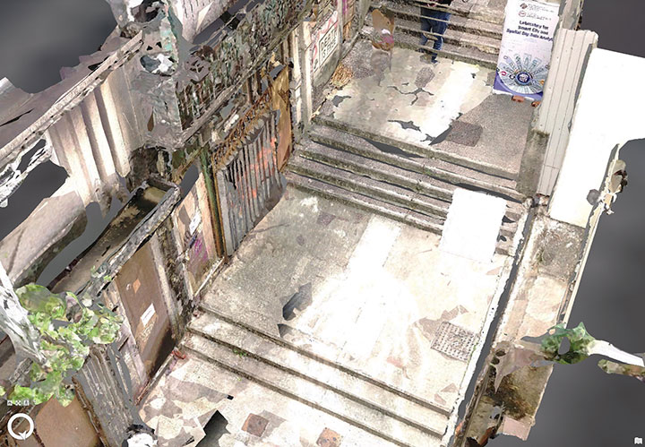
The PolyU team’s mobile mapping backpack. (Image: The Hong Kong Polytechnic University)
According to 2019 statistics, more than 10,000 residential buildings in Hong Kong are at least 50 years old. Most of these buildings lack 3D indoor building information models (BIM), which creates challenges when it comes to reconstruction or maintenance.
In response, a team at Hong Kong Polytechnic University (PolyU) has developed a lightweight and reliable 3D mobile mapping system in a backpack. The system can easily measure cities and obtain 3D maps with centimeter-level accuracy. It can be used to build spatial data infrastructure, which supports smart city applications in many fields.
The system uses advanced technologies such as simultaneous localization and mapping (SLAM), useful in urban canyons where GNSS signals can be spotty. It can carry out continuous data collection in complex indoor and outdoor environments, and is particularly suitable for high-density and complex urban environments, such as those in Hong Kong.
The mapper is providing a special boon to modular integrated construction (MIC) in the city. With MIC, free-standing integrated modules are prefabricated and then transported to the site for installation in a building. However, the trucks hauling the large components can’t always maneuver through narrow streets in Hong Kong’s urban areas.
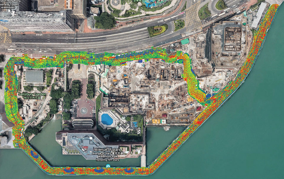
One of many narrow streets mapped in downtown Hong Kong. (Image: The Hong Kong Polytechnic University
To address the issue, the PolyU team collaborated with the Hong Kong Construction Industry Council, providing its mobile-mapping backpack to conduct 3D measurement of critical road sections. The project identified and mapped obstacles, and optimized the route for transporting oversized components to avoid narrow passages.
Mobile-mapping backpacks also can be used to create detailed indoor 3D models to support firefighting and provide evacuation routes for personnel at the fire scene.
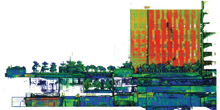
The route taken by the mobile mapping backpack carrier in the harbor area. (Image: The Hong Kong Polytechnic University)A sample point cloud from the mobile mapper. (Image: The Hong Kong Polytechnic University)
The mobile mapper is one of the technologies developed by PolyU’s Smart Cities Research Institute, established in 2020 to help address social issues and provide solutions for smart city development. In March, the institute’s projects received a gold medal at 2021 Inventions Geneva Evaluation Days.
Robots, UAVs go head-to-head in DARPA subterranean challenge
The U.S. Defense Advanced Research Projects Agency (DARPA) is looking for novel approaches to rapidly map, navigate and search underground environments during time-sensitive combat operations or disaster-response scenarios.
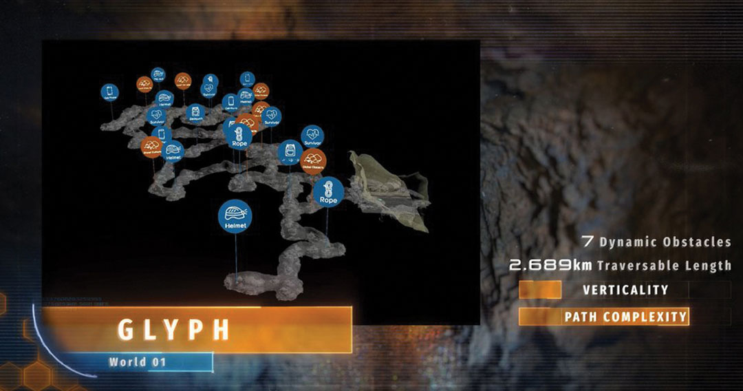
Eight teams have qualified for the DARPA Subterranean (SubT) Challenge Systems Competition Final Event. On Sept. 21–23, the teams’ robots will have to quickly navigate unfamiliar underground environments at the Louisville Mega Cavern in search of common items including backpacks, cell phones, trapped survivors and even invisible gas.
Those who find and identify the most items will win prizes of $2 million for first place, $1 million for second place and $500,000 for third place. DARPA-funded and self-funded teams have an equal chance to win prize money in the final event, DARPA states.
An Elios drone from team CERBERUS roams a moulin in an earlier challenge. (Photo: DARPA)
The SubT Challenge has held three preliminary events over the past two years — tunnel, urban and cave circuits. The final event will include elements of all three subdomains.
Tunnel systems can extend many kilometers in length with constrained passages, vertical shafts and multiple levels.
Urban underground environments can have complex layouts with multiple stories and span several city blocks.
Natural cave networks often have irregular geological structures, with both constrained passages and large caverns.
The SubT Challenge is run by DARPA’s Tactical Technology Office (TTO) to uncover innovative solutions to life-threatening, real-world impediments. “Complex underground settings present significant challenges for military and civilian first responders,” explained DARPA Program Manager Timothy Chung.
Chung added that the project has already achieved success. “Multimodal sensing developed through collaboration of robots during this project has increased the probability of correctly identifying important targets in real life,” he said. “The SubT Challenge is pushing researchers and startups to move to greater autonomy and has led to huge leaps in capability within subterranean environments while allowing learning from failure in non-critical situations.”
In addition to the Systems Competition involving physical robots, a Virtual Competition is being held. The teams that qualify for the final virtual competition will be announced later this summer. Teams in the Virtual final event will compete for up to $1.5 million, with additional prizes for self-funded teams in each of the Virtual Circuit events.
In the final competition, helmets, rope and even gas must be located. (Photo: DARPA)
FINAL EVENT TEAMS
DARPA-Funded
CERBERUS: CollaborativE walking and flying RoBots for autonomous ExploRation in Underground Settings