Tag: emergency response

  • Seen & Heard: Xona satellites, Russian bombs, better emergency response

    Seen & Heard: Xona satellites, Russian bombs, better emergency response

    “Seen & Heard” is a monthly feature of GPS World magazine, traveling the world to capture interesting and unusual news stories involving the GNSS/PNT industry.
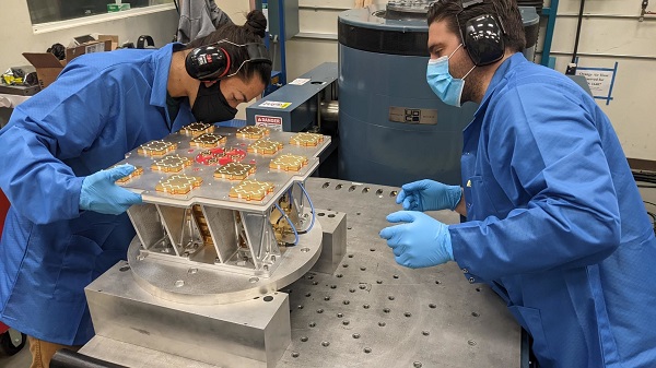
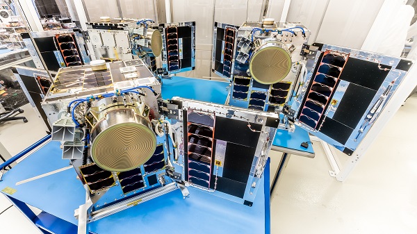

    Xona’s first demonstration mission successfully completed testing at Experior Laboratories and prepares for launch on a Falcon 9 in May. (Photo: Xona)
    Xona’s first demonstration mission successfully completed testing at Experior Laboratories and prepares for launch on a Falcon 9 in May. (Photo: Xona)

    TAKING GNSS PRIVATE

    At press time, Xona Space Systems’ first in-space demonstrator satellite, named Huginn, was ready to launch on May 25 aboard Space X’s Transporter 5 mission. Xona said the launch is a significant step toward realizing its high-performance commercial navigation system, a constellation of small, powerful satellites in low Earth orbit that will meet the navigation and timing needs of intelligent systems.


    Photo: gorodenkoff/ iStock/Getty Images Plus/Getty Images
    Photo: gorodenkoff/ iStock/Getty Images Plus/Getty Images

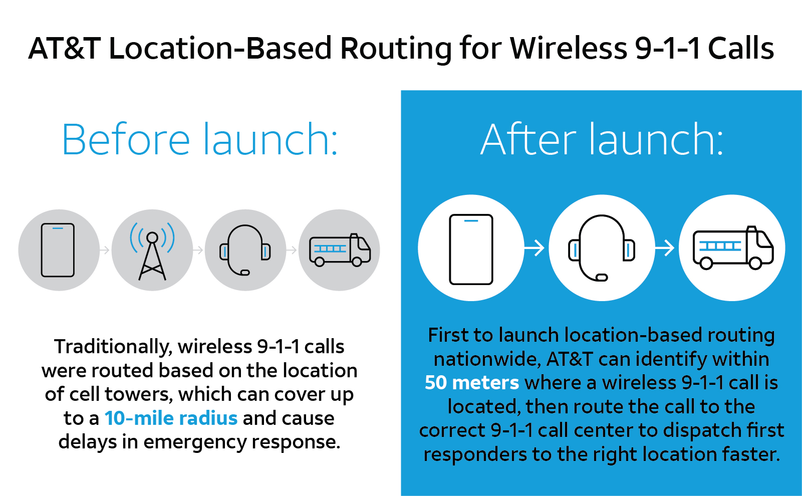
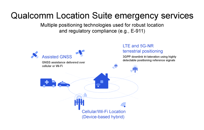
    GEOLOCATED EMERGENCY CALLS

    U.S. cellular carrier AT&T is rolling out location-based routing to automatically transmit wireless 9-1-1 calls to the appropriate call centers, rather than relying on which cell tower handles the call. Cell towers can cover a 10-mile radius, and overlap with more than one call-center boundary. With location-based routing, a device can be located and routed within 50 meters of the device location. The “Locate Before Route” feature from Intrado enables AT&T to use device GNSS and hybrid information to route the call to the right call center.


    Russian fighter jets in better times. (Photo: Aterrassi/iStock/Getty Images Plus/Getty Images
    Russian fighter jets in better times. (Photo: Aterrassi/iStock/Getty Images Plus/Getty Images

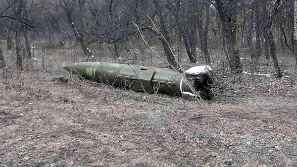
    RUSSIAN NAVIGATION CHALLENGES

    Russian jets have been found using GPS receivers, while ground vehicles use paper maps, according to the UK Express. The GPS receivers were found taped to the dashboards of Russian SU-34s downed in Ukraine because of “the poor quality of their own systems,” UK Defense Secretary Ben Wallace said in a speech. With many reports of maintenance and aging issues for the Russian military, most likely the jets did not have quality GNSS receivers rather than the fault lying with GLONASS.


    A Russian short-range ballistic missile, believed to be an unexploded Iskander missile, was found near Kramatorsk, Ukraine, in this photo released March 9 by Ukrainian authorities. (Photo: National Guard of Ukraine handout via Reuters)
    A Russian short-range ballistic missile, believed to be an unexploded Iskander missile, was found near Kramatorsk, Ukraine, in this photo released March 9 by Ukrainian authorities. (Photo: National Guard of Ukraine handout via Reuters)

    UNEXPLODED BOMBS MAPPED

    The HALO Trust is partnering with Esri to map unexploded ordnance in an immediate humanitarian response to the war in Ukraine. More than 10 million Ukrainians have been displaced by the war and many are forced to move across a landscape littered with unexploded rockets, bombs and landmines. In response, Esri has committed its cutting-edge geographic information system (GIS) software resources, expertise and staffing in support of HALO’s mission in Ukraine. HALO already is using GIS to map the heaviest conflict zones, and the partnership with HALO will support planning for future clearance operations.

  • HawkEye 360 adds satellites to geolocation constellation

    HawkEye 360 adds satellites to geolocation constellation

    Three HawkEye 360 radio-frequency geolocation microsatellites were launched May 25. The satellites, launched aboard SpaceX Transporter-5 mission, were built by Space Flight Laboratory (SFL) of Toronto. Three SFL-built satellites for greenhouse gas monitoring were also launched.

    The HawkEye 360 constellation detects and geolocates RF signals for maritime situational awareness, emergency response, national security and spectrum analysis applications.

    Once Cluster 5’s on-orbit checkout is complete, the HawkEye 360 constellation will be expanded to 15 satellites, doubling capacity and revisit rates. This significantly boosts the constellation’s ability to serve global customer demand and to monitor activity across places such as Ukraine.

    “Every enhanced satellite cluster we launch helps us deliver a higher density of valuable data to our government, commercial and humanitarian customers and partners – advancing our efforts to monitor global activities for a safer and more secure world,” said HawkEye 360 John Serafini. “Launch by launch, these space-based innovations are analyzing the knowns and uncovering the unknowns of the RF spectrum across the globe.”

    Cluster 5 includes enhanced antenna functions introduced with Cluster 4, which allow greater flexibility in geolocating signals across a wide range of frequencies important to customers.

    Cluster 4, launched April 1, has been completing checkout and moving into final formation to begin collecting data in late June. Cluster 5 is slated to achieve initial operating capability in August.

    Cluster 4 on orbit. (Image: HawkEye 360)
    Cluster 4 on orbit. (Image: HawkEye 360)

    HawkEye 360 plans to continue to grow the constellation to achieve revisit rates of about 15 minutes to support timely defense, national security and commercial applications.

    SFL has now developed 15 microsatellites for HawkEye 360 of Herndon, Virginia. SFL was selected for these missions due to the importance of formation flying by multiple satellites for successful RF geolocation.

    Other missions developed by SFL in the past two years include 16 communications CubeSats and three microsatellites designed for Earth observation, maritime tracking and atmospheric monitoring.

    In its 24-year history, SFL has developed cubesats, nanosatellites and microsatellites that have achieved more than 191 cumulative years of operation in orbit.

    HawkEye 360 Cluster 5. (Photo: HawkEye 360)
    HawkEye 360 Cluster 5. (Photo: HawkEye 360)
  • AT&T first carrier to route 9-1-1 calls with geolocation

    AT&T first carrier to route 9-1-1 calls with geolocation

    U.S. cellular carrier AT&T is rolling out location-based routing to automatically transmit wireless 9-1-1 calls to the appropriate call centers.

    Traditionally, wireless 9-1-1 calls were routed based on the location of cell towers, which can cover up to a 10-mile radius. This can cause delays in emergency response, especially when a call is made where state, county or city boundaries overlap.

    With location-based routing, a device can be located and routed within 50 meters of the device location. Through a new “Locate Before Route” feature from Intrado, AT&T can quickly and more accurately identify where a wireless 9-1-1 call is coming from using device GNSS and hybrid information to route the call to the correct 9-1-1 call center.

    Graphic: 911
    Graphic: 911

    The nationwide rollout has started and is available in Alaska, Colorado, Hawaii, Idaho, Montana, Oregon, Washington, Wyoming, Kansas, Illinois, Iowa, Minnesota, North Dakota, Missouri, Nebraska, South Dakota and Guam. Additional regions will be rolled out over the next several weeks. The nationwide rollout is scheduled to be completed by the end of June.

  • Avy launches response network for VTOL fixed-wing drones

    Avy launches response network for VTOL fixed-wing drones

    The Avy Aera departs from its docking station within minutes, shortening response times and reducing costs for first responders. (Photo: Avy)
    The Avy Aera departs from its docking station within minutes, shortening response times and reducing costs for first responders. (Photo: Avy)

    Dutch company Avy has launched its Drone Response Network, combining docking stations with autonomous aircraft that have vertical take-off and landing (VTOL) capabilities.

    The network offers drone coverage in a certain area, enabling instant deployment to support medical deliveries or emergency services during critical incidents.

    First flights are expected to take place in the first quarter of 2022.

    The network uses the Avy Aera autonomous drone that can carry up to 3 kg of medical goods over a distance of 100 km. It can operate year round, in rain and winds up to 45 kph, and is designed to meet the latest European Union drone regulations and United Nation requirements for aerial transport of medical goods.

    For medical delivery, the drone is equipped with Aera’s Medkit, which has a four-liter capacity and is fitted with sensors for immediate assessment. Medical products remain cooled at 2-6 degrees for at least 100 minutes in an ambient temperature of up to 40° C.

    The Avy Drone Response network is suitable for both urban and rural areas, delivering medicines, blood products, vaccines and other medical applications safer and twice as fast as road transportation, and is more environmentally friendly. It is expected to make a substantial contribution to achieving the goal of connecting hospitals and laboratories by air by 2023.

    The Avy Aera can also be integrated with a high zoom RGB and thermal camera system and used to quickly detect wildfires, spot people in distress at sea, monitor oil spills and assess the situation on the ground.

  • Applanix joins with NOAA on hurricane assessment imagery

    Applanix joins with NOAA on hurricane assessment imagery

    Hurricane Ida assessment imagery and data are now available. Ida was a Category 4 Atlantic hurricane from Aug. 26 to Sep. 4. (Screenshot: NOAA)
    Hurricane Ida assessment imagery and data are now available. Ida was a Category 4 Atlantic hurricane from Aug. 26 to Sep. 4. (Screenshot: NOAA)

    Applanix, a Trimble Company, and the National Oceanic and Atmospheric Administration (NOAA) have collaborated to provide critical information to first responders in the wake of Hurricanes Henri and Ida.

    Applanix’s high-accuracy direct georeferencing (DG) technology enabled NOAA to quickly collect aerial mapping imagery to

    1. provide valuable disaster remediation information to first responders
    2. demonstrate the value of mapping technology in preparing for and responding to emergency situations such as hurricanes, tornadoes and other disasters.

    Within hours of Hurricanes Henri and Ida making landfall, NOAA’s National Geodetic Survey collected post-storm imagery using the latest generation Digital Sensor System (DSS). The sixth-generation DSS, designed and manufactured for Applanix by Lead’Air, is the most powerful to date, thanks to several new features introduced within the solution:

    • simultaneous full color and near-infrared image capture using high-performance Phase One iXM 100 MP NIR and 150 MP RGB cameras
    • option to fly the cameras in wide coverage oblique or traditional overhead (straight line down) mode for mapping with uninterrupted measurement
    • embedded Trimble AP60 GNSS + inertial OEM DG solution for mapping without the need for ground control or aerial triangulation
    • Applanix POSPac post-processing software featuring the Trimble post-processed CenterPoint RTX correction service (PP-RTX) for centimeter-level mapping without GNSS reference stations
    • in-air development of raw imagery to JPEG-ready files for creating map products immediately upon landing
    • Lead’Air’s X-Track flight management, which enables the system to be flown outside of planned flight lines to follow roads, rivers and coastlines.

    Applanix’s DG technology suite provides direct GNSS inertial georeferencing, meaning that all pixels in the aerial images taken by NOAA are mapped at their exact location on the ground.

    “We have worked with Applanix for nearly 20 years,” said Michael L. Aslaksen Jr., chief of the remote-sensing division, NOAA’s National Geodetic Survey. “The level of sophistication they bring to aerial imagery and mapping keeps our team at the forefront of the industry. Their customer support team is always open to new ideas, new innovations and doing whatever it takes to get the job done.”

    First responders have access to this imagery and mapping within 24 hours via the cloud (as does anyone at storms.ngs.noaa.gov) and can map detailed response plans based on highly accurate data highlighting where the greatest need lies.

    Access to this turnkey emergency response imagery is available to any federal agency, municipality, insurance company or other entity that depends on highly accurate information to plan for and recover from disasters.

  • MCP works with NHTSA to assess GIS data sharing for 911

    MCP works with NHTSA to assess GIS data sharing for 911

    Photo: Thinkstock/Stockbyte/Getty Images
    Photo: Thinkstock/Stockbyte/Getty Images

    The National Highway Traffic Safety Administration (NHTSA) and Mission Critical Partners (MCP) will collaborate to assess the status of geographic information systems (GIS) within the 911 community.

    The goal of the initiative is to define what is required to achieve interoperable GIS data sharing nationwide. NHTSA selected MCP following a full and open solicitation and comprehensive evaluation of all proposals. The National 911 Program, housed within NHTSA, will lead the effort.

    Thousands of 911 centers in the U.S. have not deployed a nationally uniform, consistent GIS capability or mechanism for sharing GIS data. According to the NHTSA, GIS is an essential element of a truly interoperable, interconnected national Next Generation 911 (NG911) system.

    In 2019, the “National NG911 Roadmap,” a report published by the National 911 Program and supported by MCP, highlighted GIS as a significant barrier to achieving a nationwide system of systems. The report emphasized the need to develop standards, requirements and best practices for sharing GIS data. Later in 2019, the program published the “Strategic Plan for 911 Data and Information Sharing,” which also underscored the need for GIS data uniformity.

    Critical elements of the National 911 Program/MCP final report will include:

    • Current status of GIS. As 911 centers deploy NG911 and transfer calls across jurisdictions, the lack of GIS consistency poses significant problems. Many technical and non-technical challenges are associated with how GIS data is developed, processed, shared and stored among 911 entities. The report will identify the technical issues that the community must address.
    • Assessment of required entities, issues and partner agencies. Governance, administrative, financial and operational issues will be addressed, including resources, budget and organizations needed to overcome the gaps.
    • Strategies and metrics. The report will identify metrics to determine the accuracy of GIS data. It also will present strategies for overcoming the challenges found throughout the assessment process.

    The National 911 Program is responsible for improving coordination and communication among federal, state and local 911 centers, personnel, and telecommunications carriers and vendors. One of the program’s primary objectives is to develop and share resources concerning the technology used in providing 911 services.

    Mission Critical Partners (MCP) provides data integration, consulting, network and cybersecurity solutions for mission-critical communications networks in the public safety, justice, healthcare, transportation and utility markets.

  • Qualcomm Location Suite increases support for emergency services

    Qualcomm Location Suite increases support for emergency services

    Photo: FilippoBacci/E+/Italy
    Photo: FilippoBacci/E+/Italy

    To comply with Federal Communications Commission (FCC) E-911 regulations, Qualcomm Technologies has enhanced its Qualcomm Location Suite to provide improved horizontal and vertical positioning information. The upgrade will help first responders better determine the floor within a multi-story building from which an emergency call was placed.

    The Qualcomm Location Suite is deeply integrated with Qualcomm’s Snapdragon Mobile Platforms and Snapdragon Modem-RF Systems that power millions of mobile devices in the U.S. The suite has supported emergency location services in the U.S. and globally for two decades.

    The change will help mobile service providers comply with new E-911 regulations requiring that the horizontal and vertical position of each wireless caller be determined with a certain level of precision.

    The Qualcomm Location Suite uses GNSS with network-based positioning and dead reckoning to deliver accurate location with speed and efficiency. GNSS assistance is delivered over cellular or Wi-Fi, LTE and 5G-NR terrestrial positioning; cellular/Wi-Fi-based location is also provided.

    When an emergency call comes in, operators rely on a combination of triangulation of wireless signals and device positioning technologies, such as GPS, to provide the position of the caller. The use of technologies in the Qualcomm Location Suite is designed to result in highly accurate positioning information and the ability to share this reliable information with first responders, allowing them to reach the precise emergency site more quickly.

    Qualcomm
    Qualcomm
  • Trio of HawkEye 360 formation-flying microsatellites launched for RF geolocation

    Trio of HawkEye 360 formation-flying microsatellites launched for RF geolocation

    The HawkEye 360 constellation detects and geolocates RF signals for maritime situational awareness, emergency response, national security and spectrum analysis applications.

    Cluster 3 satellites fly in formation, joining Clusters 1 and 2. (Artist's rendering: Hawkeye 360)
    Cluster 3 satellites fly in formation, joining Clusters 1 and 2. (Artist’s rendering: Hawkeye 360)

    HawkEye 360 Inc. announced the successful launch of its Cluster 3 radio frequency geolocation microsatellites built by Space Flight Laboratory (SFL). Carried aboard the June 30 SpaceX Transporter 2 mission, the Cluster 3 formation-flying microsatellites quickly established communication with the company’s satellite operations center.  They join in orbit the HawkEye 360 Cluster 2 and Cluster 1 Pathfinder satellites.

    The HawkEye 360 Constellation detects and geolocates RF signals for maritime situational awareness, emergency response, national security and spectrum analysis applications. Cluster 3 significantly expands HawkEye 360’s capacity, and is part of its second generation of advanced RF-sensing satellites.

    “With the addition of our second-gen satellites, we’ll offer more frequent, timely and actionable data and insights to our government, commercial and humanitarian partners,” said CEO John Serafini.

    “The increased revisit frequency and capacity Cluster 3 brings to our constellation are essential to detecting, characterizing, and understanding the continuously changing RF activity important to our clients,” said Alex Fox, Executive Vice President for Sales and Marketing.

    Seven more clusters are fully funded and scheduled for launch in 2021 and 2022 to achieve collection revisits as frequent as every 20 minutes, Fox said. “Each cluster will offer new innovations to address a rapidly growing set of requirements needed by our defense, security and commerce clients. We plan on expanding the constellation past the initial 10 clusters to achieve near-persistent monitoring of global RF activity, which will drive even more value and ensure our continued dominance in the industry.”

    HawkEye 360 delivers a layer of intelligence to help understand human activity on Earth. The constellation detects, characterizes and precisely geolocates these RF signals from a broad range of emitters, including VHF marine radios, UHF push-to-talk radios, maritime and land-based radar systems, L-band satellite devices and emergency beacons.

    By processing and analyzing these RF data, the company delivers actionable insights for national, tactical and homeland security operations, maritime domain awareness, environmental protection and new applications in the commercial sector, the company said.

    The HawkEye 360 launch brings to 20 the total number of SFL satellites placed into orbit in less than a year. The Cluster 3 satellites were built on SFL’s 30-kg Defiant microsatellite bus.

    HawkEye 360 selected SFL due to the importance of formation flying by multiple satellites for successful RF geolocation. SFL is the acknowledged leader in developing and implementing high-performance attitude control systems that make it possible for relatively low-cost nanosatellites and microsatellites to fly in stable formations while in orbit.

    The previous HawkEye 360 satellite clusters built by SFL were the Pathfinder launched in 2018 and Cluster 2 in January. Each Cluster is comprised of three satellites.

    Other launches of SFL-built satellites in the past year include missions developed for the Norwegian Space Agency (NOSA) in Norway, the Dubai-based Mohammed Bin Rashid Space Centre (MBRSC) in the United Arab Emirates, GHGSat Inc. of Canada, Space-SI of Slovenia, and a Canada-based telecommunications company.

  • New HxGN Connect enables seamless, citywide collaboration

    New HxGN Connect enables seamless, citywide collaboration

    Hexagon AB has launched HxGN Connect, a software-as-a-service (SaaS) workspace for citywide collaboration enabling government agencies and other organizations to share data and coordinate action for ad-hoc, routine and emergency situations.

    Hosted in Microsoft Azure, HxGN Connect provides a networked workspace and unified view of information within and between entities. Participants can actively collaborate and securely share data as events unfold, overcoming technical and political barriers that result in missed opportunities, conflicting actions, errors and delays.

    With HxGN Connect, organizations can move beyond basic cooperation to true collaboration, where all participants gain mutual value. HxGN Connect is easily implemented and scaled — whether between multiple departments in a single agency or multiple organizations across cities and regions.

    “The future of smart cities lies in connected data communities that enable users to work with people and information irrespective of organizational and geographical affiliations or technology limitations,” said Hexagon President and CEO Ola Rollén. “HxGN Connect reimagines collaboration, breaking down barriers and bridging gaps between vertical sectors, organizational types and operational functions, which means safer cities, more effective services and happier residents.”

    HxGN Connect brings a city’s public safety, transportation, utilities and other related organizations together seamlessly. While users can visualize people, places and activities, and send messages and assign tasks to each other, all participants retain full ownership and control of their own data (nothing is stored in a central repository).

    The HxGN Connect dashboard. (Screenshot: Hexagon AG)
    The HxGN Connect dashboard. (Screenshot: Hexagon AG)
  • Shell and DJI partner on drone tech for energy industry

    Shell and DJI partner on drone tech for energy industry

    2,300-acre Shell Deer Park Refinery provides complex testbed for aerial inspections and incident response

    Photo: SimonSkafar/E+/Getty Images
    Photo: SimonSkafar/E+/Getty Images

    DJI is partnering with Shell Oil Company to create, test and deploy DJI drone technology at its Deer Park Manufacturing Complex to improve efficiency and worker safety during industrial inspections and emergency incident response.

    The Shell Deer Park drone team adopted DJI drones in 2016 to reduce the need to work at height while improving safety and cutting the cost of inspections in the process. As a Solution Development Partner, Shell will work with DJI to develop and test advanced drone solutions, like the DJI Matrice 300 RTK, that allow workers to automate required inspections of critical infrastructure like flare tips and floating roof tanks whose condition and activity are difficult to assess from ground level.

    “As one of the world’s largest energy companies, Shell has provided us with valuable insight into the unique challenges of conducting aerial inspections at one of its largest facilities where infrastructure exceeds the height of 250 feet off the ground,” said Cynthia Huang, until recently the director of business development at DJI. “Through our collaboration, DJI will receive valuable first-hand insight into the complexities of deploying drone technology at a world-class refinery, and co-develop new product features like AI Spot-Check that will allow Shell and other innovative energy companies to use drones to safely and easily conduct required inspections of critical infrastructure.”

    “Shell Deer Park is excited to become a Solution Development Partner with DJI as we continue to adopt drone technology,” said Shell Deer Park’s Chief Drone Pilot John McClain. “Through this partnership, Shell Deer Park will have access to some of the most advanced drone technology from DJI to help elevate workplace safety and improve efficiency across our operations in the world’s largest industry.”

  • Verizon to deploy RTK stations for ‘hyper-precise’ location info

    Verizon to deploy RTK stations for ‘hyper-precise’ location info

    Verizon logoUsing RTK’s pinpoint-level location data in the Verizon network is a building block to bring to scale emerging technologies such as driverless city zones, expansion of precision agriculture and drone delivery.

    Verizon has launched what it calls hyper-precise location using real-time kinematics (RTK) to provide accuracy within one to two centimeters on the Verizon network.

    Verizon has built and deployed RTK reference stations nationwide so that compatible internet of things (IoT) devices can receive the higher accuracy. Verizon is working to make RTK accessible with myriad device makers.

    RTK will also support emerging technologies that depend on high-level location accuracy, such as delivery drones and customer-approved location data for first responders in emergencies.

    RTK technology reduces the cost and risk associated with inaccurate location data, Verizon said in a press release. “Billions of IoT devices across a multitude of industries will benefit from improved location accuracy, with hyper-precise location information enabling a host of new services.

    “For instance, robotics at distribution centers will be able to perform more efficient, accurate and safe logistics operations. More accurate positioning can help speed deployment of high-value assets in emergency situations to the precise location, and more precise tracking of emergency equipment can provide faster redeployment in disaster response scenarios.”

    The rollout of its hyper-precise location services along with Verizon’s 5G Ultra Wideband network and 5G Edge will pave the way for more autonomous technologies, the company said.

    “We are scaling RTK to enable mobile location accuracy to within a few centimeters, transforming what is currently possible when it comes to location-enabled services and new IoT solutions coming onto the market,” said Nicola Palmer, chief product development officer for Verizon. “Continued growth in the IoT environment means billions of devices in fields where precision location services are becoming more critical, such as vehicle automation, unmanned aerial vehicles, precision agriculture technology, infrastructure monitoring, asset tracking and high-value shipping.”

    Image: 4X-image iStock / Getty Images Plus / Getty Images
    Image: 4X-image iStock / Getty Images Plus / Getty Images

    Reimagining road safety

    In partnership with HERE Technologies, Verizon is building next-generation technologies for vehicle and pedestrian safety using hyper-precise high-definition mapping and RTK.

    This work paves the way for connected services that are designed to drive road safety improvements. By creating a vehicle-to-network (V2N) communication system equipped with hyper-local location accuracy, collision avoidance applications can precisely identify vehicles, pedestrians and bicycles, and relay the information through Verizon’s 5G Edge and HERE’s AI to predict likely travel paths and warn vehicles of impending potential collisions. This partnership is one of multiple recent initiatives Verizon has taken to increase road safety.

    “Moving beyond the static fidelity of satellite-based location data enables an exciting new generation of connected, autonomous experiences,” said Jørgen Behrens, SVP, chief product officer at HERE Technologies. “By pairing HERE’s live, hyper-precise HD Map and HD Positioning technologies with intelligent RTK algorithms, and making that scalable, Verizon is putting a transformative level of location insights into the hands of developers and consumers alike.”

    Powering the autonomous future

    Hyper-precise location accuracy will be critical to advancing autonomous driving and together, Verizon and Renovo are ushering in a new era of transformative solutions critical for the future of autonomy on the road. These solutions leverage machine learning and RTK technology, powered by a combination of next-generation solutions such as 5G.

    “RTK is a critical technology for advanced driving assistance systems (ADAS). Accurate positioning helps ADAS vehicles navigate better, drive smoother, and react faster to the surrounding environment,” said Christopher Heiser, CEO and Co-Founder of Renovo. “Nationwide, reliable RTK networks make for a viable way to deliver these enhanced capabilities to mass-market cars and trucks. For companies that manage the huge datasets that power next-generation vehicle platforms like Renovo, this is very exciting.”

    IoT devices currently using RTK can be accessed and managed through Verizon’s ThingSpace management platform and APIs.

  • NSGIC issues guidance for states to strengthen address data programs

    NSGIC issues guidance for states to strengthen address data programs

    Guidance issued for states to strengthen address data programs complete and accurate data necessary for emergency response, other government services

    Cover: NSGIC reportA report issued by the National States Geographic Information Council (NSGIC) targets a key dataset for state governments. “Best Practices for State Geospatial Maturity: Addresses” is available now.

    “Addresses are created by local address authorities in city, county, and tribal agencies,” explained NSGIC Executive Director Molly Schar. “The data support delivery of services like utilities and emergency response, so getting it right is absolutely critical. NSGIC advocates the process of rolling up local address point records to the state to aggregate and then to the national level to save lives, reduce costs, avoid duplication, increase revenues, improve service and foster efficient and effective government.”

    The roll-up process is at the heart of an effort led by the U.S. Department of Transportation and supported by NSGIC to develop a National Address Database. Only 23 states have provided statewide address data to the national database, with five states providing partial data, and three states in the queue.

    For this publication, NSGIC tapped state geospatial information officers in Kansas, Massachusetts, Minnesota, New Mexico, New York, Utah and Vermont to identify key factors to the successful organization and coordination necessary to create and maintain strong address programs. These honor roll states scored in the top of the country in the area of address data in NSGIC’s 2019 Geospatial Maturity Assessment (GMA).

    NSGIC recently finalized an interactive GMA geospatial web map application with dashboards customized for each data theme allows users to take a deeper dive into the 2019 results, interacting with individual state and collective national results to bring to life the visual patterns and trends in the data.

    Geospatial data dashboards have become much more familiar to the public in recent months as most states and municipalities have adopted the interactive platforms to transparently display coronavirus information.

    Launched in 2009 to document geospatial development practices and uses, the GMA has provided a biennial snapshot of each state’s geospatial maturity. Inspired by the National Spatial Data Infrastructure theme grading undertaken by the Coalition of Geospatial Organizations (of which NSGIC is a founding member), an entirely new process was developed for the 2019 GMA.

    Nine-grade “report cards” were produced for individual state spatial data infrastructures and state geospatial coordination, in addition to overall theme and topical analysis.

    Over the next 18 months, additional focused guidance will be issued in the areas of overall statewide coordination and the key datasets for next generation 9-1-1, transportation, parcels, hydrography, elevation, and orthoimagery.

    “Collaboration, transparency, and increased efficiency in government are hallmarks of mature state GIS programs,” Schar said. “Through the Geospatial Maturity Assessment research and products, NSGIC is helping states set goals, identify opportunities for collaboration, shine a light on areas requiring attention, and build resources.”