Tag: emergency response

  • UAVOS completes tests for drone delivery of humanitarian relief

    UAVOS completes tests for drone delivery of humanitarian relief

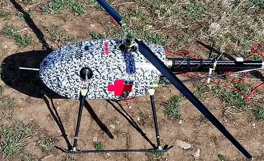
    UAVOS has successfully tested its cargo delivery UVH-170 unmanned helicopter. The trial aimed to validate a highly automated delivery flight from a vendor to a destination and back, across precisely pre-selected pathways.

    The flight took 1.7 hours and covered a standoff distance of 62 miles (100 kilometers). Critical humanitarian aid weighing 17.6 lbs (8 kg) was delivered with neither the need to land nor the need for a ground-control station on the receiving side.

    UAVOS’s UAS is equipped with line-of-sight data link (LOS) and satellite communication data link, which supports beyond visual line of sight (BVLOS) flights. Watch the cargo delivery UVH-170 UAV in action.

    UVH-170 unmanned helicopter is designed for commercial operations and immediate air response, emergency relief under demanding conditions and tight timescales. The aircraft’s high standoff distance makes it well-suited to humanitarian and disaster relief applications.

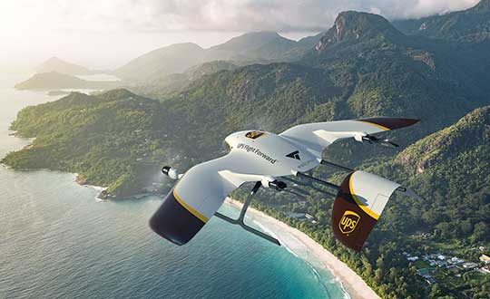
    The capabilities of the UVH-170 unmanned helicopter address many social (medical, pharmaceutical, remote communities, humanitarian aid, etc.) and economic (mining, oil and gas, courier, etc.) use-cases being requested by customers.

    The solution is based on the gasoline engine UVH-170 unmanned helicopter. With a maximum take off weight of 99 lb (45 kg), and a payload of up to 22 lb (10 kg), the UVH-170 flies at an altitude of less than 8,200 ft (2,500 m) at maximum speed of 74 mph (120 kph).

    “As we have seen during the trials, the customers can derive significant benefits from the use of the UVH-170 UAV,” said Aliaksei Stratsilatau, CEO and Lead Developer of UAVOS. “As a robust VTOL platform, the UVH-170 does not require any additional take off or recovery equipment, which makes it perfect for delivery to remote areas. Besides, the unmanned helicopter has demonstrated capability to operate in windy conditions with gusts more than 14 mps.”

    UAVOS has offices in Hong Kong, the United States and Europe. Among UAVOS’ unmanned technologies is the high-altitude pseudo-satellite (HAPS) ApusDuo, multi-platform autopilot solution for converting manned vehicles of all types into unmanned, and unmanned aerial vehicles aimed to counteract systems of electronic warfare.


    Feature photo: UVH-170 unmanned helicopter is designed for immediate deliveries. (Photo: UAVOS)

  • InnerSpace location platform supports public safety, COVID-19 response

    InnerSpace location platform supports public safety, COVID-19 response

    Photo: Kachura Oleg / iStock / Getty Images Plus / Getty Images
    Photo: Kachura Oleg /iStock / Getty Images Plus/ Getty Images

    Indoor location platform provides municipalities with emergency response and public safety solutions on existing Wi-Fi networks

    InnerSpace, a Toronto-based company, is offering its Wi-Fi-based indoor location intelligence platform to support all levels of government. The platform analyzes patterns and movement in public spaces using existing Wi-Fi networks.

    The platform is suitable for understanding the movement of people inside public spaces and can support emergency response strategies, social distancing programs and help smart cities implement effective security and public safety measures.

    “In response to the global COVID-19 pandemic, we have accelerated the delivery of our public safety solution inFORCE,” said James Wu, CEO, InnerSpace. “Our platform processes RSSI [received signal strength indication] data in real time and returns the industry’s most accurate location data available today. By using public Wi-Fi access points, municipalities have a way to quickly roll out new solutions at city-wide scale.”

    InnerSpace inFORCE was selected in a competitive process by the U.S. Department of Homeland Security, for its ability to use Wi-Fi to locate citizens and track emergency responders in an active shooter scenario.

    The same platform can be used in a wide variety of emergency situations such as the current COVID-19 pandemic. In addition to the company’s tracking capabilities, it’s analytics dashboard gives public safety offices an unprecedented view into how people leverage public spaces.

    “In times of emergency, it is reasonable to prioritize safety and public health to minimize the loss of human life,” said Cerys Goodall, president and COO, InnerSpace. “By providing municipalities with a system that can deliver line-of-sight into how people move in public spaces, we can inform response strategies, improve rescue efforts, and create an infrastructure to support better outcomes.”

    InnerSpace inFORCE ingests RSSI data and returns accurate anonymous indoor locations. The information can be connected directly into emergency response communications systems, building management and security systems, or analyzed by InnerSpace to identify critical patterns and trends in people’s movements.

  • DJI joins with firefighting provider Rosenbauer on digital emergency response

    DJI joins with firefighting provider Rosenbauer on digital emergency response

    Photo: Michael Chapman/iStock Editorial / Getty Images Plus/Getty Images
    Photo: Michael Chapman/iStock Editorial / Getty Images Plus/Getty Images

    Aerial perspective and mobile operation management system combine to inform deployment, give increased situational awareness, and save critical time

    A new strategic partnership between DJI and Rosenbauer International AG will enable emergency scenarios to be dealt with quicker, more safely and more efficiently, according to the companies.

    DJI makes civilian drones and aerial imaging technology, and Rosenbauer manufactures fire service vehicles and firefighting equipment.

    The two companies will work together to bring the benefits of digital emergency response management to anyone involved in being called to tackle an emergency situation.

    Whether used by a private company at an airport or industrial facility, or a local fire department called out to an emergency even in severe weather, an aerial perspective combined with Rosenbauer’s operation management system enables the situation to be quickly assessed and informed decisions made regarding the safest and most efficient deployment of personnel.

    Rosenbauer’s operation management system is the information management system for firefighting operations that supports emergency crews on site with relevant information such as fire safety maps, hazardous material data or vehicle rescue sheets.

    Data from DJI’s drone fleet management software, FlightHub, will be integrated into Rosenbauer’s operation management system, giving additional visual and thermal data to the decision maker of the operation.

    The information can then be relayed to operational units at the scene on a tablet or displayed on monitors back at the command center giving a full overview of the situation. Informed decisions can be made in real time regarding the efficient and safe deployment of resources such as personnel, vehicles and other equipment.

    Data safety is paramount and all information that is delivered to the Rosenbauer operation management system in real-time, and from DJI’s FlightHub, is stored on a server in the highly secure computer center of a well-known European telecommunication firm. The data traffic is secured and encrypted. During deployment, the data is also synced with all mobile end devices so that every operational team has the same information, and it is kept in a closed loop.

    “Speed and a truly complete overall picture are key criteria for success when emergency service teams have to make purposeful decisions under time pressure. We have already supported their efforts to meet these criteria with our IT solutions, which range from efficient vehicle management to navigation, right through to alarm applications,” said Dieter Siegel, CEO of Rosenbauer International. “This cooperation with DJI enables us to consolidate our role as a digital pioneer while we work together to develop an integrated technology for comprehensive, data-based firefighting and disaster management.”

    “DJI is proud to bring its drone technology to support Rosenbauer’s excellence in fire apparatus manufacturing and its vision of empowering firefighters with the best possible tools for emergency response and disaster relief. At DJI, we aim to provide reliable, scalable drone offerings that empower firefighters, search and rescue and public safety teams to benefit from this technology,” said Roger Luo, President, DJI. ” It plays an increasing role in saving lives, time and resources on a daily basis. This integration is an important step for this long-term partnership, and our commitment demonstrates an increasing maturity in the adoption of drones for firefighting professionals.”

  • UPS to develop new delivery drones with Wingcopter

    UPS to develop new delivery drones with Wingcopter

    UPS Flight Forward (UPSFF) is collaborating with German drone-maker Wingcopter to develop the next generation of package delivery drones for a variety of use cases in the United States and internationally. UPSFF is a subsidiary of UPS dedicated to drone delivery.

    UPS chose Wingcopter for its unmanned aircraft technology and its track record in delivering a variety of goods over long distances in multiple international settings.

    “Drone delivery is not a one-size-fits-all operation,” said Bala Ganesh, vice president of the UPS Advanced Technology Group. “Our collaboration with Wingcopter helps pave the way for us to start drone delivery service in new use-cases. UPS Flight Forward is building a network of technology partners to broaden our unique capability to serve customers and extend our leadership in drone delivery.”

    Drone fleet. As part of this collaboration — UPSFF’s first new relationship with a drone manufacturer since its formation — both companies will work toward earning regulatory certification for a Wingcopter unmanned aircraft to make commercial delivery flights in the United States. It also is a critical step toward building a diverse fleet of drones with varying capabilities to meet potential customer needs.

    The Wingcopter drones feature vertical takeoffs and landings in tight spaces, transitioning to efficient, high-speed horizontal flight, enabling ranges suitable for a variety of uses. These capabilities will allow UPSFF to begin developing solutions that, if approved, will go well beyond the healthcare and retail industries to solve long-standing challenges for high-tech, industrial manufacturing, hospitality, entertainment and other customers.

    Wingcopter  drones have taken part in numerous beyond-visual-line-of-sight (BVLOS) projects and been used by diverse customers around the world — from commercial, factory-to-factory deliveries to life-saving humanitarian projects and emergency medical supply.

    For example, Wingcopter delivered insulin to an Irish island in the North Sea that is frequently cut off from the mainland because of bad weather. On the South Sea island of Vanuatu, the start-up, on behalf of the local Ministry of Health and supported by UNICEF, successfully set up an on-demand vaccines supply, delivering the urgently needed serums within minutes to multiple different health centers.

    Core innovation. The company’s electric vertical takeoff and landing drones have a patented tilt-rotor mechanism, which enables a seamless transition between two drone modes: multicopter for hovering and fixed-wing for low-noise forward flight. The aerodynamic Wingcopter aircrafts operate with stability even in harsh weather conditions.

    In 2019, UPSFF began operating commercial drone delivery flights in the UPS network, starting with delivery service at WakeMed’s flagship hospital and campus in Raleigh, N.C. Since then, the company has delivered thousands of medical samples via drones, supplementing a ground courier service.

    UPSFF later announced plans to establish drone delivery services on several healthcare campuses and has been exploring the use of drones to deliver retail, prescriptions and medical products in residential settings.

    In September 2019, UPSFF received the U.S. government’s Standard Part 135 certification to operate a drone airline, and has also completed drone deliveries under the U.S. Federal Aviation Administration’s Part 107 rules within the FAA’s Integration Pilot Program.

    “We are proud to partner with UPS, a global giant in delivery and logistics. Together we aspire to extend the speed and reach of package delivery,” said Tom Plümmer, Wingcopter chief executive officer and co-founder. “Our vision has always been to leverage technology to improve the lives of people around the world, and the strategic relationship with UPS will further accelerate our growth and global expansion, strengthening our role as an industry leader in drone technology.”

  • Esri provides mapping software for organizations fighting COVID-19

    Communities in need of resources can access location intelligence technology at no cost with six-month trial

    Logo: EsriLocation intelligence company Esri is making its software available to public and private sector organizations fighting the coronavirus (COVID-19) pandemic.

    The COVID-19 outbreak has escalated rapidly across the globe, and with municipalities struggling to respond, Esri has built out resources to help organizations understand the potential impact of the disease on public health, as well as potential community risk areas and their capacity to respond.

    A COVID-19 GIS Hub site provides much of this essential data, including case locations and social vulnerability, that communities and health organizations can use to inform their response.

    To help public health agencies and other organizations jump-start their response, Esri is providing the ArcGIS Hub Coronavirus Response template at no cost through a complimentary six-month ArcGIS Online subscription with ArcGIS Hub. The template includes examples, materials, and configurations to rapidly deploy a local ArcGIS Hub environment. ArcGIS Hub is a framework to build a website to visualize and analyze the crisis in the context of an organization’s or community’s population and assets.

    “Esri has always prioritized assisting communities during large-scale emergencies and natural disasters,” said Jack Dangermond, Esri founder and president. “For the past 25 years, our Disaster Response Program provides data, software, configurable applications, and technical support for emergency operations. We consider it part of our mission to provide these services free of cost during this time of national crisis.”

    For more information on the complimentary software and the disaster relief support, visit esri.com/disaster.

  • Polaris joins Mark43 on location-enabled dispatch for emergency departments

    Polaris joins Mark43 on location-enabled dispatch for emergency departments

    Polaris Wireless is partnering with Mark43 to integrate 3D location technology into computer-aided dispatch systems for public safety organizations. Polaris Wireless is a provider of software-based wireless location solution.

    The joint solution will enable police and fire departments to track personnel and assets with pinpoint location, including indoors and in high-rise buildings, with floor-level accuracy. It delivers enhanced situational awareness and improved operational efficiency, which helps save lives and additional costs.

    Mark43 Computer Aided Dispatch and Automatic Vehicle Location. (Screenshot: Mark43)
    Mark43 Computer Aided Dispatch and Automatic Vehicle Location. (Screenshot: Mark43)

    Mark43 is a cloud-based public safety software provider. Its Mark43 CAD software provides mobile field units with precise information on laptops or tablets inside a vehicle. Built on AWS GovCloud, Mark43 works with police and fire departments to make sure web-connected units stay mobile in the cloud.

    With the addition of 3D location, command and control centers can direct firefighters to the correct floor in a structural fire or ensure SWAT teams enter at the correct floor of a high-rise building. In more routine situations, such as tracking officers or equipment in a large municipal headquarters, 3D location helps increase efficiency and allocate resources more wisely.

    Mark43 is purpose-built in the cloud to support interoperability with third-party systems and devices. This enables the Mark43 CAD to seamlessly integrate with the Polaris Wireless 3D Location Platform, which is cloud-based and available to application developers via a standard Android and iOS Software Development Kit (SDK).

    The platform relies on Polaris Wireless’ 3D location technology, which is able to locate devices on the vertical axis within 3 meters, floor level, utilizing all available signals and sensor measurements combined with the company’s patented algorithms.

    Screenshot: Mark43
    Screenshot: Mark43

    By operating independently, or “over the top,” of wireless carrier networks, the platform is universal, enabling applications to locate any device on any network — an important consideration when police and fire departments operate devices across several networks.

    “Giving command and control centers full visibility into first responders’ locations is crucial when it comes to emergency dispatch, where every second counts,” said Scott Crouch, Mark43 co-founder and CEO. “We are always aiming to integrate the best possible capabilities into our suite of offerings, and we look forward to working with Polaris Wireless to increase safety and efficiency for our first responders.”

    “Our 3D location is enabling new use cases in public safety applications with our partnership and integration into Mark43 CAD systems,” said Amir Sattar, senior vice president of operations for Polaris Wireless. “Dispatching police and firefighters to the precise location, including the correct floor number, represents a major advancement for public safety and a significant benefit for the communities they serve.”

    Polaris Wireless and Mark43 are exploring opportunities to trial the application with public safety organizations.

    Attendees at the NENA 2019 Event (June 14-19) in Orlando, Florida, can visit Mark43’s booth #321 to learn more.

  • Orolia launches Galileo-enabled personal locators in Europe

    Orolia launches Galileo-enabled personal locators in Europe

    The upgraded McMurdo FastFind 220 and Kannad SafeLink Solo Personal Location Beacons. (Photo: Orolia)
    The upgraded McMurdo FastFind 220 and Kannad SafeLink Solo Personal Location Beacons. (Photo: Orolia)

    Orolia’s McMurdo FastFind 220 and Kannad SafeLink Solo personal location beacons (PLB) now operate with the Galileo GNSS system.

    The PLBs are the first of a series of new solutions coming from the European Union-funded Helios project, led by Orolia, which has been set up to leverage the power of the new satellite system.

    With Galileo, the upgraded multi-constellation PLB receivers offer increased global coverage and support accelerated rescue missions. Location detection is enhanced and can be more precise as the PBLs receive coordinates from the Galileo satellite network in addition to GPS. Signals can even be detected in high-sided locations, such as canyons.

    “We are thrilled to be launching our upgraded PLBs in the European and U.S. markets,” said Chris Loizou, vice president of maritime at Orolia. “The combination of both Galileo and GPS GNSS capability means that our customers will benefit from coverage that spans from the North to the South Pole. We work tirelessly to push the boundaries of product innovation and, ultimately, to give people the best chance of being rescued in an emergency situation.”

    The McMurdo FastFind and Kannad SafeLink PLBs are part of Orolia’s comprehensive search-and-rescue ecosystem and join the McMurdo SmartFind G8 and Kannad SafePro series EPIRBs as Galileo-capable rescue beacons.

  • USGS selects Dewberry to complete lidar mapping for Florida

    This digital elevation model (DEM) indicates the type of data currently being acquired across Florida. (Photo: Dewberry)
    This digital elevation model (DEM) indicates the type of data currently being acquired across Florida. (Photo: Dewberry)

    High-resolution airborne lidar data to be acquired over 34,000 square miles for disaster response and recovery.

    Under an active Geospatial Products and Services contract, the U.S. Geological Survey (USGS) has selected Dewberry, a privately held professional services firm, to complete a statewide lidar mapping project for Florida. The project is funded by the Florida Division of Emergency Management and USGS as part of Hurricane Irma Disaster Recovery, Response and Preparedness measures being conducted by the state and federal agencies.

    The approximately $20 million project includes airborne lidar data acquisition, ground survey and preparation of bare earth point cloud and digital elevation model products for various applications to support response, recovery, and preparation for future storm events.

    The resulting quality level 1 data will be primarily used for hydrologic and hydraulic modeling and many engineering applications by the water management districts to mitigate the impacts of flooding caused by these storms.

    USGS and the Federal Emergency Management Agency (FEMA) will also utilize these data for various flood studies. The project encompasses an area of more than 34,000 square miles.

    Photo: Dewberry
    Photo: Dewberry

    Dewberry has acquired and processed nearly 22,000 square miles of lidar data for various local, state, and federal agencies in Florida within the past three years.

    “As we continue to map the state of Florida, we’re looking forward to using the best technology and personnel to complete such a vast undertaking,” said Dewberry Vice President and Director of Remote Sensing Amar Nayegandhi, CP, CMS, GISP. “Once these data are acquired and analyzed, they will be able to support USGS, FEMA, the Natural Resources Conservation Service, the Florida water management districts, and several other state and local agencies in their mission to better prepare for natural disasters and minimize loss of life and property; and use these scientific data to enhance and protect our quality of life.”

    Dewberry will serve as prime contractor for this project and will perform the majority of the data production. The firm is teaming with seven other partner firms including Woolpert Inc., Quantum Spatial Inc. and Digital Aerial Solutions, Inc, which will acquire and process data to support the project.

    Dewberry’s other subcontractors will be tasked with acquiring airborne lidar data.

    “We have 11 aircraft with top-of-the-line airborne lidar sensors being deployed for data acquisition starting in early December,” said Dewberry Senior Project Manager Elise MacPherson, PMP. “I’m excited to manage this project and support the needs of USGS, their partner federal agencies and the many stakeholders in Florida.”

  • ION GNSS+ 2018 plenary keys in on Emergency Location Service in Android

    ION GNSS+ 2018 plenary keys in on Emergency Location Service in Android

    Reflecting the dramatic changes and advances that have taken place in the applications of positioning technology over the last decade, the plenary session of the 37th meeting of the Institute of Navigation’s Satellite Division did not discuss satellites at all. Instead, two keynote speakers elaborated upon the application of positioning to emergency response services and to airborne mapping with lidar technology.


    Emergency Location Service (ELS) in Android

    Steve Malkos, technical program manager at Google, told the audience of approximately 800 that the new emergency location service “is our passion project at Google. Just last week we announced the expansion of ELS into the U.S. It’s here and it’s ready today. But the work isn’t done yet because of various challenges.” Google’s goal is 1-meter location accuracy for all 911 calls placed on cell phones. The algorithms discussed at ION this week, Malkos said, are part of what is driving Fused Location Provider (FLP)
    toward this future.

    In FLP, locations are computed directly on the handset as opposed to the older method, which computes on the carrier’s cell network. Google’s indoor solution consists of wi-fi augmented by network information.

    Recently released statistics show emergency call usage has flipped from what it was only a decade ago. Now, only 20 percent of emergency calls are placed on landlines. Eighty percent are placed on wireless devices.

    Malkos replayed audio from a call made recently, prior to activation of ELS, that generated a location on Miami’s emergency services of 500 meters away from the basement ballroom of the conference hotel.

    Domino’s Pizza, Uber ride service and Facebook all now use the hybrid derived location from cell phones, while emergency services typically use the location computed on the carriers’ network, and relying on cell-tower positioning. Cells range from 100s of meters to kilometers in size.

    ELS has been live in the U.K. since June 2017. Since its activation, British Telecom’s mean radius accuracy on emergency calls went from 2 kilometers to 43 meters 85 percent of timeION20.

    Malkos discussed the challenges of privacy, altitude (Z-axis) and the related difficulties in the urban high-rise landscape of floor determination and infering floor labels.

    Overall, he said, statistics show that each 1 minute sooner of arrival of emergency services translates to 10,000 saved lives.

    A Lidar History

    Paul LaRocque, vice president of special projects at Teledyne Optech gave an overview of light detection and ranging (lidar) development through the lens of a one-company centric history, that of Teledyne.

    Lidar got started in 1969, within a decade of the invention of the first laser. It began with early work in marine mapping and bathymetry from onboard ships. Airborne lidars developed in the late 1970s, looking at icefields in the Arctic, and was done at first with no absolute positioning to aid in analyzing the results..

    Early on, developers discovered that airborne lidar can get to the bare earth, penetrating under forest canopy. This eventually led to the recent dramatic discoveries of long lost Mayan cities, covered by jungle.

    In the early 1990s, GPS and inertial technologies converged, with some miniaturization, to enable building of integrated technology systems that added absolute positioning to the lidar toolbox.

    LaRocque provided a quick look at the National Geographic story, based on data from a three-wavelength Teledyne Optech Titan, one of several current machines that are generating data at millions of shots per second. Increasingly, it’s the software processing that brings out the accuracy, for example, centimeter accuracy surveyed from a kilometer up in the air.

    Challenges enumberated:

    • the speed of light is not fast enough.
    • the Earth is not flat enough.

    Teledyne developed PulseTRAK technology to cope with the “blind zones” generated by these two challenges, so as to not lose data in any gaps.

    The new frontier is spaceborne lidars. Teledyne is involved in a project tenerating lidar data from the surface of Mars on a Canadian space agency mission. This led previously to the discovery of snow in the atmosphere of Mars. The OSIRIES-Rex mission now on its years-long voyage to a very-far off asteroid represents the furthest adventure of lidar in space. The project will collect data on the asteroid’s surface and beam it back to Earth, as well as eventually returning some core samples.

  • UAVs, new sensors and mapping help with volcano eruption response

    A team of five volunteers armed with drones, advanced sensor systems and GIS technologies joined the response effort at Kilauea Volcano Lower East Rift Zone to assist in tracking and predicting the ongoing volcanic eruption.

    Using small unmanned aerial systems (sUAS) together with air-quality sensors, advanced imaging tools and Esri’s spatial analytics and mapping, the team from the Center for Robot-Assisted Search and Rescue (CRASAR) provided real-time aerial views of the eruption.

    The CRASAR team identified a new fissure not visible from the ground, projected the lava flow rate during the night when manned helicopters were not allowed to fly, and provided ongoing data collection from new thermal sensors technology.

    The CRASAR response marks the first known use of sUAS for emergency response to a volcanic eruption and first known use of sUAS for sampling air quality. The CRASAR team provided Hilo Fire Department and the Civil Defense with live streaming of video from the sUAS over the new FirstNet cellular network.

    “This latest CRASAR mission is another example of dedicated volunteers working together with private sector partners to deploy technology to save lives and property when disaster strikes,” said CRASAR Director and disaster robotics expert Robin Murphy. “With support from technology partners like Esri, Hangar Technologies, RemoteGeo and RMUS, we are able to both respond to active disasters but also demonstrate to the first responder community best practices and benefits of engaging robots and other technologies in disaster response.”

    CRASAR supported tactical response operations at the Leilani, Hawaii, eruption event May 14-19, supplementing the University of Hawaii Hilo’s (UHH) sUAS capabilities and allowing UHH sUAS operators to focus on geographical and volcanology.

    During the six-day Leilani deployment, the CRASAR team flew 44 sUAS flights, including 16 at night, using DJI 200, 210, Inspire, and Mavic Pro drones.

    Esri’s Drone2Map for ArcGIS together with Hangar’s Enterprise Platform for 360-degree imaging enabled rapid 360-imaging for situational awareness.

    DJI’s new XT2 thermal sensor provided unprecedented drone-based air-quality monitoring.

    Video and data were shared with local first responders using FirstNet, the first high-speed, nationwide wireless broadband network dedicated to public safety.

    The CRASAR response team included sUAS pilots Justin Adams of Constellation Consulting Group, David Merrick and Laura Hart of Florida State University Center for Disaster Risk Policy, Jon McBride of Rocky Mountain Unmanned Systems, and Robin Murphy of Texas A&M University. Funding was provided in part through research grants from an insurance partner and the National Science Foundation.

    “This eruption is especially impactful because of its location,” said Esri’s Public Safety Lead, Ryan Lanclos. “That makes the CRASAR’s use of drones and mapping technologies, and the near real-time situational awareness it provides of people, homes, businesses and infrastructure during this disaster, a resource first responders will be able to turn to time and again.”

    CRASAR’s deployment to Hawaii marked a number of firsts for technology applied to disaster response. To interact with the same GIS mapping and imaging technologies responders used on the scene at Kilauea Volcano Lower East Rift Zone, visit this page.

  • OGC hosts disaster preparedness workshop

    The Open Geospatial Consortium (OGC) is hosting the second Disasters Concept Development Study Workshop July 24-25 at the NOAA Auditorium in Silver Spring, Maryland.

    Organized by OGC, the workshop is sponsored by the Department of Homeland Security, the Federal Geographic Data Committee, the U.S. Geological Survey (USGS) and other government agencies.

    The workshop is part of the OGC’s Disaster Concept Development Study, and will shape future activities to be led by OGC regarding disaster preparedness and response, and to inform development of potential disaster spatial data infrastructures (SDI).

    According to NOAA, in 2017 in the United States there were 16 major natural disasters with costs that exceeded 306 billion dollars, shattering previous annual records.

    The workshop asks whether more lives can be saved and damages reduced by providing better discovery and access to data that will improve mitigation, preparedness, response and recovery from disasters.

    The ability to effectively share, use and reuse geospatial information and applications across and between governments and non-government organizations in support of disaster response and resilience depends on having a spatial data infrastructure in place when disaster strikes.

    The OGC is bringing together key stakeholders in the natural hazards disaster communities to advance the emerging Disaster SDI by conducting a study and developing a set of pilots over the coming years. OGC’s Disasters Interoperability Concept Development Study (CDS) will assess the current state of data and product exchange technologies as used in disaster planning, response, and recovery. The information gained in the CDS will aid in developing a series of future pilots that will in turn advance the state of SDIs that support disaster risk reduction across the globe.

    For more information on the Disasters Concept Development Study, visit the website or email [email protected].

    For more information on the Disasters CDS Workshop, including the agenda and how to register, visit the event page on the OGC website. Registration for the workshop is free but mandatory.

  • DJI: Drones rescued 65 people in 2017

    At least 65 people have been rescued by drones in the last year, according to a new report issued by DJI, a civilian drones and aerial imaging company.

    The report gathers accounts from news outlets and public safety agencies around the world, and includes 27 separate incidents on five continents.

    The report, “More Lives Saved: A Year Of Drone Rescues Around The World,” is available for download. It highlights how improved drone technology, rapid adoption by first responders, and smart aviation regulations have combined to increase the pace of drone use in critical public safety missions.

    In conjunction with an earlier report released in March 2017, DJI has now counted at least 124 people around the world rescued by drones.

    The new report found drones have

    • dropped buoys to struggling swimmers in Australia and Brazil,
    • spotted unconscious victims in sub-freezing weather in England and America, and
    • found stranded people in fields, rivers and mountains.

    “Drones allow rescuers a way to find missing people, deliver supplies like food and life vests, and cut search and response times from hours to minutes,” said Brendan Schulman, DJI vice president for policy and legal affairs. “When laws and regulations allow public safety agencies to deploy drones easily, rescuers are able to save time and money, protect their personnel, and most importantly, rescue people from peril.”

    More than one person a week was rescued by a drone over the last year on average, the report found, including at least 18 found by thermal imaging cameras that can sense a person’s body heat even in darkness or when hidden by thick brush.

    In one case, police in Lincolnshire, England responded to a car crash on a dark rural road on a cold night but were unable to find the driver. A drone with a thermal imaging camera spotted the driver in a ditch away from the crash scene, and captured the dramatic moments when it guided officers to find him. See video below.