Tag: emergency response

  • UASTrakker to showcase search-and-rescue drone system at AUVSI Xponential

    UASTrakker LLC is offering a new guidance system to enable first responders and maritime rescue units to use fully autonomous drones to help locate people lost at sea or in the wilderness.

    The company will showcase the system at AUVSI Xponential, scheduled for April 30-May 4 in Denver, Colorado.

    UASTrakker emergency response UAV.

    The emergency RF beacon tracking system for drones is based on the company’s core patent-pending technology, which uses an internet of things (IoT) edge computer, running the company’s proprietary software and algorithms to deliver an autonomous search-and-rescue (SAR) solution to the professional end user.

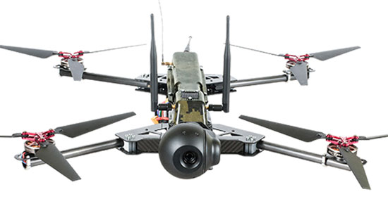
    UASTrakker integrated systems using an autonomous drone for locating emergency distress beacons, such as a personal locator beacon (PLB) or man overboard beacon.

    The UASTrakker system is capable of locating individuals stranded in floods, lost at sea or on land and is expected to be a key component of rescue efforts in maritime rescue, as well as SAR in the wilderness.

    How the system works

    Trained users operate the UASTrakker-enabled drone by initiating a flight plan to locate the last known position of the target. Once in the air, the drone will scan the emergency radio frequencies used by PLB beacons in distress, and provide situational awareness to first responders using its thermal, infrared and daytime cameras.

    When the target is located, the drone stores the GPS coordinates trail, and has the ability to drop lifesaving rescue supplies, or even lower a winch to a person, and rescue them to safety using a heavy lift drone.Ac

    During the entire rescue, UASTrakker streams live video into the company’s cloud computing solution of the entire flight, recording the physical location of the incident in day or nighttime conditions. This enables multi-agency collaboration on SAR missions to help locate the victim.

    According to the company, the UASTrakker system is compatible with many off-the-shelf drones, so it can be installed on medium-sized multi-rotors for short missions, a hybrid- electric plane for longer missions, or a heavy lifter for difficult to reach areas and rough weather.

    At any time, the user can take over control of the flying of the drone, and activate features like the winch. Cellular/satellite technology offers an almost unlimited range of control.

    UASTrakker ground control station.

    The UASTrakker company is also developing technology for moving ground control stations, so that drones will land more easily on a ship or moving platform like a SWAT vehicle.

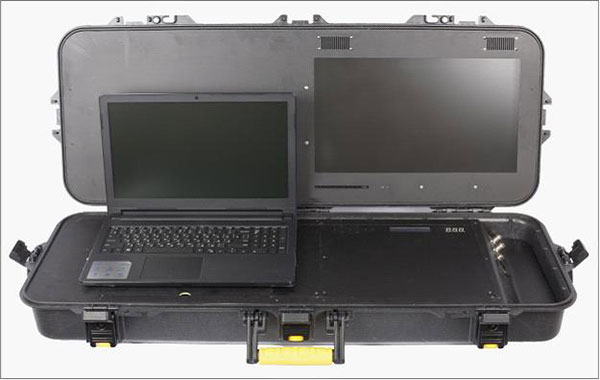
    The company’s proprietary artificial intelligence (AI)-capable internet console is expected to provide the pilot in command a first-of-its-kind online search grid, with online tools to initiate the autonomous flight search-and-rescue procedure.

    When other first responders have downloaded the UASTrakker app, they will have a collaborative map of the rescue operation, showing the drone position and the location of any emergency PLBs within range, while the drone autonomously locates and surveils them until rescuers can arrive.

    “A UASTrakker customized rescue drone can be deployed in many different emergency and disaster situations to locate survivors from maritime accidents, avalanches, hikers in distress or to locate stranded people after a natural disaster like a hurricane or flood, by tracking the PLB that is activated by the person in distress,” said Shawn Holmgren, CTO of UASTrakker.

    UASTrakker anticipates interest from government agencies including police, fire and rescue, and military, along with private individuals and commercial businesses.

    Holmgren will introduce the system at the Association for Unmanned Vehicle Systems International (AUVSI) Xponential show, booth 3233B. The company expects to launch the UASTrakker system by the hurricane season and summer of 2018.

  • Airbus to provide near real-time access to its satellite data

    Airbus has launched near real-time satellite imagery capabilities together with its 24/7 Emergency Image Delivery Service to aid those facing emergency situations.

    By leveraging the Kongsberg Satellite Services (KSAT) polar ground station in Svalbard, Norway, Pléiades and SPOT constellation images are now retrieved at every orbit, resulting in ultra-fast image deliveries after collection, anywhere in the world.

    In addition to this advanced reactivity, the 24/7 Service gives customers easy, immediate and round-the-clock access to a dedicated team of satellite experts who provide timely support in case of unplanned events.

    “When facing crises, time is critical. With our 24/7 Emergency Service, offering an image delivery time averaging two hours after acquisition, emergency situations can be treated with an even higher priority and our customers and partners will receive their mission critical satellite images much faster,” said François Lombard, Head of the Intelligence Business at Airbus Defence and Space.

    The 24/7 Emergency Image Delivery Service, relying on advanced Near-Real Time capability, was developed to answer customers’ specific requirements when facing unplanned events, geopolitical crises, natural or man-made disasters. It provides timely, reliable and accurate satellite images to assess damage and help mitigate the impact on those affected.

    The service ensures that satellite resources, such as the wide-swath SPOT or very high-resolution Pléiades constellations, are booked with the highest tasking priority, guaranteeing accelerated access to data worldwide.

    The service is also designed to be flexible, providing the possibility of last-minute modifications or cancellations. With this improved performance and capability, Airbus further enhances its ability to deliver timely and accurate satellite images using its smart and complete optical and radar constellations consisting of Pléiades & SPOT 6/7 satellites, DMC Constellation as well as TerraSAR-X and TanDEM-X radar satellites.

  • Polaris Wireless to deliver E911 indoor location to Alaska

    Polaris Wireless, a provider of high-accuracy, software-based wireless location solutions, has signed a multi-year, multi-phase contract for delivery of a wireless location solution that complies with the Federal Communications Commission’s (FCC) most recent E911 wireless location accuracy mandate with The Alaska Wireless Network, a company wholly owned by GCI Communication Corp (GCI).

    The first phase of the contract extension includes the Polaris Wireless Evolved Serving Mobile Location Center (E-SMLC) with hybrid location software for LTE networks that complies with FCC-mandated indoor location requirements. Subsequent phases include delivery of additional location technologies and hybrid algorithms as cellular networks and mobile devices continue to evolve and become more capable.

    Polaris Wireless describes its hybrid location solution as inherently future proof to take advantage of improvements in cellular networks and mobile devices. 

    “We are excited to continue working with GCI in providing our software-based location solutions,” said Amir Sattar, vice president of global operations for Polaris Wireless. “Polaris takes great pride in GCI trusting us to provide GCI E9-1-1 callers with the highest level of location accuracy when and where they need it most.”

    “We have enjoyed a long-term relationship with Polaris Wireless delivering wireless E9-1-1 location solutions for many years,” said Gene Strid, chief technology officer of GCI. “As the carriers must now locate E9-1-1 callers in challenging indoor environments, we are happy to leverage Polaris Wireless’s technological innovation and commitment in delivering high-accuracy, software-based location solutions.”

    “Polaris Wireless E-SMLC product leverages all available and emerging technology to deliver the best location position accuracy we can for our subscribers’ emergency calls,” said John Myhre, vice president of wireless technology at GCI.

  • Medical drone integrates augmented reality

    Medical drone integrates augmented reality

    A telemedical drone system with holographic technology can quickly put emergency physicians and lifesaving medical supplies in the hands of disaster survivors. The Telemedical Drone Project, known as HiRO (Health Integrated Rescue Operations), is being tested to support the Mississippi Department of Emergency Management, Homeland Security, the National Guard and NATO.

    Screenshot from HiRO video. (Courtesy of Paul Cooper)

    It is expected to be production-ready in early 2018.

    HiRO provides immediate access to a physician through a wireless video connection. When the portable critical care kit arrives, the doctor appears on a touchscreen display to direct treatment.

    Smart glasses allow a person on scene to move away from the kit while maintaining audio and visual contact with the physician. Holographic technology lets the physician to see the disaster scene and direct care through a hands-free, motion-enabled augmented reality headset.

    Osteopathic physicians Italo Subbarao and Paul Cooper partnered with Dennis Lott, director of the UAV program at Hinds Community College in Mississippi, to design and build a next-generation disaster drone.

    “These drones have impressive lift and distance capability, and can be outfitted with a variety of sensors, such as infrared, to help locate victims,” Lott said.

    HiRO drone and telemedical kit

    • Augmented reality (AR) operating on a Microsoft HoloLens headset enables a remote physician to treat multiple victims.
    • Automated medication bin allows remote physician to unlock specific compartments, giving bystanders safe access to medications and equipment supported by video guidance from the doctor.
    • Integrated holographic electronic health record system display helps remote physician monitor multiple patients in the field.
  • Esri, DigitalGlobe map California wildfires

    Using live data from USGS and Waze, a new Esri interactive map visualizes active wildfire locations and traffic alerts for Northern California.

    The map incorporates a new mapping technique to group traffic alerts at locations where there is a high density of alerts. This method enables faster and more effective visual analysis in areas where there are many alerts that would normally overlap.

    Active fire data displays the locations of large fire incidents in Northern California. Data is provided by the U.S. Department of Agriculture Forest Service and The Geospatial Multi-Agency Coordination Group, and is intended to give near real-time understanding of the situation on the ground.

    Location and status of active fires is updated throughout the day as new information is gathered by first responders.

    Data from Waze is reported by users of Waze and updated every two minutes. This data, provided by Waze through the Connected Citizens Program, contains filtered data for affected area including system-generated traffic jams and user-reported traffic incidents (including jams, accidents, hazards, construction, potholes, roadkill, stopped vehicles, objects on road, and missing signs).

    DigitalGlobe releases images of Northern California wildfires

    DigitalGlobe has released high-resolution satellite images of the wildfires burning in Northern California. These wildfires have killed at least 21 people, destroyed at least 3,500 structures, and burned more than 115,000 acres.

    The Oct. 10 images were collected using the Shortwave Infrared (SWIR) sensor on DigitalGlobe’s WorldView-3 satellite, which is uniquely able to pierce through the wildfire smoke to see where the fires are burning on the ground. For comparison, the ground and the fire line are completely obstructed by smoke in the natural color image of the same area (see the larger overview image on the first slide).

    The Oct. 11 images were taken by DigitalGlobe’s GeoEye-1 satellite. Some of these are natural color, while others are shown in the Very Near Infrared (VNIR), where burned areas appear gray and black and healthy vegetation is red.

    Additionally, DigitalGlobe has activated its Open Data Program, which provides imagery to support recovery efforts in the wake of large-scale natural disasters. Pre- and post-wildfire imagery of the affected areas are available to emergency responders on the Santa Rosa wildfires page.

    Fountain Grove Golf Club in Santa Rosa, California, natural color. (Satellite image ©2017 DigitalGlobe.)
    Fountain Grove Golf Club in Santa Rosa, California, natural color. (Satellite image ©2017 DigitalGlobe.)
    Coffey Park in Santa Rosa, California, color-infrared. Santa Rosa, California. (Satellite image ©2017 DigitalGlobe)
    Coffey Park in Santa Rosa, California, color-infrared. Santa Rosa, California. (Satellite image ©2017 DigitalGlobe)
    The northwest fire line of the wildfire that devastated Santa Rosa, California, taken by satellite Oct. 10. (Satellite image ©2017 DigitalGlobe)
    The northwest fire line of the wildfire that devastated Santa Rosa, California. SWIR image taken by satellite Oct. 10. (Satellite image ©2017 DigitalGlobe)
  • Esri tracks wildfires with interactive map

    Using live data from USGS and Waze, a new Esri interactive map visualizes active wildfire locations and traffic alerts for Northern California.

    The map incorporates a new mapping technique to group traffic alerts at locations where there is a high density of alerts. This method enables faster and more effective visual analysis in areas where there are many alerts that would normally overlap. Zoom in on the map to reveal the latest individual traffic alerts.

    Active fire data displays the locations of large fire incidents in Northern California. Data is provided by the U.S. Department of Agriculture Forest Service and The Geospatial Multi-Agency Coordination Group, and is intended to give near real-time understanding of the situation on the ground.

    Location and status of active fires is updated throughout the day as new information is gathered by first responders.

    Data from Waze is reported by users of Waze and updated every 2 minutes. This data, provided by Waze through the Connected Citizens Program, contains filtered data for affected area including system-generated traffic jams and user-reported traffic incidents (including jams, accidents, hazards, construction, potholes, roadkill, stopped vehicles, objects on road, and missing signs).

  • DigitalGlobe releases images of Northern California wildfires

    DigitalGlobe has released high-resolution satellite images of the wildfires burning in Northern California. These wildfires have killed at least 21 people, destroyed at least 3,500 structures, and burned more than 115,000 acres.

    The Oct. 10 images were collected using the Shortwave Infrared (SWIR) sensor on DigitalGlobe’s WorldView-3 satellite, which is uniquely able to pierce through the wildfire smoke to see where the fires are burning on the ground. For comparison, the ground and the fire line are completely obstructed by smoke in the natural color image of the same area (see the larger overview image on the first slide).

    The Oct. 11 images were taken by DigitalGlobe’s GeoEye-1 satellite. Some of these are natural color, while others are shown in the Very Near Infrared (VNIR), where burned areas appear gray and black and healthy vegetation is red.

    Additionally, DigitalGlobe has activated its Open Data Program, which provides imagery to support recovery efforts in the wake of large-scale natural disasters. Pre- and post-wildfire imagery of the affected areas are available to emergency responders on the Santa Rosa wildfires page.

    Fountain Grove Golf Club in Santa Rosa, California, natural color. (Satellite image ©2017 DigitalGlobe.)
    Fountain Grove Golf Club in Santa Rosa, California, natural color. (Satellite image ©2017 DigitalGlobe.)
    Coffey Park in Santa Rosa,  California, color-infrared. Santa Rosa, California. (Satellite image ©2017 DigitalGlobe)
    Coffey Park in Santa Rosa, California, color-infrared. Santa Rosa, California. (Satellite image ©2017 DigitalGlobe)
    The northwest fire line of the wildfire that devastated Santa Rosa, California, taken by satellite Oct. 10. (Satellite image ©2017 DigitalGlobe)
    The northwest fire line of the wildfire that devastated Santa Rosa, California. SWIR image taken by satellite Oct. 10. (Satellite image ©2017 DigitalGlobe)
  • Canada awards drone airspace management contract

    Canada awards drone airspace management contract

    Public Services and Procurement Canada has awarded a contract to Ottawa-based Kongsberg Geospatial for an emergency operations airspace UAV tracking system.

    Kongsberg Geospatial, an Ottawa-based developer of geospatial software technology, was awarded the contract to produce an Emergency Operations Airspace Management System (EOAMS) for evaluation by Canadian government agencies for safely managing drones at emergency and disaster scenes.

    The contract was awarded via a competitive request for proposals under the Canadian Safety and Security Program in a project for Defense R&D Canada’s Centre for Security Science.

    A small UAV is shown surveying the movement of a forest fire. The EOAMS would allow first responders to deploy drones at disaster scenes without endangering other emergency response aircraft or commercial flights. (Photo illustration: Kongsberg Geospatial)

    The EOAMS is a portable display that interfaces with a variety of local sensors, including radar and Automatic Dependence Surveillance — Broadcast (ADS-B) receivers to give a clear picture of the airspace around disaster areas.

    The system is intended to allow first responders to safely use unmanned aerial vehicles (UAVs) to survey the area, without risking collision with other emergency aircraft, including water bombers or rescue and police helicopters.

    The system would also provide a warning to first responders if unapproved UAVs approach the area – providing a degree of protection against what is becoming an increasing problem with the proliferation of small consumer camera drones at fires and accident scenes.

    The Government of Canada is expected to begin flight operations testing with the new Emergency Operations Airspace Management System in the summer of 2018.

    “Securing and managing the airspace around disaster scenes or at big public events is becoming a real concern for all levels of government,” said Paige Cutland, IRIS program director for Kongsberg Geospatial. “Even if a drone operator isn’t acting with malicious intent, they have the potential to cause considerable harm if, for example, they fly into the path of an air ambulance. We need effective tools to help prevent this while also allowing legitimate UAV operations to be safely integrated into the emergency airspace.”

    The new EOAMS will be based on Kongsberg Geospatial’s IRIS UAS airspace visualization system. The IRIS spatial awareness system evolved from technology originally developed for air traffic management display systems, and for supporting flight operations for military UAV systems like the U.S. Navy Triton Global Hawk.

    The system has been developed for safely operating UAVs beyond visual line-of-sight (BVLOS), and has been adopted by the FAA ASSURE group for use in research toward developing regulations for commercial BVLOS operations in the United States.

    “Kongsberg Geospatial has been pioneering innovation in airspace management for unmanned aircraft for over a decade,” said Ranald McGillis, president of Kongsberg Geospatial. “With the EOAMS project, we have the opportunity to introduce some really exciting capabilities in a portable system that will help first responders use UAVs in new and effective ways to support emergency response efforts.”

  • Hurricane barrels toward Texas, maps show impact

    Hurricane Harvey is hitting Texas with wind speeds of at least 111 mph. Widespread flooding is a risk for Texas and neighboring states as public safety groups and communities prepare.

    Esri has created a new Hurricanes and Tropical Cyclones Story Map that identifies the potential impact of the storm through a variety maps, including:

    • Public Information Map — identifies the current and recent location of Harvey as well as forecast positions and probable track; additionally, the shaded area is called the “cone of uncertainty,” the likely path of the center of Harvey.
    • Impact Summary Map — shows the storm surge by identifying locations most at risk for life-threatening inundation from storm surge; accordingly, to Esri’s data, the total population at risk is 248k people, 99k households, and 10k businesses.
    • Forecast Precipitation Map — forecasts the amount of rain expected within the next 72-hour period.

    Click here to view the story map.

    Hurricane-Harvey-Esri-storymap

  • Seeing the Great American Eclipse

    Photo: 2017 Eclipse/NASA
    Photo: 2017 Eclipse/NASA


    A total solar eclipse will cross the United States from coast to coast on Monday, Aug. 21 — the first solar eclipse in nearly 40 years.

    Not only is this is the first eclipse in the age of social media, it is the first with a path of totality crossing the Pacific and Atlantic coasts of the U.S. since 1918.

    Also, its path of totality makes landfall exclusively within the United States, making it the first such eclipse since the country’s independence in 1776.

    An interactive story map from Esri, Seeing the Great American Eclipse, features a collection of eclipse data such as the amount of exposure per location, traffic analytics and more.

    An estimated 1.85 to 7.4 million people will be traveling to the path of totality. The rapid population influx presents a unique challenge for national public safety agencies as well as state and local governments across the cities and towns where eclipse enthusiasts are expected to gather.

    Aside from potential record-breaking traffic jams, many are anticipating a significant strain on emergency resources and infrastructure (both physical and digital).

    Oregon in the Hot Seat. As the first state to experience the eclipse, Oregon is in the hot seat. It is not only one of the most populous states in the path of totality, but is expected to receive the most out-of-state visitors as well.

    During this unprecedented event, government agencies are going to need real-time situational awareness of personnel; resources; and infrastructures, such as freeways, in highly populated areas. Knowing who and what are at risk is critical, but knowing where when it matters most enables a cohesive response to any situation that might arise.

    In recognition of those needs, Oregon has developed the RAPTOR app (Real-time Assessment and Planning Tool for Oregon). Leveraging Esri technology, the online government resource adds the path of totality and other eclipse event layers to its situational awareness data.

    RAPTOR also allows users to quickly and easily digitize information from these events and put them onto maps, providing agencies with up-to-the-moment info on everything from traffic to weather.

  • Galileo search-and-rescue service officially launched

    The European Union's SAR zone.
    The European Union’s Galileo search-and-rescue zone.

    The Galileo Search And Rescue (SAR) service, made possible by the Galileo satellite constellation, is now active.

    Galileo SAR is Europe’s contribution to the COSPAS-SARSAT network, a distress alert detection and information distribution system best known for detecting and locating emergency beacons activated by aircraft, ships and hikers.

    By providing COSPAS-SARSAT with the coverage capacity of the Galileo constellation equipped with SAR transponders, Europe is helping to reduce the detection delay of a distress signal from up to several hours to 10 minutes.

    A return link, a signal informing the person in distress that the signal has been received and localized, will be added to the system by the end of 2018.

    Beacon Awareness Day

    The Galileo SAR launch day, April 6, is Beacon Awareness Day in the United States. It’s also named 406 day. 406 stands for 4/06 — the date in U.S. format — and the 406-MHz frequency of the SARSAT beacons.

    For Twitter and social media, special hashtags #406day, #406day17 and #savedbythebeacon already exist. The program has added the hashtag #getabeacon to complement it.

    The following video about the program focuses on maritime operations, which account for 75 percent of the alerts.

    Coming to the Rescue

    With Galileo, the time to identify the location of a beacon signal is reduced from several hours to a few minutes. At sea, this makes SAR rescue operations easier thanks to a narrowed “search box,” since the vessel in distress has less time to drift.

    On land, the quick acquisition of a precise position enables rescue teams to more quickly reach the operation zone and assist the victims.

    In the air, Galileo contributes to fulfilling International Civil Aviation Organization (ICAO) requirements for implementing the next-generation emergency management system Global Aeronautical Distress and Safety System (GADSS). In particular, it enhances location of an airplane in distress, which will be mandatory on Jan. 1, 2021.

    The Search And Rescue transponders on Galileo satellites can pick up signals emitted from any 406-MHz distress beacon anywhere in the service coverage area and transmit this information to the dedicated ground stations (MEOLUTs). The SAR/Galileo infrastructure is interoperable with GPS and GLONASS SAR transponders.

    Once the beacon is located by the MEOLUTs, the location data is sent to the COSPAS-SARSAT mission control centre (MCC), which distributes it to the relevant rescue centres. The rescue centres, under the responsibility of national competent authorities and administrations, then coordinate the required rescue efforts.

    Improving COSPAS-SARSAT

    Galileo plays an important role in the Medium Earth Orbit Search And Rescue system of COSPAS-SARSAT (MEOSAR), and provides a ground segment coverage of 40 million square kilometers over Europe as a contribution to MEOSAR global coverage.

    Thanks to the advanced European technology used, integration of Galileo into COSPAS-SARSAT improves the system by:

    • enabling faster detection and localization of distress signals anywhere in the service coverage area, reducing the delay between beacon activation and distress localization
    • making it easier to find the source of a signal by significantly boosting precision in comparison to the current situation
    • increasing availability and improving detection of signals in difficult terrain or weather conditions.

    The Galileo Search And Rescue service is one of the three services launched in December 2016 with the Initial Services. The SAR service represented just 1 percent of total Galileo program costs, but should result in thousands of lives being saved, according to the head.

  • DJI and DroneSAR launch rescue app for first responders

    DJI and DroneSAR launch rescue app for first responders

    DJI, maker of unmanned aerial vehicles, and DroneSAR, an Irish tech start-up for search and rescue, on Thursday announced a new search and rescue app that seamlessly integrates a drone’s unique aerial perspective on life-and-death searches into incident management software, ensuring rescue crews can use drones effectively to save lives.

    DroneSAR can stream live images and video, from a regular or thermal imaging camera, to an incident command center as well as other rescue teams on the ground. The software can tag the GPS coordinates of a victim and automatically transmit them by email or SMS, enabling ground crews to reach victims more quickly. Completed search patterns are all recorded and logged for easy handover to oncoming rescue crews.

    Screengrab: DroneSARThe app takes into account various types of terrain, allowing the drone to fly patterns to survey an area faster and more effectively. Flight paths can be adjusted for any terrain including hills, mountains, trees or flat land. The software allows users to choose an automatic aerial search pattern based on variables such as altitude, field of view, battery life and probability of detection. By organizing the process of data collection and providing a framework to manage and analyze it, DroneSAR ensures drones can be used methodically as part of a rescue protocol, allowing personnel to work more safely and effectively.

    “From understanding on how to use the technology, to communicating findings and data, to figuring out the most appropriate tactical approach, first responders can benefit greatly from this software app on our DJI hardware,” said Romeo Durscher, director of Education at DJI. “Many of the tasks and strategies deployed during a search and rescue operation can get sped up with automation, helping to reduce the time it takes to find a victim and save lives.”

    The software was developed based on research done by DJI in conjunction with the European Emergency Number Association and Ireland’s Donegal Mountain Search and Rescue team. The groups found that while a five-person rescue team on foot needs an average of two hours to find a victim in one square kilometer, a drone can do the job in 20 minutes or less while taking additional active steps to achieve a successful rescue.

    “Our aim is to save lives,” said Oisin McGrath, co-founder and CEO of DroneSAR. “Our software will reduce risk to search teams and reduce search time. If we can save just one life, that is mission success for us at DroneSAR.”