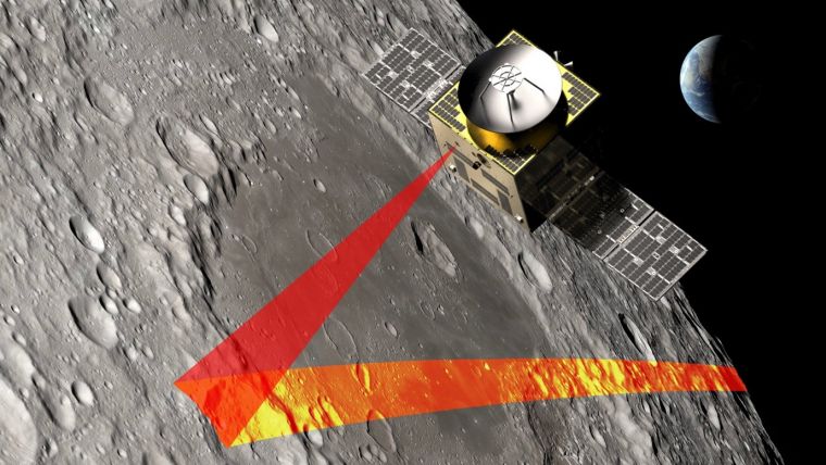
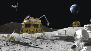
SFL Missions joins a team led by NUVIEW GmbH, which the European Space Agency has contracted to conduct a Pre-Phase A study for the Moonraker lunar mapping mission. This study launches under a new initiative for Small Exploration Missions. The Moonraker satellite will carry a laser scanner to create a detailed elevation map of the Moon’s surface.
The Moonraker mission will deploy a single orbiter in a low-altitude polar orbit around the Moon. The orbiter will host a lidar payload to capture highly accurate elevation points of the terrain. The team will use these data points to generate three-dimensional elevation models, which will guide the assessment and selection of future lunar landing sites.
Moonraker’s lidar data also seeks to advance broader scientific research. The mission will scan permanently shadowed regions to search for water ice and provide new insights into the Moon’s geology and internal composition. The Moonaker lidar will operate in two modes: one for broad-area scanning of the lunar polar regions and another for high-resolution surveys of specific areas of interest.
SFL Missions shared in a statement that Mission analysts are evaluating potential launch options and trajectories to efficiently enter lunar orbit. They are also studying how operational orbit parameters affect spacecraft design and payload data collection. The system design team focuses on accommodating the payload, configuring the spacecraft layout, and sizing subsystem components. They are designing the propulsion system to carry enough fuel for the transit phase and to maintain the operational orbit, compensating for disturbances from the Moon’s irregular gravity field. The team is developing detailed mission and system requirements to guide future design phases.
NUVIEW GmbH, based in Berlin, leads the Pre-Phase A study team, which includes several partners alongside SFL Missions. NUVIEW GmbH, a wholly owned subsidiary of NUVIEW Inc., is developing the world’s first commercial space-based LiDAR constellation for three-dimensional mapping of Earth.
SpacePNT has joined the European Space Agency’s Genesis mission, a navigation satellite project that will be the first to carry all four space-based geodetic techniques on board: GNSS, Satellite Laser Ranging (SLR), Very Large Baseline Interferometry (VLBI) and Doppler Orbitography and Radio-positioning Integrated by Satellite (DORIS).
SpacePNT’s NaviLEO spaceborne GNSS receiver technology was selected for the mission’s critical satellite navigation ranging instrument. Although NaviLEO has flight heritage in low-Earth orbit, it will be adapted for Genesis to operate in medium-Earth orbit at 6,000 km. The system will use a dual-antenna configuration to receive GNSS satellite signals from both zenith- and nadir-looking antennas.
The Genesis mission aims to update the International Terrestrial Reference Frame (ITRF), a global Earth model, targeting an accuracy of 1 mm and long-term stability of 0.1 mm per year. This will provide a precise coordinate system for advanced navigation applications.
On April 29, the European forest satellite “Biomass” was launched into space from Kourou aboard a European Vega-C rocket operated by Arianespace.
The company Beyond Gravity, based in Zurich, Switzerland, supplied several key products for this mission. Its high-power antenna and navigation receiver will provide the satellite’s precise position in orbit. Also, the satellite will be protected by the company’s thermal insulation.
The European Space Agency’s (ESA) “Biomass” mission will measure forest biomass and will observe the state and development of forests and advance our knowledge of the carbon cycle. Knowing the amount of carbon bound up in forest biomass will sharpen our understanding of climate change and its likely effects on the global carbon cycle. The satellite will orbit Earth at an altitude of 666 kilometers. The mission’s expected lifetime is at least 5.5 years.
“Forests are the green lungs of our planet, providing us with oxygen and storing carbon dioxide,” said Oliver Grassmann, Executive Vice President Satellites at Beyond Gravity. “With the environmental satellite Biomass, we are learning more about the importance of forests to our climate system. Contributing to the functioning of such a groundbreaking climate satellite with key products, like various antennas, our navigation receiver and our multi-layer thermal insulation is a great honor and extremely inspiring for all our colleagues.”
The Biomass mission will feature a new high-power antenna from Beyond Gravity that serves the data downlink needs of new Earth-observing satellites as they gather ever larger quantities of environmental data. The antenna has the size and shape of a large ice cream cone. While more and more Earth observation data from satellites is gathered, the satellite itself becomes smaller. Thus, there was a clear need for a smaller, more powerful data downlink antenna.
The X-band helix antenna design was developed for ESA by Beyond Gravity’s site in Gothenburg, Sweden. Beyond Gravity also provided the S-Band TTC (telemetry, tracking and command) antenna, which acts as a communication and control antenna for the satellite.
A new antenna from Beyond Gravity for data downlink will serve Biomass. It was developed through an ESA General Support Technology program contract with Beyond Gravity in Sweden. (Photo: ESA, Beyond Gravity)
Precise in-orbit position determination. The satellite’s position in space is determined to within centimeters using technology from Beyond Gravity’s site in Vienna, Austria. The more accurate the positioning, the more accurate the data provided by the satellite.
The receiver can process both GPS and Galileo signals. Beyond Gravity’s navigation receivers determine the position of approximately 25 satellites in space. The Beyond Gravity site in Tampere, Finland, produced the Reflector Deployment Interface Unit.
Multi-layer thermal insulation from Beyond Gravity made out of several layers of ultra-thin special polyimide foils will keep the satellite’s instruments at the required operating temperature despite the harsh thermal environment in space. Nearly every European ESA satellite is protected by thermal insulation from Beyond Gravity, which is designed and produced at the company’s sites in Austria. Beyond Gravity also produced the Eddy Current Damper, which is part of the spacecraft’s solar array wing and is providing the damping to slow down the deployment and prevent shocks at deployment completion.
“Seen & Heard” is a monthly feature of GPS World magazine, traveling the world to capture interesting and unusual news stories involving the GNSS/PNT industry.
Amazon sued for alleged privacy violations
Photo: Hispanolistic / E+ / Getty Images
Amazon is facing a lawsuit in Washington state, marking the first dispute under the state’s My Health My Data Act. The lawsuit accuses Amazon of violating privacy laws by collecting location data from millions of Americans without their consent through its software development kits used in various mobile applications. The collected data allegedly included information that could indicate a consumer’s attempt to acquire health services, violating the My Health My Data Act, which requires explicit consent for collecting and selling health-related data.
Europe’s first lunar lander underway
Photo: ESA
The European Space Agency (ESA) has partnered with Thales Alenia Space to develop Argonaut, Europe’s first lunar lander. This spacecraft will provide autonomous access to the Moon, supporting international exploration efforts. Starting in the early 2030s, Argonaut will conduct regular lunar missions, delivering infrastructure, scientific instruments, rovers and essential resources for astronauts. Designed to withstand harsh lunar conditions for up to five years, Argonaut will play a crucial role in sustainable lunar exploration, according to ESA.
Leica Geosystems, SCI-Arc equip future architects
Photo: Leica Geosystems
Leica Geosystems and the Southern California Institute of Architecture (SCI-Arc) have partnered to equip future architects with advanced technology skills. Leica is donating more than $200,000 in equipment, including lidar scanners, and offering expert guidance and scholarships to students. SCI-Arc students are applying this technology to create digital archives of Los Angeles structures and visualize rewilded wilderness.
In a recent study published by Nature Communications, researchers share that GNSS spoofing in conflict zones is disrupting wildlife tracking efforts, particularly affecting black-tailed godwits migrating through Eastern Europe. Researchers tagged 15 godwits in Finland in May 2024. Eight of these birds displayed spoofed geolocations during their migrations. The most significant spoofing occurred near Simferopol airport in Crimea, where birds were falsely located while flying over Ukraine or Romania. This spoofing added substantial errors to migration tracks, in one case creating a false 7,200-km round trip.
In partnership with the European Space Agency (ESA), EnSilica, a maker of mixed-signal application-specific integrated circuits, will design and develop a key silicon component to enable resilient multi-band global navigation satellite system (GNSS) capabilities. These are vital to ensuring the world’s critical infrastructure and services remain robust and secure in the face of evolving global threats, according to the company.
The ESA NAVISP Element 2 program helps to increase the competitiveness of participating European states in the global market for satellite navigation and enables these countries to be positioned to capitalize on emerging market opportunities across positioning, navigation and timing (PNT) technologies and services.
“As we and our infrastructure become ever more dependent on PNT services in everyday life, it is important to have highly integrated, resilient and precise technology sourced in Europe and the UK,” said Paul Morris, vice president of RF and communications business unit at EnSilica. “This collaboration will allow us to accelerate such technology, starting with a next-generation radio design enabling our partners to focus on integrating their custom algorithms.”
EnSilica has a growing satellite communications market footprint and is working with support from ESA and the UK Space Agency (UKSA), with the latter organization awarding the company £10.38 million ($12.8 million) in February 2025 for a development project under its Connectivity in Low-Earth Orbit program. Part of the company’s expertise is in architecting and implementing systems-on-chip with high-performance RF, including mmWave, and complex baseband processing.
Ian Lankshear, CEO of EnSilica, added, “I am extremely proud of our team to have been secured this agreement under the ESA NAVISP Element 2. This project will enable us to further enhance GNSS technology and continue to develop commercial solutions that are critical for resilient and reliable satellite navigation. We are grateful for the ongoing support from ESA and the UKSA, and we continue to focus on PNT and the broader satellite communications market as a key growth driver of our business.”
“Seen & Heard” is a monthly feature of GPS World magazine, traveling the world to capture interesting and unusual news stories involving the GNSS/PNT industry.
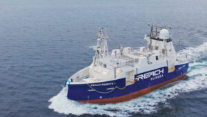
Autonomous vessel completes sea trials in Norway
Photo: Kongsberg Maritime
The Reach Remote 1, an uncrewed surface vessel developed by Reach Subsea in partnership with Kongsberg Maritime and Massterly, has been officially delivered after extensive sea trials overseen by Det Norske Veritas and the Norwegian Maritime Authority. This 24 m vessel is equipped with advanced hull-mounted survey sensors and a Work Class Electric ROV, designed to enhance subsea operations by improving efficiency, safety and environmental sustainability.
ESA in search of very low-Earth orbit technologies
Photo: VLEO
The European Space Agency (ESA) is seeking innovative space application ideas for very low-Earth orbit (VLEO), an orbital region between 100 km and 450 km. This initiative aims to explore new frontiers in space technology by soliciting creative solutions from researchers and innovators. ESA said VLEO presents several advantages, including reduced launch costs, enhanced Earth observation capabilities and a more harmless radiation environment. ESA is particularly interested in proposals addressing technological challenges specific to this orbital regime, such as atmospheric drag mitigation, advanced propulsion techniques and specialized satellite designs.
Car tracking leads to successful arrest
Photo: StarChase
The Pinole, Calif., Police Department utilized the StarChase GPS-based tracking system to safely apprehend suspects in a stolen vehicle. Instead of engaging in a dangerous high-speed chase, officers launched a GPS-enabled tracker that stuck to the vehicle, offering real-time location tracking. The Pinhole Police Department told The Richmond Standard, “This operation highlights how technology and collaboration keep our community safe — by reducing the dangers of high-speed pursuits while ensuring accountability and swift action.”
3D mapping of New Zealand coastline
Photo: nazar_ab / E+ / Getty Images
New Zealand has launched a coastal mapping project to help communities understand and mitigate climate change impacts. Led by Toitū Te Whenua Land Information New Zealand, the initiative will use lidar technology to create detailed 3D maps of up to 40% of the country’s coastline throughout three years. The $30.2 million project involves mapping 4,780 square km of coastal and seafloor terrain using specially equipped planes with high-resolution scanning equipment. Two suppliers, Woolpert NZ and NV5 Geospatial, will conduct the mapping across the North and South Islands, beginning in regions such as the Bay of Plenty and Invercargill.
The European Space Agency (ESA) has signed a contract with a consortium of European companies to conduct a definition study (Phase A/B1) and associated critical technology predevelopment to drive the development of optical positioning, navigation and timing (PNT) technology.
This initiative marks the initial phase toward a potential in-orbit demonstrator for optical time synchronization and ranging, which is scheduled for proposal at the ESA Council at the Ministerial Level in November. According to ESA, the primary objective is to validate inter-satellite optical links for future implementation in operational satellite navigation systems.
Optical technology presents promising advancements in navigation accuracy and robustness. While optical links, which use laser beams for data transmission, are already established in satellite communications, their application in navigation requires further technological development and in-orbit validation.
The consortium, led by German OHB System, comprises 33 companies from various ESA member states. Following the initial study, the next phase would involve developing and testing the technology in orbit to validate novel system concepts and explore new architectures. The results will assess the readiness of optical technology and inform decision-makers about its potential incorporation into future operational systems.
Laser-based technology offers the potential for enhanced system resilience and robustness, potentially reducing dependence on space atomic clocks and ground segments. Optical links also provide natural immunity to jamming and spoofing attempts.
The high data transfer rates of inter-satellite optical links could enable new, more robust architectures, supporting a multi-layer system approach to navigation. This aligns with the vision of ESA’s low-Earth orbit (LEO)-PNT program.
Additionally, optical systems can significantly improve the performance of current navigation systems. Experts anticipate achieving millimeter-level spatial accuracy and picosecond-level timing, which could ultimately lead to enhanced services benefiting billions of users worldwide.
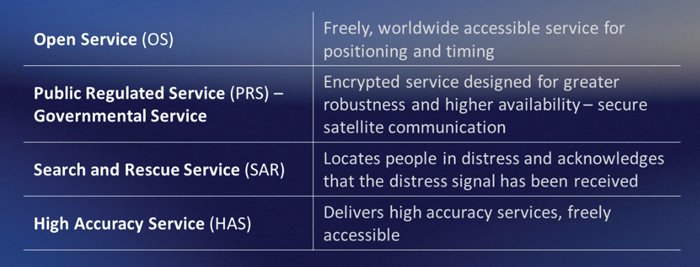
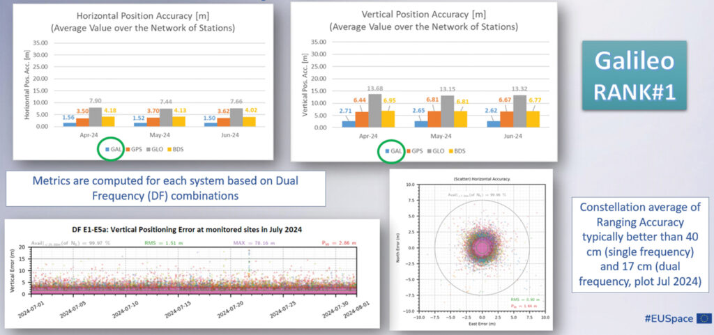
Galileo is Europe’s civil global navigation satellite constellation and a major success of the European Union (EU). It provides the world’s most precise satellite navigation performance. Galileo services began in December 2016 and are currently supplied to more than 3 billion users. They offer several high-performance services worldwide, featuring various levels of accuracy, robustness, authentication and security.
Galileo is a key component of mass-market applications for such areas as transport, agriculture and timing but also for security-critical applications, such as health services, emergency and rescue services and law enforcement. Galileo services continue to expand with many new capabilities that are unique with respect to other GNSS.
The European Union Agency for the Space Programme (EUSPA) and the European Space Agency (ESA) continue to collaborate effectively on the many developments, deployments and evolution activities of the Galileo Programme, each according to their respective responsibilities for exploitation and system development, with the European Commission acting as the program manager.
Stable Service Performance
Galileo services continue to deliver excellent performance every month in a safe, secured and seamless manner, managed by EUSPA. The performance parameters of the Galileo services are independently monitored by the Galileo Reference Centre (GRC) and are regularly published on the web portal of the GNSS Service Centre (GSC): gsc-europa.eu.
The performance of the Open Service (OS) remains “Best in Class” among the GNSS providers. Timing users also continue to receive accurate (in the order of 5 ns) access to Galileo System Time, which they can trace to Universal Coordinated Time (UTC) through the corresponding offset parameters transmitted by the satellites.
The Search and Rescue (SAR) service was delivered well beyond the commitment to the users, for both forward and return link services, while the High Accuracy Service (HAS) and the Public Regulated Service (PRS) continue being provided as planned in the corresponding Service Definition Document (SDD).
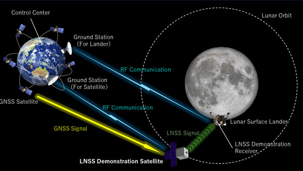
ArkEdge Space, a Japanese space start-up based in Tokyo, has been selected by the Japan Aerospace Exploration Agency (JAXA) under its Space Strategy Fund to lead the development of advanced lunar navigation technology.
Under the agreement, ArkEdge Space will plan and design the mass production and operation of micro-satellite constellations to lead the development of a next-generation Lunar Navigation Satellite System (LNSS), a vital component to the International “LunaNet” initiative driven by National Aeronautics and Space Administration (NASA), European Space Agency (ESA) and JAXA. LunaNet seeks to establish essential infrastructure to support sustainable lunar exploration and foster the growth of the lunar economy.
This program, supported by up to 5 billion yen ($32.5 million) over four years, tasks ArkEdge Space with developing a 100 kg class micro-satellite, developing crucial technology including the:
Lunar navigation payload
Demonstration satellite platform, along with a system operations plan
Establishment of an approach to mission evaluation
These efforts will help reduce development costs and timeframes while advancing core LNSS technologies and enabling the development of future lunar navigation system demonstration satellites, according to ArkEdge Space.
ArkEdge Space’s work on LNSS leverages its expertise in satellite technology and builds on its ongoing collaboration with JAXA. A key innovation of the project involves the use of faint GNSS signals, originally designed for Earth, to determine satellite position and time in lunar orbit—approximately 380,000 km from Earth. Additionally, LNSS complements advancements in low-Earth Orbit positioning navigation and timing (LEO-PNT) systems, designed to provide high-precision, robust navigation services globally, enhancing existing GNSS infrastructure.
As lunar exploration accelerates, high-precision infrastructure has become indispensable for activities such as rover navigation, base construction, and in-situ resource utilization. LNSS supports lunar operations and serves as a stepping stone for future exploration of Mars and deep space.
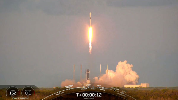
SpaceX has launched the latest pair of Galileo satellites from the Kennedy Space Center in Florida. The SpaceX Falcon 9 rocket carried satellites 31 and 32 (FM26 and FM32) to their designated orbits.
This launch, number 13 in the Galileo program, marks a crucial milestone in the constellation’s development. The addition of these satellites completes the designed constellation, with the required operational satellites plus one spare per orbital plane. The new pair will undergo testing at their final altitude of 23,222 km before becoming operational.
European Space Agency (ESA) Director of Navigation Javier Benedicto highlighted the importance of this launch, stating that the remaining six Galileo First Generation satellites are scheduled for deployment in 2025 and 2026.
These additional satellites are designed to enhance the system’s performance and reliability further, ensuring uninterrupted delivery of highly precise navigation services.
At ION GNSS+ 2024, Eric Châtre, head of EU GNSS exploitation and evolution at the European Commission, and Miguel Manteiga, Galileo project manager at ESA, participated in a panel titled “Status of GPS, Galileo, BDS, QZSS, KPS and NavIC.” They shared how 2024 has been a particularly eventful year for the Galileo program. In April, satellites 29 and 30 were launched and entered service in September. The new Public Regulated Service (PRS) signals began broadcasting, offering encrypted navigation for authorized governmental users. A significant upgrade of Galileo’s ground segment was completed without impacting users.
The Galileo system continues to evolve, with the development of Second Generation (G2) satellites underway. These satellites will feature fully digital navigation payloads, electric propulsion and inter-satellite link capacity.
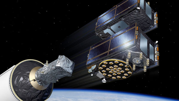
Galileo satellites 29 and 30 have reached their target positions at an altitude of 23,222 km and are now fully operational three months after being launched from Cape Canaveral, Florida, by SpaceX. These new additions to the Galileo constellation are now active and provide navigation signals to users.
Both satellites have been positioned on the same orbital plane, one of three that comprise the Galileo constellation. With this latest addition, two of the three Galileo orbital planes are fully populated, bringing the constellation close to completion. The next Galileo launch is planned in the coming weeks from the Kennedy Space Center in Florida onboard a SpaceX Falcon 9.
The Galileo Service Operator, supported by a team of approximately 30 satellite experts from the European Space Agency (ESA) and satellite manufacturer OHB, conducted early operations at the Galileo Control Centre in Oberpfaffenhofen, Germany, under supervision from the European Union Agency for the Space Programme (EUSPA). Following the initial operations, the satellites entered a drift phase, during which ground teams guided them to their final positions, which was reached on June 24.
On August 21, 2024, ESA, OHB and payload manufacturer SSTL evaluated the in-orbit test results, confirming that the satellites had not experienced any degradation during launch. ESA, in collaboration with EUSPA, then validated the satellites’ performance at the system level.
The combination of advanced technologies for precise orbit determination and timing, as well as the scientific exploitation of GNSS signals, opens major new opportunities for relevant, innovative in-orbit scientific experiments. These opportunities come in the fields of Earth sciences, including geodesy, geophysics and GNSS remote sensing of the atmosphere, land, ocean and ice, fundamental physics, astronomy and time metrology. They could extend some current operational applications such as precise orbit determination for geodesy and altimetry and GNSS radio occultation for meteorology and space weather.
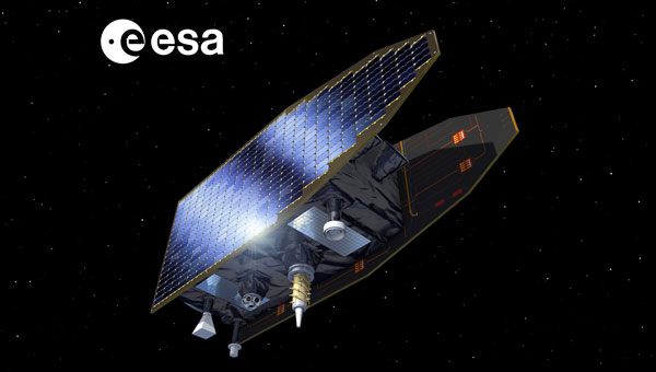
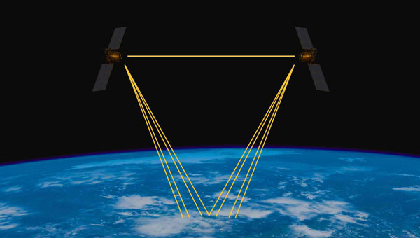
To further enhance the benefits of combining space-based geodetic techniques, the European Space Agency (ESA) has established the Genesis mission. The mission will collocate on board a single well-calibrated satellite, the four space-based geodetic techniques: GNSS, very long baseline interferometry (VLBI), satellite laser ranging (SLR) and Doppler Orbitography and Radio-positioning Integrated by Satellite (DORIS). This first-time-ever collocation in space will establish precise and stable ties among these key techniques. The Genesis satellite will be a unique, dynamic space geodetic observatory, whose observations, combined with the measurements using geodetic collocation techniques stations on Earth, will contribute to a significant improvement of the International Terrestrial Reference Frame (ITRF).
The ITRF is recognized as the foundation for all space- and ground-based observations in Earth science and navigation, and therefore this mission will potentially have a major impact on several GNSS and Earth observation applications. It is a particular realization of the terrestrial reference system, and its history goes back to 1984 when the former Bureau International de l’Heure, which was then in charge of maintaining an accessible reference frame, established a frame using space-based geodetic techniques. The tradition was continued by the International Earth Rotation and Reference Systems Service (IERS) when it was established in 1987. The IERS has periodically updated the ITRF incorporating new systems, data sets and analysis procedures. The Genesis mission will help identify any systematic errors in the ITRF and thereby improve the accuracy and stability of the frame, particularly the origin and scale of the frame, which are the most critical parameters for scientific applications.
The Genesis mission was endorsed by the ESA Ministerial Council in November 2022. The mission will be executed under the responsibility of ESA’s Navigation Directorate as an element of the Future Navigation Program in cooperation with ESA’s Operations Directorate.
ESA performed an internal mission feasibility study (a so-called concurrent design facility) in March and April 2022. A team of more than 40 experts reviewed the mission objectives and the possible implementation, derived high-level mission requirements, assessed the necessary mission instruments and their technology readiness level and concluded that the mission is feasible and compatible with the Genesis-defined program boundaries.
GENESIS MISSION OBJECTIVES
The overall mission goal, as defined by the Global Geodetic Observing System (GGOS) initiative of the International Association of Geodesy, is to help achieve an ITRF accuracy of 1 millimeter with long-term stability of 0.1 millimeters per year, to be able to detect the smallest variations in the Earth system solid, fluid and gaseous components.
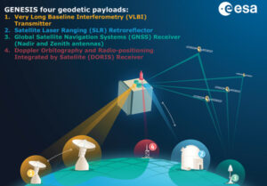
Figure 1: Genesis mission concept.
The improvements of the ITRF will impact and improve multiple geodetic and geophysical observables, as well as precise navigation and positioning, and strengthen the geodetic infrastructure, including the Galileo constellation, by reducing the systematic biases between different observing techniques.
Furthermore, the Genesis mission will allow us to improve the link between the ITRF and the International Celestial Reference Frame (ICRF) due to improvement in determining the Earth orientation parameters (EOPs). The ICRF is a realization of a quasi-inertial reference system defined by extragalactic radio sources, mostly quasars, billions of light years away. The positions of a set of globally distributed VLBI radio telescopes are determined using the difference in the arrival times of the signals at the different telescopes. The ICRF was established and is maintained through a cooperation between the International Astronomical Union and the IERS.
The ITRF and the ICRF are related through the EOPs, which include pole coordinates, the Earth’s rotation angle typically referred to as Universal Time (and the related length of day), and nutation angles and their rates.
GENESIS MISSION OVERVIEW
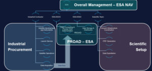
Figure 2 Genesis project organization.
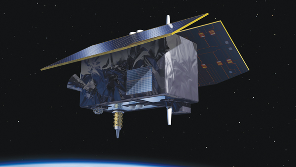
The baseline orbit of the Genesis satellite will be circular, will have an altitude of about 6,000 kilometers and an inclination of about 95 degrees. The mass of the satellite will be on the order of 250 kilograms to 300 kilogramsg, and it will have very precise on-board metrology, through a single ultra-stable oscillator. An artist’s conception of the satellite in space is shown in the opening image. The launch is foreseen for 2028, and the baseline duration for operations is two years with an option for extension.
The Genesis mission architecture will consist of the Genesis satellite, a ground control segment constituted by a mission control center and a (network of) ground station(s), a data processing center (including a global GNSS sensor station network), a data archiving and distribution center, and the required ground infrastructure for the VLBI, SLR and DORIS campaigns (See FIGURE 1). The scope of the procurement for this mission is the Genesis satellite, the ground control segment, the launch service and two years of operations with the option for extension.
As previously mentioned, the satellite will be launched as the first with all four space-based geodetic techniques on board — namely GNSS, VLBI, SLR and DORIS:
GNSS receiver. This will be a high-quality multi-constellation (Galileo and GPS) and multi-frequency space receiver. The GNSS observations will be of very high quality and will allow multi-GNSS integer ambiguity resolution for the carrier phase with a very high success rate. This instrument is crucial for the very precise orbit determination of the Genesis satellite.
VLBI. This instrument will transmit radio signals compatible with receivers at each observing VLBI station. To eliminate the ionospheric dispersive delay along the paths to each station, different frequency bands will be used. The signals will also comply with the evolving observation procedures at all VLBI stations. The signals will be observed by all geodetic VLBI antennas, including the new VLBI Global Observing System (VGOS) fast slewing stations, in their standard geodetic receiver setups. The transmitter currently under development is designed to transmit at different frequencies between 2 GHz and 14 GHz, but also higher frequency bands can be considered. The present setup for regular VGOS observations use four 1-GHz-wide bands within the S, C and X frequency bands. The unit is designed to transmit both pseudo-noise and random noise. The random noise signal mimics the broader-band noise emitted by quasar radio sources routinely observed by VLBI, and hence can be processed essentially by the usual station and correlator software. VLBI observations of Genesis will enable VLBI stations to be accurately located within the ITRF consistently with the other geodetic techniques, enable a frame tie between the celestial frame and the dynamic reference frames of satellite orbits as well as a frame tie between the ITRF and the extremely accurate and stable ICRF.
SLR. A passive SLR retro-reflector (LRR) will be attached to the satellite in such a way to ensure an adequate field of view when the satellite is in Earth-pointing mode. The SLR observable is the round-trip time of flight of a laser pulse between a ground station and the LLR. Currently, the ITRF long-term origin is defined by SLR, and this is the most accurate satellite technique in sensing the Earth’s center of mass.
DORIS. Genesis will include a DORIS receiver instrument. DORIS is based on the principle of the Doppler effect between a network of transmitting terrestrial beacons and the on-board instrument. DORIS was first featured on the SPOT-2 satellite launched in 1990. Since then, DORIS receivers have been featured on multiple satellites. The integration of the DORIS receiver on Genesis, given the high-precision knowledge of the Genesis orbit, will benefit other space geodetic techniques from the global DORIS network distribution.
All active instruments will rely on a single high-precision compact frequency standard payload, termed the ultra-stable oscillator.
GENESIS PROJECT ORGANIZATION
The Genesis mission is being procured in an end-to-end approach, meaning that the industry prime is responsible for the development of the satellite, including the payload instruments, the launch services and the satellite operations. For this reason, the following approach has been applied: contract signature was in March 2024. Design, development, validation and acceptance will take place between 2024 and 2027, leading up to a planned launch in 2028.
The contract for Genesis amounts to € 76.6 million. A consortium of 14 entities led by OHB Italia S.p.A. has been tasked with developing, manufacturing, qualifying, calibrating, launching and operating the Genesis satellite, including all its payloads. The mission is supported by Italy, Belgium, France, Switzerland, Hungary and the United Kingdom.
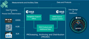
Figure 3 Processing, archiving and distribution of Genesis data and products.
The overall project organization is outlined in FIGURE 2. The ESA Genesis project team, led by the project manager, will manage and coordinate the work of all interfaces among i) the industrial consortium, ii) ESA in its role of handling data processing, archiving and operating the distribution center, iii) the scientific community for whatever the necessary interface is required for the preparation of scientific exploitation and coherency between the project development and the scientific mission objectives.
For the data processing, exploitation, archiving and dissemination of data to the scientific community, the PROcessing, Archiving, exploitation and Dissemination Centre (PROAD) has been set up, (See FIGURE 3), using the European Space Operations Centre (ESOC) Navigation Support Office facilities and the GNSS Science Support Centre (GSSC) of the European Space Astronomy Centre (ESAC).
For the data processing required in advance of scientific exploitation of the data, the ESOC Navigation Support Office facilities will be used. The data processing includes the precise orbit determination for the GENESIS satellite.
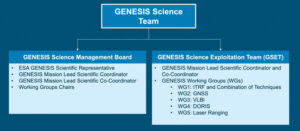
Figure 4 Genesis science team.
Furthermore, after the processing performed by ESOC, ESAC’s GSSC will be used for data archiving and data distribution for scientific exploitation. The PROAD will be set up and coordinated internally in ESA.
The setup and coordination of the required ground infrastructure, VLBI and SLR campaigns, the DORIS network and so on, will be managed by ESA’s Genesis project team together with a Genesis science team (See FIGURE 4).
The science team will also support ESA’s Genesis project team as required in the reviews and follow-up activities, especially with respect to compliance with the mission objectives.
SUMMARY
The Genesis mission is a very challenging one, which has been made possible by the combined effort from the scientific community, ESA member states, industry and ESA itself. The success of Genesis will strongly depend on the interaction, cooperation and support of the international scientific community. The mission objectives of Genesis address core scientific as well as societal aspects. Above all, the Genesis mission is at the foundation level of all positioning and navigation.
ACKNOWLEDGEMENTS
This article has drawn, in part, on the multi-author paper “GENESIS: co-location of geodetic techniques in space,” Earth, Planets and Space (2023), Vol. 75, No. 5, https://doi.org/10.1186/s40623-022-01752-w