Tag: ESA

  • ESA’s HydroGNSS satellites launched to scout for water

    ESA’s HydroGNSS satellites launched to scout for water

    The European Space Agency’s first Scout mission, HydroGNSS, was launched Nov. 28, marking a significant step in advancing global understanding of water availability and the effects of climate change on Earth’s water cycle.

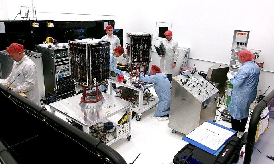
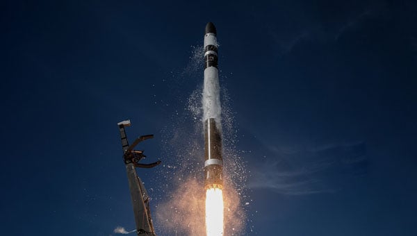
    The two twin HydroGNSS satellites were carried into orbit at 19:44 CET aboard a SpaceX Falcon 9 rocket, as part of the Transporter-15 rideshare flight from the Vandenberg Space Force Base in California.

    Less than 90 minutes after liftoff, the two satellites separated from the rocket. Then, at 22:45 CET, Surrey Satellite Technology Ltd. (SSTL) in the UK confirmed that they had received signals, indicating that both satellites were safely in orbit around Earth.

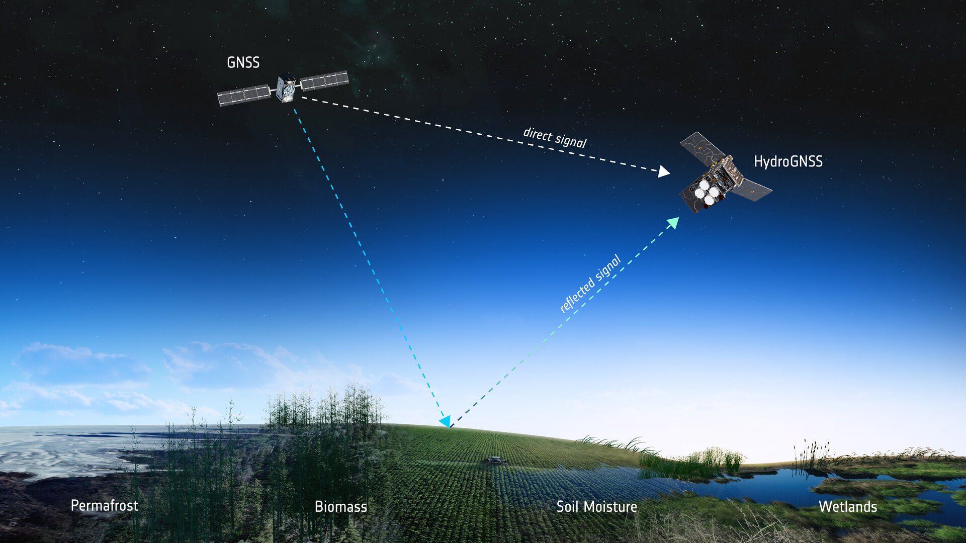
    How GNSS reflectometry helps

    Both satellites use GNSS reflectometry to scout for water by capturing L-band signals from navigation systems such as GPS and Galileo. These navigation satellites transmit L-band microwave signals that change when they are reflected off Earth’s surface.

    The HydroGNSS satellites then compare these reflected signals with the signals the satellites receive directly from the GNSS satellites to reveal valuable information about the properties related to the water cycle, and more.

    To do this, each HydroGNSS satellite carries a delay doppler mapping receiver and two antennas. A zenith antenna tracks direct GNSS signals and a nadir antenna collects reflected signals and processes them into delay Doppler maps.

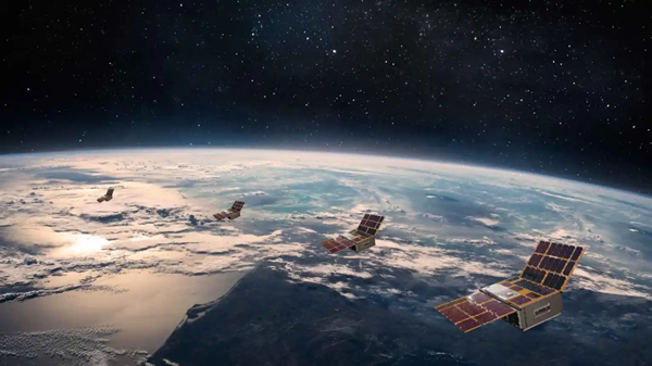
    Using this technique, the two small satellites, which orbit Earth 180 degrees apart, will measure soil moisture, freeze-thaw state, inundation and above-ground biomass.

    Understanding the water cycle

    The data will not only be vital for advancing our understanding of Earth’s water cycle, but also for supporting applications such as flood prediction and agricultural planning.

    Also, by observing the extent of inundation and areas of wetland, HydroGNSS will help reveal wetlands – important ecosystems that can act as significant sources of methane – often hidden beneath forest canopies.

    Information on freeze–thaw states will provide insight into the surface radiation balance, energy and carbon exchanges with the atmosphere, and the behaviour of subsurface permafrost in high latitudes.

    Meanwhile, data on above-ground biomass will contribute to estimates of forest carbon stocks and their role in the global carbon cycle.

    More Scouts to come

    The Scout satellite missions harness small, smart satellites to shrink proven technologies or test bold new ways of observing the planet. Each mission races from concept to launch in three years, on a lean budget of €35 million that covers everything from design and construction to in-orbit operations.

    “As the first of ESA’s Scout missions to launch, HydroGNSS marks an important milestone for this new family of rapid, low-cost Earth observation missions, and we extend our thanks to the mission’s prime contractor, SSTL,” said Simonetta Cheli, ESA’s director of Earth Observation Programmes. “The launch also represents a key step in the evolution of our FutureEO programme, where the Scouts embody a fast, agile, innovative and cost-efficient approach – complementing our larger Earth Explorer research missions.

    “We now look forward to seeing how HydroGNSS will employ GNSS reflectometry to deliver valuable insights into key hydrological variables that shape Earth’s water cycle,” Cheli said.

    ESA’s prime contractor for the HydroGNSS mission is SSTL in the UK. SSTL is also responsible for operating the satellites in orbit and for distributing the data. The mission is also thanks to partial funding from the UK Space Agency.

  • ESA’s HydroGNSS Scout satellites ready for launch

    ESA’s HydroGNSS Scout satellites ready for launch

    Two European Space Agency (ESA) microsatellites will soon be launched to study climate variables linked to water using GNSS reflectometry. The twin HydroGNSS satellites arrived at Vandenberg Space Force Base in California at the end of September, from where they will be launched later this month.

    The HydroGNSS twins are the European Space Agency’s first Scout venture, part of the agency’s Earth Observation FutureEO programme. Scout missions are designed to deliver cutting-edge science quickly and affordably, complementing ESA’s larger Earth Explorer missions.

    The identical microsatellites will launch from Vandenberg aboard a SpaceX Falcon 9 rocket, sharing their Transporter-15 ride into orbit with several other small satellites.

    Since their arrival, the HydroGNSS satellites have undergone a series of final checks — including testing, propellant loading, battery charging and integration with their launch adapter. Both satellites are now ready for closing of the rocket fairing.

    Once in orbit, the two satellites will travel 180 degrees apart around Earth to maximize coverage.

    The mission focuses on four crucial variables, all recognized as “essential climate variables” or closely related to them: soil moisture, freeze–thaw state over permafrost, inundation and above-ground biomass. These data are vital for improving our understanding of Earth’s water cycle, including wetlands, permafrost dynamics and forest carbon storage. The data will aid in agricultural planning, flood prediction, and others areas.

    HydroGNSS satellites will use GNSS reflectometry to measure key hydrological climate variables, including soil moisture, freeze–thaw state over permafrost, inundation and wetlands, and above-ground biomass. (Image: ESA)
    HydroGNSS satellites will use GNSS reflectometry to measure key hydrological climate variables, including soil moisture, freeze–thaw state over permafrost, inundation and wetlands, and above-ground biomass. (Image: ESA)

    Navigation satellites such as GPS and Galileo transmit L-band microwave signals that change when reflected off Earth’s surface. HydroGNSS will compare these reflected signals with the direct GNSS signals to extract valuable information about geophysical parameters related to the water cycle.

    New Space missions. Inspired by the principles of New Space, the Scout programme emphasises agility and innovation — using small satellites to miniaturise proven technologies or demonstrate entirely new ways of observing Earth.

    Each Scout mission must move from kick-off to launch within just three years and under a budget of €35 million, covering everything from satellite development to in-orbit commissioning. The resulting data are provided as a service to the scientific community and ESA, helping accelerate our understanding of the planet.

  • All.Space awarded €950,000 by ESA’s NAVISP for GNSS-independent tech

    All.Space awarded €950,000 by ESA’s NAVISP for GNSS-independent tech

    All.Space, a provider of multi-orbit, multi-link satcom omplatforms, has been awarded €950,000 by the European Space Agency’s Navigation Innovation and Support Programme (NAVISP). The award is to develop an alternative position, navigation and timing (PNT) capability designed to operate in GNSS-denied environments.

    The project will build a proof of concept for alternative PNT, harnessing All.Space’s multi-orbit terminal technology to generate and analyze signals of opportunity that can deliver position and orientation data independently from traditional GNSS sources.

    The technology is designed to counter rising threats from GNSS jamming and spoofing – scenarios of increasing concern for both defence and commercial operators. Delivered in partnership with UK-based GNSS experts GMV NSL, the project is aimed at embedding a resilient PNT capability directly within the All.Space terminal, forming part of its growing software as a service (SaaS) portfolio.

    “GNSS denial is no longer a hypothetical scenario,” said Paul McCarter, CEO at All.Space. “It’s a growing reality. With this project we’re developing a sovereign alternative that can restore confidence, capability and control in even the most contested environments.”

    Once proven, the technology will be matured and commercialized as an integrated service offering, helping customers achieve operational independence and secure navigation in any domain.

    ESA’s NAVISP programme is designed to spur innovation in navigation technologies and services across its Member States.

  • FreeGNSSNetwork: Sateliot launches project with ESA to break GNSS dependency

    FreeGNSSNetwork: Sateliot launches project with ESA to break GNSS dependency

    Sateliot, a leading satellite telecommunications operator in 5G IoT connectivity, will test a pioneering system that allows its satellites to connect with IoT devices without relying on GNSS. The breakthrough opens new opportunities in sectors such as defense and security, where Europe’s technological autonomy and operation in GNSS-denied environments are strategic priorities.

    Low-Earth orbit (LEO) satellite constellations, such as the one developed by Sateliot, provide coverage in areas beyond the reach of terrestrial networks — over half of the planet’s surface. However, until now, they depended on GNSS, increasing both the energy consumption of devices and terminal costs.

    The FreeGNSSNetwork project, signed with the European Space Agency (ESA) and led jointly with GMV, eliminates this dependency using advanced algorithms that enable devices to calculate their position directly from the satellites’ signals. This maintains a stable and accurate connection even under complex conditions such as wartime scenarios.

    According to the company, this project represents a paradigm shift and lays the groundwork for developing 6G technology, in which Sateliot actively contributes within the 3GPP framework.

    The FreeGNSSNetwork enables device positioning with an accuracy of approximately 10 meters and provides extremely precise time synchronization services of 50 nanoseconds, the equivalent of 0.00000005 seconds.

    The system is being tested in laboratories that replicate real satellite communication conditions and will be demonstrated in orbit with prototype satellites and terminals, sending positioning, navigation, and timing (PNT) data directly to IoT devices.

  • ESA honors Rohde & Schwarz for contributions to satellite navigation over 30 years

    ESA honors Rohde & Schwarz for contributions to satellite navigation over 30 years

    The European Space Agency (ESA) marked 30 years of European satellite navigation with a celebration Sep. 2 at its research and technology center. The event honored key contributors who have shaped the journey of systems like Galileo and EGNOS, which have positioned Europe as a global leader in satellite navigation.

    Among the honorees was Rohde & Schwarz, recognized for the excellence, commitment and long-standing partnership leading to the success of European satellite navigation programs over the past three decades.

    Javier Benedicto kicks off the celebration of 30 years of satellite navigation. (Photo: ESA)
    Javier Benedicto kicks off the celebration of 30 years of satellite navigation. (Photo: ESA)

    The event brought together institutional and industrial partners, ESA Member State representatives, and leading figures in satellite navigation. The celebration revisited pivotal milestones in Europe’s satellite navigation history and looked ahead to future innovations.

    A highlight of the evening was the award ceremony led by ESA Director of Navigation Javier Benedicto, who, alongside past directors, presented accolades to organizations and partners instrumental in this success story.

    Rohde & Schwarz’s recognition underscores their role in advancing European satellite navigation technology. Their contributions have been vital in the development and operational success of Galileo and EGNOS, systems that have revolutionized positioning, navigation, and timing services across Europe and beyond.

    The event not only celebrated past achievements but also set the stage for the future of European satellite navigation, with discussions around upcoming initiatives and advancements. For Rohde & Schwarz and other honourees, the evening served as both a celebration of past achievements and a call to continue building a connected, resilient, and sustainable future in space.

    “Thirty years of satellite navigation is a testament to shared vision, determination to push technology boundaries, and intense, long-term collaboration,” said Rob Short, director of Business Development at Rohde & Schwarz. “We are honoured to have contributed to this remarkable achievement. Congratulations to everyone who made this milestone possible.”

  • ESA fights interference in Arctic tests

    ESA fights interference in Arctic tests

    News from the European Space Agency

    In its pursuit of strengthening European resilience in navigation, the European Space Agency (ESA) took part in Jammertest. Jammertest 2025 brought together 360 participants from 120 organisations across more than 20 countries, spanning academia, industry and governmental institutions.

    Incidents of deliberate GNSS interference are on the rise, wih attacks happening daily worldwide. Disruptions threaten safe operations of energy grids, banking infrastructure, emergency transportation and civil aviation, with an outage potentially costing billions of euros daily for Europe.

    Bleik on the island of Andøya offered a suitable setting for Jammerfest. (Image: ESA)
    Bleik on the island of Andøya offered a suitable setting for Jammerfest. (Image: ESA)

    Jammertest. In a complex coordination exercise among seven Norwegian public authorities and facilitator Testnor, Jammertest organisers broadcast real satellite navigation interference for participants to observe how their equipment (on vehicles, drones, aircrafts, helicopters and vessels responds.

    At nearly 70 degrees North and 300 km inside the Arctic Circle, the small village of Bleik on the island of Andøya offers the ideal setting for Jammertest. To the east, towering mountains act as natural barriers that contain disruptive signals, minimising their impact on civil society. To the west, its open coastline allows signals to be transmitted over the sea, supporting maritime participants in addition to air and land users.

    The event’s test catalogue is extensive. Organisers simulate everything from simple handheld jamming to complex multi-source attacks launched from several locations simultaneously, including from mountaintops. “The goal is that every receiver is knocked out at some point during the campaign,” explains Tomas Levin, senior principal engineer at Norwegian Public Roads Administration and head of Jammertest.

    “At Jammertest, the full GNSS chain sits along a table, from chip manufacturers to those developing the algorithms that run on them, to the companies building products around those chips and the ones integrating these products into larger systems,” Levin said.

    Photo:
    ESA’s navigation and telecommunications testbed vehicles are custom-built mobile test platforms operated by ESA’s Navigation Laboratory to support test campaigns for navigation and telecommunications services, most notably Europe’s Galileo constellation. (Photo: ESA)

    ESA engineers arrived with several missions. As in previous years, the team tested the robustness of EGNOS and Galileo signals when picked by a range of antennas, from simple mass-market ones found in smartphones to military-grade antennas, both stationary and mounted on a moving van.

    A key objective was to test the performance of novel receiver technologies developed under various ESA programs, comparing them to current technologies. The team also tested equipment provided by industrial partners under ESA’s Third-Party services.

    More than 100 TB of data were recorded and will support internal research. Moreover, these data can now be replayed at the ESA Navigation Laboratory, allowing industry to analyse how new equipment responds to real-world interference scenarios. (If you are interested in using ESA’s NavLab testing and consultancy services, fill out the contact form on the Consultancy and Testing page).

    Finally, ESA also oversaw tests of new EGNOS ground receivers being developed by European industry under Horizon2020 and Horizon Europe programmes. These receivers aim to improve the system’s robustness in its next generation.

    Multi-beam satellite navigation antenna test. (Photo: ESA)
    A multi-beam satellite navigation antenna test. (Photo: ESA)

    Several projects tested at Jammertest by other participants were funded through NAVISP, highlighting the agency’s role in fostering innovation across the GNSS ecosystem. 

    “Jammertest is a unique opportunity,” concludes Derambure. “Here we have the edge of technology, the edge of testing scenarios. There is nowhere else where we can test this material in real conditions. I believe Jammertest will become a mandatory step for any new satellite navigation receiver technology.” 

  • Spain’s PLD Space to develop GNSS-IMU for reusable space vehicles

    Spain’s PLD Space to develop GNSS-IMU for reusable space vehicles

    PLD Space, based in Elche, Spain, has been selected by the European Space Research and Technology Centre (ESTEC) for its first Guidance, Navigation and Control (GNC) contract. Under this contract, the company will develop HALCON (Hybridization Algorithms and Low-cost Components for Optimized Navigation), a new hybrid navigation software for reusable launch vehicles. 

    ESTEC is part of the European Space Agency (ESA). The project has been approved under NAVISP Element 2, a key ESA initiative to enhance European competitiveness in positioning, navigation and Timing (PNT) technologies.

    The contract, with a total budget of €995,705, will be co-funded equally by ESA and PLD Space, which will retain ownership of the final development. 

    GNSS-IMU System for Reusability

    The HALCON project aims to develop advanced software that combines inertial measurement unit (IMU) data with GNSS signals to achieve precise navigation during rocket launch and landing, a critical capability for reusable launchers such as MIURA 5 and MIURA Next. 

    Traditionally, IMU-only systems have been costly, less accessible, and less accurate over long operational periods. By integrating GNSS signals (such as Galileo or GPS), PLD Space will develop its own, more affordable and more precise navigation system, optimized for controlled landings — an essential step towards advancing the reusability of space vehicles. 

    Image: PLD Space
    Image: PLD Space

    “This project represents a strategic step forward in the development of our own navigation capabilities,” said Raúl Verdú, co-founder and chief business development officer of PLD Space. “With ESA’s support, we will enhance landing maneuver precision, gain vertical integration, and move towards the future integration of autonomous flight termination technologies in Europe.”

    The proposal was selected under ESA’s NAVISP Spanish Call, launched in November 2024, arranged both by the Spanish Space Agency (AEE) and ESA. The call invited Spanish industry to propose innovative projects in the PNT field. PLD Space’s contract follows a rigorous technical and commercial assessment and has been favorably evaluated for its alignment with market demand, the competitiveness of the solution, and the strength of its commercialization strategy. 

    Technology for Europe’s Future in Space 

    The HALCON system will deliver centimeter-level positioning accuracy, enhancing both safety and operational efficiency. It is based on commercial off-the-shelf (COTS) components, significantly reducing development costs compared to traditional high-end solutions. 

    This technology will not only improve the reliability and sustainability of space transportation but will also pave the way for future capabilities such as a European Autonomous Flight Termination System (AFTS), which is not yet authorized on the continent. This capability is critical for increasing flight autonomy and mission safety in complex scenarios, while positioning Spain as a leader in next-generation launchers. 

    The development will be carried out entirely in-house by PLD Space’s engineering team, with ESA’s technical support, and will be integrated into the company’s technology roadmap, aligned with its reusability and operational autonomy plans through 2030. 

  • ESA’s Celeste LEO-PNT demonstrator mission set to launch in December

    ESA’s Celeste LEO-PNT demonstrator mission set to launch in December

    The European Space Agency (ESA) has confirmed plans to launch the first two satellites in its low-Earth orbit (LEO) positioning navigation and timing (PNT) constellation in the second half of December 2025. The launch will use a Rocket Lab Electron Vehicle, marking Europe’s first venture into LEO-based satellite navigation.

    The LEO-PNT in-orbit demonstrator mission, called Celeste, aims to test satellite navigation capabilities in LEO and evaluate its integration with existing medium-Earth orbit (MEO) systems.

    Celeste features a constellation of ten satellites that will fly close to Earth to test innovative signals across various frequency bands. The first two Celeste satellites, built in parallel by GMV and Thales Alenia Space, are set to launch in the coming months.

    The dedicated Electron rocket launch will place both satellites in orbit at 510 km altitude. The launch window extends for three months beginning in mid-December 2025, with operations conducted from Rocket Lab’s New Zealand facility.

    ESA Director of Navigation, Javier Benedicto, said, “We are thrilled to see the LEO-PNT demonstration advancing so quickly, with less than two years between mission kick-off and launch. This launch ensures the first European LEO-PNT satellites are in space before spring 2026, crucial for bringing the frequencies into use in compliance with the International Telecommunications Union.”

    Galileo’s “Daughter Mission”

    The name Celeste pays homage to Maria Celeste, Galileo Galilei’s daughter, as the two shared a strong emotional and intellectual bond, with the daughter honoring her father’s astronomical interest. This symbolic connection links the pioneering work of the father of modern astronomy to contemporary navigation systems, with Celeste serving as a bridge between Galileo’s groundbreaking discoveries and today’s satellite-based positioning technology.

    The demonstrator satellites for Galileo, launched in 2005 and 2008, were called GIOVE, after the Italian word for Jupiter. This name also paid tribute to Galileo’s achievements in discovering the planet’s four largest Moons which were used to determine longitude from anywhere on Earth.

    System Advantages

    The initial Pathfinder A satellites are CubeSats measuring 12U and 16U formats, comparable to suitcase size and weighing approximately 20 kg to 30 kg. These satellites will broadcast in L-band and S-band frequencies and operate for at least six months following orbital commissioning.

    The larger, more complex Pathfinder B satellites will follow, incorporating additional payloads to test innovative signals across multiple frequency bands and demonstrate expanded services.

    LEO-PNT satellites will supplement existing GNSS constellations by providing enhanced coverage in challenging environments. The system aims to improve navigation services in deep urban areas, under heavy foliage, in polar regions and potentially indoor locations where current MEO satellites face limitations.

    The complete demonstrator constellation, expected to be operational by 2027, will assess how LEO navigation systems can integrate with existing GNSS infrastructure. The mission will also test interoperability with 5G and 6G communication standards.

    Preparing for Launch

    Satellite integration and testing of Pathfinder A hardware and software continues ahead of the December launch. ESA and industrial teams plan to complete testing during summer 2025, with qualification and acceptance reviews scheduled for autumn.

    “Pathfinder A satellites have already paid off, even before launch,” said Roberto Prieto-Cerdeira, ESA’S LEO-PNT project manager. “The experience gathered during their development is helping to identify critical technologies, system design trade-offs, design choices and optimised approaches and processes, paving the way for future phases of LEO-PNT. Having them in orbit and validating their signals and algorithms is a major additional achievement.”

    Future Plans

    Following the demonstrator mission, ESA plans to propose an in-orbit preparatory phase at the agency’s November Ministerial Council meeting. This phase would focus on technology development and industrialization, potentially leading to an operational system integrated with EU GNSS infrastructure.

    The Celeste demonstrator is part of FutureNAV, an ESA Navigation program designed to maintain Europe’s position at the forefront of satellite navigation technology.

    The mission receives backing from 15 ESA member states: Austria, Belgium, Finland, France, Germany, Hungary, Italy, Norway, Poland, Portugal, Romania, Spain, Sweden, Switzerland and the United Kingdom. More than 50 entities from 14 countries participate in the two development consortia awarded contracts in 2024.

  • GMV to develop collision avoidance service for LEO constellations

    GMV to develop collision avoidance service for LEO constellations

    The rapid growth of satellite constellations in low-Earth orbit (LEO), the risk of orbital collisions is rising at an unprecedented rate. The increasing amount of space debris — ranging from active satellites to defunct assets and debris — poses serious challenges for operators striving to maintain the safety and sustainability of their missions. As daily data volumes grow and conjunction warnings become more frequent, the space community faces pressure to adopt more advanced and reliable collision avoidance solutions.

    In response to these growing challenges, the European Space Agency (ESA) has awarded GMV a research and development contract under the ARTES Core Competitiveness program, aimed at improving collision avoidance services for large telecommunications constellations. The initiative will focus on developing advanced capabilities for FOCUSOC NXTGEN, a platform designed to deliver faster and more accurate collision risk assessments by using diverse data sources and enhanced response strategies.

    As part of the project, a conjunction assessment center will be established in the United Kingdom to expand support for satellite operators both domestically and internationally. The new system architecture aims to handle higher volumes of data and provide scalable performance to match the needs of next-generation constellations, potentially exceeding 1,000 satellites per constellation.

    FOCUSOC NXTGEN incorporates several features, including a dedicated database for trend analysis, a maneuver testing environment grounded in flight dynamics, API integration for efficient operations, and a redundant infrastructure to ensure continuous service availability. The system seeks to filter out false positives from daily orbital data, identify genuine threats more accurately, and deliver timely recommendations to operators for effective maneuver planning.

    The service is set for launch in summer 2026 in coordination with industry partners. ESA officials note that enhancing orbital collision avoidance technologies will be crucial to maintaining safe and sustainable operations as satellite numbers continue to rise.

    ESA’s ARTES Core Competitiveness program provides funding and expertise to strengthen the satellite communications sector across Europe and Canada. The program supports both technology development and efforts to bring innovative products and services to market.

  • ESA and Neuraspace work to minimize signal noise through GNSS advances

    ESA and Neuraspace work to minimize signal noise through GNSS advances

    Neuraspace is working with the European Space Agency (ESA) to use innovative GNSS technologies to minimize signal noise under a new NAVISP project. Neuraspace is an expert in space domain awareness (SDA) solutions,

    “Stop Getting Noise – Automated GNSS Processing for Smarter Orbits” (NAVISP Element 2) seeks to address critical operational challenges faced by commercial satellite operators, launch service providers and defense and government agencies.

    Challenges to be addressed include the urgent need for more scalable, accurate and autonomous orbit determination, particularly for satellite mega-constellations, in an increasingly congested space environment. While defense and government agencies demand high-confidence SDA solutions amid increasing geopolitical tensions, satellite operators require reliable orbit tracking and early mission support.

    The result is expected to use innovative GNSS technologies to reduce the risk of satellite collisions and enable satellite operators to make faster and more accurate decisions about safekeeping their assets. Solutions will also lead to more efficient operations with lesser reliance on ground infrastructure and smarter fuel management translating into lower mission costs.

    In particular, the project includes:

    • GNSS Data Cleanup to remove biases and noise to improve the precision of orbit determination.
    • GNSS Orbital Phase Correction by introducing lightweight onboard algorithms designed to run on resource-constrained satellite systems. The algorithms will use real-time data to enable satellites to autonomously correct trajectory predictions and minimize reliance on ground stations, saving time and resources.
    • GNSS Orbit Determination Accuracy to provide better orbit predictions by developing advanced methodologies to deliver critical positioning information for safe operations and maneuver planning.
  • Rocket Lab to launch ESA’s first LEO-PNT navigation satellites

    Rocket Lab to launch ESA’s first LEO-PNT navigation satellites

    The European Space Agency (ESA) has selected Rocket Lab Corporation to launch a dedicated Electron mission, marking the first time the company will deploy satellites for ESA’s next-generation navigation constellation, low-Earth orbit positioning, navigation and timing (LEO-PNT). Thales Alenia Space and GMV, two European satellite prime contractors, are providing the “Pathfinder A” spacecraft for the mission. Rocket Lab plans to launch the satellites from Launch Complex 1 no earlier than December 2025.

    The mission will place the two satellites in a 510 km LEO to test a new method of delivering location, direction and timing services from satellites in low orbit, known as LEO-PNT. ESA will use this demonstration to evaluate how a low Earth orbit satellite fleet can work with the Galileo and EGNOS constellations, which provide Europe’s global navigation system from higher orbits.

    This contract highlights Rocket Lab’s growing role as a launch provider for European constellation operators and demonstrates the Electron rocket’s strong reputation. Earlier this year, Rocket Lab deployed a full constellation of IoT satellites for French operator Kinéis and launched a global wildfire detection mission for Germany-based OroraTech. Since 2021, Rocket Lab has supported European satellite operators with Electron missions

  • ESA teams up with Leonardo against satnav jamming

    ESA teams up with Leonardo against satnav jamming

    The European Space Agency (ESA) and Leonardo are embarking on a joint project to explore smart antennas powered by machine learning to block unwanted signals.

    Representatives of ESA and Leonardo signed a contract at the Paris Air Show to research and develop machine learning techniques to steer antenna arrays to block out unwanted signals. The project will be developed under the umbrella of ESA’s Navigation Innovation Support Programme (NAVISP).

    Smarter antenna designs for resilience

    Conventional antennas catch signals from all directions. A controlled reception pattern antenna (CRPA) can focus on signals coming from specific satellites and ignore signals or interference coming from other directions. These types of antennas are used in satellite navigation receivers to block jamming and counterfeit signals. They rely on electronics that control how they adjust their patterns (beamforming).

    Under contract with NAVISP, Leonardo — together with ELT Group as subcontractor — will explore the reduction of the distance between the antenna elements to reduce the size and weight of the antenna array, and the use of machine learning to determine the best antenna setup and adjust the settings faster. This approach will lead to smaller, smarter and more effective antennas, especially useful in space-limited environments such as aircraft.

    The project covers identification of the smarter algorithm for signal blocking, building and testing a real-time receiver demonstrator based on the selected algorithm, and comparing it to conventional larger antennas. The aim is to reach a Technology Readiness Level (TRL) of 4, delivering a lab-tested technology by the end of the project, in two years.