Tag: ESA

  • Honeywell Tracking Passes Test for Galileo Search and Rescue

    Honeywell Tracking Passes Test for Galileo Search and Rescue

    One of the Honeywell Global Tracking ESA installations.
    One of the Honeywell Global Tracking ESA installations.

    Honeywell’s Global Tracking solution has passed the final acceptance test for use on the European Space Agency’s (ESA) Galileo search and rescue program by demonstrating dramatically reduced emergency response times, Honeywell said.

    Honeywell Global Tracking, part of Honeywell’s Scanning and Mobility business, is working in partnership with the Aerospace & Defense division of Capgemini, the prime contractor for the Galileo search and rescue program, to deliver a high-precision positioning system that is fully compatible with the international standard, which is known as the Cospas-Sarsat standard. Tests using the Honeywell system have proven that the time from beacon transmission to detection and processing has been reduced from several hours to a few minutes — often the difference between life and death in an emergency situation.

    The international Cospas-Sarsat program is a satellite-based search and rescue distress alert detection and information distribution system, best known for detecting and locating emergency beacons activated by aircraft, ships and remotely located people in distress. Honeywell’s satellite tracking technology, which detects faint alerts sent by emergency beacons around the world using a combination of Doppler curves, noise reduction, and advanced signal processing, quickly calculates the exact location of the beacon and sends the results to the relevant Mission Control Centers in the region.

    “Our Medium Earth Orbit-based search and rescue solution will lead to faster recovery missions and improved international search and rescue operations, and we’re pleased to partner with the European Space Agency to help execute on this important, life-saving system,” said David Sharratt, general manager, Honeywell Global Tracking. “With decades of experience developing this technology, Honeywell Global Tracking is the global leader of search and rescue solutions.”

    “Up until now, Cospas-Sarsat has relied on satellites in low and high orbits, but medium orbits with satellites such as Galileo are better for search and rescue purposes; they combine a wide field of view with strong Doppler shift, making it more likely a distress signal is pinpointed promptly and accurately,” said Fermin Alvarez, ground station and fielding engineer with ESA. “Together with Honeywell, we are encouraged to see Galileo performing so strongly, thereby solidifying our ability to support precise and speedy search and rescue efforts.”

  • Galileo NAGU Announces Completion of Ground Upgrade

    News courtesy of CANSPACE Listserv.

    The European GNSS Service Centre has issued Notice Advisories to Galileo Users announcing the completion of a ground segment upgrade and system testing as of 1 April 2015. The three fully operational Galileo satellites (GSAT0101, GSAT0102, and GSAT0103) have been declared available from 1 April 2015 at 00:00 UTC.

    • GSAT0101 (ID:11) payload on PHM clock
    • GSAT0102 (ID:12) payload on RAFS clock
    • GSAT0103 (ID:19) payload on PHM clock
    • GSAT0104 (ID:20) is still considered unavailable as it only transmits an E1 signal.
    • GSAT0201 (ID:18) and GSAT0202 (ID:14), although now in improved orbits, have not been declared available.

    Meanwhile, the two recently launched satellites (GSAT0203 and GSAT0204) are slowly drifting to their assigned orbits. They are not yet transmitting standard L-band signals.

    Read more about the upgrade here.

  • Galileo Ground Segment Back Online

    Galileo Ground Segment Back Online

    Galileo's worldwide ground segment as of March 2013.
    Galileo’s worldwide ground segment as of March 2013.

    News from the European Space Agency

    The worldwide Ground Mission Segment providing all Galileo navigation messages has completed a full-scale hardware and software migration to version V2.0, and is now fully operational again.

    The Ground Mission Segment was turned off Jan. 26, allowing the migration to take place over the month of February. The following month was taken up with detailed checking by operations and system, concluding in a final “check point” on March 31 to validate the successful migration.

    “The upgrade of the Galileo Ground Mission Segment from V1.2 to V2.0 has provided better overall performance and availability, along with improved robustness, security and operability,” explained Martin Hollreiser, overseeing mission segment development for ESA, with Thales Alenia Space France as prime contractor. “The overall outcome of our check point confirmed that the new GMS V2.0 migrated to the operational chain is a major improvement and no blocking issues were identified. An overall 25 percent performance improvement is confirmed.”

    The new Papette Uplink Station in Tahiti, French Polynesia, used for uplinking navigation messages for rebroadcast to users from Galileo satellites.
    The new Papette Uplink Station in Tahiti, French Polynesia, used for uplinking navigation messages for rebroadcast to users from Galileo satellites.

    “The process began with the upgrade of the infrastructure hardware at Galileo’s control centre in Fucino, Italy, and remote sites disconnected from the system to be monitored locally,” Hollreiser said. “This physical process was followed by a software update, and then a full-scale test campaign before handing back to operations and resuming the nominal Galileo mission on 6 March. 

    “Three new sensor stations (Kiruna, Ascension and Azores) — used to monitor the satellite navigation signals — were also added to the operations chain, as well as a new uplink station (Papeete) — used to uplink corrections incorporated in the navigation message to the satellites for broadcast to the users.”

    Papette Uplink Station

    Galileo is Europe’s satellite navigation system. The accuracy of its positioning fixes ultimately comes down to accurate satellite orbit determination and timing measurements and corrections that are precise down to a few billionths of a second. A satnav receiver determines its position by calculating the time it takes for signals to arrive from multiple satellites in space.

    To keep those timings sufficiently precise, the entire Galileo system can be thought of as one gigantic planetary-scale clock, with the Ground Mission Segment at its core, determining the exact satellite orbits and synchronizing all the satellite and terrestrial elements of that clock: the relevant control center is linked to a global network of ground stations (sensor and uplink stations).

    Operated by Telespazio, Fucino in central Italy is among the world's largest satellite ground stations.
    Operated by Telespazio, Fucino in central Italy is among the world’s largest satellite ground stations.

    Each of the Galileo satellites in space carries multiple atomic clocks on board, which, although very accurate, drift slightly over time. So sensor stations on the ground extract measurements from the satellites’ signals and send these to the Galileo control center in Fucino, Italy. Here, processing takes place to derive very accurate satellite orbits and clock synchronization.

    Any necessary corrections are then built into an updated navigation message that is then transmitted to the satellites via a set of five uplink stations. The satellites themselves then rebroadcast these corrections down to the users, to be automatically interpreted by receivers to maintain service precision.

    Worldwide Galileo Ground Segment

    During the upgrade, this regular updating of navigation messages no longer took place, so the accuracy of the Galileo signals to users slowly degraded. Users were informed of this process through a flag in the signal itself, as well as through the online Notice Advisory to Galileo Users (NAGU) notification process.

    An updated NAGU has been issued to inform users that Galileo services are back. Right now the signals are being used for technical testing, with early services for the public projected for 2016.

    “A further Galileo Ground Mission Segment update is foreseen for the end of this year,” Martin said. “But this time the upgrade should be executed in a seamless manner, with no interruption of services.”

  • ESNC 2015 Now Accepting Submissions

    International Kickoff for the 2015 ESNC is scheduled for April 21 in London.
    Winners in the 30 categories will be announced in October.

    The 2015 European Satellite Navigation Competition (ESNC), an international innovation competition that recognizes the best ideas in satellite navigation, will run from April 1 to June 30. Winners will be announced in October.

    There are more than 20 regions participating, and the ESNC will award prizes worth a total of €1 million in 30 categories.

    “Satellite navigation is an essential element of modern mobility and a key technology in particular, in the age of a data-driven economy. This is exactly where the European Satellite Navigation Competition comes in. It provides a public platform to the creative community in order to help promising ideas turn into solutions that are commercially mature and generate added value for society,” said Alexander Dobrindt, Germany’s Federal Minister of Transport and Digital Infrastructure (BMVI).

    A jury of international research and industry experts will select the year’s overall champion among the winners of the categories, which comes with an additional €20,000 and access to a six-month incubation program in the champion’s preferred region.

    ESNC_London_kickoff_2015
    International kick-off for the 2015 ESNC is scheduled for April 21 in London.

    “As the Galileo satellite constellation continues to expand, efforts to promote corresponding applications will become increasingly important. This is where the ESNC is already playing a key role,” said Matthias Petschke, the European Commission’s director of satellite navigation programs. “As such, the Commission is definitely looking forward to seeing the creative and innovative GNSS-based applications submitted this year.”

    This year’s special topic prizes are being sponsored by the European GNSS Agency (GSA), the European Space Agency (ESA), the German Aerospace Center (DLR) and the Ministry of Transport and Digital Infrastructure (BMVI) in cooperation with the German Federal Ministry for Economic Affairs and Energy (BMWi). Entrants may submit prototypes to the GNSS Living Lab Challenge, while the University Challenge specifically addresses students and research assistants.

    “Those who enter the ESNC benefit in particular from our global network, which provides them with tailored support in developing their business concepts and bringing them to market,” said Thorsten Rudolph, managing director of Anwendungszentrum GmbH Oberpfaffenhofen.

    All of the information on this year’s prizes, partners, and terms of participation is available at the ESNC website.

  • Galileo’s Two Newest Birds Undergoing Initial Checks

    The Galileo launch team celebrates after a successful launch. (Screenshot of ESA/Arianespace live stream of lift-off.)
    The Galileo launch team celebrates after a successful launch. (Screenshot of ESA/Arianespace live stream of lift-off.)

    The two newest Galileo satellites — dubbed Adam and Anastasia — launched Friday are now being checked out by the European Space Agency (ESA) and France’s CNES space agency from the CNES Toulouse centre.

    Following these initial checks, the two satellites will be handed over to the Galileo Control Centre in Oberpfaffenhofen, Germany, and the Galileo in-orbit testing facility in Redu, Belgium, for testing before they are commissioned for operational service. This is expected by mid-year.

    Screenshot of ESA/Arianespace live stream following lift-off.
    Screenshot of ESA/Arianespace live stream following lift-off.

    Adam and Anastasia are the third and fourth Full Operational Capability (FOC) spacecraft for Europe’s Galileo global navigation satellite system.

    After an initial powered phase of Soyuz’ three lower stages, the launch included two burns of the Fregat upper stage — separated by a three-hour-plus ballistic phase — to place the two 700-kg.-class satellites at their targeted deployment point, according to launch contractor Arianespace. Total payload lift performance for the flight was estimated at 1,597 kg. on a mission to a circular medium-Earth orbit.

    During post-launch comments from the Spaceport, Arianespace Chairman and CEO Stéphane Israël thanked and congratulated everyone involved with the Soyuz mission — designated VS11 in the company’s numbering system — but added that there is still much work to be done for the Galileo program moving forward.

    He said there are six more Galileo launches to come following tonight’s success: three missions on Soyuz with six additional FOC satellites, and three launches on Ariane 5, with 12 more units.

    Didier Faivre-ESA
    Screenshot of ESA/Arianespace live stream following lift-off.

    “The satellites are doing fine and are in good hands, managed by the Toulouse CNES [French space agency] operational center,” added Didier Faivre, director of Navigation Programs for ESA. “Let’s rejoice with this very good news. We will be back as soon as possible to continue deploying our satellites.”

    The on-target Soyuz launch of Adam and Anastasia followed by one day the 35th anniversary of Arianespace’s creation in 1980. Adam and Anastasia were built by OHB System, with Surrey Satellite Technology Ltd. supplying their navigation payloads.

    Galileo’s FOC phase — during which the network’s complete operational and ground infrastructure will be deployed — is being managed and funded by the European Commission, with ESA delegated as the design and procurement agent on the commission’s behalf.


  • Counting Down to Galileo

    Galileo 7 and 8 launch on March 27. The Galileo satellite navigation system remains on track after successful in-orbit validation and the salvage for navigational testing of two satellites launched into an incorrect orbit. The mini-constellation of satellites in orbit plus their associated ground segment has allowed in-depth testing of the overall Galileo system, and the performance was good. Now with the launch of the latest pair of satellites, ESA and the European Commission are progressing with the deployment phase of the program.

  • The System: ESA’s Second FOC Moves Up

    The System: ESA’s Second FOC Moves Up

    The fifth Galileo satellite is now pointing toward Earth.
    Milena, or Galileo-FOC FM2, moves above the dangerous Van Allen Belt to rejoin Doresa, Galileo-FOC FM1, in a partially usable orbit. Photo: Galileo

    By Tim Reynolds, GPS World European correspondent

    Director General Jean-Jacques Dordain of the European Space Agency (ESA) announced Jan. 16 that the second errant full-operational capability (FOC) satellite, launched in August, had started its orbital change maneuver the previous day. He anticipated that the orbital change would be completed and the final orbit — “albeit somewhat lower in height than the one into which it was supposed to go” — achieved in “a few weeks.” He confirmed that both in-orbit FOCs work well, are fully operational, and provide excellent on-spec positioning data.

    Two more FOC satellites are ready for launch, and a third has undergone thermal vacuum testing. Dordain said four will be available to launch soon, and he anticipated up to six FOCs being ready for launch in 2015 [word came at press time that all 2015 launches would be aboard the previously problematic Soyuz vehicle, and not on heretofore reliable Ariane]. The previous plan had called for four in 2015, but the total now includes two that were held back from a December 2014 launch. The actual schedule and launch vehicles are still under discussion, according to Dordain; the European Commission (EC) will make a decision at the end of January on this. He refused to comment on what ESA would recommend to EC on this front.

    Read Tim Reynolds’ Brussels-based reporting the in EAGER quarterly enewsletter; free at gpsworld.com/subscribe.

    OCX, GPS III Pass Key Test

    Raytheon Company and Lockheed Martin successfully completed the fourth of five planned launch and early orbit exercises to demonstrate new automation capabilities, information assurance, and launch readiness of the next-generation GPS III Operational Control System (OCX).

    The completion is a key milestone towards end-to-end capability to automatically transfer data between Raytheon’s OCX and Lockheed’s GPS III satellite. One more readiness exercise, five launch rehearsals, and a mission dress rehearsal are planned before launch of the first GPS III with OCX.

    The exercise demonstrated mission planning and scheduling capabilities with the simulated Air Force Satellite Control Network (AFSCN) for the first time, including a replan scenario that would occur in the event of a launch slip.

    The system also automatically generated antenna pointing angles for the simulated AFSCN — until now, manually generated. Exercise 4 introduced maneuver planning and reconstruction capabilities, as well as advanced planning and scheduling with AFSCN assets. Automation of these capabilities will allow GPS operators to optimize system performance rather than focus on routine operations.

    Brigadier General Cooley

    Colonel William Cooley, director of the GPS Directorate, has been nominated to the rank of brigadier general, United States Air Force. He wrote a December GPS World article on “What It Takes to Make a Gold Standard.”

  • 2, 4, 6, 8 — Who Do We Appreciate?

    Galileo, that’s who! For dogged determination and persistent pushing-forwardness in the face of adversity, obstacles, and the occasional technical difficulty. That there may be occasional confusion, as well, or mixed messages as to just what the future may bring, is certainly understandable. In fact, it is to be expected, given the circumstances.

    Let’s review the math.

    Two

    Two for the two launch vehicles that Galileo may use in the near future, Soyuz Fregat and Ariane 5. The Soyuz rocket can lift two satellites of the Galileo punching weight. The Ariane 5 rocket can carry four into space.

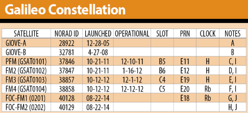
    Soyuz Fregat has a losing record so far with Galileo, being responsible for the August 2014 loosening of the first two full-operational capability (FOC) satellites into the dangerous Van Allen Belt. The first of these satellites has been successfully repositioned by the European Space Agency (ESA) into a mostly-but-not-totally useable orbit, and the second is currently en route to a similar spot.

    We do not wish to say we told you so, but we will. Back on March 26, 2014, we wrote on these virtual pages, “ESA’s year-end plan calls for two more dual-satellite launches in October and December on Russian Soyuz rockets — new partners to the Galileo dance, bringing perhaps new technical connectivity issues.”

    “Rockets are tricky,” said Tesla/SpaceX CEO Elon Musk, after his Falcon 9 Reusable rocket exploded over Texas at roughly the same time that Soyuz Fregat mis-delivered two Galileo satellites into wrong orbits.

    Musk meant tricky in actual operation, but we may also add, tricky in scheduling, in getting a cargo aboard a spacebound vehicle. Arianespace’s calendar is particularly filled with telecomm satellites impatient to be put aloft, with Ariane 5 being the preferred launcher of many. Soyuz availability, understandably, is somewhat more open.

    Four

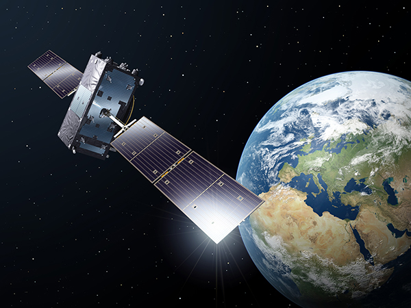
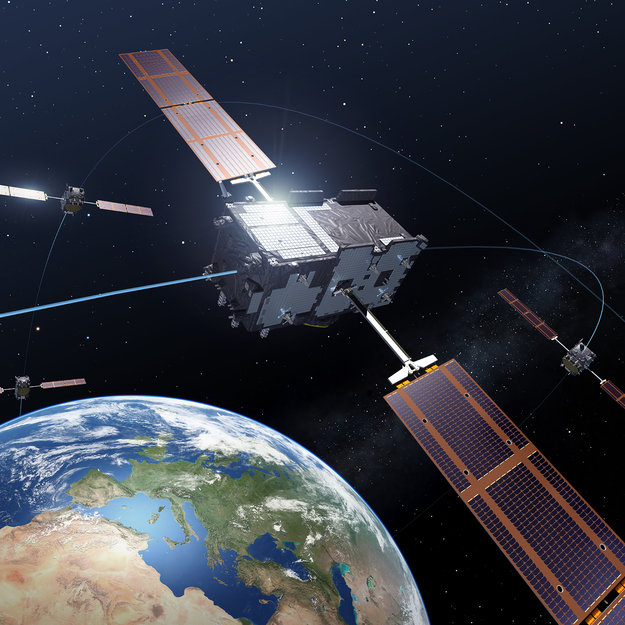
    Four for the total of four Galileo satellites now orbiting and broadcasting useable signals at all times for all users. These four come from the in-orbit validation (IOV) generation.

    Galileo-chart-Jan2015

    The two added FOC satellites, no longer in a bad orbit, now in a sort-of-pretty-good orbit, should be useable at some times, for some purposes, by some people. Peter Steigenberger and André Hauschild, researchers at the German Aerospace Center (DLR) / German Space Operations Center, wrote in this magazine in January that:

    “Despite the orbit injection error, the new Galileo FOC satellite has now been successfully activated and added to the Galileo constellation. Unfortunately, the current orbit is incompatible with the standard Galileo almanac format, which may cause restrictions for some commercial receiver types.

    “Nevertheless, the satellite can already be tracked by a wide range of geodetic receivers with existing firmware versions and it will, in fact, be possible to use the new satellite for diverse applications in surveying, precise positioning, and geodesy, as well as in general multi-GNSS studies. We now look forward to the activation of the second FOC satellite, which can be expected in early 2015 and will, for the first time, offer multi-frequency signals from a total of five Galileo satellites.”

    If you have four fully useable satellites and two partially useable satellites, what do you have? Does six = five functionally in this case? Or perhaps 5.5?

    Six

    Six for the oncoming new Galileo FOC satellites to be launched in 2015, according to some schedules and some official announcements.

    On a year-opening preview of operations given on Jan. 19, Thomas Reiter, Head of the European Space Operations Centre (ESOC) in Darmstadt, Germany, outlined the launch schedule for Galileo in 2015. Six new FOC satellites in total:

    • Galileo L4 with two on March 26
    • Galileo L5 with two in September
    • Galileo L6 with two in December.


    Now, six satellites divided by three launch dates gives two satellites per launch. Seeming to indicate a Soyuz rocket for all three dates. Reiter did not mention any rocket by name, but this would be the inference.

    That’s putting a brave face on the situation. Back in May, Russia suffered its fifth rocket launch crash in the past four years, raising serious concerns about the reliability of Russian rockets and launch procedures. Subsequently, the August Galileo launch that went so wrong was controlled by Arianespace, but it did use the Russian equipment.

    It strains credulity that an omission or oversight in the system thermal analysis  during stage design of a million-dollar rocket, designed to carry million-plus-dollar satellites in a 21st-century endeavor, could permit the creation of a thermal bridge between two feed lines, causing one of them to freeze during a crucial phase of space operations — but that is what apparently happened at some point at NPO Lavochkin in Russia, and that is what ultimately caused Galileo such misfortune. All parties concerned swear that this problem has been corrected in every other Soyuz Fregat, but who knows what other anomalies lie undiscovered therein?

    So putting all your 2015 money aboard Soyuzes is really rolling the marbles. Even if, as Elżbieta Bienkowska, Member of the EC in charge of Internal Market, Industry, Entrepreneurship and SMEs stated at this week’s 7th European Space Conference: EU Space Policy Confronted With the Rising Demand for Services and Applications, “We agreed to contract insurance for the next launches.”

    Eight

    Eight for the oncoming new Galileo FOC satellites to be launched in 2015, according to other schedules and other official announcements.

    “2015 will be a crucial year for the European space industry. We have big plans,” said Maros Sefcoviv, vice-president of the EC in charge of Energy Union, earlier at the very same 7th European Space conference, EU Space Policy Confronted With the Rising Demand for Services and Applications.

    “On the biggest one, we are planning five launches, which will bring up to space 10 satellites: eight for our Galileo constellation, and two for Copernicus. This is something that will put these programs over, I would say, over the edge, in a way, to be able to offer early services from Galileo, and to develop the program of Copernicus. It would prove the resilience and competitiveness of the European space industry, and its ability to serve the businesses, and what I think is most important, to offer new kinds of services to the citizens.”

    “For our flagship programs like Galileo and EGNOS, our priority must be to deliver services as soon as possible. That is why the satellites have to be delivered and operations must be ready as soon as possible.”

    Now, if you have eight satellites to go up in three launches, that would mean one of them has to go with four aboard. Thus, an Ariane 5 Galileo launch this year after all? Or possibly four Soyuz launches, although one more launch date could just just as hard to come by as a launch vehicle.

    Hard to tell. Very hard to tell. Extremely hard to tell, from the outside.

    Those who do not study history are condemned to repeat it, goes the dictum. Those who do study GNSS history, in this case, are likely only to repeat past pronouncements without any perceptible advance in clarity.

    Way, way back in March 2013, an EC program manager told GPS World, “Then, in 2014 [after four FOC satellites were to rise in 2013, which did not happen] we will see three Soyuz launches of two satellites each. We do not have the precise launch dates yet, but they are likely to be in April, June, and September. In December 2014, we expect to have the first launch using the Ariane 5 launcher, which is capable of deploying four satellites in one go. This means that by the end of 2014 Galileo will have deployed 18 satellites in orbit.”

    Now, the target has moved several times since then, and the schedule has slid accordingly.

    “In 2015, there will be two Ariane 5 launches, one in the middle of the year, one at the end, each carrying four satellites.”

    Six or Eight?

    Either number this year, we would surely appreciate. To return to Ms. Bienkowska, she left a little fudge room in her presentation: “We aim to launch at least six satellites this year.”

    Well, at least we are all moving forward. Resolutely.

    ——————————–

    I am indebted to Tim Reynolds, GPS World’s Brussels-based European correspondent, and to Peter de Selding, Paris bureau chief of SpaceNews, for their assistance in gathering diverse intelligence on this topic. Tim Reynolds will have an up-to-date view of this and other Galileo developments when we publish the next issue of the EAGER* newsletter at the end of March. Subscribe for free.

    * The European GNSS and Earth Observation Report

  • Six Galileo Satellites Planned for 2015 Launch

    Six Galileo satellites are scheduled to be launched this year, European Space Agency (ESA) Director General Jean-Jacques Dordain said on January 16.

    “The launch of six satellites is scheduled for 2015. The [European] Commission will determine the terms of the launches at the end of January,” Dordain said at a press briefing. The satellites will be put into orbit by Ariane 5 and Soyuz carrier rockets.

    The Galileo project is jointly implemented by the European Union and the ESA.


  • Galileo Service Interruption Planned for System Upgrade

    Galileo Service Interruption Planned for System Upgrade

    Operators of Galileo's Ground Mission Segment at the Galileo Control Centre in Fucino, Italy. These operators oversee the navigation services of the Galileo constellation.
    Operators of Galileo’s Ground Mission Segment at the Galileo Control Centre in Fucino, Italy. These operators oversee the navigation services of the Galileo constellation. Photo: Galileo

    Galileo’s navigation messages will shortly stop being updated to enable the migration of a new release for Galileo’s ground mission segment, announced the European Space Agency.

    Although the actual navigation signals will continue to be transmitted, the generation and uplink of the navigation message — which renews the contents of the signal — will be interrupted during the last week of January for about five weeks.

    The accuracy of the navigation message received by users will slowly degrade, or in case of a reset in the satellite signal generator the message content will be dummy material. The users will be informed accordingly through a warning flag in the disseminated message, or through the online Notice Advisory to Galileo Users.

    “The main benefits of this migration from V1.2 to V2.0 of the Galileo Ground Mission Segment are better overall performance and availability, increased robustness and improved operability,” explained ESA’s Martin Hollreiser, who is overseeing the mission segment’s development with Thales Alenia Space France as prime contractor. “The latter is achieved through enhanced operator interfaces, increased access to performance data and the automation of procedures.

    “Various ‘non-conformances’ identified by operators over time have been fixed, while overall security has been further strengthened through treatment plans,” Hollreiser said. “This is in particular true for the Public Regulated Service, or PRS, the most secure Galileo class of signal. Finally, the number of Galileo Sensor Stations will increase from 12 to 15 worldwide and the number of Galileo Uplink Stations from four to five.

    “The new Sensor Stations will be on Santa Maria in the Azores, Ascension Island in the mid-Atlantic and Kiruna in the Swedish Arctic. The additional Uplink Station will be on Papeete, in French Polynesia. Such system improvements have always been part of our planning since the contract began in 2011.”

    Galileo’s worldwide ground mission segment is one of the most complex developments ever undertaken by ESA, with twin European Galileo Control Centres and a network of sensor and uplink stations deployed on remote sites across the world. They are all interconnected via a robust satcoms realtime network.

    While satellite control and housekeeping are performed by Galileo’s Ground Control Segment in Oberpfaffenhofen, Germany, the Ground Mission Segment that provides the navigation and timing services and related performances is operated from a separate centre in Fucino, Italy.

    Galileo’s ground segment encompasses twin European Galileo Control Centers and uplink stations on remote sites across the world. They are all interconnected via a robust satcom network. It includes Galileo Sensor Stations (GSSs) to provide coverage for clock synchronization and orbit measurements; uplink Stations (ULSs) to uplink navigation and integrity data to the Galileo satellite navigation payloads for rebroadcast to users; Telemetry, Tracking and Command Stations (TT&Cs) to manage the satellite platforms; an In-Orbit Test (IOT) site at Redu for satellite payload testing and a trio of Medium-Earth Orbit Local User Terminals (MEOLUTs) for search and rescue activities.
    Galileo’s ground segment encompasses twin European Galileo Control Centers and uplink stations on remote sites across the world. They are all interconnected via a robust satcom network. It includes Galileo Sensor Stations (GSSs) to provide coverage for clock synchronization and orbit measurements; uplink Stations (ULSs) to uplink navigation and integrity data to the Galileo satellite navigation payloads for rebroadcast to users; Telemetry, Tracking and Command Stations (TT&Cs) to manage the satellite platforms; an In-Orbit Test (IOT) site at Redu for satellite payload testing and a trio of Medium-Earth Orbit Local User Terminals (MEOLUTs) for search and rescue activities.

    A user’s satnav receiver needs signals from at least four satellites. It actually measures the time the signal takes to reach its antenna from the satellites, then converts time into distance to compute its spatial position as the intersection of the four resulting spheres. To reach sufficient level of precision, the time synchronization of the overall system clocks must stay accurate to a few billionths of a second, and any drift in satellite orbits must be corrected for.

    This is the task of the Ground Mission Segment in the control center, which continuously receives signal measurements from the sensor stations around the world. Based on these measurements, it computes exact satellite orbits and time synchronization for the satellites’ onboard atomic clocks.

    These corrections are incorporated into the ephemerides included in an updated navigation message, which is uplinked to the satellites for dissemination to the user. The updated ephemerides information in the navigation signal provides to the user receivers the information required to compute their exact position.

    The new Papette Uplink Station in Tahiti, French Polynesia, used for uplinking navigation messages for rebroadcast to users from Galileo satellites.
    The new Papette Uplink Station in Tahiti, French Polynesia, used for uplinking navigation messages for rebroadcast to users from Galileo satellites. Photo: Galileo
  • ESA International Summer School Set for July

    The ESA Summer School is scheduled for July 21-31, at the Campus of the Technical University of Ostrava, Czech Republic. The school provides attendees with a comprehensive overview of satellite navigation, starting from the various GNSS, the signals, the processing of the observations in a receiver, and finally determining the position-navigation-time (PNT) solution.

    Lab work will be carried out to give attendees hands-on experience. In addition, lectures on Intellectual Property Rights (IPR) and Patents, as well as on business aspects will be provided. The future of satellite systems will also be discussed. The main emphasis will be on the development of a group project using innovative ideas and covering all aspects, from the idea, business plan, and technical realization to the marketing of the product or service.

    The program is open to graduate students (with a first university degree), Ph.D. candidates, early-stage researchers and young professional willing to broaden their knowledge. International renowned scientists and specialists will give the lectures as well as the practical exercises and lab work.

    The following participants can register for the ESA Summer School:

    • Graduate students (more than 3 years studies)
    • Ph.D. students and postdoctoral researchers (< 35 years)
    • Young engineers and professionals from industry and agencies (< 35 years)

    The number of participants is limited to 50. Early registration (reduced rate) is recommended (first come, first serve).

    For more information on the detailed program, and to register, visit the event website.

  • Get a Galileo Position Fix? ESA Wants to Give You a Prize

    Get a Galileo Position Fix? ESA Wants to Give You a Prize

    First_Galileo_position_fix-W
    Javier Benedicto, ESA’s Galileo Project Manager, looks on as Europe’s own satellite navigation system performs its historic first position fix of longitude, latitude and altitude. The position fix took place at the Navigation Laboratory at ESA’s technical heart ESTEC, in Noordwijk, the Netherlands on the morning of March 12, 2013, with an accuracy between 10 and 15 meters — expected taking into account the limited infrastructure deployed so far. Horizontal accuracy reached as high as 6 m. The left-side screen shows the position fix while the right side screen shows the position of the four Galileo satellites and their current signal coverage.

    Did you get a fix on four Galileo satellites? Then there could be a certificate in it for you! ESA will recognize Galileo pioneers with commemorative certificates to the first 50 entities who document their achievement of a past or present fix. Details of how to apply are provided here.

    To mark the first anniversary of Galileo’s historic first satnav positioning measurement, ESA plans to award certificates to groups who picked up signals from the four satellites in orbit to perform their own fixes.

    In 2011 and 2012 the first four satellites were launched — the minimum number needed for navigation fixes.

    Europe’s Galileo satnav system.
    Europe’s Galileo satnav system.

    On March 12, 2013, Galileo’s space and ground elements came together for the first time to perform the historic first determination of a ground location — the Navigation Laboratory of ESA’s Technical Centre in Noordwijk, the Netherlands.

    From this point, generation of navigation messages enabled full testing of the entire Galileo system — not just by ESA and its industry and institutional partners but also by any entity with a customized satnav receiver.

    ESA’s Galileo team has heard about position fixes carried out by organizations and companies all over Europe and beyond, including as far away as Vietnam.

    A year after the first fix, ESA is recognizing these Galileo pioneers with commemorative certificates to the first 50 entities who document their achievement of a past or present fix.

    Applicants should send in their name, address, details of the receiver they used, the start and end time of their fixes in Universal Time Coordinated (UTC) and a plot of their latitude/longitude position fixes overlaid on a map, such as Google Earth. Submissions should be sent to [email protected] within the next two months. Certificates will be sent out after May 12, along with an online results update. See details of how to apply here.

    The first Galileo services are scheduled to begin later this year, as more satellites are delivered into orbit. The next launches will occur in the second half of this year, each with two satellites aboard a Soyuz ST-B. They will take place in close succession to build up the constellation.

    Many satnav receiver chips are already technically Galileo ready, requiring only software upgrades from their manufacturer to begin working with Galileo signals along with GPS and other international satnav systems.

    Dual-frequency Galileo positioning performance during the In-Orbit Validation phase: positioning accuracy is an average 8 m horizontal and 9 m vertical (95% of the time). Its average timing accuracy is 10 nanoseconds on average. Plot courtesy of ESA.
    Dual-frequency Galileo positioning performance during the In-Orbit Validation phase: positioning accuracy is an average 8 m horizontal and 9 m vertical (95% of the time). Its average timing accuracy is 10 nanoseconds on average. Plot courtesy of ESA.