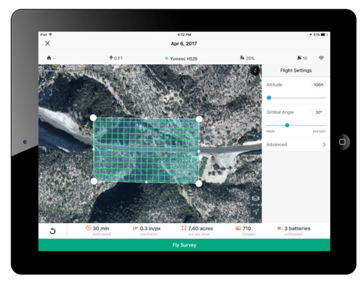
3DR, makers of Site Scan, has partnered with Esri to develop Site Scan Esri Edition, a custom version of its iOS app for drone flight planning and data capture that works seamlessly with Esri’s ArcGIS Online and Drone2Map for ArcGIS.
The Site Scan Esri Edition app will complement Esri’s Drone2Map for ArcGIS software by providing full drone project mission planning and a simple workflow for transferring drone captured data into the Esri ArcGIS ecosystem.
Screenshot: 3DR and Esri
Users will be able to connect to ArcGIS Online with an Esri sign-in. The app will allow users to directly use Esri data layers from ArcGIS Online — including custom data layers from the user’s FedRAMP authorized ArcGIS Online organization account — as base and reference data for their drone flight planning mission.
Esri customers can use any drone currently supported by Site Scan, including a variety of DJI drones. Site Scan also supports a custom version of the new Yuneec H520 commercial drone by 3D, which is based on the Dronecode PX4 software and designed to be an open and secure drone option for use on U.S. government projects.
“I’m thrilled that we’ve been able to work with Esri to provide its users with flight planning and drone capture tools,” said Chris Anderson, CEO of 3DR.
“3DR has been a leader in the drone industry, and we are excited to support this development effort,” said Cody Benkelman, imagery product manager at Esri. “A drone flight planning app that connects directly to ArcGIS Online will provide great value to Esri’s worldwide customer base, and simplify the process of ensuring successful projects using Drone2Map.”
Site Scan Esri Edition app will be available on the Esri Marketplace in late September for free to ArcGIS customers.
Esri is updating the ArcGIS Living Atlas of the World, a vast collection of geographic information from around the globe. The updates include new data and capabilities for users to gain insight for helping in decision making, as well as a more complete and dynamic picture of the world.
The new features were introduced at this year’s Esri User Conference, held July 9–13 in San Diego, California.
The new Earth Systems Monitor app, powered by Living Atlas data, showing Sea Surface Temperature. (Image: Esri)
Earth Systems Monitor. This new app (currently in beta) is powered by Living Atlas data. It allows users to see — on a 2D map or a 3D globe — historical, forecasting and real-time data for depicting land, the oceans and even the human footprint.
Users can see where events or phenomena such as marine temperature shifts are occurring at any time on the planet, or even model global population growth and its effects, the company said.
The configurable app will be released later this year. The app can be used with Living Atlas data layers or with other layers from an organization’s own data or ArcGIS Online.
Wayback Imagery. This digital archive of the World Imagery basemap enables users to access more than 80 different versions of world imagery captured over the past five years.
Each record in the archive represents a version of world imagery as it existed on the date it was published. Users can move back and forth in time and choose the imagery they want to use.
OpenStreetMap Vector Basemap. Moving to a local scale, OpenStreetMap (OSM) is an open, collaborative project to create a free editable map of the world, built by a community of mappers who contribute and maintain data about roads, trails, buildings, restaurants and more.
Until now, OSM was only available as a raster basemap in ArcGIS Online. The new vector basemap, introduced in beta, will be available for free to all ArcGIS users and developers.
“The Living Atlas shows how our community of users continues to contribute to the innovations that power our technology,” said Jack Dangermond, Esri founder and president. “The beauty of these new features is that they transform the data that users are supplying into valuable online services like Earth Systems Monitor.”
Living Atlas can be used to create indexes displaying properties such as vegetation health or soil moisture and quantifying the changes over time, enabling better understanding of the environment.
Earth Systems Monitor, OSM Vector Basemap and Wayback Imagery are all examples of how online GIS technology is transforming traditional mapping organizations into web service providers, Esri said. These innovations are just the latest steps in creating a living digital twin of the systems and processes that help run organizations, cities and even nations.
By fostering the adoption of apps, web maps, and collaborative efforts, Living Atlas is supporting end users who face increasing geospatial data demands, enabling them to be self-sufficient with the application of location intelligence across their organizations.
Wayback Imagery is currently accessible, while both OSM Vector Basemap and Earth Systems Monitor will be available soon in ArcGIS Online.
A roundup of recent products in the GNSS and inertial positioning industry from the August 2018 issue of GPS World magazine.
OEM
IP Solution
With multi-constellation GNSS for internet of things (IOT) devices
The Dragonfly NB2 is a highly integrated and modular IP (internet protocol) solution optimized for Cat-NB2 (3GPP Release 14 eNB-IoT) that can seamlessly be incorporated into chips and modules by the multitude of companies looking to address the large and fast-growing cellular IoT space. GNSS hardware package. For customers developing NB-IoT products that also require GNSS capabilities, Ceva-Dragonfly NB2 includes a new power-optimized GNSS hardware package, with GNSS RF receiver and multi-constellation digital front-end. The GNSS package speeds up both acquisition and tracking tasks by up to 8 times compared to Ceva-Dragonfly NB1, enabling a host of popular NB-IoT use cases, including people, livestock and asset tracking and geofencing.
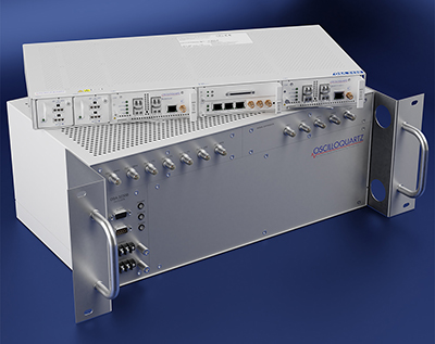
Provides timing accuracy and stability when GNSS signal is lost
Photo: Oscilloquartz
Oscilloquartz has launched its enhanced primary reference time clock (ePRTC) system to enable a high level of timing accuracy and stability, even when the GNSS signal is lost. The system provides a timing source for mission-critical transport systems, such as utility networks, government infrastructure and radio access networks, and provides the strict synchronization needed for LTE-A and 5G applications. Featuring the OSA 3230B ePRC atomic cesium clock connected to an Oscilloquartz clock combiner and grandmaster, the new solution offers the extremely stable frequency of a cesium clock with the UTC-traceable signal provided by GNSS. When combined with the OSA 5430, the OSA ePRTC system provides full hardware redundancy and multiple fan-out options including PTP over 10 Gbit/s.
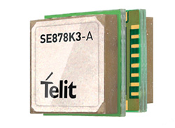
The SE878Kx-A series of GPS and GNSS integrated antenna receiver modules offer high performance, maximum reliability and low power consumption for consumer and business applications. The SE878K3-A and SE878K7-A are compatible with GPS, GLONASS, Beidou and Galileo and also enable device vendors to develop quickly and cost-effectively location-based IoT solutions for use in virtually any country worldwide. The SE878Kx-A series supports dual internal-external antennas to ensure connectivity when one is broken or compromised, along with a SAW filter to maximize jamming immunity. The modules are designed for mission-critical applications and other use cases where reliability is key, such as alarms, stolen cars or high-end asset tracking. The series also provides seamless integration with Telit’s cellular modules, including eCall/ERA-GLONASS compliant solutions.
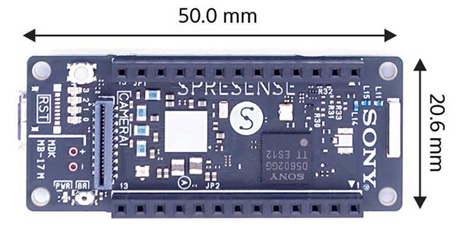
The Spresence main and extension boards are designed for internet of things (IoT) applications. The main board uses a multi-CPU structure equipped with Sony’s GNSS receiver (GPS+GLONASS) and high-resolution audio codec. A variety of systems for applications such as drones and other IoT devices can be built by combining the boards and developing the relevant applications. The boards’ software and hardware is available via open platform, allowing for a wide range of developmental possibilities. The main board can be used to control a drone using GPS positioning and a high-performance processor, voice-controlled smart speakers and low-power consumption sensing cameras. It also can be combined with sensors for use in systems that detect errors in production lines on the factory floor.
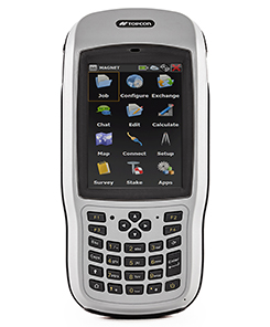
Designed for geopositioning, construction and mapping
Photo: Topcon
The T-18 handheld controller has a 3.7-inch sunlight-readable display, a 1-GHz processor and 1 GB of internal storage. For field data collection using Topcon’s MAGNET software, the T-18 offers a durable ergonomic solution with fast processing, excellent connectivity and a long (10-hour) battery life. It has a 3.5G cellular modem for connectivity with Topcon MAGNET solutions for sending and receiving data to the cloud company account. The modem also can be used for real-time kinematic (RTK) correction services. Other features include Bluetooth and an IP65 rating for dust and water protection in demanding job-site conditions.
The SXblue ToolBox is an Android application for SXblue GNSS receivers, enabling users to view and analyze the position data and metadata related to its location. The user can send commands that enable or disable some features, including systems in use, mask angle or differential angle, and constellation in use, including GPS, GLONASS, Galileo, BeiDou and SBAS. The SXblue ToolBox is also an NTRIP client capable of connecting to a NTRIP server for real-time kinematic (RTK) corrections, allowing the receiver to issue very accurate location information. The application can record, save and transfer raw data from the GNSS receiver, allowing post-processing on computers for surveying and geomatics professionals.The toolbox has been developed with special consideration for modern mobile devices and attention to user and dealer feedback. It includes a series of configurable audible and visual alarms for determining the thresholds of the information provided by the SXblue GNSS receiver.
The Leica RTC360 laser scanner is equipped with edge computing technology to enable fast and accurate creation of 3D models in the field. It combines high-performance laser scanning, edge computing and mobile app technologies to preregister captured scans quickly and accurately. With the push of a button, two million points per second of high dynamic range imagery can be captured to create a full-dome scan in under two minutes. It features a visual inertial system that automatically tracks movements between setup positions. The scans captured can be combined and preregistered on a mobile device, where they can be viewed and augmented with information tags.
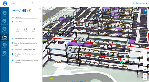
Location technology allows users to see rooms, gates and offices
Screenshot: Esri
ArcGIS Indoors is designed to enable interactive indoor mapping of corporate facilities, retail and commercial locations, airports, hospitals, event venues, universities and more. The solution applies the latest location technology to allow users to see and share where assets, rooms, departure gates and offices are located. It uses data streams, real-time processing and location intelligence tools to help businesses and other organizations understand how to better coordinate space and other resources with their facilities and campuses. Insights from sensor networks deliver real-time information to managers and executives through interactive dashboards, while visitors and employees can find useful information about the buildings they occupy. The solution also allows users to quickly access and explore critical business information, such as the location and status of fire extinguishers and their last inspection dates.
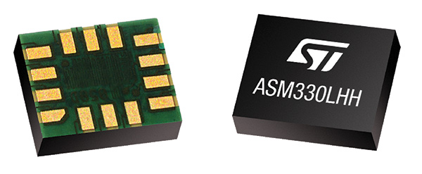
Meets demands for continuous, accurate vehicle location
The ASM330LHH module. (Photo: STMicroelectronics)
The automotive-grade ASM330LHH six-axis inertial sensor is designed for super-high-resolution motion tracking in advanced vehicle navigation and telematics applications. It lets advanced dead-reckoning algorithms calculate precise position from sensor data if satellite signals are blocked, such as in urban canyons, tunnels, covered roadways, parking garages or dense forests. Its advanced, low-noise, temperature-stable design enables dependable telematics services such as e-tolling, tele-diagnostics and e-Call assistance. Precision inertial data in six axes also meets the needs of advanced automated-driving systems. Automotive component manufacturer Magneti Marelli has selected the ASM330LHH for advanced telematics systems, to be fitted as original equipment by global automotive groups in upcoming vehicle ranges.
Esri and Waze smart cities partnership grows. (Image: Esri)
The free crowdsourced traffic and navigation app Waze is now fully supported by ArcGIS Online, where its live feed of mapped traffic alerts and other information, such as accidents, congestion and street damage, can be used in applications in minutes. Waze Live Alerts, available in ArcGIS Marketplace, is free to members of the Waze Connected Citizens Program. The program, a two-way sharing of publicly available traffic and road condition information, offers governments a stream of data, constantly updated in real time. This enables personnel to make data-driven infrastructure decisions and improves the efficiency of incident response.
Traffic engineers can use the data to analyze problems on the road and create targeted solutions.
Open-source platform for autonomous delivery and other iot
The AGL platform provides Mercedes-Benz Vans with the ability to create autonomous delivery robots. (Image: Daimler)
Automotive Grade Linux (AGL) is a collaborative cross-industry effort to develop an open platform for the connected car. Mercedes-Benz vans are using AGL as a foundation for a new onboard operating system for its commercial vehicles. The Mercedes-Benz “adVANce” initiative focuses on connectivity and internet of things (IoT) applications, innovative hardware solutions, new on-demand mobility and rental concepts, and fleet management solutions. The AGL platform provides Mercedes-Benz Vans with the flexibility to rapidly create tailored solutions for customers, including adding and connecting any kind of IoT component to the vehicle, such as sensors, automation controls and actuators. The new AGL-based operating system will debut on various Mercedes-Benz Vans prototype projects later this year.
eCyber is an integrated hardware-software product that protects vehicles against ransomware and other cyber-attacks. It can be installed in a vehicle by authorized parties, such as vehicle importers and fleet managers, in the aftermarket stage after the vehicle has left the factory, as well as by the OEM itself during manufacture. eCyber, a combined hardware and software solution in a compact box, is installed between the vehicle’s external communications device and the vehicle’s CAN (Controller Area Network) bus. It provides a secure gateway for outside communications to the CAN bus, allowing only communications with predefined parameters and values to go through. It blocks any unrecognized communications to and from the CAN bus, so no malicious digital communications can disrupt vehicle function.
Engineered for UAV-imaging missions, the iXM 100MP is a high-productivity metric camera with a range of high-resolution lenses. It is ready for integration with various UAV platforms, including Phase One’s DJI Matrice 600 Pro. The camera incorporates a medium-format sensor with backside-illumination technology, enabling high light sensitivity and extended dynamic range. Phase One also offers four new RSM lenses — with focal lengths ranging from 35mm to 150mm — to fit the new sensor’s 3.76 μm pixel size and 33 x 44 mm frame size. The lenses are available with either fixed-focus or motorized-focus functionality. The fixed-focus 35mm and 80mm lenses are especially suitable for surveying applications.
For quick approval of flights over controlled airspace
Screenshot: Skyward
Commercial drone operators in California and Hawaii — as well as a few areas in Nevada, Utah and Arizona — can get quickly authorized to fly in controlled airspace using the LAANC (Low Altitude Airspace Notification Capability) platform. Skyward is an FAA-approved airspace vendor. With Skyward, pilots with a Part 107 license can get permission to fly in regulated airspace in seconds compared to manual authorizations that can take months. This makes it significantly easier for businesses of all sizes, particularly in the construction and warehousing industries, to manage a fleet of drones to access valuable, cost-saving data. Skyward’s LAANC expansion includes airspace in the busy metro areas of Los Angeles, the Bay Area, San Diego, Las Vegas and more than 50 smaller air markets.
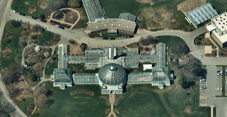
A capture of the Buffalo and Erie County Botanical Gardens in Buffalo, New York, taken in May 2018. (Image: Nearmap)
Fresh off an eye-grabbing appearance showcasing its new 3D products at last week’s Esri User Conference, Nearmap will deliver a free “Cooking with GIS” webinar Thursday, July 26.
The hour-long session will highlight ways that the company’s vertical, oblique and 3D aerial imagery can bring competitive advantage to surveyors, construction managers, telecomm engineers, city planners, realtors and investors, building contractors, property and natural resource managers, and many others. Using their geographic information systems (GIS) skills, these professionals can perform deep analysis and make decisions with confidence using detailed and up-to-date visual insights.
Nearmap won 2017 Esri’s Best New Content Partner Award in 2017, and the free webinar, subtitled “Esri + Nearmap,” focuses on the key advantages of seamlessly integration the company’s high-resolution aerial imagery into Esri mapping and software products.
Esri is an international supplier of geospatial information systems with more than one million users in 200 countries around the world. Nearmap’s ArcGIS Image Service Online provides users an easy and efficient way to incorporate high-resolution PhotoMaps within Esri ArcGIS Online. ArcGIS users can instantly access current 2.8” imagery within days of capture while also showing change over time using Nearmap’s historical archive.
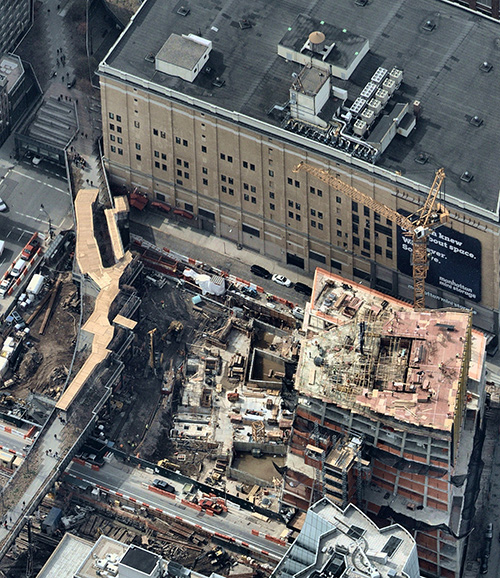
A New York City building site with temporary covered pedestrian walkway. (Photo: Nearmap)
As an integral partner in the ArcGIS ecosystem, Nearmap helped integrate their imagery with a wide range of Esri software solutions—both off the shelf and bespoke. Coupled with Portal for ArcGIS, the Nearmap ImageServer can be used in any application that is able to talk to ArcGIS Server, delivering power to the platform.
3D. Nearmap recently brought dramatic change to the aerial imagery market, announcing a national survey program providing high-resolution oblique imagery and derivative 3D products from its patented HyperCamera2 technology. The new camera system provides a high degree of overlap from different angles, so Nearmap can reconstruct the real world in detail, producing not only high-resolution orthomosaic and oblique imagery, but also surface and terrain models, natural color point clouds and textured 3-D meshes.
Users can immerse themselves in 3D textured mesh models, improving analysis and design activities. They can see different elevations and line of sight using the 3-D information. These features become important in many use cases, including airport or utility planning, or to determine the best location for a crane before a construction project.
Other applications include wireless telecommunications network modeling, solar panel design, tactical resource deployment, real estate development promotion, property valuation, insurance underwriting and smart cities.
Delivery. Nearmap is delivered through a user-friendly interface called MapBrowser or accessed via Esri, Autodesk and other third-party solutions.
Nearmap captures urban U.S. imagery multiple times per year, processes massive amounts of visual data, and uploads up-to-date aerial maps to the cloud within days. Patented imaging and processing technology delivery at speed of high-resolution aerial imagery as a service: orthographic (vertical) maps, multi-perspective panoramas and oblique aerial views.
The fully cloud-based PhotoMaps are accessible instantly via desktop and mobile, with 70% of the U.S. covered in major metros.
Clarity, color and 2.8″ GSD detail help users identify and accurately measure ground features with ease, detect change over time or monitor progress through the company’s library of precisely georeferenced historical imagery.
Nearmap imagery is refreshed up to three times per year principal coverage areas, with three orthomosaic captures incorporating one oblique capture. Nearmap’s orthomosaic imagery already covers nearly 70 percent of the U.S. population dating back to 2014.
Speakers on the July 26 webinar include Kevin Kwok, Nearmap technical product manager; Chuck Dostal, Nearmap geospatial technical engineer; and customer Mike Otillio, director of research for Colliers International, servicing the commercial real estate industry.
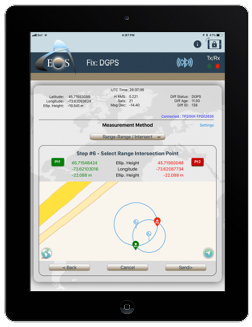
From left: Esri Program Manager Doug Morgenthaler, Laser Technology Sr. Product Manger Derrick Reish and Eos CTO Jean-Yves Lauture. (Photo: Eos Positioning)
The three-way partnership will enable field crews to collect centimeter-accurate 3D data in GNSS-impaired environments.
When combined with Laser Technology Inc.’s (LTI’s) laser rangefinders, the solution will allow field crews to capture centimeter-accurate 3D locations of hard-to-reach assets and in GNSS-impaired environments.
“By combining the high-accuracy of the Eos Arrow Series GNSS receivers and the laser capabilities of LTI, we can empower field crews to capture highly accurate XYZ coordinates from a safe distance,” LTI Senior Product Manager Derrick Reish said. “This eliminates the need for physically occupying every point. It also provides more accurate location data, with a more affordable mobile asset-management workflows.”
The Arrow Gold. (Photo: Eos Positioning)
The solution has been in the works for months, as demand has grown for hard-to-reach, high-accuracy mapping within the Collector workflow.
“Eos is extremely grateful to be a part of this initial release in high-accuracy asset location data with LTI’s laser rangefinders and Esri’s Collector mobile app,” Eos CTO Jean-Yves Lauture said. “Enabling this kind of accuracy means even the most budget-conscious field crews will be able to access the location of their hard-to-reach assets.”
All three teams have been working closely to ensure a seamless integration with Collector and ArcGIS Online. When using an LTI laser rangefinder and an Eos Arrow Series receiver with Collector, a field worker can easily shoot, capture and share high-accuracy 3D location data that is streamed into ArcGIS Online in real-time.
Image: Eos Positioning
The solution is expected to be particularly useful in urban corridors, highway settings, forested (or wetlands) areas, and other areas where assets are hard or dangerous to occupy. This will both increase accuracy and efficiency, as well as decrease safety liabilities in dangerous situations, the companies said.
“Esri is extremely pleased that Collector can now support the capture of high-accuracy asset locations from afar, leveraging our unique partnership with both Eos and LTI,” Esri Product Manager Jeff Shaner said. “This is a game changer for asset management.”
Prior to this release, field crews challenged with capturing high-accuracy 3D locations for hard-to-reach assets would need to use a total station with a different software workflow and then mesh the data back in the office, a clumsy and inefficient workflow requiring lots of additional training and expertise. With the new workflow, field crews can operate in GNSS-impaired environments at a high-accuracy level without leaving the Collector/AGOL environment, creating a highly efficient workflow.
The solution has been designed to provide several offset-mapping methods.
“The implementation of several measurement methods gives users the freedom of choice, so they can pick the right laser option which meets their accuracy needs,” Reish said.
Eos will unveil its offset measurement solution for Collector at the upcoming Esri User Conference in San Diego. For a field demonstration of how the solution works, attendees can visit Eos at booth #1019 during the conference, and attend the session “LaserGIS for Everyone: How to Combat Costly and Tedious Data Collection Workflows” at 10 a.m. on Wednesday.
According to Esri, ArcGIS Indoors applies the latest location technology to allow users to see and share where assets, rooms, departure gates and offices are located. Click to enlarge. Photo: Esri
Esri has debuted ArcGIS Indoors, which is designed to enable interactive indoor mapping of corporate facilities, retail and commercial locations, airports, hospitals, event venues, universities and more.
According to Esri, the solution applies the latest location technology to allow users to see and share where assets, rooms, departure gates and offices are located.
ArcGIS Indoors uses data streams, real-time processing and location intelligence tools to help businesses and other organizations understand how to better coordinate space and other resources with their facilities and campuses. Insights from sensor networks deliver real-time information to managers and executives through interactive dashboards, while visitors and employees can find useful information about the buildings they occupy, the company said.
The solutions also allows users to quickly access and explore critical business information, such as the location and status of fire extinguishers and their last inspection dates.
“ArcGIS Indoors brings the interior building space into the future by placing data about employees, schedules, meetings, customers and events into a geographic context,” said Nitin Bajaj, product manager at Esri. “Having spatial awareness gives executives, managers and employees better insight so they can operate more efficiently and competitively.”
According to Esri, ArcGIS Indoors will be available for widespread use by the end of 2018. In addition, a beta version of the product will be released at this year’s Esri User Conference, taking place July 9-13 at the San Diego Convention Center in San Diego, California.
A team of five volunteers armed with drones, advanced sensor systems and GIS technologies joined the response effort at Kilauea Volcano Lower East Rift Zone to assist in tracking and predicting the ongoing volcanic eruption.
Using small unmanned aerial systems (sUAS) together with air-quality sensors, advanced imaging tools and Esri’s spatial analytics and mapping, the team from the Center for Robot-Assisted Search and Rescue (CRASAR) provided real-time aerial views of the eruption.
The CRASAR team identified a new fissure not visible from the ground, projected the lava flow rate during the night when manned helicopters were not allowed to fly, and provided ongoing data collection from new thermal sensors technology.
The CRASAR response marks the first known use of sUAS for emergency response to a volcanic eruption and first known use of sUAS for sampling air quality. The CRASAR team provided Hilo Fire Department and the Civil Defense with live streaming of video from the sUAS over the new FirstNet cellular network.
“This latest CRASAR mission is another example of dedicated volunteers working together with private sector partners to deploy technology to save lives and property when disaster strikes,” said CRASAR Director and disaster robotics expert Robin Murphy. “With support from technology partners like Esri, Hangar Technologies, RemoteGeo and RMUS, we are able to both respond to active disasters but also demonstrate to the first responder community best practices and benefits of engaging robots and other technologies in disaster response.”
CRASAR supported tactical response operations at the Leilani, Hawaii, eruption event May 14-19, supplementing the University of Hawaii Hilo’s (UHH) sUAS capabilities and allowing UHH sUAS operators to focus on geographical and volcanology.
During the six-day Leilani deployment, the CRASAR team flew 44 sUAS flights, including 16 at night, using DJI 200, 210, Inspire, and Mavic Pro drones.
Esri’s Drone2Map for ArcGIS together with Hangar’s Enterprise Platform for 360-degree imaging enabled rapid 360-imaging for situational awareness.
Video and data were shared with local first responders using FirstNet, the first high-speed, nationwide wireless broadband network dedicated to public safety.
The CRASAR response team included sUAS pilots Justin Adams of Constellation Consulting Group, David Merrick and Laura Hart of Florida State University Center for Disaster Risk Policy, Jon McBride of Rocky Mountain Unmanned Systems, and Robin Murphy of Texas A&M University. Funding was provided in part through research grants from an insurance partner and the National Science Foundation.
“This eruption is especially impactful because of its location,” said Esri’s Public Safety Lead, Ryan Lanclos. “That makes the CRASAR’s use of drones and mapping technologies, and the near real-time situational awareness it provides of people, homes, businesses and infrastructure during this disaster, a resource first responders will be able to turn to time and again.”
CRASAR’s deployment to Hawaii marked a number of firsts for technology applied to disaster response. To interact with the same GIS mapping and imaging technologies responders used on the scene at Kilauea Volcano Lower East Rift Zone, visit this page.
Esri has published its latest book, “GIS for Surface Water: Using the National Hydrography Dataset,” by Jeff Simley, which details how to use geographic information system (GIS) technology to visualize and analyze data sets. Simley is an award-winning cartographer and the former lead of the Hydrography Program at the United States Geological Survey (USGS).
The book examines the complexities of surface water systems and shows readers how to use the Esri ArcGIS software, the USGS’s National Hydrography Dataset (NHD) and the Watershed Boundary Dataset (WBD), and the U.S. Environmental Protection Agency’s NHDPlus dataset to better study and manage the United States’ vast water system.
According to Esri, the book thoroughly examines the representation of water features and their attributes in a GIS and then turns its attention on how that data is structured in the NHD, WBD and NHDPlus datasets. In addition, after seeing how surface water hydrography can be modeled in a GIS, readers can then learn how to use these tools to solve real-world problems, such as protecting and restoring the fisheries habitat in Washington.
The book also offers instructions to guide readers to create surface water flow-volume maps that show how much water flows through any given river system.
“This book is unique in that it is the most comprehensive, authoritative source for the NHD,” said hydrologist David Maidment in the book’s foreword. “But it is more than that: It is a monument to the intellectual craft and dedicated effort of a generation of digital mapmakers who devoted their professional careers to the completion of this enormous task.”
Esri will be hosting its 38th annual Esri User Conference July 9-13 at the San Diego Convention Center in San Diego. The company expects more than 18,000 mapping and GIS users to attend the event, which will include 345 technical workshops and 243 presentations.
Futurist Juan Enriquez will present the keynote speech, “Evolving Ourselves — Redesigning the Future of Humanity.” According to Esri, his talk will explore the future of humanity as it depends on the intersection of geography and genetics as we design our places and ourselves.
Attendees will also hear presentations from users who are creating smarter organizations that can tackle complex global issues, including how to create more sustainable businesses, address homelessness, diminish poverty and counter the effects of climate change, Esri added.
Other presenters will include:
Civil rights leader and activist Dolores Huerta, who will discuss how the Dolores Huerta Foundation utilizes Esri technology to inspire and organize communities to build volunteer organizations empowered to pursue social justice;
New York Times best-selling authors James and Deborah Fallows, who will discuss their book “Our Towns: A 100,000-Mile Journey into the Heart of America,” which provides anecdotal stories about the challenges small-town America faces; and
Felix Finkbeiner, a recent college graduate and recipient of the German Federal Cross of Merit, will detail his Trillion Trees Campaign — a commitment to the environment that has grown from planting 1 million trees to planting more than 15 billion trees in 190 countries under the guidance of the United Nations Environment Programme.
“The Esri User Conference is truly as the name suggests — a conference for our users,” said Jack Dangermond, Esri founder and president. “This is an opportunity for all of us to come together and learn from each other so we can take part in personal development and organizational advancement to further the impact that we can have on our planet.”
Esri’s ArcGIS software is being integrated into SAP’s latest cloud-based offering, SAP HANA spatial services, to help customers create location-aware business applications faster, according to spatial analytics company Esri.
Based on SAP Cloud Platform, the new offering enables businesses to process location data such as complex imagery, as well as visualize and analyze their authoritative data in a geospatial context.
The new geo-enabled solution from SAP will allow users to deliver their data through consumer-friendly maps and integrate the results into custom business applications, the company said. Customers using SAP software will also be able to create custom models that efficiently process streams of Earth observation data such as water content or soil temperatures and see this data on high-quality basemaps provided by Esri’s ArcGIS Online.
Most business objectives — such as increasing revenue growth, reducing operational costs or improving customer service — rely on some sort of location data. Unfortunately, many executives lack an accurate and up-to-date understanding of where performance is going well and where improvements need to be made.
This new offering from SAP, which leverages Esri technology, lets organizations extract high-value business information from satellite, drone and open data sources and then easily discover and share location-based insights.
“As an SAP global technology partner, we are very excited about this offering, as it demonstrates that SAP and Esri products work better together,” said Chris Cappelli, director of strategic business development at Esri. “Users of SAP HANA spatial services can now achieve native integration of spatial and enterprise data across all business processes. By putting the power of location information into the hands of key stakeholders, businesses can make better-informed decisions with their own data.”
The integration follows SAP’s announcement on Jan. 24 that Esri supports SAP HANA as an enterprise geodatabase with the release of ArcGIS 10.6 and ArcGIS Pro 2.1.
Esri and SAP customers can benefit from enhanced performance and scalability as well as full integration of both enterprise and spatial data. Both Esri and SAP continue to deliver new innovations that help lower total cost of ownership and administration costs brought on by the tight integration of IT and geospatial landscapes, Esri said.
Esri will showcase its new integration of location intelligence technology with SAP HANA spatial services at SAPPHIRE NOW and ASUG Annual Conference in booth #1239.
The three-year program helps emerging business partners bring new and innovative products to Esri customers.
The initial partnership between Hangar and Esri will enable ArcGIS customers to request and receive autonomous, precision-captured drone data on demand from within ArcGIS, enabling industries to gain real-time awareness and insight about locations and features.
The GIS community has grown accustomed to ambiguous and infrequent imagery. While emerging robotic enablers like drones provide a high-resolution, low-cost alternative to satellite and manned aircraft imagery, there hasn’t been a feasible way for GIS professionals to repeatedly gather precision location insight at scale, from potentially thousands of features within Esri maps, Hangar said in a statement.
Hangar not only makes aerial data possible at this scale, but also available on request from within ArcGIS. Using a system of systems, Hangar streamlines and automates the 4D data supply chain, enabling task-and-receive reality capture. In the near future, ArcGIS users will be able to request aerial insights at any feature, and have imagery delivered back in 24 to 48 hours or less.
“The pain we see in the GIS community is an inability to quickly and efficiently pair 2D data with the 3D reality,” said Jeff DeCoux, CEO and founder of Hangar. “We’re excited to work with Esri to deliver on-demand, precision 4D insight to ArcGIS users. Hangar will enable businesses to take full advantage of robotics as instruments of data collection, and provide the industry much needed repeatability and scale.”
ArcGIS Online users will have the capability to request and receive aerial imagery at variable frequencies or volumes. Requests can be made manually, on an as-needed basis, or automatically, based on contextual triggers or volume requirements. Data is autonomously captured, automatically processed, then delivered back to the customer via a high-speed delivery engine.
The digital missions behind requests are saved indefinitely, and can be performed repetitively with absolute precision and accuracy, preserving data integrity over time. ArcGIS users will be able to view captures within 24 to 48 hours from the initial request, across a variety of data types.
“Hangar empowers Esri users to explore any of the thousands of features within ArcGIS maps, observing ground truth at each pin in incredible detail, today and over time,” said Francis Kelly, Esri, global partner programs manager. “Hangar adds valuable data validity and scalability to the budding drone industry. We’re excited to work with them to give Esri users the ability to analyze and consume physical world content in a new and meaningful way.”
As big-data levels of precision spatial data are collected over time, Hangar will work with Esri to intelligently apply change detection and pattern recognition to enable a new era GIS that includes artificial intelligence and machine learning.
Hangar will be attending the Esri User Conference, July 9-13 in San Diego, at booth Z19 to demonstrate its technology and showcase the partnership with Esri.
Location intelligence system introduced for nations in need of modernized land governance
Esri will join this year’s FIG Congress, hosted by the International Federation of Surveyors, taking place May 6–11 in Istanbul, Turkey.
At the annual event, Esri will showcase its new program for modernizing land administration systems tailored to the needs of developing countries and island nations.
Good land governance requires effective policies, efficient processes and institutions that can determine, record and disseminate information about the tenure, value and use of land. The new Land Administration Modernization Program allows land administration organizations in developing nations to meet these challenges and lay the foundation for economic success.
Esri’s program delivers an inexpensive, scalable platform that allows simple field capture, management and publication of parcel data in the cloud, or that can be implemented as an enterprise system meeting the needs of any modern land administration office.
The software is donated to eligible countries for four years from date of order, and includes maintenance updates and support from Esri.
At FIG Congress, Brent Jones, land records/cadastre industry manager at Esri, will host the workshop, “Modernize Land Administration Systems: Off-the-Shelf GIS Technology for Modern Cadastral Operations,” May 9, 11 a.m.–12:30 p.m., at Hamidiye Hall, Istanbul Congress Center.
The workshop will demonstrate how Esri’s ArcGIS platform is a complete, interoperable, open, and purpose-built system for cadastral operations to improve efficiency, manage data integrity, and share data across organizations and with the public. ArcGIS delivers necessary capabilities ranging from fit-for-purpose to enterprise cadastral systems, whether the aim is improve data quality, increase throughput, or enhance spatial accuracy.


 The initial partnership between Hangar and Esri will enable ArcGIS customers to request and receive autonomous, precision-captured drone data on demand from within ArcGIS, enabling industries to gain real-time awareness and insight about locations and features.