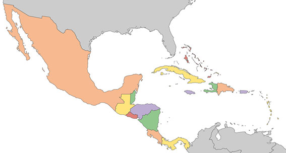
A new Galileo Information Center for Mexico, Central America and the Caribbean has opened in Mexico City, with training facilities in Querétaro, Mexico. The 177-million population is a largely untapped market for space, according to Telespazio Ibérica.
Telespazio Ibérica will run the center as leader of a consortium composed of European and local industrial and institutional partners such as everis, Enaire, Geotecnologías, and universities including the Universidad Politécnica de Madrid and the Universidad Nacional Autónoma de México.
The center is co-financed by the Directorate-General for Defence Industry and Space (DG DEFIS) of the European Commission for 36 months. Its goal is to enlarge the ecosystem of Galileo Information Centers as it joins two existing centers in Chile and Brazil, active since November 2019. The centers contribute to the European Commission’s outreach to promote the EU Space Programme and foster its market uptake in Latin America.
The new center will help improve visibility of European satellite navigation and promote cooperation on Galileo and EGNOS between the EU space ecosystem and regional stakeholders. This includes building valuable insights on local GNSS markets, monitoring local and regional satellite navigation initiatives, and seeking to understand regional needs and the market potential for European GNSS. The center will provide communication, promotion and training activities.
“Telespazio Ibérica already plays a key role in the Galileo Service Center in Madrid,” said Miguel Bermudo, CEO of Telespazio Ibérica. In Madrid, the company operates on behalf of Spaceopal, a joint venture between Telespazio and the German Space Agency DLR, under the GSA contract for the Galileo Service Operator.
“We have chosen to co-finance this project with DG DEFIS to promote Galileo in Mexico, Central America and the Caribbean,” Bermudo said, “considering its presence in this important region to be of a great strategic value both in promoting the use and applications offered by Galileo and the opportunity it represents for Telespazio Group.”
In a first for any satellite navigation system, Galileo has achieved a positioning fix based on open-service navigation signals carrying authenticated data. Intended as a way to combat malicious spoofing of satnav signals, this authentication testing began at ESA’s Navigation Laboratory — the same site where the very first Galileo positioning fix took place back in 2013.
These historic first authenticated signal position, velocity and timing fixes were made using a total of eight Galileo satellites for around two hours on Nov. 18. The tests represent a first proof of concept for an eventual operational service offering positioning with authenticated data to users.
Spoofing has, for instance, been demonstrated as a means of forcing down drones or redirecting ships, while some high security locations — as well as disrupted international borders — have become notorious for spoofing signals that prevent the reliable use of satnav in their vicinity.
The Galileo Control Centres send the navigation signal to the GSC for the addition of the authentication code, which is then returned for uplink to the satellites.
“When a receiver picks up a navigation signal from a satellite, up until now it has no way of confirming that was indeed its source,” said navigation engineer Stefano Binda, overseeing the project for ESA. “This can result in spoofing — malicious people and organisations using false signals to mislead users about their actual position. This authentication service offers a way to prevent such deception.”
“In recent years, this problem has become sufficiently pronounced as a weak point that the European Commission, ESA and European GNSS Agency (GSA) decided to develop signal authentication as a differentiator for Galileo,” Binda said.
An ESA Navigation Directorate team at the Agency’s ESTEC technical centre in the Netherlands worked with its GSA counterparts at the twin Galileo Control Centres (GCCs) in Italy and Germany and the Galileo Service Centre (GSC) in Spain. “In everyday authentication you might send a document that has been digitally signed, where both sender and recipient use compatible cryptographic keys to validate the document’s source of origin,” Binda said.
“In this case we were working with a constrained amount of bandwidth within the navigation signal, so instead opted for a ‘delayed key’ approach. This means the initial data come along together a short tag which, within a short stretch of time usually not exceeding 30 seconds, is followed by a key, which is able to validate the tag and authenticate the data associated with it.”
During the test campaign, the Galileo Control Centres send the navigation signal to the GSC for the addition of the authentication code, which is then returned for uplink to the satellites, to be received and authenticated by the test receivers at ESTEC’s Navigation Lab and elsewhere in Europe, in participating laboratories.
To enabled the authentication test campaign, Thales Alenia Space in France served as prime contractor to upgrade of the Galileo Mission Segment — the world-spanning system that determines and create the navigation messages broadcast by Galileo satellites. Thales Alenia Space in Italy was responsible for the system level integration.
No modification of onboard satellite systems has been required to support Open Service Navigation Message Authentication (OSNMA), as spare bandwidth was made use of.
“We used our standard laboratory Septentrio test user receivers with a software add-on,” Binda said. “The beauty of this approach is that receivers will be able to make use of the future authenticated service without needing any new hardware, only software updates — apart from additional measures that might be mandated for operation in practice.”
ESA and GSA are continuing their authentication testing, with a view to introducing an operational Open Service Navigation Message Authentication service for users in the near future.
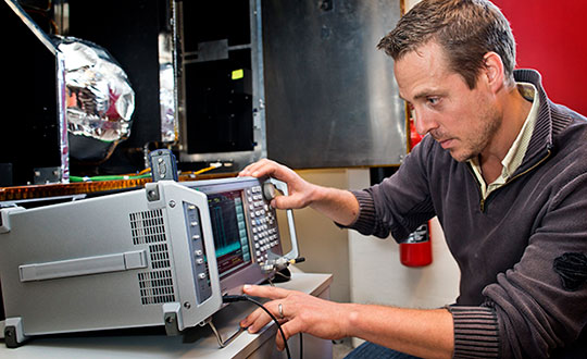
ESA’s Radio Frequency Systems, Payload and Technology Laboratories perform RF research for both the space and ground segments. (Photo: ESA)
The European Commission has issued industrial contracts worth €1.47 billion ($1.97 billion) to build next-generation Galileo satellites to Airbus and Thales Alenia Space, reports BBC News.
Both companies told BBC News that they will not speak publicly about their contracts wins until documents are signed, which could take several weeks.
Each contract is for manufacture of six satellites, to orbit no earlier than 2024. They will feature digitally configurable antennas, inter-satellite links, new atomic clocks and propulsion systems that use electric engines.
Airbus and TAS built the four Pathfinder in-orbit validation satellites that first demonstrated Galileo. A consortium of OHB-System and Surrey Satellite Technology Ltd. built the first operational Galileo satellites, but the consortium ended following Brexit.
“In some specific cases, e.g., for critical infrastructures and applications requiring both continuous availability and fail-safe operations, GNSS cannot be the sole means of positioning and timing information.” European Radionavigation Plan, 2018
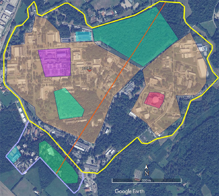
The Joint Research Center in Ispra, Italy, is the preferred demonstration site. (Photo: European Commission)
The European Commission is undertaking a GNSS backup technology demonstration, much like the one completed by the U.S. Department of Transportation earlier this year. Companies from many countries outside the European Union, including the United States, are eligible to participate. Responses are due by Jan. 13, 2021.
A tender issued on Oct. 26 says that the goal is for the commission to better understand available non-GNSS PNT technologies. Also, they are interested in services that can provide positioning and navigation, and/or time.
Completely Independent from GNSS
Since the intent is to provide a backup for GNSS during an outage, all offered technologies must be completely independent. Specifically, they must have “no common points of failure with GNSS.”
Some industry observers have opined that this eliminates any space-based capabilities from consideration. Coronal mass ejections from the sun have long been considered a threat to satellites. Others have wondered if networked-based solutions could be also excluded because of frequent use of GNSS for synchronization, billing and other applications.
Another requirement is that offered technologies be capable of covering the entire EU territory, including inland waters. While this might seem to rule out fiber-based timing systems, advocates say that is not necessarily the case. They contend a fiber network supporting dispersed transmitters would serve both fixed and mobile applications, and reach users for whom connecting to a fiber node is not feasible.
Other requirements listed in the tender for offered technologies include:
Resilience to GNSS jamming, spoofing, and unintentional interference
Technical readiness levels of 5 or more for positioning and navigation, 6 or more for timing
Able to perform for at least a day during a loss of GNSS
Positioning accuracy < 100 m horizontal, or timing accuracy < 1 microsecond relative to UTC
If timing is included, it must be traceable to UTC
The Demonstration
A webinar for potential offerors was held on Nov. 4. Although it was not recorded, the slides shown are available at the RNT Foundation website. One update to the slides is a new email replacing the one of the first slide. All inquiries should be sent to the project leader at [email protected].
Up to seven companies, presumably each demonstrating different technologies, will be accepted into the program.
The preferred demonstration site is the European Commission’s Joint Research Center in Ispra, Italy. Recognizing that transporting equipment and traveling to Italy might be a challenge for many companies, the tender states’ commission personnel are willing to travel to other locations to see systems demonstrated.
The JRC Ispra campus covers 170 hectares with 100 buildings and 36 km of roads. It provides state-of-the-art laboratories, smart city infrastructure (grids, homes, mobility), and varied topography with urban, semi-urban, rural and woodland areas. (Image: EC)
Information on All Technologies Sought
Unlike the European Space Agency’s Navigation Innovation and Support Programme (NAVISP), companies from outside of the EU are invited to respond to the tender and could be selected. This reflects the commission’s desire to include as many technologies and collect as much information as possible.
Limited funding for the demonstration, pandemic travel restrictions, the need for infrastructure to support wide-area signals, and other obstacles may prevent some companies from participating in this effort. The commission’s overall goal, though, is to get information about as many technology options as possible.
So, while not stated in the tender, the commission is eager to hear from technology companies, even if they do not want to be considered as a part of demonstration project. All are invited to contact project leader Ignacio Alcantrailla-Medina. All information is welcome, though most important are a technology’s performance, technical readiness level (TRL), and if it can be deployed in the European Union.
We understand that, as is the case in the United States, solutions delivering timing are of particular interest.
Combining the data from the demonstration project with other information gathered, the commission hopes to be able to identify a way forward with alternative PNT in Europe by the end of 2021.
The European Commission (EC) is seeking help to build a roadmap for high-accuracy Galileo and EGNOS services.
The EC Directorate-General for Defence Industry and Space (DG-DEFIS) has issued an Invitation to Tender for a service contract to address how the future evolution of European GNSS (EGNSS) could be beneficial for innovative demanding applications.
The new service contract will assess the feasibility of an integrity service complementing EGNSS high accuracy in the 2030+ timeframe.
The new service contract will feed into the evolving needs of demanding new applications without disrupting the current business models of established service providers, according to the European GNSS Agency. The tender will assess various steps needed for the Galileo and EGNOS services to evolve.
A webinar to explain the framework and objectives of the procurement and the different tasks in the procurement is planned on September 23 at 16:00 CEST.
Emerging and next-generation applications will require more demanding positioning solutions to be able to offer innovative services. The use of an integrity service complementing European GNSS (EGNSS) High Accuracy in the 2030 horizon could result in the provision of an accurate and reliable positioning solution that would translate into the overall improvement of future innovative and demanding services.
As part of the services provided by Galileo, the Galileo High-Accuracy Service (HAS) will provide high-accuracy positioning and synchronization information, the EC said.
EGNOS version 3 will extend the service area to the entire landmasses of EU Member States. New EGNOS services could be implemented in further releases of EGNOS as an option for the integrity service complementing EGNSS High Accuracy.
With 26 satellites now in orbit and more than 1.5 billion smartphones and devices worldwide receiving highly accurate navigation signals, Europe’s Galileo navigation system will soon become even better, ensuring quality services over the next decades.
Following the European Commission’s decision to accelerate development of Galileo Next Generation, ESA has asked European satellite manufacturers to submit bids for the first batch of the Galileo Second Generation (G2) satellites. The new spacecraft are expected to be launched in about four years.
Paul Verhoef, director of the Galileo Programme. (Photo: ESA)
The next-generation satellites will provide all the services and capabilities of the current first generation with a substantial improvements and new services and capabilities.
“We want an ultra-flexible and mostly digital design,” said Paul Verhoef, ESA director of Navigation.
“Developing the second generation is challenging for both industry and for ESA. In 2024, we need to launch the first satellites for this new state-of-the-art constellation.”
Invitation to Tender
Following almost 24 months of a competitive dialogue procedure with the three large system integrators involved, ESA issued a “Best and Final Offer” invitation to tender on Aug. 11 to Airbus, OHB System AG and Thales Alenia Space.
ESA is implementing a dual-sourcing approach, and two parallel contracts are expected to be signed by the end of 2020 among the current three bidders. Under the plan, each of the two selectees will build two satellites for development purposes, with options for up to 12 satellites in total.
The first satellites of the new constellation are expected to be launched before the end of 2024, together with updated ground systems to support the new satellites.
Reconfigurable in Orbit
In addition to being more powerful, the second-generation Galileo satellites will be more flexible, able to be reconfigured in orbit in order to satisfy the expected evolution in end-user needs.
A number of challenges exist for the bidders. The goal of a digital and fully flexible design represents the cutting edge of industrial capability.
Navigation Antenna Progress
A Galileo satellite undergoes its fit-check validation at the Kourou Spaceport in French Guiana. (Photo: ESA/Arianespace)
Furthermore, the required navigation antennas will have a very advanced design; much research and development by ESA has been done, yet more remains for industry.
ESA has already built such an antenna as a proof of concept at the Agency’s ESTEC technology center in the Netherlands to ensure feasibility, and the know-how has been shared with the three bidders.
“Each bidder must determine how they can best manufacture the navigation antenna, and we’ll have to see how each proposes to do it. Also, requiring a fully flexible payload is quite a challenge. No such navigation spacecraft of that type have flown yet,” Verhoef said.
Ambitious Plan
The European Commission has decided that what was previously going to be called the “transition batch” of new satellites will now become, in fact, the Galileo Second Generation satellites. The European Commission and EU Member States have already made clear that they want to be very ambitious and further increase the technical capabilities of the Galileo system.
The name change reflects of how the current batch is actually shaping up.
The transition satellites were initially foreseen as interim upgrades, to cater for the potential risk of late delivery of the later, completely new and very advanced G2 satellites.
Estimated Lifetime Increased
Based on constant measurements of the performance of the current satellites in orbit, their predicted lifetime has increased. So, together with a slight spreading out of the launches of the Batch 3 satellites — currently under construction by OHB and in testing at ESTEC —this will ensure service continuity before the new, advanced capabilities of Galileo become operational.
The second-generation satellites will gradually take over from the current first-generation satellites in the provision of Galileo services. At a future date, they will all constitute a complete constellation plus the necessary in-orbit spares.
ESA serves as the design, development and procurement agent for Galileo satellites on behalf of the European Commission, which funds the system overall.
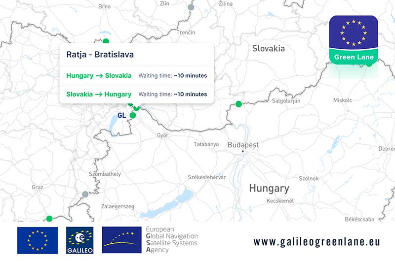
The European GNSS Agency (GSA) has collaborated with the European Commission to develop the Galileo Green Lane app, a mobile solution designed to facilitate the free movement of freight, reduce waiting times at European Union (EU) borders and prioritize essential goods during the COVID-19 pandemic response.
According to GSA, for border control authorities, the app provides a real-time visualization of the situation at border crossings, along with regular updates on the traffic flow situation.
For truck drivers, the app provides a real-time visualization of borders, through an EU-wide map indicating crossing times. This enables logistic companies and drivers to better prepare their routes, having advance knowledge of the waiting time at each border crossing, GSA said.
The app also offers a real-time overview of border traffic hold-ups, built on the foundation of Sixfold’s COVID-19 map. In mid-March, Sixfold began to provide supply chains, retailers and shippers with a free live border crossing map, which is updated in real-time.
“With the Galileo Green Lane app, the GSA is fulfilling its mission to address economic and societal challenges by leveraging the European GNSS capabilities,” said Pascal Claudel, acting executive director at the GSA.
The app has been tested at border crossings in Hungary and the Czech Republic, while other countries, including France, Greece, Italy, Romania and Spain, are about to start testing, GSA added.
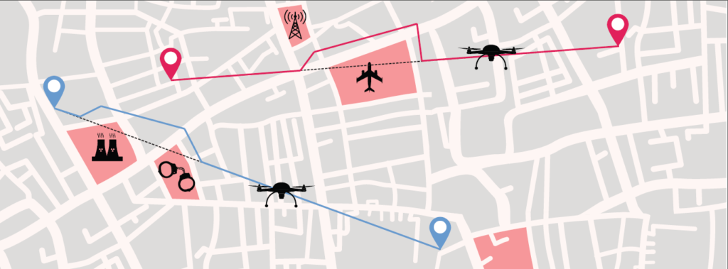
SUGUS — a European Commission project to promote European GNSS services for the integration of drones into the airspace — is conducting an online survey of stakeholders.
SUGUS, the European Commission’s project for the development of European GNSS (Galileo and EGNOS) services for U-space, is carrying out a survey to identify, gather and understand stakeholders’ needs, and to improve user experience of E-GNSS in complex operations and built-up areas.
U-space is a set of new services and specific procedures designed to support safe, efficient and secure access to European airspace for large numbers of drones.
SUGUS members invite all the stakeholders to take part in the survey, including suppliers of U-space services, manufacturers of unmanned aerial systems (UAS) platforms and GNSS receivers, UAS pilots and operators, public bodies, authorities and organizations, and centers for UAS testing and training.
The survey will be available until May 15.
The survey results will be used as a valuable input to tailor the E-GNSS Service Provision layer to specific drone missions’ needs, allowing a better mitigation of risks in complex operations like BVLOS (beyond visual line of sight) and UAM (urban air mobility), increasing safety and security.
Also, the points of view collected will help to define the requirements and then the implementation of a new E-GNSS-based API which will deliver live and forecast information about performance, coverage, alerts to users and more.
The API will be called upon by UTM service providers, UAS designers or UAS systems developers, and integrated in existing commercial solutions.
“The survey organized by SUGUS is a key element for E-GNSS Programs to capture user requirements of the drone community,” explained Miguel Aguilera, European Commission advisor. “The results will be used to enhance EGNOS and Galileo Service Provision targeting drone operations, increasing safety and security, and facilitating a swift and efficient deployment of U-space.”
SUGUS Project
SUGUS (Solution for E-GNSS U-Space Service) is a European Commission’s project to promote European GNSS services (EGNOS and Galileo) for the drone market and for the effective and safe integration of these aerial platforms in the airspace.
It is a European Union H2020 R&D project to be carried out by GMV (main contractor) with everis Aerospace, Defense and Security as co-leaders of a consortium also involving VVA Brussels, ESSP, FADA-CATEC and Unifly.
SUGUS will help to develop services geared towards the effective integration of drones into the airspace. A series of trials will be held to show the benefits of E-GNSS for drone operators, as well as its approval by aviation authorities.
Pierre Delsaux speaks at an EU breakfast on space policy . (Photo: European Union)
Responding to a suggestion about the Galileo outage this past summer to the effect of “these things happen,” a senior European Commission (EC) official pushed back strongly, calling the event “Unacceptable!” and vowing “Never again!”
The comments by Pierre Delsaux came during a question-and-answer session at breakfast hosted by the European Union on “EU Space Policy: Trends for the Future.” The breakfast was held as a parallel event to this year’s International Astronautics Conference in Washington, D.C.
Delsaux is the European Commission Deputy Director General in charge of space and defense industries. In his presentation, Delsaux described the success of a number of European space initiatives, stressing civilian use and applications and how they have benefited the world.
His comments highlighted a principle difference between Galileo and other GNSS systems including its being built and operated by an entirely civilian organization. With an accuracy of 20 centimeters, it exceeds other GNSS, he said. Also, that Galileo signals can be authenticated and trusted.
Delsaux’s remarks were especially pertinent and timely being made this week in the United States. A strategy document recently made public by the U.S. Department of Defense states that civil dependence on GPS has limited its use as a military tool. Because of this, new military PNT technologies will be “increasingly classified,” which is understood to mean “not shared with civil users.”
During the question-and-answer period, Delsaux was asked about criticism in the press this summer related to Galileo’s multi-day outage. European media outlets commented about poor communications and a lack of transparency during the outage, and the absence of a terrestrial backup system for when space is not available.
Rejecting the idea that such outages might be expected in such a difficult undertaking, Delsaux said that the event was unacceptable and “never again!”
While admitting things can always be done better, he thought that, given what was known with certainty at the time, a reasonable amount of information was made available.
Subsequent investigation has shown that the primary cause was an initial human error compounded by that person not taking the right corrective action.
Even with these compounded errors Galileo service would still not had been impacted, but for the mischance that this happened when a backup site was temporarily out of service.
Going forward, the European Commission is committed to being as transparent as possible about the results of the investigation, given security constraints.
Reinforcing the transparency message, other EC officials mentioned separately that Galileo personnel had given presentations about the outage at a recent Institute of Navigation Conference in Miami.
Delsaux did not respond to press criticism over a lack of a backup system (the title of a Der Spiegel article about the Galileo failure translates as “Who relies on a single system is stupid!”).
Later, other EC officials observed that that the European Radionavigation Plan recognizes that for critical applications, it is broadly accepted that GNSS, even multi-constellation and multifrequency, should not be the unique source of PNT information. For those applications, a complementary, alternative or backup solution should be maintained or developed.
The EC is still developing its approach to this issue.
Thales is leading the SESAR Joint Undertaking to research and develop new services for safe, efficient and secure access to airspace for drones.
The SESAR Joint Undertaking (SESAR JU) supports the European Commission’s U-space initiative by researching and developing new services for safe, efficient and secure access to airspace for an expected increase in drone use.
The Geosafe project is part of the founding services for the development of drones operation. Thales will manage the project, supported by Aeromapper, AirMap, Atechsys, Airmarine and SPH Engineering.
The 280 flight tests with 16 different drones will be conducted in France, Germany and Latvia. These tests will explore all possible situations that an automated drone will face in urban and rural areas.
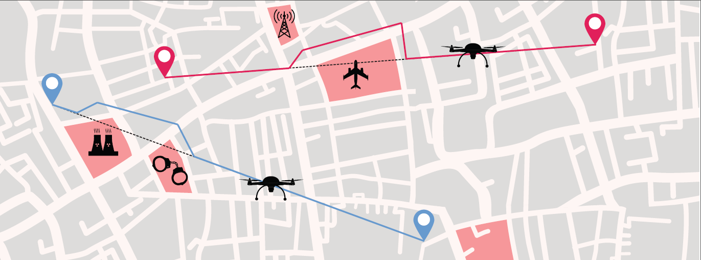
By securing the flight pattern of drones to avoid determined zones, geofencing solutions are key safety enablers. Geofencing ensures that drones don’t fly in protected perimeters around critical infrastructures, such as power plants or airports.
The objectives of Geosafe are to establish state-of-the-art geofencing solutions regarding U-space regulation and to propose improvements and recommendations for future geofencing system definition.
Geosafe will be based on a one-year-long flight-test campaign, assessing a number of commercially available geofencing solutions so that it can propose an improved geofencing system and technological improvements for automated drones.
Thales designs systems ensuring high security and safety levels for future air mobility. As the leader of the project, Thales will organize all tests and provide recommendations for the European geofencing system.
“Thales is playing a leading role in shaping the autonomous world,” said Christian Bardot, Thales VP in charge of Helicopter and UAV Avionics Business. “Together with SESAR JU and the Geosafe partners, we will strengthen the foundations of drones’ safe and secure operations, unleashing the potential of this tremendous market.”
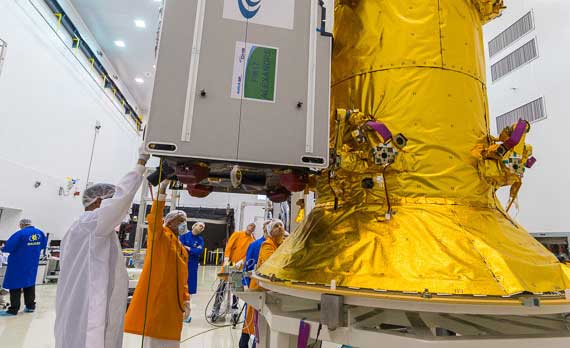
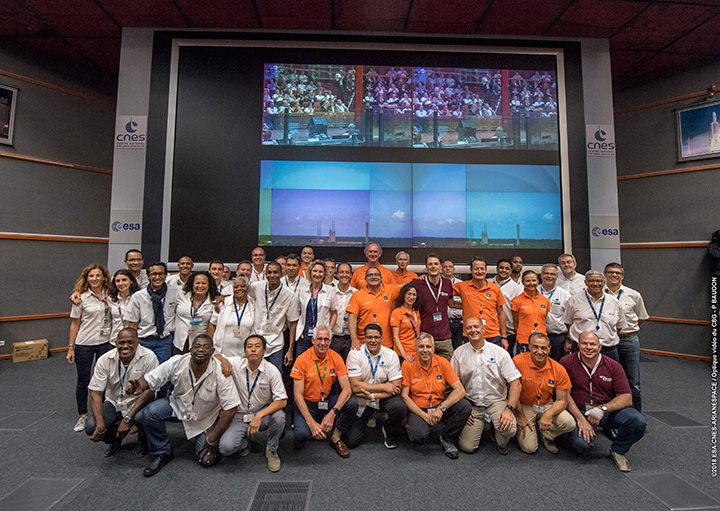
Countdown team at Kourou, Guiana control center for July’s four-satellite launch. (Photo: ESA/CNES/Arianespace, P. Baudon)
By Javier Benedicto Head, Galileo Programme department, European Space Agency
Since the declaration of initial services in December 2016, the European Space Agency (ESA) and the European GNSS Agency (GSA) have expanded Galileo’s system capabilities and service robustness with significant improvements of the ground segment and the last batch of four satellites launched by Ariane 5 in July. Once these satellites reach their final position and complete their in-orbit commissioning before the end of 2018, all 24 nominal slots of the Galileo constellation will be occupied.
Up to 22 satellites are planned to be commissioned in early 2019 and, eventually, the two FOC satellites injected in elliptical orbit should join the operational constellation after on-board software upgrade to provide for automatic health status flagging to users. This should lead to a total of 24 operational Galileo satellites supporting global PNT for users worldwide.
New Infrastructure Contracts
To further expand the system capabilities by 2020 and beyond, and reach Full Operational Capability (FOC), ESA has awarded new large industrial contracts in the context of the Exploitation Phase.
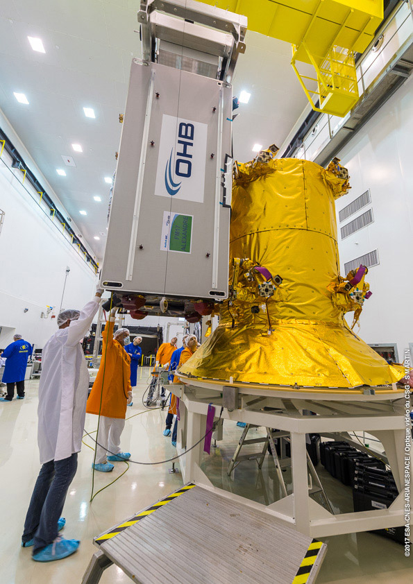
A contract to build and test another twelve Galileo satellites (so-called Batch-3) was awarded in 2017 to a consortium led by prime contractor OHB GmbH in Germany, with Surrey Satellite Technology Ltd in the UK as payload prime. These new satellites are based on the already qualified design of the previous Galileo FOC satellites. Production is advancing well, with first launch planned by late 2020.
With the Galileo constellation now expanded to 26 navigation satellites and plans to deploy additional Batch 3 satellites, the ground control infrastructure is undergoing a corresponding upgrades. In July, ESA awarded a new contract for the Galileo Ground Control Segment to GMV Aerospace and Defence, Spain. This contract includes upgrading the system architecture to manage a constellation of up to 41 Galileo satellites, updating obsolescent elements in the current system, improving operability linked to the provision of services and additional telemetry, tracking, and command capabilities to improve system robustness.
In October, Thales Alenia Space in France received a contract to upgrade the Galileo Ground Mission Segment and the Galileo Security Monitoring Centres (GSMC). This work includes upgrading Galileo’s system architecture to provide more accurate navigation products for broadcast by Galileo satellites, updating obsolescent elements in the current system and improving operability linked to the provision of services and enhanced robustness.
It will also include the construction of additional navigation message uplink and sensor stations. This contract will also augment the capabilities for implementation of the Public Regulated Service (PRS), the single most accurate and secure class of Galileo signals. Encrypted PRS signals will be made available only to authorized governmental users through approved national authorities. GSMCs in France and Spain will ensure the security monitoring functions for Galileo operational assets and manage PRS access and operations.
Growing Service Portfolio
The European Commission, GSA and ESA have jointly defined a broad range of service improvements and system capability enhancements to be deployed in 2019–2020, leading to FOC.
The newly qualified system infrastructure will support the broadcast of authentication information as part of the Open Service Navigation Message in E1; experimentation will start by end of 2019, leading to the possibility to offer trusted PNT to Galileo users.
Galileo will also be the first GNSS constellation to provide a Search and Rescue return link capability: as of 2019 the system will allow broadcast of acknowledgement of receipt message to users in distress with a very low latency, contributing to saving lives.
ESA has also started preparing the necessary modifications to the Navigation Signal Generation on-board the satellites to offer further capabilities to users after 2020. The signal-in-space will be enhanced with additional data transmitted in the I/NAV message, offering faster acquisition and more robust Galileo positioning on E1 and an encrypted navigation signal on E6 supporting authentication at signal level.
The new Galileo High Accuracy Service, soon entering the experimental phase, will consist in the delivery of un-encrypted high accuracy correction data in E6, enabling users to achieve sub-meter level positioning.
The usage of Galileo Open Service for aviation applications using horizontal advanced receiver-autonomous integrity monitoring techniques is being carefully assessed through measurements and review of the system design, including feared-events characterisation.
Longer Term Evolution
Galileo Second Generation has been the subject of technology pre-developments in the areas of platform and payload critical equipment, system techniques and processing algorithms, as well as system and segment Phase B studies over the past few years. We are now approaching the start of the implementation phase.
The European Commission, in close consultation with EU member states, has defined a decision roadmap aiming at very important future budget and programme implementation decisions in the course of 2019. In this context, ESA has launched a competitive procurement procedure for the first batch of so-called “Transition Satellites” with a broad range of enhanced and some new capabilities being considered. This includes improvements in the signal domain for faster acquisition and lower receiver power consumption, on-board clock technology, inter-satellite links, electrical propulsion, flexible payloads and power allocation by means of on-board digital technology and in-orbit re-configurability.
Transition satellites and related ground segment development contracts will begin by the end of 2019, aiming at in-orbit validation of second-generation capabilities from 2025 onwards.
EGNOS Evolution for Aviation
The adoption of Europe’s SBAS EGNOS by aviation is growing faster and faster. EGNOS will continue to evolve in the coming years. In particular, for 2019 and 2020, the evolutions under implementation focus on the obsolescence management of the hardware of some critical components, improvement of the system performances thanks to addition of new stations and system algorithms.
All these evolutions are planned to be qualified in 2021-2022, to continue to offer an excellent level of performance to Aviation Users until the operational take-over by the second generation of EGNOS V3,planned in 2025.
The European Performance-Based Navigation Implementing Regulation plans a growth from the current 35% to 66% in 2020 and 100% in 2024 of all European airports instrumental runways end-equipped with SBAS localizer performance with vertical guidance procedure.
On the aircraft manufacturer side, Airbus confirmed that it will continue equipping its aircraft; following the A350 family already equipped, both A320 and A330 families will be equipped for entry into service in summer 2020.
NAVISP
ESA’s Navigation Innovation and Support Programme (NAVISP), launched in 2017, will continue to boost member states’ industrial competitiveness and innovation in the upstream and downstream navigation sector, investigate the integration of satellite navigation with non-space technologies and complementary positioning and communication techniques, and study novel receiver-based techniques to counteract vulnerabilities and improve the robustness and reliability of GNSS.
Conclusion
The EU-built GNSS infrastructure systems EGNOS and Galileo are operational and serving users in Europe and worldwide. EC, GSA, ESA and European industries are committed to improvement plans over the next 2–3 years, with emphasis on endurance, resilience and robustness of the systems’ infrastructure, and delivering enhanced services.
For the longer term, the real challenge is to modernize the systems with new spaceborne and ground technologies, increase operational robustness and automation, and provide for additional system capabilities, while retaining a large degree of flexibility and in-orbit re-configurability to meet the long-term challenges and evolution of satellite-based navigation and timing.
The U.S. Federal Communications Commission (FCC) granted in part the European Commission’s request for a waiver of the commission’s rules so that non-federal devices in the United States may access specific Galileo signals. While private users were free to use the European GNSS, with this ruling entities such as telecommunications companies can now also use Galileo.
With today’s action, consumers and industry in the United States will now be permitted to access the E1 and E5 Galileo signals to augment GPS.
Since the debut of the first consumer handheld GPS device in 1989, consumers and industry in the United States have relied on the U.S. GPS to support satellite-based positioning, navigation, and timing (PNT) services that are integral to everyday applications ranging from driving directions to precision farming.
The order, approved Nov. 15, finds that Galileo is uniquely situated as a foreign GNSS system with respect to the U.S. GPS, since the two systems are interoperable and radiofrequency compatible pursuant to the 2004 European Union/United States Galileo-GPS Agreement.
Specifically, the order permits access to two of the Galileo system’s satellite signals — the E1 signal that is transmitted in the 1559-1591 MHz portion of the 1559-1610 MHz Radionavigation-Satellite Service (RNSS) frequency band, and the E5 signal that is transmitted in the 1164-1219 MHz portion of the 1164-1215 MHz and 1215-1240 MHz RNSS bands. These are the same RNSS bands in which the U.S. GPS satellite signals operate.
The order does not grant access to the Galileo E6 signal, which is transmitted over the 1260-1300 MHz frequency band, since this band is not allocated for RNSS in the United States or used by the U.S. GPS to provide PNT services.
The commission noted that granting access to the Galileo E6 signal could constrain U.S. spectrum management in the future in spectrum above 1300 MHz, where potential allocation changes are under consideration.