Screenshot from GSA video. See full GSA Flight Event 2015 video below.
News from the European GNSS Agency
Since its certification for civil aviation in 2011, EGNOS — the European satellite-based augmentation system — has been making flights in Europe safer, greener and more efficient. To celebrate this achievement and further promote EGNOS, the European GNSS Agency (GSA) in collaboration with the European Commission, invited the media and European aviation stakeholders for a unique EGNOS Flight Event in Toulouse, France, May 6-7.
Today, more than 140 airports in 15 countries across Europe benefit from EGNOS — with many more preparing for implementation. 171 LPV (localizer performance with vertical guidance) and 86 BARO approaches are already certified for use.
To highlight this impact, the EGNOS Flight Event, organized in collaboration with the European Commission, ESSP, ATR and Airbus, brought together aviation media and other sector stakeholders for a comprehensive briefing and demonstration of EGNOS, how it works and its significant benefits for the aviation sector. Along with flight demonstrations, the event assembled a unique array of EGNOS-experienced players — from pilots to operators, service providers and air traffic managers – to discuss how EGNOS is reshaping the future of air transportation in Europe.
Across-the-Board Benefits
Commercial, business and general aviation are all key market segments for EGNOS. For example, business and general aviation operators need to get to meetings as quickly and efficiently as possible, often requiring landing at smaller airports where Instrument Landing System (ILS) or other expensive ground-based navigation aids are simply not feasible. Thus, the implementation of EGNOS-based procedures at these airports significantly improves accessibility. “EGNOS, Europe’s first satellite navigation system, already has a good success story to tell,” says GSA Executive Director Carlo des Dorides. “EGNOS delivers continuous integrity protection in compliance with ICAO standards, allowing Cat I approaches with over 99 % availability. Today, 142 airports across Europe are benefitting from EGNOS — and the number is growing steadily.”
According to GSA Head of Market Development Gian Gherardo Calini, the Agency has the capacity to support airports and operators wanting to benefit from EGNOS. For example, this year the Agency has allotted €6 million to co-fund projects to implement EGNOS in aviation. A similar amount had also been allocated in 2014.
Airborne with EGNOS
Demonstrations of EGNOS included a briefing on EGNOS for rotorcraft and with the presentation of the GARDEN project. The project is using EGNOS to enable increased safety and better access for helicopters, for example, enabling air ambulances to access city centre hospitals. Participants were also given a first-hand look at EGNOS implementation in the cockpit of an Airbus H175 rotorcraft.
EGNOS in action was demonstrated by a series of flights using EGNOS for landing procedures with an ATR 42-600 turboprop, which was equipped with additional avionics in the main cabin so invited media could witness the technology at work. The flight demonstration took off from the Blagnac Airport in Toulouse, the venue for the EGNOS event, for a 15 minute circuit around Toulouse beforedemonstrating an EGNOS LPV approach and landing.
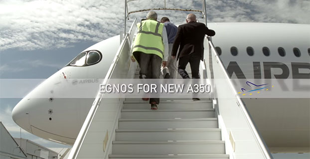
EGNOS for A350
A highlight on the tarmac was the Airbus A350WXB. Participants were given a tour of this new, state-of-the-art wide-bodied airliner — including a simulation of an EGNOS-enabled LPV landing in the cockpit. Airbus test pilot Jean-Christophe Lair described the A350’s new Satellite-based Landing System (SLS) that works with Satellite Based Augmentation Systems (SBAS) such as EGNOS. This is the first time such a system has been installed on a wide body airliner and will be supplied as a standard feature to customers.
According to Lair, EGNOS is fully integrated into a common, harmonised landing system interface on the A350 – the SLS. This allows the pilot to fly precision approaches like an ILS with geometrical vertical guidance down to 200 feet. This new navigation system will provide Airbus operators a wider range of solutions to optimise operations and increase accessibility without any compromise to safety.
EGNOS Expansion
The potential for expansion of EGNOS/SBAS is huge both in terms of global coverage and potential for use in Europe.
GSA Head of EGNOS Exploitation, Jean-Marc Piéplu, outlined the future upgrade of the system from the current Version 2 to EGNOS Version 3. “Version three will feature new capabilities, including dual frequency and dual-constellation with both GPS and Galileo,” he said.
This extension could potentially widen EGNOS/SBAS global coverage for aviation to over 90%. When asked about the timescale for this extension of coverage, Piéplu indicated that if the political will was there to implement, then this could be accomplished in 10 years as there were no outstanding technical issues.
According to International Council of Aircraft Owner and Pilot Association (IAOPA) Senior Vice President Martin Robinson, there is a huge potential for growth in Europe. Currently there are 4,649 aerodromes in Europe and some 50,000 general aviation aircraft operating. Compared to the US, only a fraction of these are SBAS enabled. In the US, the larger uptake of WAAS is due to a deliberate government-led industrial policy.
“Europe still lags behind the United States and there’s definitely room for growth,” said Robinson. “EGNOS will help to provide greater access to aerodromes throughout Europe and improve safety — but we need to be quicker if we are to realize these benefits sooner.”
It is heartening to see a burgeoning constellation and its operators move on from doubt to certainty, as Galileo prepares for fuller operational capability and the expectations that scope elicits.
To pick up the thread from last month’s column covering keynote speeches at the European Navigation Conference: plenaries subsequent to the opening session focused respectively on “GNSS for Aeronautical Applications: from GPS to Multi-Constellation with Galileo,” and “GNSS Resilience for Terrestrial & Naval Applications.”
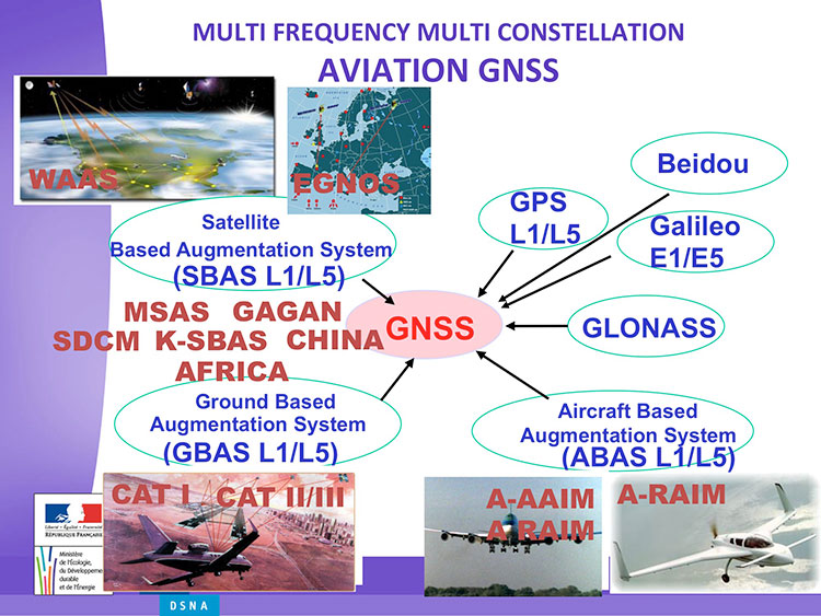
Avionics. Benoit Roturier, GNSS and Performance-Based Navigation program head for the French air traffic control agency, Direction des Services de la Navigation Aérienne (DSNA), reviewed the rather complex assembly of air navigation systems gradually coming together. Not quite — or not nearly — a system of systems, as I understand it, more a conglomeration of systems.
Slide from Benoit Roturier’s presentation on behalf of the French air traffic control agency. (Courtesy of Benoit Roturier)
Multi-constellation GNSS combos, with added context from satellite-based augmentation systems (SBAS), target provision of performance-based navigation (PBN) in all phases of flight, with increased robustness and availability, as well as escalating categories of precision approach and landing. Roturier presaged the SBAS message agreement that also took place in April with his observation that “[The] most benefits are achieved with two constellations — but which ones?” As four constellations and two frequencies deliver “many, many potential navigation modes,” how can air traffic controllers limit complexity while achieving maximum benefits? At the very least, there is a need to agree on main mode and reversion modes.
He gave an overview of upgrades planned, in progress, and completed at airports around France. 141 runways are as of January 2015 equipped with PBN, with GNSS and often EGNOS approaches, compared with 260 still relying on older systems. He concluded with a summary of DSNA views, including “SBAS/EGNOS is seen as a free of charge, performing, mature and here to stay technology, supporting navigation and surveillance (ADS-B) performance requirements.”
By the way, June’s EAGER enewsletter column will cover a recent EGNOS demonstration flight and the current state of runway approaches in Europe. Subscribe here for free.
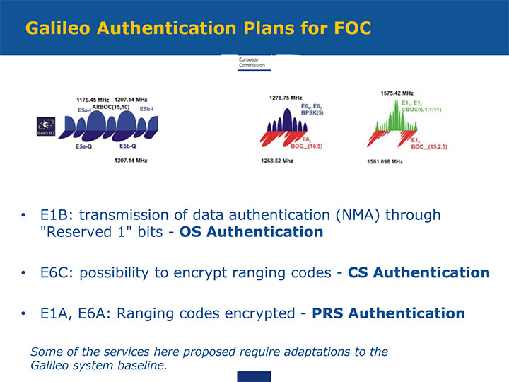
GNSS Resilience. The second plenary, on resilience, brought forth some of the most pointed commentary of the conference. Ignacio Fernández Hernández of the European Commission spoke on Galileo differentiators for resilience: its authentication plans for the Open Service, Commercial Service, and Public Regulated Service, respectively. “The proposed GNSS authentication services are 100 percent backward compatible and interoperable with other receiver-based technologies.”
Slide from presentation by Ignacio Fernández Hernández of the European Commission on Galileo differentiators for resilience. (Courtesy of the EC)
Hernandez proferred the caveat that “some of the required changes to deliver these services (particularly OS authentication) are pending on an impact analysis by industry/ESA and are not yet in the baseline. We hope however to have them in the baseline soon and we’re working hard for it.”
Matteo Paonni of the EC’s Joint Research Centre addressed spectrum management and regulatory issues, specifically the hot-button topic pseudolites. The EC is working closely with the United States and others to limit potential in-band interference risks. Outdoors, pseudolites are clearly undesirable; indoors, they offer some potential, but must be controlled.
Paonni stressed that there is a clear need to protect GNSS spectrum, and that the EC and its member states are doing their utmost to install such protections, and are also promoting GNSS radio-frequency interference detection and mitigation initiatives. Galileo’s PRS is more robust and resilient, but it is not invulnerable. GNSS vulnerabilities should be appreciated and backups put in place for critical systems; backups such as eLORAN, mini atomic clocks, GSM network, and so on.
Michel Monnerat of Thales Alenia Space focused on resilience in the road and LBS sectors. With a wide range of environments, devices and applications coming into play, “we need standardization” to specify levels of integrity and levels of performance for each different set of parameters. Thales Alenia is developing just such a set of performance requirements and references, with a first version set for release and discussion soon.
Slide presented by Michel Monnerat of Thales Alenia Space, which is working on a standardization protocol proposal, to be released soon. (Courtesy of Thales Alenia Space)
2015 GNSS Market Report: European GNSS Agency Provides a Fresh Look at Worldwide Growth
The fourth edition of the European GNSS Agency’s (GSA’s) GNSS Market Report provides a comprehensive source of knowledge on this dynamic global market. The report has become a key reference for organizations building their GNSS market strategies. The new edition provides:
Comprehensive updates on previous analyses;
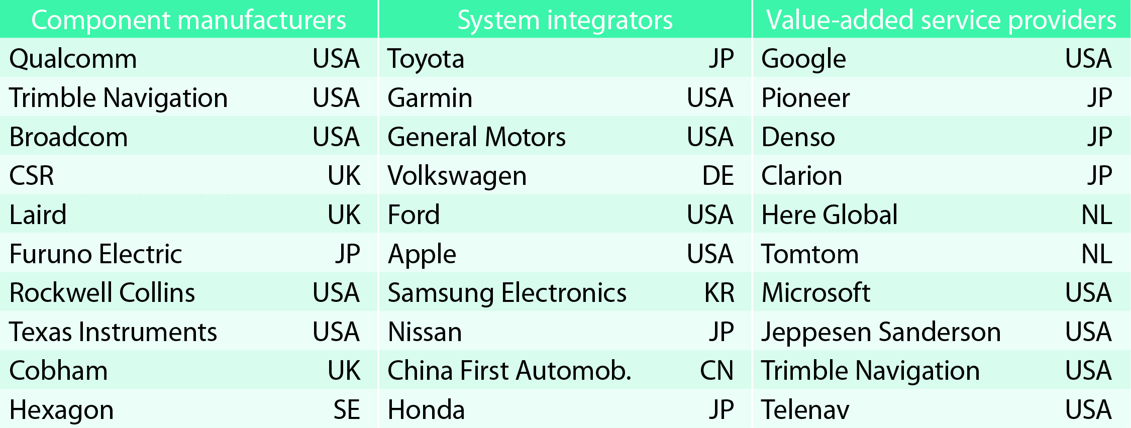
New statistics of the GNSS receiver capabilities of the 31 top global manufacturers, offering in total more than 300 models;
Insights on the GNSS industry and regional shares of the GNSS market
A more granular segmentation of the global GNSS market, namely: European Union (EU28); North America (including the United States, Canada, Mexico); Asia-Pacific (including China, Japan, Australia, India, Republic of Korea); Non-EU28 Europe (Norway, Switzerland, Russia, Ukraine); Middle East and Africa (Turkey, Israel, South Africa, UAE, Saudi Arabia); South America and Caribbean (including Brazil, Argentina, Colombia, Guatemala)
Information on a new market segment: Timing and Synchronization
Plus additional applications within existing segments, such as recreational navigation, fishing vessels, personal locator beacons, emergency locator transmitters and digital tachograph.
TABLE 1. Top 10 companies in each group based on 2012 revenue.
Key Findings
Top-line insights from the fourth GSA GNSS Market Report:
The global GNSS downstream market is forecast to increase by 8.3 percent annually from 2013– 2019, then slow down to 4.6 annually around 2023, growing on average faster (7 percent) than the forecast global GDP in this period (6.6 percent).
The installed base in the mature regions of EU28 and North America will grow steadily (8 percent per year) to 2023. The primary region of growth will be Asia-Pacific, which is forecast to grow 11 percent per year from 1.7 billion in 2014 to 4.2 billion devices in 2023 — more than the EU and North America together. The Middle East and Africa will grow at the fastest rate (19 percent per year), but starting from a lower base.
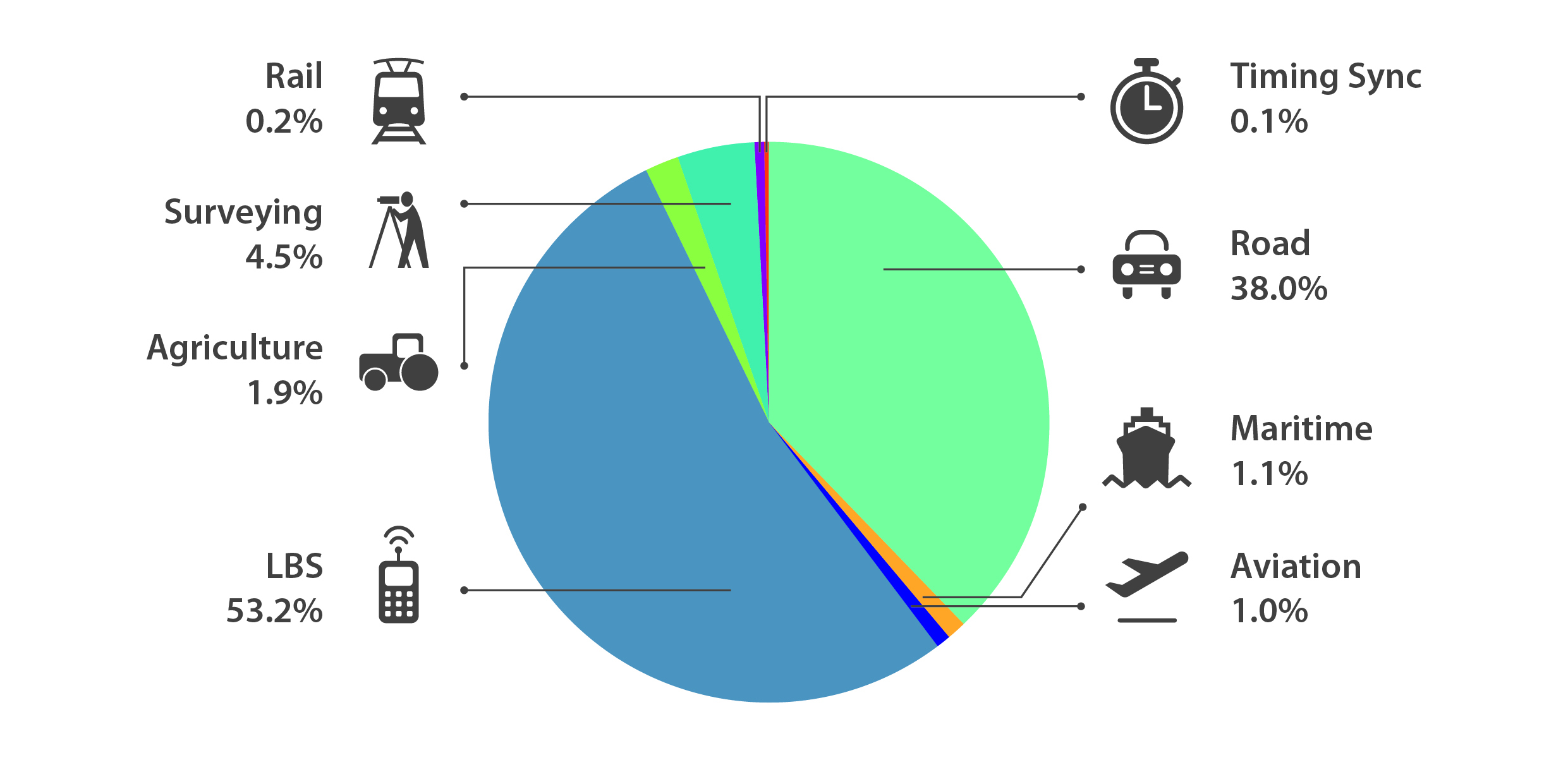
Location-Based Services (LBS) and Road dominate cumulative GNSS revenues, driven by booming sales of smartphones and in-vehicle devices, location-aware applications and data services.
With emerging economies catching up in terms of GNSS devices per capita, the Digital Divide will narrow, driven by the take-up of smartphones. The growing dominance of smartphones (3.08 billion in 2014) is foreseen as the most popular platform to access LBS.
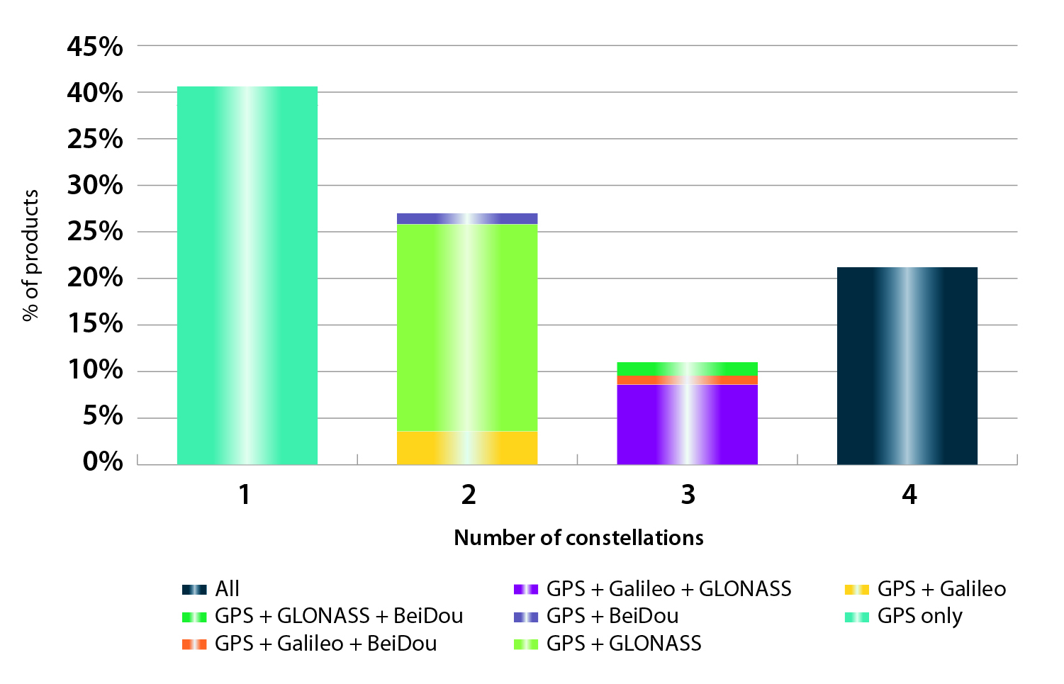
In the analysis of the capabilities of GNSS receivers and chipsets, it is reported that more than 60 percent of currently available receivers and chipsets support a minimum of two constellations with more than 20 percent supporting all four of them.
FIGURE 2. SUPPORTED CONSTELLATION BY RECEIVERS Chart shows the percentage of available receivers capable of tracking signals from one GNSS (such as GPS only), two GNSS (GPS + Galileo, GPS + GLONASS, GPS + BeiDou), three GNSS (GPS + Galileo + GLONASS, GPS + Galileo + BeiDou, GPS + GLONASS + BeiDou) or tracking signals from all constellations at the same time. The percentages add up to 100 percent. We can conclude that almost 60 percent of all available receivers, chipsets and modules are supporting a minimum of two constellations, showing that multi-constellation is becoming a standard feature across all market segments.
New Charts
The report includes new infographics presenting:
Global GNSS downstream market size, core and enabled (2013 to 2023)
GNSS industry share by region (2012)
The global shares of companies among components manufacturers, systems integrators and value-added service providers (2012)
Capability of GNSS receivers and chipsets, all segments (2015)
Supported constellation by receivers and chipsets , all segments (2015)
Detailed analysis of key GNSS segments: LBS, Road, Aviation, Rail, Maritime, Agriculture, Surveying, Timing and Synchronization, quantified in terms of:
Shipments of GNSS devices by application and region (2013 to 2023)
Installed base of GNSS devices by application and region (2013 to 2023)
Core revenues from GNSS device sales by application and region (2013 to 2023)
Capability of GNSS receivers and chipsets (2015)
Supported constellation by receivers and chipsets (2015).
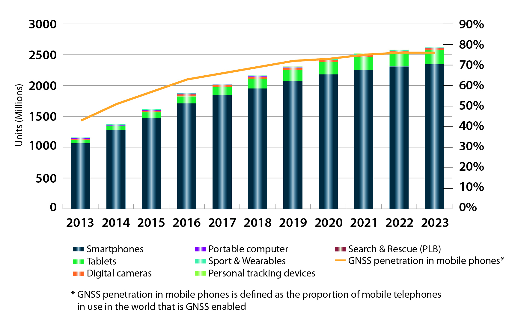
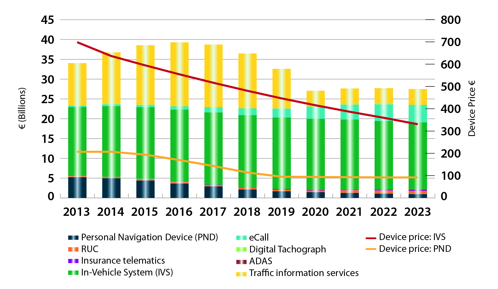
FIGURE 3. LOCATION-BASED SERVICES SECTOR GNSS shipments by type; GNSS penetration in mobile phones is defined as the proportion of mobile telephones in use in the world that is GNSS enabled.FIGURE 4. ROAD SECTOR Core revenue from GNSS device sales and services by application.
Methodology
The “GSA GNSS Market Report” is compiled by the GSA and the European Commission and was produced using the GSA’s systematic Marketing Monitoring and Forecasting Process.
The underlying market model uses advanced forecasting techniques applied to a wide range of input data, assumptions, and scenarios to forecast the size of the GNSS market in terms of shipments, revenue and installed base of receivers.
Historical values are anchored to actual data in order to ensure a high level of accuracy. Assumptions are provided by expert opinions and model results are cross-checked against the most recent market research reports from independent sources, before being validated through an iterative consultation process with sector experts and stakeholders.
Galileo 7 and 8 launch on March 27. The Galileo satellite navigation system remains on track after successful in-orbit validation and the salvage for navigational testing of two satellites launched into an incorrect orbit. The mini-constellation of satellites in orbit plus their associated ground segment has allowed in-depth testing of the overall Galileo system, and the performance was good. Now with the launch of the latest pair of satellites, ESA and the European Commission are progressing with the deployment phase of the program.
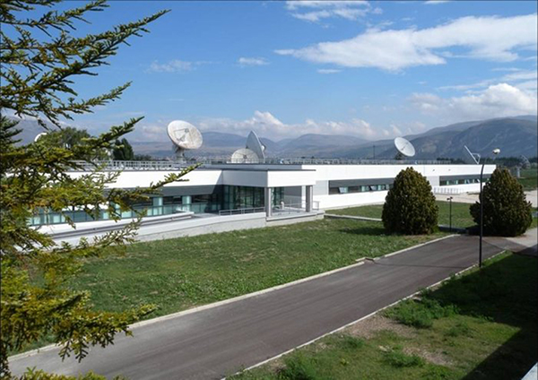
Galileo’s Ground Mission Segment in the Fucino Control Centre in Italy oversees Galileo navigation services and satellite payload operations.
News from the European Space Agency
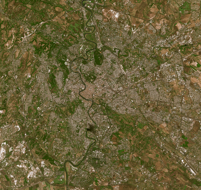
In Roman times the milestone was the central method of navigation, with all distances fixed from a ‘golden milestone’ in the imperial capital. Today, navigation satellites have become the modern equivalent of milestones — but Rome still has a role to play.
Inside the Galileo System Evaluation Equipment facility, based at Thales Alenia Space in Rome.
The Thales Alenia Space plant in the eastern suburbs of Rome is home to the Galileo System Evaluation Equipment facility, which provides a troubleshooting platform for the Galileo ground network and an assessment of the performance of Europe’s under-construction satnav constellation.
Based in the main plant building, it is equipped with a secure data link to the Galileo Control Centre in Fucino, 90 km away, which oversees Galileo navigation services. This link gives it direct access to all the data gathered by the global ground segment, from the sensor station data to the navigation messages uplinked to the satellites, including satellite orbits and onboard clock corrections.
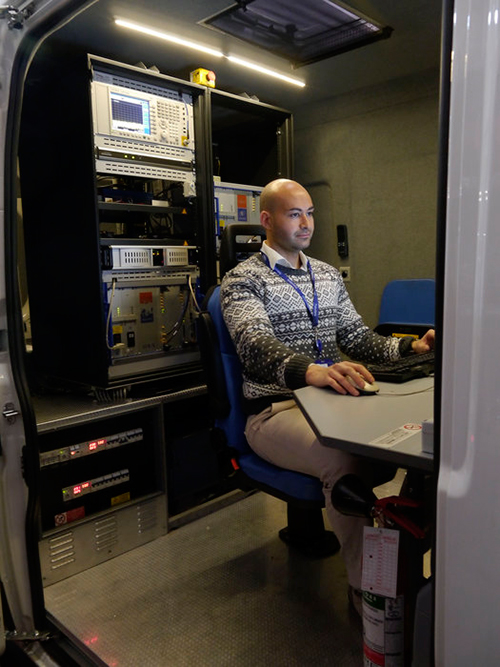
The facility can then apply separate software to these inputs, rather than that used in the Galileo Mission Segment, to provide a “second opinion” on Galileo performance. In addition, a van measures Galileo performance in the field, gathering data across a range of vehicle and rural environments.
The River Tiber flows through the historic centre of Rome, seen in high-resolution detail by France’s Spot-5 satellite.
“The facility is being routinely operated by the Thales Alenia Space team,” explains Enrico Spinelli, overseeing it on the ESA side. “It is being upgraded to automatically process the data received from the Galileo control centres, perform troubleshooting analyses and provide inputs for the monthly Early Service Key Performance Indicators report. These reports are provided in turn to the European Commission’s European Global Navigation Satellite System Agency, as part of Galileo’s Early Services preparatory activities.”
The facility made the Rome area one of the two main centres of activity during Galileo’s In-Orbit Validation phase, along with the ESA’s ESTEC technical centre in Noordwijk, the Netherlands. In-Orbit Validation was the extensive system testing performed on the ground during late 2012 and early 2013 to ensure the embryonic four-satellite system was performing as designed, including Galileo’s historic first position fix of longitude, latitude and altitude on March 12, 2013.
The Galileo System Evaluation Equipment facility hosted at Thales Alenia Space in Rome is equipped with a van measures Galileo performance in the field, gathering data across a range of vehicle and rural environments.
“The facility was developed for that phase, but has performed so well that it was decided to keep it in operation during succeeding phases,” adds Enrico. “Along with its intended use in monthly reporting, its direct access and processing of Galileo Control Centre data will make it a powerful tool for system troubleshooting for both Galileo’s upcoming services. It can give us independent analyses of factors such as the availability and quality of data from Galileo Sensor Stations and the Orbit Determination and Time Synchronisation process which keeps the overall Galileo system in sync.
“It can also allow us to check the accuracy of software models used to compensate for ionospheric delay, the accuracy of almanacs charting satellite orbital positions and to analyze the efficiency of the ground-to-satellite contact plans for the uplink of the navigation message which the satellites rebroadcast, even to verify the navigation message is being broadcast in its correct structure.”
The improved facility should help to ensure the timely and reliable introduction of initial Galileo services, planned in 2016.
On November 18, a Consultation Event will take place in Brussels on the subject of receiver technology. The event is being held to inform the stakeholders of the European GNSS receiver community about the format and timeline of funding opportunities for the period 2015-2020, and to gather input for the definition of R&D actions in the field of receiver technology.
The workshop will consist of one panel session, during which stakeholders from industry, SMEs, academia, and technology institutes will be asked to debate and recommend important lines of research in receiver technology.
Registration is now open on the Europa website. Interested participants are invited to fill in the registration form and to indicate which application area they are interested in and the fields of research that should be supported.
The workshop will be held at the Committee of the Regions, Jacques Delors building, rue Belliard 99-101, room JDE 53, Brussels.
The European GNSS Agency (GSA) and the European Commission have concluded an agreement that delegates a range of exploitation tasks for Galileo to the GSA, providing a framework and budget for the development of services and operations through 2021.
The signing of the Galileo Exploitation Delegation Agreement serves as an initial step towards the full Galileo Exploitation Phase.
According to the governance structure set out in the Agreement for the Galileo programme, the European Commission is responsible for the overall programme supervision, the European Space Agency (ESA) is entrusted with the deployment phase, while the GSA is responsible for the exploitation phase.
As to the exploitation phase, the GSA’s responsibilities include:
Provision and marketing of the services
Management, maintenance, continuous improvement, evolution and protection of the space and ground infrastructure
Research and development of receiver platforms with innovative features in different application domains
Development of future generations of the system
Cooperation with other GNSS
All other required activities to ensure the development and smooth running of the system
“With Galileo, we aim to provide a tangible service to European citizens, and this Delegation Agreement ensures we have the tools and funding necessary to achieve this,” said GSA Executive Director Carlo des Dorides.
The Galileo exploitation phase will be progressively rolled out starting in 2014-2015, with full operability scheduled for 2020.
The agreement was signed between Daniel Calleja Crespo, director-general of the Enterprise and Industry Directorate-General at the European Commission and Carlo des Dorides, executive director of the GSA. The agreement specifically sets the actions to be implemented, the amount of funding provided, and the conditions for the overall management.
The implementation period of the agreement runs until 2021, with a comprehensive review of its functioning by the end of 2016. The maximum current EU contribution amounts to EUR 490 million, which will cover procurement and grant activities, including the GSA-ESA working arrangements and a programme management reserve, along with related research and development activities. The financing of the full exploitation phase will be confirmed during a mid-term review before the end of 2016.
In May 2011, Dinesh Manandhar and Hideyuki Torimoto of GNSS Technologies, Inc., Japan, penned a very interesting article in GPS World titled – Opening Up Indoors: Japan’s Indoor Messaging System, IMES. The opening paragraph of their lengthy article seemingly describes the Holy Grail for the indoor positioning lobby:
“An indoor messaging system (IMES) has been developed to meet the challenges of indoor and deep indoor positioning, as a system that can be implemented in any device that has a GPS/GNSS receiver without hardware modification. IMES can provide reliable 3D position data with a single transmitter device without performing range calculation[s].”
They go on to describe the IMES concept thusly:
“The main concept of IMES is to transmit position and floor ID of the transmitter with the same RF signal as GPS. IMES transmits latitude, longitude, height, and floor ID by replacing the ephemeris and clock data in the navigation message of GPS. A single unit of IMES is enough to get the position data, since the position itself is directly transmitted.”
Now, you don’t have to be a rocket scientist to start thinking about interference and spoofing issues or risks, especially when you read that the navigation message ephemeris and clock data are being replaced by data broadcast by IMES. To be fair, the authors address these issues briefly:
“Since IMES shares the same frequency as [the] GPS L1 band (1575.42 MHz), there is an interference level that IMES may have on GPS signals. This interference has been studied in detail by conducting experiments and simulations. Based on these studies and analysis, various methods have been considered to avoid harmful interference to GPS signal. To avoid such interference, IMES center frequency is shifted by +/– 8.2 KHz from GPS L1 band. This will have the least impact on the GPS L1 band signal. For example, if the IMES signal is –110 dBm (very strong) and the GPS signal is –142 dBm (very weak), the loss of GPS signal (C/N0) due to IMES is less than 2 db. If the IMES signal is –120 dBm and the GPS signal is –142 dBm, there is no loss of GPS signal (C/N0). Based on this analysis, the IMES transmitter power must be controlled such that the maximum power to the receiver does not exceed –110 dBm at a distance of 3 meters from the transmitter. [There are] guideline[s] specified in the QZSS IS document for setting the transmitter effective isotropic radiated power (EIRP) based on location.”
Let’s put these concerns in perspective. I thoroughly enjoyed the article and firmly believe that we desperately need to solve the indoor positioning and navigation problems, especially for our warfighters and first responders. While many of today’s excellent commercial receivers work well indoors near windows and doors, they are absolutely abysmal underground and deep inside large buildings with lots of metal, or in the middle of dense urban canyons such as Tokyo, Japan. Without a doubt, there is a dire need for a system like IMES — or maybe exactly like IMES — but there must be some caveats and stipulations as to how the IMES system is implemented.
Not Alone
Fortunately, I am far from being a lone wolf in voicing my concerns and my position, for once again the conspiracy theorists as well as renowned scientist and policy makers are concerned about IMES and the operating systems they supposedly desire to replace or augment. Chief among them is the Father of GPS, Dr. Bradford Parkinson, who has frequently described improperly operated in-band pseudolites as “…just another name for a legal jammer or spoofer.” Having known Brad for almost 40 years, I am convinced few GPS experts in the world today have as much experience with pseudolites as Dr. Parkinson. Consequently, the very reason that an indoor navigation system such as IMES is needed may well be a portent for why it may well fail, unless it is implemented properly.
It would be easy but extremely tedious to write about the numerous issues facing IMES in a complicated and technical manner. Certainly previous articles have become bogged down in minutia, and I want to avoid that. It is actually very simple. The issues are fairly straightforward and should be faced head on and not hidden in the midst of tech-speak lingo, legal jargon, policy minutia or politics. So lets dive straight in, shall w,e and make sure these issues see the light of day?
Interference
There can be no doubt that IMES has the potential to significantly interfere with GPS and QZSS signals. The authors of the IMES article are quite clear concerning the potential for interference, and in their own way attempt to mitigate it with signal power restrictions. Their example of a small three- to four-story building with IMES transmitters may indeed be adequate for signal power mitigations, but what happens in Tokyo where tall buildings — skyscrapers if you will — abound? When the Tokyo Skytree skyscraper opened to the public in 2012, it was then listed as the world’s tallest tower and Japan’s biggest new landmark. At over 2,080 feet tall, this is definitely the type of building where one would need an IMES system. With an average of 20 IMES transmitters per floor and weighing in with over 200 floors, we can quickly see that there would be over 4,000 IMES transmitters in this one building alone, all broadcasting simultaneously on or near the center frequency for GPS. Absent stringent regulations and infinite care (the IMES article authors propose that the pseudolite network operator will have the responsibility to continuously monitor each pseudolite and the pseudolite network to prevent interference), and perhaps even with those caveats in place, the GPS L-band noise floor would be such that GPS signals would be incapable of being received.
Now, put 20 such buildings in a ten-block area and the noise floor would be almost incalculable and certainly not predictable. Dr. Parkinson’s fears are realized; your legalized IMES system becomes a distributed network of jammers and/or spoofers. However, technically IMES is currently far from being a legal jammer or spoofer as currently IMES transmitters are not legal to operate in the GPS band at 1559-1610 MHz under the International Telecommunications Union (ITU) Treaty per the International Table of Frequency Allocations of the ITU Radio Regulations. The ITU further states that IMES currently operates on an interfering basis with the co-primary allocations (ARNS/RNSS) in this band, and therefore are in violation of the ITU Treaty. However, Japan’s frequency regulatory agency can develop and implement regulations that allow IMES operations. When this occurs, if not operated within stringent guidelines, IMES could then be considered a legalized jammer or spoofer.
Even the Joint Research Centre of the European Commission, the JRC, states in its Executive Summary on pseudolites that in-band pseudolites pose a significant jamming risk to GNSS receivers. Specifically they state:
Pseudolites or pseudo-satellites are an emerging technology with the potential of enabling satellite navigation indoors. This technology found several applications that are not limited to indoor navigation. Precise landing, emergency services in difficult environments and precise positioning and machine control are few examples where pseudolite technology can be employed.
Despite the great potential of this technology, severe interference problems with existing GNSS services can arise. The problem can be particularly severe when considering non-participating receivers — legacy devices not designed for pseudolite signals. The design of pseudolite signals is thus a complex problem that has to account for market requirements (modifications of existing receivers for enabling the use of pseudolite signals, measurement accuracy, target application), regulatory aspects (frequency bands to be allocated for pseudolite services) and interference problems.
JRC investigates the main aspects to be considered for the design of a pseudolite signal standard minimizing the interference problem without compromising the location capabilities of the system. The focus is on the signal characteristics and topics relevant for the signal design.
Pseudolite or Communications System
The second technical portion of the interference issue revolves around how exactly you define IMES, for when you are dealing with radio regulation agencies semantics matter. Think back to the first paragraph of this article where the IMES authors defined IMES as a messaging system. That certainly sounds like a communications system to me, and others agree. Consequently, the question has been raised and rightfully so: Is IMES a navigation and positioning system, a pseudolite or a communications system? Honestly, to me it sounds like a bit of all three, but if you define it as a communications system, then Japan is seeking to authorize the integration of a communications system with known significant interference issues with GPS signals right in the middle — indeed, potentially on the center frequency of the protected navigation band using terrestrial PRN codes assigned by the U.S. government. If IMES is deemed an indoor pseudolite, then the interference issues are still there. But it is defined as a bonafide PNT system using authorized terrestrial PRN codes. Talk about a bucket of worms!
The issues here are numerous, and they need to be fully addressed to ensure that all those who are potentially affected clearly understand what is being proposed and the risk for the public at large, including who owns responsibility if something goes wrong. I could go on for several pages on this issue alone, but suffice it to say, we do not want to authorize a communications system that is a known and acknowledged GPS interferer right in the middle of the band — or anywhere in the band for that matter. Remember all the issues GPS had in the past several years with a communications system in adjacent bands. So, do we really want a known communications system — or communications system masquerading as a pseudolite, for that matter — with known GPS signal interference issues in the restricted GPS frequency spectrum? The blaringly obvious answer is absolutely not! Yet this is exactly what the IMES authors are proposing not only for Japan, but eventually, if they receive authorization, for other countries around the globe as well. Japan has twice petitioned the U.S. government to make the assigned IMES terrestrial PRN code allocations global in nature. Fortunately, to date those request have been denied.
Dichotomy
Certainly, other countries and companies have noticed this apparent frequency authorization dichotomy and are following suit. For instance the Conference of European Postal and Telecommunications agencies, or CEPT, which is Europe’s regional representative to the World Radiocommunication Conference (WRC), has proposed adding several troubling IMES-related agenda items for the quadrennial WRCs coming up in 2015 and 2019. Even more importantly, these critical issues could be aired in the next three weeks, as the agenda for the 2015 WRC will be largely set at a plenipotentiary conference happening October 20 through November 8 in Busan, South Korea.
There are what I consider to be dangerous proposals under consideration by the ITU (International Telecommunication Union), which should concern GNSS users worldwide. The ITU is the United Nations’ specialized agency for information and communication technologies — ICTs. This is the ITU, where every member state (currently 193) gets one vote, whether they fully understand the technical issues or not and regardless of whether they are a space-faring nation or have a dog in the fight, so to speak. This means that the vote of tiny Saint Lucia counts the same as the United States or Canada or Australia. The ITU charter is to “…allocate global radio spectrum and satellite orbits, develop the technical standards that ensure networks and technologies seamlessly interconnect, and strive to improve access to ICTs to underserved communities worldwide.” Fortunately, the ITU regulations, unlike the CEPT or IMES proposals, wisely require new transmitters proposing to operate in the radio navigation spectrum to operate without causing interference to primary users. Meanwhile, there are member states, countries and companies that want to capitalize on this seeming dichotomy within the global safety-of-life, historically protected, radio bands. Those nefarious efforts, for the future of GPS and GNSS worldwide, need to be stopped in their tracks.
Spectrum is a limited and valuable resource, to say the least, and here fortunately the ITU regulations have it right and do not risk human life, by intruding and potentially interfering with the frequencies used globally by airliners to control, route and land aircraft. I am convinced there are solutions available to us through cooperative efforts with the ITU and other national organizations that will produce pseudolites without causing interference in the protected safety-of-life frequency bands.
When Is a PRN Code Not a PRN Code?
Some of you who are a bit more savvy or have been following this fiasco for some time may now be thinking, what’s the problem, the IMES authors are merely using and proposing further use of U.S. government-authorized terrestrial PRN codes for IMES. This indeed touches on the third thorny issue, which is not only technical but political as well — the use of and authorization to use PRN codes for what is ostensibly a communications system, if you believe the authors of the IMES article, who go to great lengths to differentiate IMES from pseudolites. They continually make the argument that IMES is not a pseudolite, but as we shall soon see, when the U.S. government authorized these specific PRN codes (173-182) for Japan, they were to be used solely for a low-power terrestrial pseudolite program, not an in-band communications system.
Technically, these specific PRN codes assigned to the Japanese for IMES expire in 2017. The authorization of these PRN codes come with numerous restrictions that legally make the codes useful only for the Japanese landmass. This is where the technical, political and operational issues come to a head. We are in for some tough sledding here. However, I will endeavor to make it as simple as possible.
History
In 2007, ten PRN codes were specifically assigned to the Japan Aerospace Exploration Agency or JAXA “for the Indoor Messaging System (IMES) terrestrial pseudolites of the Quasi-Zenith Satellite System (QZSS).” The Memorandum of Agreement from the GPS Wing at SMC (Space and Missile Systems Center) in Los Angeles at Los Angeles Air Force Base (LAAFB) clearly states that the codes are valid for ten years and expire on 19 November 2017, unless a renewal application is filed and approved. Hence, PRN codes 173-182 for IMES were assigned with several crucial caveats and restrictions by the U.S. government that are definitely pertinent to our discussion:
The codes are designated for low-power terrestrial regional applications limited to Japan only.
Although the GPS Wing conducts an initial check on PRN number requests with respect to potential interference issues, the issuance of a PRN number does not convey authority to radiate in the [GPS] band. In order to radiate in the GPS L1 band, the applicant [Japan] shall obtain a frequency assignment from the [Japanese] national authority.
The GPS Wing assumes no responsibility for ensuring systems using these spreading codes follow domestic radio frequency regulations or other applicable laws or regulations, or for ensuring that systems using GPS PRN codes do not cause radio frequency interference.
GPS PRN codes were developed for signals transmitted from satellites, and are not necessarily optimized for use by terrestrial transmitters.
The maximum effective isotropic power for each terrestrial transmitter will be less than -94 dBW.
The QZSS [organization] is responsible for the redistribution of these spreading codes throughout Japan and will limit their use to Japan only.
With all these restrictions, it is difficult to see how the IMES authors could legally use, distribute or promote authorization of IMES and the use of the PRN codes outside of Japan and at the power levels related in the GPS World IMES article. Regardless of the IMES author’s interpretation of the PRN code assignment, the GPS Wing 2007 Memorandum restrictions and caveats are clear, and it cannot be disputed that the codes expire in 2017 unless renewed by the USAF. The PRN codes are restricted to the landmass of Japan even if they are renewed, and if IMES wishes to broadcast anywhere in the GPS band, they need to have permission from their national frequency allocation authority (the Ministry of Internal Affairs and Communications, which is equivalent to the U.S. FCC –Federal Communications Commission) to do so.
The Way Ahead
This is the easy part from my perspective. See if you don’t agree. If the U.S. government is concerned about IMES and what Japan is planning to do with the assigned PRN codes for terrestrial use, the U.S. government through the USAF has the options to:
Rescind the PRN codes immediately.
Insure the Japanese adhere to the caveats and restrictions in the original Memorandum.
Simply refuse to renew or recertify the codes for future use and/or recommend for IMES frequencies that are outside the protected GPS band.
Update and clarify the footnote on the GPS Wing PRN Codes website pertaining to the Japanese IMES PRN Codes with all the restrictions listed in the GPS Wing Memorandum so other countries will realize this is not a global IMES PRN assignment.
Japan is a valuable ally and we need to work together cooperatively, but frankly, the plans laid out for IMES by the authors in the GPS World article must be troubling to those whose job it is protect the GPS spectrum and enforce mutual agreements with our allies. If we were just concerned about a Japanese IMES system, this whole discussion might be moot. However, other countries and commercial companies around the world are watching closely and laying the groundwork for similar IMES and pseudolite incursions into the GPS L-band spectrum — if the Japanese are allowed to proceed and the limited use of PRN codes for IMES is not clarified for all. No one, and I include the Japanese, wants to see this happen if it means interference with GPS, and QZSS for that matter.
Fortunately, where European countries are concerned, there are the ITU regulations. Specifically for GPS and pseudolites, the CEPT regulation has a license condition that requires the pseudolite network operator to submit to the European country regulator confirmation of the terrestrial PRN codes from the GNSS operator before operating pseudolites in the GPS band. So again, the U.S. government wields the hammer here.
Therefore, the U.S. government must act immediately and decisively to put an end to the threats against the protected GPS spectrum caused by the proposed in-band IMES system. At the same time, the Japanese government has an obligation and responsibility to adhere to the letter of the law where the original GPS Wing 2007 IMES Memorandum is concerned.
Finally, the U.S. government must urgently engage cooperatively with the European Union administration and Japan to prevent the authorization and proliferation of interfering devices in the GNSS frequency bands, and to work together to ensure the positive benefits to GNSS from commercializing pseudolite uses outside the GNSS radio frequency bands. GNSS manufacturers worldwide are successfully marketing commercial pseudolites that do not cause interference. In my opinion, this is the way to go both in terms of regulations and governance.
Until next time, happy navigating, and remember GPS is brought to you free of charge by the United States Air Force.
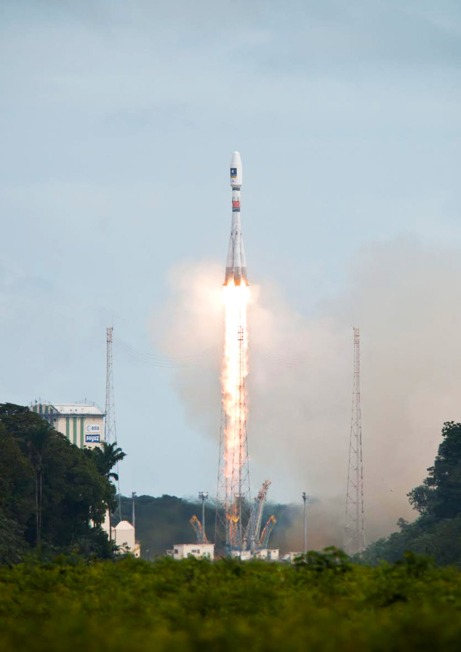
Following the major anomaly that occurred on August 22 during the Soyuz ST mission carrying two satellites in the Galileo constellation, Arianespace announced today, in conjunction with the European Space Agency (ESA) and the European Commission, the appointment of an independent inquiry commission.
The commission is chaired by Peter Dubock, former ESA Inspector General. Its mandate is to establish the circumstances of the anomaly, to identify the root causes and associated aggravating factors, and make recommendations to correct the identified defect and to allow for a safe return to flight for all Soyuz launches from the Guiana Space Center (CSG).
The commission will start its work on August 28 and submit its initial conclusions as early as September 8.
The inquiry commission comprises the following members:
Peter Dubock, former ESA Inspector General, Chairman;
Professor Guido Colasurdo, University of Roma “Sapienza”, full professor of flight mechanics;
Michel Courtois, former ESA Technical Director;
Paul Flament, European Commission, Head of Unit, Galileo and Egnos Programmes Management, DG for Entreprise and Industry;
Giuliano Gatti, ESA, Galileo Program Technical Officer;
Professor Wolfgang Kubbat, former head of the Institute of Flight Systems and Automatic Control at the Technical University of Darmstadt;
Isabelle Rongier, CNES Inspector General;
Toni Tolker Nielsen, ESA Deputy Inspector General.
To maintain links with the Russian partners in the Soyuz at CSG program, the head of the Russian space agency Roscosmos, on request from the head of Arianespace, has designated Alexander Daniliuk, Deputy Director General of TsNIImash, as board liaison.
Arianespace Chairman and CEO Stéphane Israël said: “I would like to thank Peter Dubock for having accepted the chairmanship of this commission, which was appointed in conjunction with ESA and the European Commission and with the support of the space agencies from France (CNES), Germany (DLR) and Italy (ASI), along with a team of high-level European experts. The commission will now be able to carry out its work independently, operating under a very tight schedule. We sincerely hope that the commission’s recommendations will lead to a rapid resumption of missions, while ensuring the high reliability expected of our Soyuz launches from CSG.”
After the separation of the two Galileo satellites launched August 22, ongoing analysis of the data provided by the telemetry stations operated by the European Space Agency (ESA) and the French space agency CNES showed that the satellites were not in the expected orbit.
According to the initial analyses, an anomaly is thought to have occurred during the flight phase involving the Fregat upper stage, causing the satellites to be injected into a noncompliant orbit.
The liftoff and first part of the mission proceeded nominally, reports Arianespace, leading to release of the satellites according to the planned timetable, and reception of signals from the satellites. However, the targeted orbit was circular, inclined at 55 degrees with a semi major axis of 29,900 kilometers. The satellites are now in an elliptical orbit, with excentricity of 0.23, a semi major axis of 26,200 km and inclined at 49.8 degrees.
Both the Fregat upper stage and the two satellites are in a stable condition and position that entails no risk for people on the ground. The residual propellants on the Fregat stage have been purged and the stage was depressurized normally.
Studies and data analyses are continuing in Kourou, French Guiana, and at Arianespace headquarters in Evry, near Paris, under the direction of Stéphane Israël, Chairman and CEO of Arianespace, in conjunction with the Russian partners in the Soyuz in French Guiana program (Russian space agency Roscomos and the manufacturers RKTs-Progress and NPO Lavotchkine), as well as Arianespace’s customer ESA and its industrial partners, to determine the scope of the anomaly and its impact on the mission.
Following the announcement made by Arianespace on the anomalies of the orbit injection of the Galileo satellites, ESA said that the teams of industries and agencies involved in the early operations of the satellites are investigating the potential implications on the mission.
Both satellites have been acquired and are safely controlled and operated from ESOC, ESA’s Operations Centre in Darmstadt, Germany. Further information on the status of the satellites will be made available after the preliminary analysis of the situation.
“Our aim is of course to fully understand this anomaly,” said Stéphane Israël, Chairman and CEO of Arianespace. “Everybody at Arianespace is totally focused on meeting this objective. Starting Monday, Arianespace, in association with ESA and the European Commission, will designate an independent inquiry board to determine the exact causes of this anomaly and to draw conclusions and develop corrective actions that will allow us to resume launches of Soyuz from the Guiana Space Center (CSG) in complete safety and as quickly as possible. The board will coordinate its work with Russian partners in the Soyuz at CSG program. Arianespace is determined to help meet the European Union’s goals for the Galileo program without undue delay. We would like to thank ESA, the European Commission and CNES for the very productive discussions since becoming aware of the occurrence of the anomaly. While it is too early to determine the exact causes, we would like to offer our sincere excuses to ESA and the European Commission for this orbital injection that did not meet expectations.”
New NORAD element sets from Sunday confirm that the satellites and the Fregat upper stage are in the wrong orbits:
Rockwell Collins’ flight management system (FMS) and GNSS receiver successfully enabled the first demonstrations of advanced arrival and departure flight operations for the European Union’s airspace-enhancing project FilGAPP (“Filling the Gap” in GNSS Advanced Procedures and Operations).
The goal of FilGAPP is to create new, more efficient methods of navigating airspace using satellite-based navigation and advanced FMS functions.
“FilGAPP highlights the opportunity that exists for air carriers and corporate operators to increase operating capacity and to save time and fuel through more efficient terminal procedures at European airports,” said Claude Alber, vice president and managing director, Europe, the Middle East and Africa (EuMEA) for Rockwell Collins.
The most recent demonstration, performed in Germany in collaboration with key FilGAPP operational partners, took place on a Hawker 750 aircraft equipped with Rockwell Collins’ FMS and GNSS receiver. It was the first time that a high precision and high integrity missed approach/departure was performed in Europe.
The flights also validated technical and operational independence from the closely spaced air traffic control systems of two nearby airports, which enabled increased operational capacity for each airport.
Similar advanced departure/arrival demonstrations as part of project FilGAPP were performed earlier in the year with Air Nostrum (Iberia Regional) in Spain on Bombardier CRJ-1000 aircraft equipped with Rockwell Collins systems. The trials took advantage of the radius-to-fix functionality connected to European Geostationary Navigation Overlay Service (EGNOS)-enabled localizer performance with vertical guidance (LPV) approaches.
FilGAPP is a project of the European Commission’s 7th Framework Program managed by the European GNSS Agency (GSA) and coordinated by the Spanish transport consultancy, INECO, with industry and national air navigation service provider partners, including Rockwell Collins.
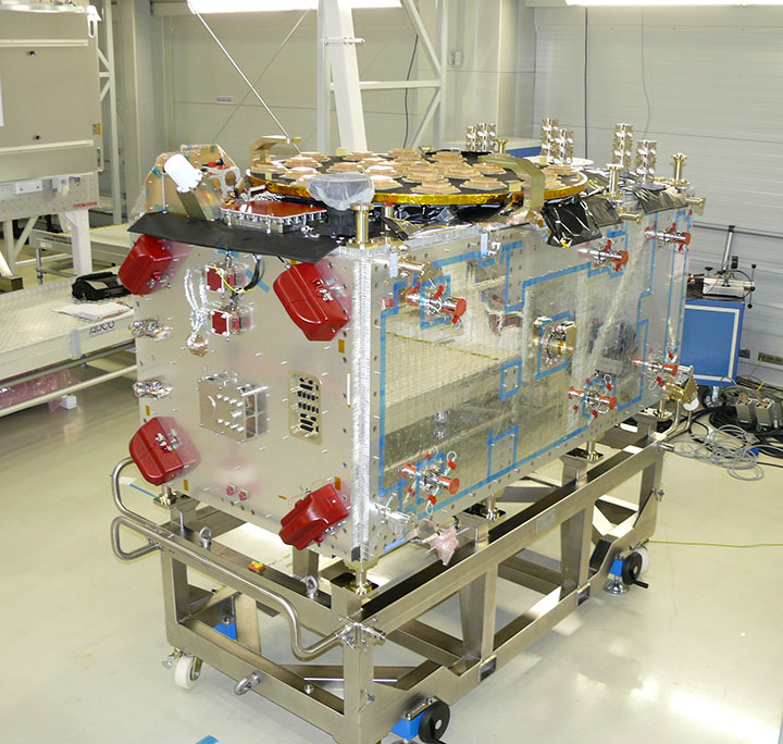
In the early hours of May 15, Galileo’s first full operational capability (FOC) satellite left the manufacturer’s integration hall in Bremen, Germany. The satellite, assembled by OHB System AG, is now headed for Noordwijk in the Netherlands, where it will undergo an environmental testing campaign and further system testing at the ESTEC’s Test Center on the premises of the European Space Agency (ESA).
Before the satellite was shipped, it had successfully completed integration and system testing, according to OHB System.
The first Galileo FOC satellite. (Photo credit: OHB System AG.)
Its twin FOC satellite is in the final phase of completion at OHB System. Over the next few weeks, it will also be integrated and tested, after which it will be shipped to Noordwijk. The two satellites are to be placed in orbit on board a Soyuz launcher, which will is planned to lift off from Kourou in French Guyana this fall.
These two satellites are the first of a series of 22 Galileo FOC satellites manufactured by OHB System and its industrial partners. The FOC phase of the Galileo program is managed and funded by the European Union. The European Commission and ESA have signed a delegation agreement by which ESA acts as design and procurement agent on behalf of the commission.
At ESA’s test center, thermal vacuum testing will simulate the temperature extremes the satellites must endure in the airlessness of space throughout their 12-year working lifetimes. Without any moderating atmosphere, temperatures can shift hundreds of degrees from sunlight to shadow.
Other activities on the schedule include shaker and acoustic noise testing — simulating the vibration and noise of launch — as well as electromagnetic compatibility and antenna testing, placing the satellite in chambers shielded from all external radio signals to reproduce infinite space and check that its various antennas and electrical systems are interoperable without harmful interference.
Each satellite will offer the full range of Galileo positioning, navigation and timing services, plus search and rescue message relays, their accuracy ensured by on-board atomic clocks kept synchronized by a worldwide ground network.
“The Galileo FOC satellites provide the same capabilities as the previous IOV satellites, but with improved performance, such as higher transmit power,” explained Giuliano Gatti, head of the Galileo Space Segment Procurement Office. “They are to all intents a new design that requires a full checkout before getting the green light for launch. By fully validating this satellite, the second flight model due to follow it here at beginning of June, and the third one due to arrive in ESTEC at middle of July, we gain full knowledge of their characteristics, and the further satellites in the series will require less rigorous functional testing.”


 After the separation of the two Galileo satellites