The European Commission plans to expand its drone wall on Europe’s eastern borders because some regions said they felt left out after an initial “wall”, reports Reuters. The idea is to counter drone incursions with a network of sensors, electronic jamming systems and weapons stretching from the Baltic states to the Black Sea.
The European Drone Defence Initiative proposal is included in the commission’s Defence Readiness Roadmap 2030 issued Oct. 16. Commission President Ursula von der Leyen proposed the drone wall after 20 Russian drones entered the airspace of EU and NATO member Poland in September.
Eastern European states welcomed her proposal, but countries in southern and western Europe said it neglected drone threats in their part of the continent.
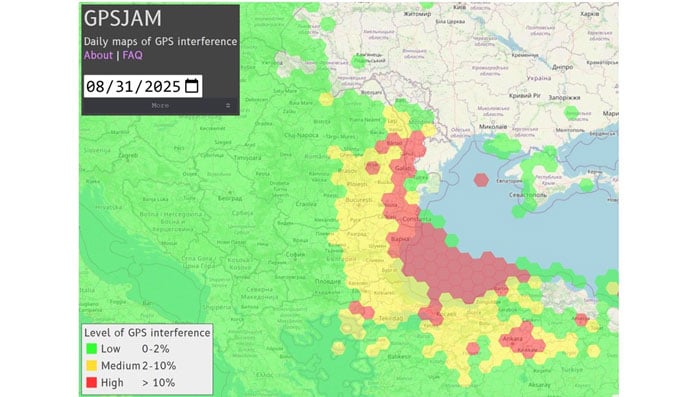
A plane carrying the European Commission President Ursula von der Leyen was targeted by GPS jamming while attempting to land at Plovdiv International Airport in Bulgaria on Aug. 31, according to a European Commission spokesperson.
Bulgarian authorities suspect Russia was responsible for the interference, European Commission Deputy Chief Spokesperson Arianna Podestà told CNN.
The Kremlin has denied the allegation. Spokesperson Dmitry Peskov told The Financial Times, which first reported the story, that the information was incorrect.
The plane landed safely despite the GPS disruption, with pilots reportedly using paper maps to navigate, according to a source familiar with the situation.
Von der Leyen was traveling as part of a seven-country tour of the European Union’s frontline states to rally support for Ukraine. The incident occurred as her charter flight approached the southern Bulgarian airport during her diplomatic mission to reinforce the bloc’s commitment to defending against Russian aggression.
Podestà told CNN that the incident highlighted the urgency of von der Leyen’s current trip to frontline member states, where she has witnessed daily threats from Russia and its proxies. The spokesperson noted it remained unclear whether attackers specifically targeted the flight or if it was caught in broader GPS interference operations.
Expert Insights:Searching for Resilience
This latest incident comes amid a dramatic surge in GPS jamming and spoofing attacks across the region since Russia’s invasion of Ukraine, creating an increasingly challenging environment for critical navigation systems.
European Commission President Ursula von der Leyen’s current tour through Poland, Bulgaria, Finland, Estonia, Lithuania, Latvia and Romania takes her directly through many of the continent’s GPS disruption hot spots. These nations have experienced some of the most severe interference with GNSS, making the timing of her defense-focused diplomatic mission particularly significant.
According to GPS World Editorial Advisory Board Member Mitch Narins, the current crisis represents the culmination of concerns that have been raised for more than twenty years. “Concerns and warnings regarding interference to GNSS have been raised for over two decades,” Narins explains. “Despite these concerns, attempts to install and upgrade alternative or complementary PNT systems on the ground and in aircraft have failed and resulted solely in increased investment in satellites and their signals, all of which are extremely low-power by design and vulnerable to interference.”
“Regrettably, the substantial financial resources required to fund these satellite projects have pushed for discontinuance of resilient ground-based alternatives and to consider them ‘cost offsets,’” he notes. The economic incentives have favored satellite constellation expansion over diversification, despite the vulnerabilities of space-based systems.
When it comes to alternative options, Narins explains, “For the cost of building and launching a single GNSS medium-Earth orbit (MEO) satellite, one could fund the replacement or installation and operation of many resilient ground-based systems for many years.”
The current approach to PNT systems represents a departure from fundamental systems engineering principles, according to Narins. “When initiating a customer need analysis, a systems engineer does not begin with the solution and work backwards,” he emphasizes.
Instead, the focus should be on meeting actual requirements: PNT systems must “always” provide the accuracy, availability, integrity and continuity of services necessary to support safety, security and economic well-being across thousands of use cases spanning every critical infrastructure sector.
“Therefore, resilience must be a critical part of a PNT system’s performance if it is to be considered a potential solution,” Narins said. Rather than pursuing interoperability between GNSS constellations — which still leaves users dependent on inherently weak satellite signals — the industry should have prioritized diverse solutions from the outset.
He added, “This is not a simple problem with a single, simple solution, but it is time to start thinking about resilience first and leaving the identification of solutions to a proper system engineering process.”
New Ways to Counter EW Threats
The dangerous GPS jamming of the plane carrying carrying European Commission President Ursula von der Leyen can be alleviated with advanced technology, according to Michael Biercuk, CEO of Q-CTRL, developers of quantum-based navigation systems:
“The incident regarding the European Commission President’s plane has raised GPS denial from inconvenience to a strategic security threat. This is why we’ve focused our quantum tech development efforts on building resilient quantum navigation systems truly immune to jamming and spoofing. This technology is not science fiction – it has been validated in flight to outperform the best existing GPS backups by up to 100X. Through our partnerships with Airbus, Lockheed Martin, and others we’re ready to help build resilience for European transport, defense and commerce.”
Chris Shaw, CEO and co-founder of Advanced Navigation also spoke on the incident, commenting “The answers to the GPS crisis are already here,” said Chris Shaw, CEO and co-founder of Advanced Navigation, which specializes in anti-electronic warfare navigation technology. “The problem isn’t innovation, it’s stagnation. GPS alone can no longer be treated as a reliable source of truth. What’s needed is a resilient architecture — inertial-centered and fused with multiple sensors — that keeps systems operating even when signals are denied or manipulated.
“The reality is that adversaries are moving at the speed of code, while government procurement still runs at the speed of bureaucracy. That gap is a national security risk. Unless governments adopt a new model of rapid integration and real-time collaboration with industry, they will continue to be outpaced.
“This isn’t optional. Survivability in GPS-contested environments depends on prompt deployment of inertial navigation. The companies pushing this forward aren’t just keeping up, they’re rewriting the playbook — and the cost of delay is measured in mission failure and compromised sovereignty.
“Ukraine has shown what’s possible. By demanding real-time software updates and rapid hardware upgrades in close collaboration with industry, its forces are reshaping autonomy, navigation, drone swarms and integrated defense systems at an unprecedented pace — allowing them to outpace adversaries.
“So why aren’t we applying this model more broadly beyond the battlefield? The solutions exist, with inertial navigation at the core. The real question is whether we’ll act before the cost of delay becomes irreversible.”
The GPS Collapse isn’t fiction — it’s a warning of what happens when action is delayed.
13 member states of the European Union have called on the European Commission to respond to interference with GNSS in EU countries.
The interference originates in Russia and Belarus, as a result of the ongoing war with Ukraine.
The ministers for transport from 13 countries urged immediate and coordinated action in response, reports the Baltic Times. The joint letter was signed by the ministers of Lithuania, Latvia, Estonia, Germany, Slovakia, Finland, Slovenia, the Czech Republic, Italy, the Netherlands, Spain, Denmark and Romania.
In the joint letter, the ministers emphasize that since 2022, two types of interference to GNSS — jamming and spoofing — have been observed in the airspace of the Baltic Sea Region, posing a threat to various modes of transport, particularly civil aviation and maritime navigation.
The General Secretariat of the Council of the EU responded to the joint letter with an outline of potential actions.
Evaluate and coordinate the possibility to suspend the right to Russia and Belarus in the ITU to register the use of radio resources while GNSS interference is in progress. The lack of procedural legislation cannot be an excuse for deliberately contravening the spirit of the ITU Constitution and its general principles, endangering public health and life, without suffering any consequences.
Based on good practice of EU and NATO cooperation on critical undersea infrastructure, enhance civil-military coordination mechanisms among Member States for shared monitoring, data exchange, and possible response to GNSS interference. Explore the benefits of dual use of various equipment and measures to combat the risks caused by GNSS interference.
Intensify RFI monitoring by eligible national organizations and bodies, e. g. national regulator, police and military, and aggregate non-classified information on observed RFI to a publicly available near real-time monitoring and alert service on European level.
Accelerate the deployment of interference resistant GNSS services, especially the antispoofing features that are part of the Galileo program, e. g. authentication and/or encryption of signals exchanged between stations and user equipment.
Reassess the current reliance on GNSS-based navigation and develop resilient Positioning, Navigation and Timing (PST) services by deploying alternative or complementary systems, including ground-based legacy solutions. Simultaneously, upgrade and modernize conventional navigation infrastructures to serve as robust backups.
Promote industry-manufacturer collaboration for mitigation tools and updates. Support operator-level reviews of backup system readiness, ensuring non-GNSS alternatives are usable and practiced. 2 TREE2B 9198/25 EN
Draw the attention of critical infrastructure operators and unmanned system manufacturers to the risks that may arise from interference with GNSS.
Develop action plans for different domains (space, aviation, maritime, telecommunications) to avoid potential duplication of efforts and coordinate short-term and long-term measures at EU and national level.
Continue cooperation with all relevant stakeholders (ITU, ICAO, IMO, EASA, EMSA, IATA, EUROCONTROL). These actions, among others, could contribute to building the overall resilience of the critical infrastructure and strengthening safety and security in Europe.
The letter highlights the urgent need to accelerate the deployment of interference-resistant GNSS services, enhance the overall resilience of critical infrastructure, and strengthen safety and security across Europe.
“The current security environment demands a unified response to hybrid threats posed by hostile regimes, as well as close cooperation to strengthen Europe’s preparedness and resilience,” said Lithuanian Transport and Communications Minister Eugenijus Sabutis.
“Disruptions to GNSS signals have a direct impact on strategic sectors such as transport, energy, and telecommunications. To prevent potential incidents, we must act swiftly and decisively at the European Union level — not individually, but in a coordinated manner,” Sabutis said.
The interference is not random incidents but a systematic, deliberate action by Russia and Belarus, which can be used as a hybrid attack on strategic radio spectrum, essential for modern technology, regional safety and security, particularly in transportation.
Furthermore, the ministers call on the EU to increase diplomatic efforts to address the interference and apply pressure on the responsible parties, including legal action against responsible individuals and entities involved in the deliberate interference with GNSS signals, to enhance European safety and security.
“So far, the attempts by several Member States to address the problem have not brought any more tangible results,” the EU General Secretariats said. “Therefore, it is necessary to increase diplomatic efforts to address the interference and put the pressure on the responsible parties.”
The ministers propose intensifying radio frequency monitoring and enhance civil-military coordination mechanisms among Member States for shared monitoring, data exchange and possible response to GNSS interference. They also advocate for accelerating the deployment of interference-resistant GNSS services, particularly the anti-spoofing features of the Galileo program, and for upgrading and modernizing conventional navigation infrastructure.
Reports of increased interference include:
Lithuania: starting from 556 cases in March 2024 to 890 in October 2024 and 1185 in January 2025
Latvia: 790 cases in October 2024 to 1288 cases in January 2025
Estonia: 1150 cases in October 2024 and 1085 cases in January 2025
Poland: 1908 cases in October 2024 to 2732 cases in January 2025.
The European Union Agency for the Space Programme (EUSPA) has completed the testing of the Galileo Open Service Navigation Message Authentication (OSNMA) and is now gearing up for its operational launch.
Galileo, similar to any other GNSS, is used by many critical applications in transportation, finance, telecommunications, information technology, energy, utilities, manufacturing, health services, emergency services and law enforcement.
However, the rise in spoofing attacks, which can disrupt these services, has prompted the development of OSNMA. This capability, integrated into the Galileo infrastructure by EUSPA, the European Commission (EC), and the European Space Agency (ESA), aims to enhance the security of GNSS signals.
The OSNMA Public Observation phase began in November 2021, supported by the release of the Signal in Space Interface Control Document (SIS ICD) and the Receiver Guidelines, which facilitated early testing of OSNMA receivers worldwide. Since then, users have reported that the OSNMA signal has been transmitted by Galileo satellites with high stability and performance.
In December 2022, EUSPA and the EC published the OSNMA SIS ICD and Receiver Guidelines for the service phase, with further updates released between October 2023 and January 2024. Additionally, the OSNMA Internet Data Distribution (IDD) ICD was published in July 2023 and updated in January 2024, alongside the operational cryptographic material. The OSNMA signal has been transmitted following these specifications since August 2023.
According to EUSPA, Testing activities by industry and public actors have confirmed the readiness of the service, with the latest cryptographic material published by EUSPA in January 2024. This material and necessary certificates are available through the EUSPA and GSC websites for the Initial Service provision phase.
The testing activities concluded in early June 2024 with the execution of cryptographic keychain renewal and revocation processes. The program is now preparing for the OSNMA Initial Service declaration, which will include an EC communication, the publication of the OSNMA Service Definition Document (SDD) and the transition of the OSNMA Status Flag from “test” to “operational” following a process similar to that used in 2023 for the Galileo High Accuracy Service (HAS) Declaration. According to EUSPA, a dedicated Galileo Service Notice will soon be published to announce the conclusion of the testing activities of the Public Observation Phase.
The Safran Navigation & Timing critical infrastructure solution, White Rabbit, has received high praise in a report published by the European Commission (EC) Joint Research Center (JRC) that evaluates the effectiveness of alternative positioning, navigation and timing (APNT) platforms.
For more than eight months, the commission studied a variety of available solutions to assess the performance of APNT demonstration platforms in a variety of situations where there is signal loss, and a backup system is necessary. The selected solutions were evaluated for precise and robust timing and positioning services in challenging indoor and outdoor environments.
Safran’s White Rabbit is a high-accuracy time and frequency distribution protocol, which combines precise time protocol (PTP) packets with the frequency base of Synchronous Ethernet (SyncE) to provide sub-nanosecond time transfer accuracy over an optical fiber. While the results of the test campaign showed that all APNT platforms under evaluation demonstrated performances in compliance with the requirements set, White Rabbit excelled in its performance.
Safran demonstrated White Rabbit’s ultra-accurate time transfer over fiber optics, its high-performance time generation, resiliency (based on failover and holdover), interoperability, and user-friendly monitoring capabilities.
As stated in the report, Safran demonstrated, “the ability to handle multiple master clock inputs with voting and seamless switchovers. Interconnecting as many NMIs as possible, with possible local atomic clock backups, would result in a very robust and resilient time architecture, independent from GNSS across Europe. The ability to provide resilient and accurate time through the EU communication infrastructure, ideally on the nanosecond level, would also enable robust positioning, using a combination of signals.”
Thales Alenia Space has signed a €43 million contract for the Euro High-Altitude Platform Systems (HAPS) demonstration project. EuroHAPS was selected by the European Commission on July 20, 2022, for collaborative defense research and development projects from the European Defense Fund.
EuroHAPS aims to develop several stratospheric demonstrators for missions designed to improve intelligence, surveillance and reconnaissance and communications capabilities. Project partners include companies from Italy, Spain, Germany and France.
The project will conduct flight demonstrations for three types of complementary stratospheric platforms: A reduced-scale Stratobus from Thales Alenia Space, a solar-powered airship designed for long-endurance missions and offering large payload capacity, Hybrid High Altitude Airship from the Italian Aerospace Research Centre capable of generating extra lift with a wing airfoil, and autonomous stratospheric balloon system from ESG and TAO consisting of a series of three altitude-controllable balloons.
These three types of platforms are complementary and feature different operating times, capacity and operational restrictions. They will give Europe a broad spectrum of solutions to meet a variety of different requirements.
The platforms will test a range of missions, including lidar observation to detect and classify targets at sea or on land and the ability to detect them in environments with vegetation cover. Communications intelligence and electronic intelligence missions will also be tested, as well as a meshed broadband communications network for air and land players.
HAPS offer a new opportunity to complement ground-based, satellite-based or airborne assets with unique capabilities tailored to operational requirements. These flight demonstrations of HAPS will enable demonstrations of different platforms and address the main technical risks associated with these new technologies while refining operational requirements to ultimately enable development of future HAPS systems.
One Galileo satellite has been reconfigured to emit a new signal component optimized to serve low-end receiver devices and internet of things (IoT) applications. According to the European Space Agency (ESA), GSAT0202, in elliptical orbit, was reconfigured in January to transmit the new signal, also known as the G1 E5 Quasi Pilot.
The G1 E5 Quasi Pilot in the E5 band lies along a narrow part of the overall Galileo signal, intended to enable streamlined positioning fixes requiring less calculation — without affecting the E1 and E6 signal bands, on which Galileo also transmits. The initial receiver test showed that the signal component has the potential to reduce the signal acquisition time by a factor of three compared to the current GPS L5 or Galileo E5a signals.
Image: ESA
Once GSAT0202 was reconfigured, signal measurements were collected using the high-gain antenna installations from the Galileo in-orbit test facility, which confirmed the stability of the augmented signal. After G1 E5 Quasi Pilot was broadcast, it was successfully acquired and tracked by a set of receivers.
Airbus Defense and Space, Thales Alenia Space Italy, the European Union Agency for the Space Programme (EUSPA), the European Commission, and Spaceopal supported this test.
The other elliptical Galileo satellite, GSAT0201, will also be reconfigured after further testing. Selected chipset manufacturers will be involved in the testing under supervision of EUSPA. The test results will be evaluated at the Galileo Programme level, to eventually introduce G1 E5 Quasi Pilot into the constellation.
In 2022, the Galileo GNSS continued to provide the world’s most precise satellite navigation information, to a user base that stands at more than 3.5 billion worldwide. Furthermore, provided services continue to improve and expand, with plans for high-accuracy positioning and signal authentication now reaching fruition.
The European Union Agency for the Space Programme (EUSPA) and the European Space Agency (ESA) continue to enjoy an effective collaboration on the many development, deployment, and evolution activities of the Galileo Programme — each according to their respective responsibilities for service provision and system development with the European Commission (EC) acting as the program manager.
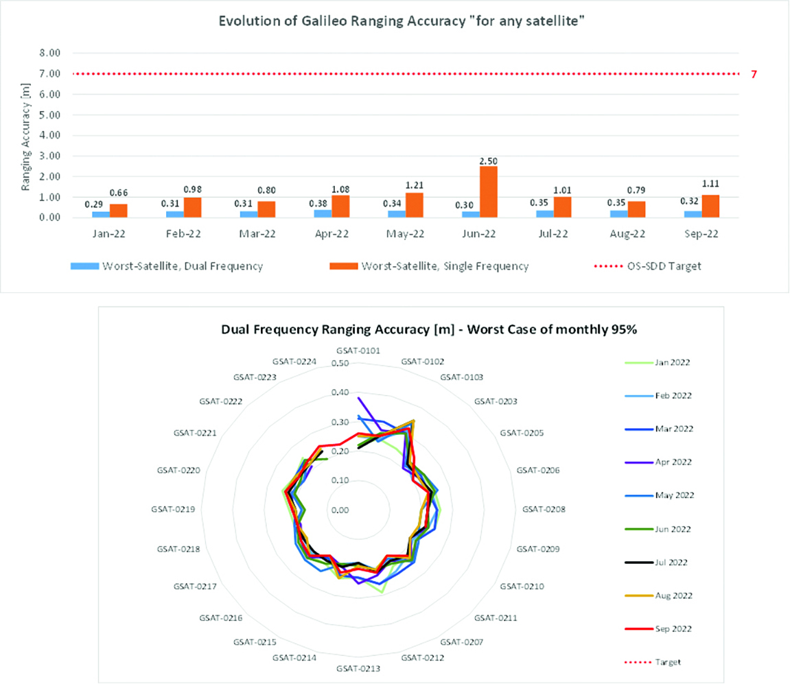
Ranging accuracy performance from January to September 2022.
Positioning-related MPLS from January to October 2022.
New Services Launched in 2022
Excellent Performance
Service delivery operations and maintenance of operational systems are managed by EUSPA, which supervises many contracts that carry out the day-to-day activities from dedicated control and monitoring centers throughout Europe. In 2022, Galileo timing, navigation, and SAR/Galileo services were delivered with excellent performances that continue to exceed the formal declarations for minimum performance levels (MPL), which were increased in January, both in terms of absolute accuracy and overall service availability. The entry into service of two additional satellites in May and August, have further consolidated the overall service availability to end users.
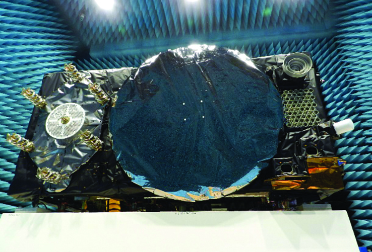
Galileo FOC Batch 3 satellite under testing.
Expansion of Service Portfolio
The service provision teams have been able to focus on improvements to, and expansion of, the service portfolio.
The I/NAV improvement will positively impact end users by enabling a faster time to first fix, and updates to the data validity status flags will lead to better protection of users against expired navigation data. These changes are implemented in updates of the onboard software of the satellites being rolled out across the constellation. At present, seven operational satellites have been successfully updated; the complete software upgrade campaign is planned to be completed this summer.
Galileo’s new High Accuracy Service will provide free precise point positioning (PPP) corrections, in the Galileo E6-B data component and by terrestrial means, for Galileo and GPS (single and multi-frequency) to achieve real-time user position improved by up to 10 times. The infrastructure to support an initial service (Phase 1) is nearing completion, and the formal declaration of the service capabilities is planned for early this year.
To provide users with a method of authenticating the received Galileo signals, especially the satellites ephemerides and the Galileo timing parameters, the new Open ServiceNavigation Message Authentication (OSNMA) service enables a receiver to confirm that a navigation message originated from the EU Galileo infrastructure. Many application areas are expected to benefit from this capability, including smart tachographs, telematics and logistics, UAVs, location-based services, and timing services. Having successfully demonstrated the technology behind the service in 2022, including a public observation phase, the roll-out of the Initial Service is planned to take place by the end of the year.
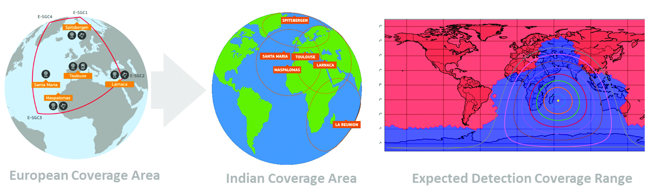
A fourth Medium Earth Orbit Local User Terminal (MEOLUT) in La Réunion will extend the SAR/Galileo Forward Link Service Coverage Area over the Indian Ocean as part of the SAR/Galileo full operational capability (FOC) declaration expected in the first quarter of 2023. The Cospas-Sarsat commissioning of this new station was completed in September 2022, and operational data is already being distributed to Cospas-Sarsat.
Reference documents for the above services can be found at the EUSPA European GNSS Service Centre website, including technical notes, interface control documents and service declaration documents.
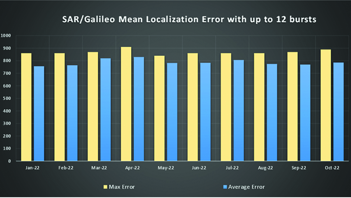
SAR/Galileo-related metrics from January to October 2022.
Extension of the SAR/Galileo Forward Link Service Coverage Area over the Indian Ocean.
FOC Infrastructure Development Nears Completion
Satellite Production
The production of the third batch of Galileo FOC satellites advanced further in 2022 with the completion of the environmental tests and the system compatibility test campaigns at the European Space Agency Test Centre in Noordwijk, The Netherlands. After 10 years of successful testing, on Oct.18, 2022, the last Galileo FOC satellite (flight model number 34) left the test center to return to the premises of the satellite manufacturer, OHB Systems, in Germany. Testing of the remaining 10 satellites has confirmed that they have been correctly built and will perform well in orbit. The acceptance review of the last couple of satellites will take place this summer.
At the beginning of 2023, the plan is to start in-orbit testing of a quasi-pilot signal on the E5 frequency using the Galileo GSAT201/202 satellites in elliptical orbit. The provision of a signal offering coarse acquisition in Galileo E5-A/GPS L5 can be a distinguishing feature for Galileo with respect to all other constellations to further improve the capability to acquire the E5 signal at low complexity. Following in-orbit testing, the strategy for roll-out of this capability will be assessed with the involvement of receiver manufacturers.
New SAR Galileo MEOLUT facility in Réunion island.
Access to Space
The discontinuation of Soyuz launch services from the Kourou Space Centre in French Guiana, because of the Russia-Ukraine conflict, has caused delays in the two Galileo launches that had been planned for 2022. The Launch 12 campaign had to be interrupted and in March 2022 the FM25 and 26 satellites were put in storage at the Kourou launch base, then returned to Europe in November.
Ariane 6 is the baseline launcher for Galileo satellites to ensure European independent access to space. The remaining Batch 3 satellites will be launched with the Ariane 62 launcher vehicle, the two strap-on solid booster variants of Ariane 6, now undergoing the final stages of development led by prime contractor Ariane Group. Ariane 6’s maiden flight is scheduled to take place in the fourth quarter of 2023.
Ground Segment
An upgrade of the ground control segment, in charge of command and control of the satellite constellation, is being developed by the industrial consortium led by GMV. The upgrades will address resolution of hardware and software obsolescence including cyber security, operability improvements, and a security monitoring overlay.
With the planned increase in the number of satellites in orbit, an additional telemetry tracking and control facility (TTCF) is being deployed in Kourou leading to seven operational TTCF stations in early 2023.
The ground mission segment, in charge of navigation control, is undergoing a complete technological refresh, including hardware/software virtualization performed by an industrial consortium led by Thales France. This upgrade will provide additional robustness, including a system extended contingency mode resilient to outages lasting up to seven days and a new state-of-the-art cyber security monitoring system. It will also provide ranging authentication through encrypted codes on the E6-C signal component for the implementation of the Commercial Authentication Service. Global coverage will be further increased with the introduction of two Galileo sensor stations in Wallis (Pacific Ocean) and Bonaire (Caribbean Sea), for a total of 15 sites around the globe.
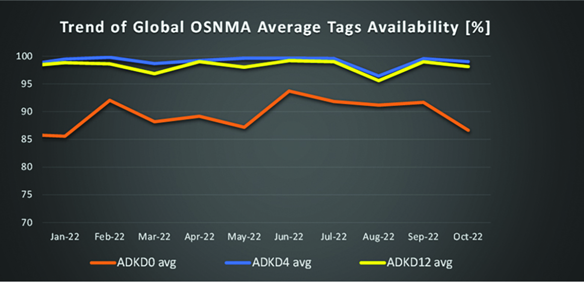
OSNMA-related metrics from January to October 2022.
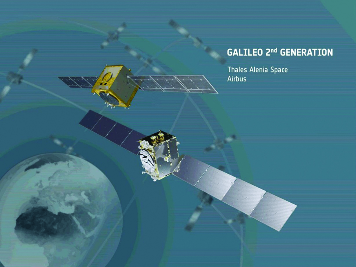
G2G Development Started
Galileo’s second generation (G2G) will introduce many innovative technologies to offer unprecedented precision, robustness, and flexibility.
2022 was a key year for the evolution of G2G activities with the fast development cycles of the first batch of G2 satellites, beginning development of the associated G2G in orbit validation (IOV) ground segment and system test beds, and the consolidation of the G2G final system capabilities — including the coordination of the mission/service roadmaps with the EC, EUSPA, and the EU Member States delegates.
Ariane 62 launcher.
G2G Satellite Manufacturing
From the satellite development point of view, the two parallel contracts to develop and manufacture each of the six G2G batch one (G2SB1) satellites are progressing in a fast development environment, with the first hardware units ready for integration and testing.
Following the completion of preliminary design review, these two contracts (for six satellites each) are preparing for unit-level validation/testing, which will lead to the critical design review.
These satellites will provide the following key innovations:
Reconfigurable fully digital navigation payload
Point-to-point connection between satellites by inter-satellite-link for command and control, and ranging functionalities
Electric propulsion for orbit-raising capabilities
Advanced jamming and spoofing protection mechanisms to safeguard.
The Galileo signals will improve with:
On-board authentication capabilities
Increased ground-to-space data rate
Improved time reference (number of clocks and advanced clock monitoring functions).
G2G IOV Procurements
2022 was also the year in which two key events took place with respect to G2G in-orbit validation (IOV) ground segment and system test bed procurements:
Finalization of the procurement cycle, now in the final evaluation/award phase, to be kicked off in the first quarter of this year
Confirmation of the IOV design through different coordinated actions with the EC and EUSPA, including the G2 system preliminary design review.
The contracts will provide Europe with the following capabilities:
G2SB1 satellite launch and early orbit phase, in-orbit testing and enhanced legacy services provision
G2 new capabilities in-orbit validation, including prototyping and validation of all the novel technologies that can exploit the full capabilities of the G2SB1 satellites.
Eleven contracts will be issued to manage in synchrony all the G1 and G2 assets for the coming years:
G2 IOV ground control segment (G2 GCS) for satellites monitoring and control
G2 IOV ground mission segment/secured facility (G2 GMS-GSF) for the production, dissemination and monitoring of all enhanced legacy services and the dissemination of new G2 advanced capabilities for validation
G2 IOV security monitoring (G2 SECMON), for the cyber/security monitoring of the system
G2 filling device (G2 FD), to ensure proper initialization of system assets
G2 system test bed (G2STB), to generate and monitor new G2 capabilities for validation of the G2G mission/services
G2 PRS test bed (G2PRSTB), similar to G2 system test bed but focused on advanced PRS capabilities for validation purposes
G2 security chain (G2SC), a test bed to ensure proper satellite-ground segment qualification before launch
Four system engineering support contracts (G2 SETA), where the main GNSS technical experts from different industries in Europe provide their support to ESA and EUSPA in their different fields of expertise.
These contracts are complemented by a significant set of system research and development and test tools, such as test user receivers and radio frequency constellation simulators.
G2G batch number one (G2SB1) satellites.
Galileo Second Generation System PDR
The Galileo Programme is not only focusing on short-term G2G development activities, but also looking forward to the future in terms of the consolidation and definition of G2G final operation capabilities. During the second half of 2022, more than 200 public representatives from the EC, EUSPA, ESA and Member States held countless meetings in the frame of the G2G system preliminary design review, which concluded in early December 2022.
As part of this review, the long-term implementation (G2G in orbit capability, or IOC, and final operational capability, or FOC) was reviewed and an agreement was reached on future steps. The evolution of Galileo capabilities will not only provide better services through advanced technical solutions, but will also ensure continuity of service and enhanced backward compatibility for first-generation legacy users.
Conclusions
The efforts of ESA and EUSPA continue with the aim of providing users continuous and stable services and evolving space and ground infrastructure to maintain Galileo competitiveness with the other global navigation satellite systems.
For analogous updates on the other three GNSS constellations, please see:
Galileo Second Generation Batch#1B satellites. (Image: ESA).
Technology multinational GMV has been awarded the NAVGUARD project by the European Commission.
NAVGUARD (Advanced Galileo PRS Resilience for EU Defence) will develop ground and space systems to detect illegal activities on GNSS frequencies and geolocate their sources. It also will build an information-management subsystem together with a user interface to provide a situational awareness picture.
The Galileo Public Regulated Service (PRS) is an encrypted navigation service for governmental authorized users and sensitive applications that require high continuity.
According to the EU Agency for the Space Programme (EUSPA), the PRS signal will ensure better continuity of service to authorized users when access to other navigation services may be degraded (resilience). In cases of malicious interference, PRS increases the likelihood of the continuous availability of the signal-in-space (robustness).
NAVGUARD is among various European Defence Fund (EDF) projects designed to sharpen the competitiveness of the European Union defense industry and strengthen the EU’s strategic autonomy. Besides navigation, the projects contracted to GMV will focus on developing missile defense system capabilities, systems for dismounted soldiers, avionics, command and control and cyber defense.
NextNav participated in the European Commission’s Joint Research Centre (JRC) alternative positioning, navigation and timing (APNT) evaluation in Ispra, Italy. At the trial, NextNav showcased an alternative PNT backup to GNSS, TerraPoiNT.
According to the JRC, the trial is analyzing the technologies “which could deliver positioning, and/or timing information, independently from GNSS, to be effective backup in the event of GNSS disruption, and if possible to be able to provide PNT in the environments where GNSS cannot be delivered.”
The test furthers the European Union’s creation of a backup to GNSS and is intended to assess which technologies could strengthen and expand the European PNT capacity.
PNT services are critical for the global economy, with studies estimating a contribution to the European GDP of approximately 10%. Today, GNSS services are the backbone of PNT, with an increasing role in new services and technologies, including car-sharing, autonomous vehicles, ship and aircraft navigation, smart logistics and precision agriculture.
It’s About Time
The timing capabilities of PNT are heavily utilized today by critical infrastructure, which is strategic from a commercial and societal perspective, including telecom, energy, finance and transportation. Published studies estimated economic losses of around 1 billion EUR per day if GNSS were unavailable.
NextNav’s TerraPoiNT trial focused on measuring the precision of timing delivery across alternate timing sources to better understand performance in GNSS-free environments — including instances of outages, spoofing and jamming. As a part of the trial, NextNav also demonstrated its capabilities in providing both indoor and outdoor z-axis vertical location.
TerraPoiNT is a system for assured PNT that uses terrestrial transmitters deployed around a service area to triangulate the location of a device. Unlike national space-based systems, the proximity of NextNav’s transmitters makes the signal strength 100,000 times that of GPS.
“The trials are part of the global trend to develop a resilience layer to space-based GPS/GNSS systems that is more secure and available,” said Ganesh Pattabiraman, NextNav CEO. “We are redefining the capabilities of APNT technologies and look forward to working with the European Commission on furthering these initiatives to build a GNSS backup layer that can deliver highly precise PNT across use-cases.”
Trials for U.S., Europe
The U.S. and countries across Europe continue to invest in both understanding and taking steps towards creating a resilient PNT layer in each nation. Participation in the JRC trial builds upon the recent evaluation of APNT technologies in the United States, including a 2021 U.S. Department of Transportation report, where TerraPoiNT was found to be the best performing APNT solution across use cases.
Further, NextNav recently created an APNT testbed in the San Francisco Bay area that was developed as part of a U.S. Department of Homeland Security demonstration used to evaluate the precision and resilience of NextNav’s TerraPoiNT network.
The JRC is expected to report results from the evaluation this spring.
Rohde & Schwarz adds an extension to its R&S TS-LBS location-based services test system to meet 112 emergency-call regulations for smartphones
E112 emergency caller location tests are now available on the R&S TS-LBS test system. (Photo: Rohde & Schwarz)
A new regulation requires all smartphones sold in the European Union from March 2022 onwards to support caller location for 112 emergency calls. To ensure this feature, the devices must be compliant with several positioning systems as outlined by the European Commission.
In response, Rohde & Schwarz has added an extension to its R&S TS-LBS location-based services test system. Certification service provider CETECOM has already started E112 testing using these test sequences.
All smartphones sold in the European Union have to be compliant as of March 17 with the Delegated Regulation (EU) 2019/320. A supplement to Radio Equipment Directive (RED) 2014/53/EU, it defines that 112 emergency calls provide caller location information to emergency services in a fast and accurate way, to make sure first responders can arrive at the site of an accident quickly.
Instead of a harmonized standard, a guideline document from the European Commission recommends the testing procedures for Notified Bodies, who support the smartphone vendors in the conformance assessment procedure. Compliance with Galileo, advanced mobile location (AML) and Wi-Fi positioning will be mandatory.
The software-based extension to the R&S TS-LBS location-based services test system makes it a tailored solution in line with the European Commission’s guideline document and the upcoming ETSI standard TS 103 825 for AML protocol testing.
In the Rohde & Schwarz solution, the cellular network is emulated by the R&S CMW500 wideband radio communication tester, while the dual-frequency E1+E5 GNSS Galileo signal is generated by an R&S SMBV100B vector signal generator. Thanks to the automation software of the test setup, all the test cases described in the EC guideline can be executed automatically to ensure unified, fast and repeatable results.
Thales Alenia Space, a joint venture between Thales (67%) and Leonardo (33%), has been selected by the European Commission for a new strategic contract to assess the feasibility of an integrity service to complement the European Global Navigation Satellite System (EGNSS) High Accuracy service, which will pave the way for use in autonomous vehicles.
Thales Alenia Space will focus on the development of a sensor-fusion approach, including and complementing evolutions of EGNSS High Accuracy. These service evolutions are aimed at providing the integrity level to serve the high-reliability and high-accuracy positioning needs of new, demanding applications such as autonomous vehicles on the road and autonomous transport in the maritime and rail sectors.
With this contract, Thales Alenia Space will assess the extension of the integrity and safety-of-life services for aviation into the road, rail and maritime sectors. In 2020, the company won the EPICURE project, based on an integrity concept for road travel (tolls and insurance), as well as the IMPRESS project, targeting an integrity service for rail signaling and train separation.
Thales Alenia Space has been a prime contractor for EGNOS (European Geostationary Navigation Overlay Service) for 25 years. It is a lead industrial contributor to the Galileo system and its ground mission segment and responsible for providing six Galileo Second Generation satellites. In April, the company was awarded a contract to support the implementation and experimentation of the navigation algorithms that will be used in the Galileo Second Generation program.