The European GNSS Agency (GSA) and the European Commission have concluded an agreement that delegates a range of exploitation tasks for Galileo to the GSA, providing a framework and budget for the development of services and operations through 2021.
The signing of the Galileo Exploitation Delegation Agreement serves as an initial step towards the full Galileo Exploitation Phase.
According to the governance structure set out in the Agreement for the Galileo programme, the European Commission is responsible for the overall programme supervision, the European Space Agency (ESA) is entrusted with the deployment phase, while the GSA is responsible for the exploitation phase.
As to the exploitation phase, the GSA’s responsibilities include:
Provision and marketing of the services
Management, maintenance, continuous improvement, evolution and protection of the space and ground infrastructure
Research and development of receiver platforms with innovative features in different application domains
Development of future generations of the system
Cooperation with other GNSS
All other required activities to ensure the development and smooth running of the system
“With Galileo, we aim to provide a tangible service to European citizens, and this Delegation Agreement ensures we have the tools and funding necessary to achieve this,” said GSA Executive Director Carlo des Dorides.
The Galileo exploitation phase will be progressively rolled out starting in 2014-2015, with full operability scheduled for 2020.
The agreement was signed between Daniel Calleja Crespo, director-general of the Enterprise and Industry Directorate-General at the European Commission and Carlo des Dorides, executive director of the GSA. The agreement specifically sets the actions to be implemented, the amount of funding provided, and the conditions for the overall management.
The implementation period of the agreement runs until 2021, with a comprehensive review of its functioning by the end of 2016. The maximum current EU contribution amounts to EUR 490 million, which will cover procurement and grant activities, including the GSA-ESA working arrangements and a programme management reserve, along with related research and development activities. The financing of the full exploitation phase will be confirmed during a mid-term review before the end of 2016.
In the presence of the European Commission, the European GNSS Agency (GSA) and EuroControl have signed a new cooperation agreement to jointly contribute to the implementation of European Union GNSS policies as they apply to the field of aviation.
As Europe’s skies and major airports become increasingly congested, there is need for Air Traffic Management (ATM) technologies to evolve from ground-based infrastructures to more advanced systems based on new technologies. EuroControl and the GSA have a shared objective in developing and exploiting European GNSS technology to improve accessibility, efficiency and safety to European operators, pilots and airports.
To accomplish this objective, the agreement focuses on a range of activities, including:
Definition of aviation user requirements for EGNOS and Galileo
Introduction of European GNSS services for aviation within the European Civil Aviation Conference (ECAC) area
Coordination in aviation research and development
Aviation-specific GNSS performance monitoring
Promotion of European GNSS aviation activities at the international level
“This is another example of European Commission support of the aviation sector,” said Daniel Calleja Crespo, director general of DG Enterprise and Industry at the European Commission. “I am confident that a strong cooperation between the GSA and EuroControl will benefit aviation, the European GNSS Programs and indeed European citizens.”
“The full deployment of GNSS offers unprecedented opportunities to further improve air traffic management safety and capacity, while reducing costs at pan-European level,” said GSA Executive Director Carlo des Dorides. “EuroControl’s activities in this field will complement those of the GSA to ensure that the development and implementation of satellite-based navigation provides an optimal solution for European airspace users.”
“EuroControl and the GSA share a common objective — the secure and safe implementation of European satellite navigation policies in the aviation sector. The enhanced cooperation between our two organizations means that EuroControl will now bring its unequaled capacity to understand, coordinate and represent the needs of the civil and military airspace users to the promotion and development of GNSS,” said Frank Brenner, director general of EuroControl.
EGNOS is Europe’s first venture into satellite navigation and has been providing a certified safety service for aviation users since 2010. EGNOS is owned by the European Union and, since January 1, 2014, the GSA is responsible for its exploitation, ensuring service provision, operations, maintenance and evolution.
The European GNSS Agency (GSA) has launched a call for proposals to foster further EGNOS adoption in the European civil aviation sector. The grant aims to support projects that enable users to equip and use their aircraft or rotorcraft fleet with GPS/SBAS-enabled avionics and allow Air Navigation Service Providers and aerodromes/heliports to implement EGNOS-based operations in Europe.
The purpose of the call is to co-fund projects capable of fostering EGNOS operational implementation for regional, business and general aviation and rotorcraft. In addition, commercial operators and original equipment manufacturers (OEMs) interested in benefiting from EGNOS may also apply.
Specifically, the call aims to:
Foster the design, development and operational implementation of EGNOS-based operations, including approach procedures at different European aerodromes and EGNOS based routes.
Develop and install GPS/EGNOS enabled avionics and granting of airworthiness certification for RNP APCH procedures down to LPV minima, including the development of Supplemental Type Certificates (STC) or Service Bulletins (SB).
Approve Air Operator Certificates for LPV operations of aircraft already equipped with SBAS capabilities.
Develop enablers to accelerate EGNOS adoption and preparation for its future capabilities, such as LPV 200.
The deadline for submitting applications is 16:00 CET, October 31.
Applications will be assessed in terms of relevance of the proposal and credibility of the proposed approach, economic and societal impact, and coherence and effectiveness of the work plan.
The total budget of the call is EUR 6,000,000 and maximum EU financing of eligible direct costs is 60 percent. In addition, a flat-rate amount of 7% of the total eligible direct costs of the action is eligible under indirect costs.
Awarding of the grants will happen in December 2014, with each grant agreement having an estimated duration of two years.
Galileo’s Early Proof of Concept (EPOC) team has successfully tracked the encrypted Galileo E6-B and E6-C signals broadcast by Galileo satellites. As a result, the Commercial Service loop has been closed using both encrypted and non-encrypted signals, GSA said.
During a 10-day testing period, receivers in Tres Cantos, Spain and Poing, Germany, showed the successful tracking and data demodulation of the encrypted signals from the available Galileo satellites, with periods where all satellites transmitting E6 encrypted signals were tracked simultaneously. The tests verified the Galileo Commercial Service (CS) signal’s encryption functionalities, with the data received containing authentication and high accuracy information previously generated outside the Galileo system. This is an essential feature to ensuring Galileo’s high accuracy and authentication services — some of which may be commercial in nature.
“The Commercial Service has the potential to improve the performance of existing location services for all user communities and therefore will be a key element of Galileo’s service provision,” said Carlo des Dorides, Executive Director of the GSA. “It will also help further enhance the Galileo’s economic added-value in the downstream markets.”
The Galileo Commercial Service will deliver a range of added-value features, including positioning accurate to decimeter level and an authentication element, both of which allow for the development of innovative applications for professional or commercial use. The Galileo CS demonstrator began its proof of concept earlier this year, with early service expected to start in 2016.
Once operational, the CS will provide access to two additional encrypted signals on the E6 band, delivering a higher data throughput rate and increased accuracy. CS addresses the authentication and high-precision market segments and will deliver innovative services with improved performance and greater added value than those obtained through the open service.
“Although there are still many steps before the delivery of an operational CS, these first tests prove what Galileo can do in the near future,” said Ignacio Fernández Hernández, European Commission Officer in charge of the Galileo Commercial Service design and management.
The tests are the result of a collective effort involving teams and projects of AALECS (Authentication and Accurate Location Experimentation with the Commercial Service), supported by the European Commission, the GSA, the European Space Agency (ESA) and the Galileo operator Spaceopal.
The AALECS project is building a platform to connect to the European GNSS Service Centre (GSC) and transmit real time CS data through the Galileo satellites. This platform will be operational by 2015 and will demonstrate the real performance of future high accuracy and authentication services of Galileo prior to early service availability.
The European Commission launched AALECS in January 2014, and it was awarded to a consortium led by GMV including CGI, Qascom, IFEN, Veripos and KU Leuven. As part of the AALECS project, GMV and IFEN developed an early proof-of-concept platform aimed at testing external data transmission through offline means. The project will last for approximately two and a half years.
“This first successful demonstration shows the potential of Galileo to provide a new generation of innovative and high performance satellite-based navigation services,” said Miguel Romay, director of GNSS at GMV. “We are pleased to be part of the team developing the CS demonstrator and contribute to proving the capabilities of Galileo.”
The European Business Aviation Association (EBAA) and the European GNSS Agency (GSA) have signed a Memorandum of Understanding to promote the wide use of EGNOS — precision-based navigation (PBN) — at regional airports in Europe, following discussions at the European Space Solutions Conference in Prague in June.
Maintaining all-weather access at secondary and tertiary airports is becoming more and more important for the air transport community with ever-increasing difficulties when it comes to access at major hubs, according to the EBAA. Business aviation is now in a position to optimize access at more of these regional airports which are often characterized by limited investment or technical innovation on the ground. By improving penetration of EGNOS, the entire air transport value chain will be enhanced, the EBAA said.
“The aviation community stands to benefit greatly from EGNOS because it means safe access to small- and medium-sized airports without the need for expensive ground equipment,” said Fabio Gamba, EBAA CEO. “Approach procedures have been published for around 100 airports, which is still a far cry from where we should be. A move towards this technology is well overdue, and this is evident if you compare Europe to the U.S. We are proud to have signed this MoU with GSA and together we are committed to having many more procedures published in the near future.”
“The business aviation segment is a pioneer in the use of EGNOS and most new business aircraft are already equipped. This means that operators can start using published LPV procedures immediately, without making any upgrades, just by obtaining the operational approval from the authority where the aircraft is registered,” said Carlo des Dorides, GSA executive director.
“EGNOS increases accessibility and enables safer approaches to underserved airports also in poor weather conditions,” said Gian Gherardo Calini, GSA head of market development. “We are committed to working with business operators to enable opening new routes that best serve their specific needs.”
Rockwell Collins’ flight management system (FMS) and GNSS receiver successfully enabled the first demonstrations of advanced arrival and departure flight operations for the European Union’s airspace-enhancing project FilGAPP (“Filling the Gap” in GNSS Advanced Procedures and Operations).
The goal of FilGAPP is to create new, more efficient methods of navigating airspace using satellite-based navigation and advanced FMS functions.
“FilGAPP highlights the opportunity that exists for air carriers and corporate operators to increase operating capacity and to save time and fuel through more efficient terminal procedures at European airports,” said Claude Alber, vice president and managing director, Europe, the Middle East and Africa (EuMEA) for Rockwell Collins.
The most recent demonstration, performed in Germany in collaboration with key FilGAPP operational partners, took place on a Hawker 750 aircraft equipped with Rockwell Collins’ FMS and GNSS receiver. It was the first time that a high precision and high integrity missed approach/departure was performed in Europe.
The flights also validated technical and operational independence from the closely spaced air traffic control systems of two nearby airports, which enabled increased operational capacity for each airport.
Similar advanced departure/arrival demonstrations as part of project FilGAPP were performed earlier in the year with Air Nostrum (Iberia Regional) in Spain on Bombardier CRJ-1000 aircraft equipped with Rockwell Collins systems. The trials took advantage of the radius-to-fix functionality connected to European Geostationary Navigation Overlay Service (EGNOS)-enabled localizer performance with vertical guidance (LPV) approaches.
FilGAPP is a project of the European Commission’s 7th Framework Program managed by the European GNSS Agency (GSA) and coordinated by the Spanish transport consultancy, INECO, with industry and national air navigation service provider partners, including Rockwell Collins.
The European GNSS Agency (GSA) is inviting European industries and Member State Competent Public Regulated Service (PRS) Authorities to share their views and ideas on which technologies at user segment level are important to support the adoption of the PRS. In particular, industries with potential interests and capabilities to support the development of Galileo PRS user segment technologies such as receivers, security modules, and dedicated infrastructure are encouraged to join the discussion.
PRS signals will be restricted to authorized users by governments for sensitive applications that require a high level of continuity. The PRS uses robust signals that are encrypted and resistant to jamming.
The GSA’s objective is to ensure that PRS service is affordable and secure for all interested users while also ensuring that European industry maintains its competitive edge in the global satellite navigation marketplace.
The GSA has already conducted several studies and projects aimed at identifying, developing and sustaining the necessary technology to support PRS market uptake. Additional initiatives are expected to be launched within the Horizon 2020 Framework Programme and in other programme initiatives in late 2014 and 2015.
Based on openly available information, the GSA has drafted a roadmap for developing and identifying the necessary secure technologies. This roadmap will be augmented by information gathered during the current consultations. It is expected that industry will provide additional inputs and ideas that may be
explored in the frame of Horizon 2020 and other initiatives. The GSA will use this information in planning long-term activities in support of PRS adoption, with a focus on technology preparation for a more effective market uptake.
Consultations will focus on the following topics:
Necessary steps for transforming the identified technologies into products competitive enough in terms of cost, power, dimension etc. to support the market uptake of PRS within the 2018-2020 timeframe.
Collection of information on the current European capability and capacity with the manufacturing sectors, with particular attention to nanotechnology manufacturing capabilities, and ideas of how to better use it for PRS market uptake.
Ideas of how to build, starting from the most promising technologies, the manufacturing lines capable of serving the PRS user segment need.
Main domains, elements and interfaces that will benefit from standardization, allowing for a stronger market adoption of PRS.
The deadline to receive requests is February 28. All consultations will be organized between February and April 2014. For more information and to arrange a one-on-one meeting, send an email to: [email protected].
Galileo PRS is restricted to governmental authorized users. It is intended for use with sensitive applications that require a high-level of service continuity. Authorized users include Member States, European Council, European Commission, EEAS, EU agencies and, subject to security agreements with the EU, third countries and international organizations.
Prague is now the headquarters of the European GNSS Agency (GSA).
A holiday card from a colleague in Europe calls to mind GNSS’s headlong course into the future, coupled with that most backward-reflective of human preoccupations, history.
The European GNSS Agency (GSA), whence originated this card, moved from Brussels to Prague in September 2012, in a nod to the pan-European nature of the European Union (EU) generally and its GNSSs, Galileo and EGNOS, in particular. No EU agency headquarters had been sited in Eastern Europe, and it was deemed that some soon must do. Prague made a strong bid for the GSA.
A political, cultural, and economic center of central Europe under its current name since the year 908, it has a settlement history dating back to 1306 BC. Good King Wenceslaus, who looked out upon the snow round about, deep and crisp and even, and about whom we sang festively this past season, ruled from Prague around 935, subsequently rose to sainthood, and is the patron saint of Bohemia, the Czech homeland.
The GSA has a rather variegated mission: it “manages public interests related to European GNSS programmes.” This includes everything from marketing to security — in a sense, everything satnav-related that scientists and engineers do not do. Its list of tasks and responsibilities includes 12 subheads and 61 bulleted points.
Carlo des Dorides, GSA executive director, noted upon opening the new headquarters in 2012 that Prague derives from the Slavic word praga, for threshold. “I think this is appropriate for the GSA and Galileo, as it represents the beginning of a key step for both.” EC vice-president Antonio Tajani added, “Galileo is important not only for space policy and science, but for the services and jobs that it brings.”
Thus the many GSA staffers labor to wring full advantage for modern economies from the space-based radio signal generators, amid the cobblestone streets and ancient monuments of one of the best-preserved ancient European cities, a UNESCO Cultural Heritage site.
While busily plunging into the future, we cannot escape our past.
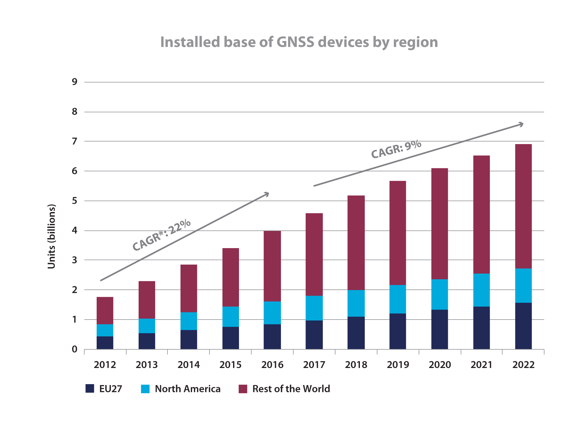
The tech press and broad public media have both made much ado about a November market report from the European GNSS Agency (GSA). Most accounts have focused on a GSA prediction of an installed base of 7 billion GNSS-enabled devices worldwide by 2022, and nearly every account has replicated the GSA math to trumpet “almost one for every person on the planet.”
Oh Hosanna. We (will) have reached holy ground at last.
Other than asserting that this bonanza “has the potential to deliver additional significant benefits, not measured in this report, especially in terms of time and fuel savings, as well as efficiency gains,” neither the GSA itself nor any pundit’s account of the report that I have seen ventures to speculate on how this might actually change daily human life. Hopefully ‘twill not be on the order of how cell phones have affected society, communication, and interaction; read tweeting and social-network stress. But knowing what little we do about human nature, this possibility is not at all to be discounted.
Allow me to walk the plank out into left field long enough to quote from a 2009 NBC News Science report titled “Is Twitter evil?” “Researchers probing the workings of the brain have found that it takes longer for feelings of social compassion and admiration to register on our neural circuits — and they worry that the rapid-fire effect of texting and tweeting could have ‘potentially negative consequences’ for our moral fiber.”
Could total, global, continuous, pervasive location-awareness in the palm of everyone’s hand possibly lead down a similar path? I’m sure that cell-phone enthusiasts also promised vast, billionish-plus benefits, with absolutely no downside, three decades ago.
If I can pry myself back from Nostradamus mutterings — and I am sure you are glad that I have now done so — the GNSS Market Report Issue 3 contains a great deal of data worth considering.
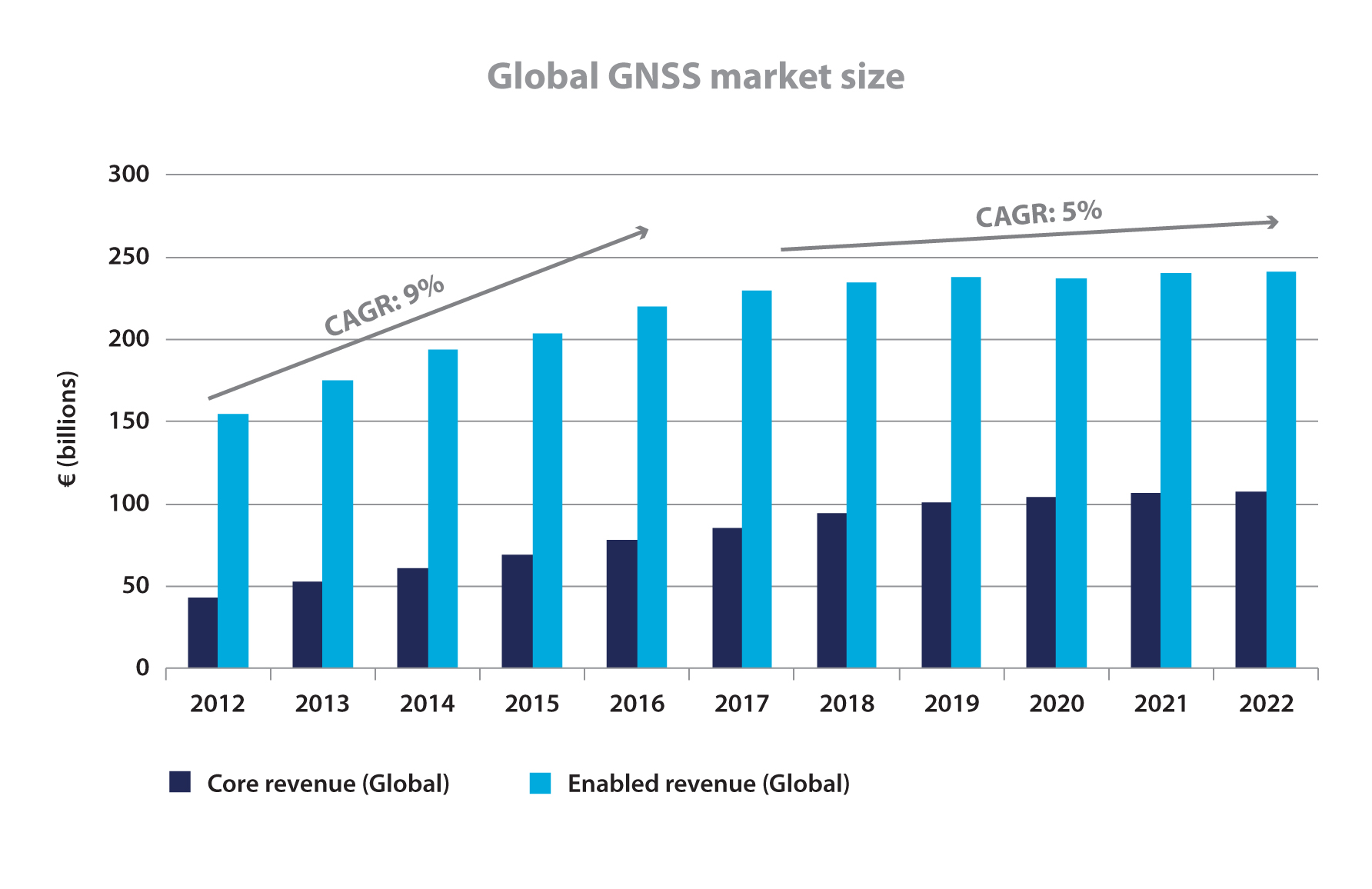
Said document foresees compound annual growth rates (CAGRs) for “GNSS core” and “GNSS-enabled” revenues increasing by 9 percent through 2016 and 5 percent through 2020, to attain €350 billion ($478 billion) per year. Of the 2022 total, GNSS core revenues will comprise about €100 billion (US$137 billion).
To further differentiate “core” and “enabled,” this from the report’s early Market Definitions section:
“This market report primarily considers the core GNSS market. For multi-function devices, such as smartphones, the core market includes the value of GNSS functionality only (rather than the full device price) and service revenues directly attributable to GNSS functionality (e.g. data downloaded by smartphones to use Location-Based Services).
“For multi-function devices, a correction factor is taken into account, for example:
• GNSS-enabled smartphone: only the value of GNSS chipsets is counted, estimated at 1% of the price.
• Personal Navigation Devices (PNDs): 100% of retail value since GNSS is the key enabler.
• Aviation: the value of the GNSS receiver inside the Flight Management System is taken into account.
• Precision agriculture system: the retail value of the GNSS receivers, maps, and navigation software is counted.
“The Executive Summary also presents results for the enabled market. The enabled market represents the services and devices enabled by GNSS, and includes the core market. For the enabled market, the entire retail value of the smartphone is included.”
The 72-page report breaks out market segments, focusing in turn on: location-based services (LBS), road, aviation, rail, maritime, agriculture, and surveying. The weight of the report, as you might guess by the necessity of reaching that 7 billion figure, falls primarily on LBS, a heading that for the GSA encompasses “smartphones, tablets, digital cameras, laptops, fitness and people-tracking devices, and mobile-data revenues.”
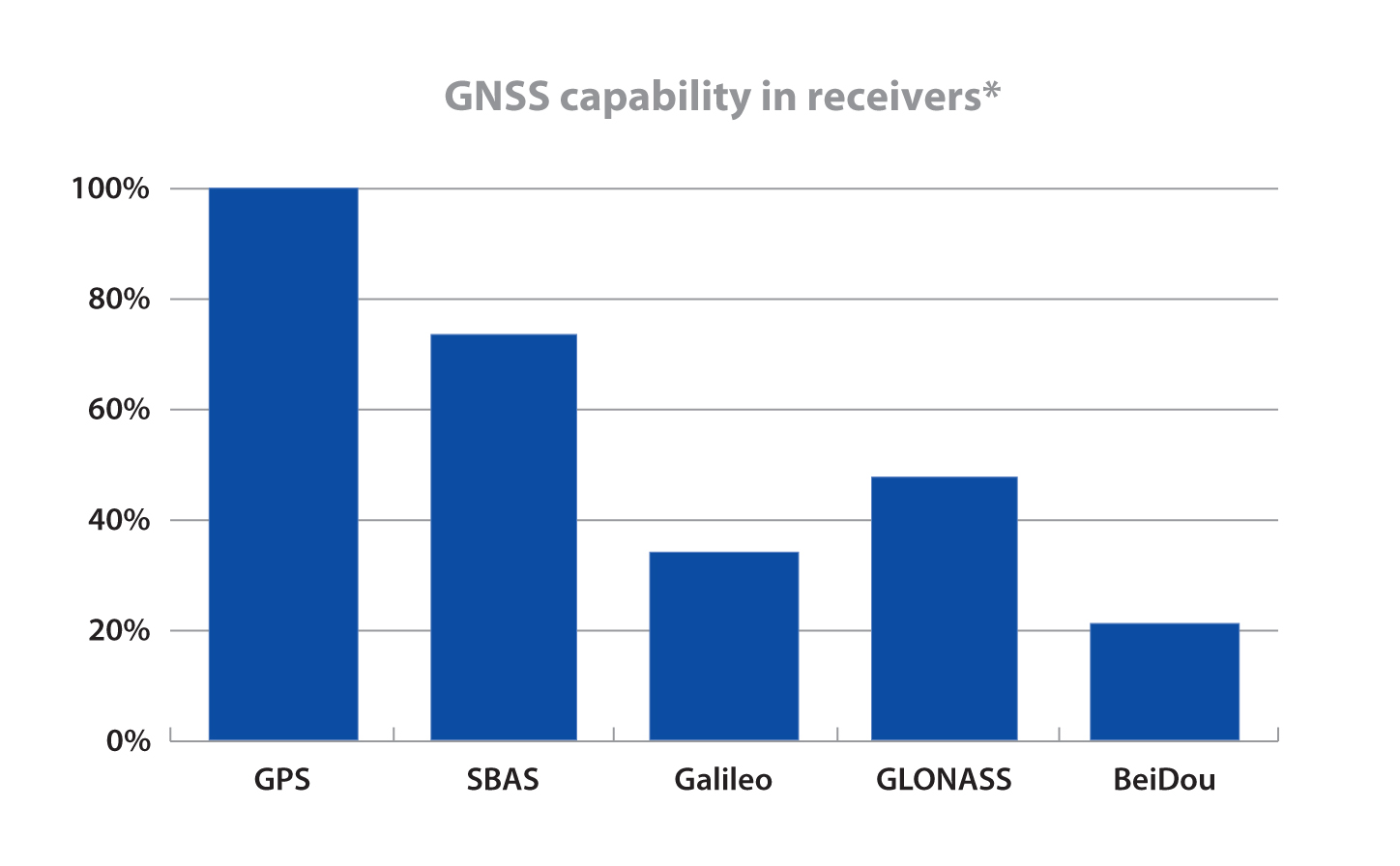
What’s good for the mass market must surely be good for satellite makers and operators around the world, as they attempt the jump from one to many systems. That’s the underlying but unstated premise of the report. “Multi-constellation receivers become widely available on the market” trumpets the Executive Summary headline on page 8. In what is certainly the money pitch for the Prague-based, European Union-funded agency, “Galileo is recognised as a valuable element in multi-constellation systems, and it is already present in more than 30% of receiver models, well ahead of its full operational capability.”
Nevertheless, GLONASS is the second GNSS constellation choice of receiver manufacturers after GPS.
For BeiDou, the researchers will only venture that “Several equipment manufacturers, particularly those based in Asia-Pacific, have started to offer BeiDou-enabled models.”
More than 70 percent of models on the market are GPS-SBAS capable (SBAS comprising WAAS, EGNOS, and MSAS) and this penetration will grow further.
In a final provocative note (neither final nor provocative from the GSA’s point of view, although I confess it causes me a vague unease), the four-fold increase in the number of GNSS devices will be “largely driven by increased penetration in regions outside Europe and North America.”
Production of the report relied on “advanced forecasting techniques together with a validation process with market experts.”
Lest you feel unfairly treated by my curmudgeonly take, here is some actual data generated by and taken from the report.
Global GNSS Market Size, from GNSS Market Report 2013 Issue 3Installed Base of GNSS Devices by Region, from GNSS Market Report 2013 Issue 3GNSS capability in receivers, from GNSS Market Report 2013 Issue 3
On August 30, QinetiQ and Rockwell Collins demonstrated the first joint satellite navigation positioning using live signals from the encrypted governmental services from the U.S. Department of Defense (DOD) GPS Precise Positioning Service (GPS-PPS) and the new European Galileo Public Regulated Service (PRS). The signals on GPS L1 and L2, together with Galileo PRS L1A and E6A, were processed and combined to form multi-frequency, multi-constellation position fixes.
Positioning, navigation and timing (PNT) services provided by GNSS, such as GPS and the forthcoming Galileo system, are essential to underpinning both commercial and economic activity (the EC estimates 6-7% of the developed world’s GDP) and the delivery of governmental responsibilities including the safety and security of citizens.
GNSS systems such as GPS and Galileo make use of very low power signals and are subject to inadvertent interference, deliberate jamming and spoofing (where an attacker generates a false signal masquerading as a valid one to mislead a user receiver). Attacks on GNSS may range from low-level criminal nuisance (a delivery driver stopping their employer tracking them), enabling theft of high-value vehicles fitted with trackers, through to state-sponsored attacks. This is potentially a significant concern for a wide range of governmental users including law enforcement, security and emergency services, critical national infrastructure, transport and defense users. The use of multiple independent, secured navigation services provides significant improvements to navigation robustness and, along with other measures, offers substantial counters to these threats.
“This has been our first opportunity to explore how secured navigation services on GPS and Galileo can be used together to provide users with critical reliance on PNT with robust and continuous navigation services,” Nigel Davies, Head of QinetiQ’s Secured Navigation Group said. “QinetiQ is proud to be a key, long-term contributor to the Galileo Programme, having been working closely with the European Space Agency (ESA), the European GNSS Agency (GSA), European industrial partners and European Member States since 2003. QinetiQ and Rockwell Collins wish to thank ESA, the EC and GSA for support in accessing Galileo, as well as the UK Space Agency, UK Satellite Applications Catapult and the UK MOD for their support.”
The European GNSS Agency (GSA) has published its second Global Satellite Navigation System (GNSS) Market Report, providing key information to entrepreneurs in the satellite navigation sector.
GNSS market forecasting is of great interest to private and public GNSS stakeholders, for business and strategic planning and policymaking, according to the GSA. According to the 2012 GSA Market Monitoring Report, the worldwide GNSS market is growing fast and the total market size is expected to increase at an average of 13 percent per year until 2016.
The total enabled GNSS market size is expected to stabilise in the latter half of the decade due to market saturation, price erosion and platform convergence. Global shipments of GNSS devices are lower than previously forecasted up until 2015 yet are forecasted to continue growing to over 1.1 billion units per year.
Expanding coverage. Following up on the first GNSS Market Report published in 2010, the GSA’s 2012 Report includes an analysis of two new sectors: maritime and surveying. Relevant examples from EU research projects have also been included for each sector.
2012 Report Highlights
Road and location-based services (LBS) still in the lead. Road and LBS dominate GNSS device sales (54% and 44% respectively). LBS constitutes 87% of the total GNSS market in terms of units sold and GNSS penetration in smartphones is set to increase from 30% today to almost 100% in 2020. For road navigation, traditional Personal Navigation Devices (PNDs) will gradually disappear from the European market yet remain present in other regions in the form of low cost OEM products. Smartphones and in-vehicle devices will be the preferred means of navigation.
Commercial aviation use will grow. In the Aviation sector, the segment that will see the greatest growth in terms of GNSS equipment revenues will be Commercial Aviation, surpassing general and business aviation by 2018.
GNSS use in agriculture continues to rise. In agriculture the current positive growth trend will continue; low cost precision agriculture solutions based on EGNOS are driving GNSS adoption by farmers in Europe.
Surveying: a growing opportunity. In surveying, the construction segment is dominating the market in terms of units and value. North America is leading in terms of market penetration but the other regions will catch up by 2020 as GNSS is rapidly replacing the traditional surveying and mapping methods in Europe and around the world.
Safer seas with GNSS. In the open sea segment, shipments of search-and-rescue (SAR) beacons will exceed those of other categories making the SAR segment the largest in terms of shipments and second largest in terms of market size.
The European GNSS Agency (GSA) has published a 2010 GNSS Market Monitoring report, providing key information in support of entrepreneurship in the satellite navigation sector.
GNSS market forecasting is of great interest to private and public GNSS stakeholders, for business and strategic planning and policymaking, said the GSA. According to the new report, the market for GNSS will grow significantly over the next decade, at a compound annual growth rate (CAGR) of 11 percent, reaching €165 billion for the core GNSS market in 2020. Delivery of GNSS devices will exceed one billion per year by 2020.
“This Report confirms that the market potential of GNSS is significant,” said Gian Gherardo Calini, head of the GSA Market Development Department. “The information should be useful to researchers, market players and decision makers who want to grasp the GNSS market opportunities today and tomorrow.”
Report Highlights
Road leads the way: The report shows that the road transport sector is still the leading GNSS segment, accounting for more than 50% of market share. The penetration of receivers in road vehicles, today at 30%, will exceed 80% over the next decade. However, after a period of fast growth, market saturation and competition in the form of ‘smartphones’, often equipped with free navigation capabilities, have resulted in a slowdown in the car-based navigation market.
Price erosion has been high, driven by declining costs and strong competition. Vendors are using innovation as a differentiator resulting in ‘converged’ products with both communication and multimedia functionalities. Some Personal Navigation Device (PND) vendors are also tapping into new distribution channels, including car dealerships and smartphone application stores.
GNSS for road transport: The road transport sector is facing major challenges, such as the demand for increasing safety and for reduced congestion and pollution. These problems are particularly acute in highly populated zones, including big cities and suburban areas. GNSS represents a powerful tool for improving road transport. Not only does it help get drivers where they want to go more quickly and efficiently, but it also promises fairer road-pricing schemes, for example, to automatically charge drivers for the use of road infrastructure.
GNSS in your hands. Mobile location-based services (LBS) are taking off as progress is being made in different areas. More and more mobile phones now have GNSS capabilities, the result of both increasing consumer and developer awareness and an improvement in navigation services and performance.
All major mobile phone operating system vendors now provide application programming interfaces (API) with location functions. In 2009, in the UK, France and Germany, 5 out of the 10 best-selling iPhone applications were related to navigation or location-based applications. Also, 30% of Android developers’ contest winners used location capabilities in their applications.
A promising future for location-based services. The integration of accurate hand-held positioning signal receivers, within mobile telephones, personal digital assistants (PDAs), mp3 players, portable computers, even digital cameras and video devices, brings GNSS services directly to individuals, making possible a fundamental transformation of the way we work and play. The penetration of GNSS in mobile phones is therefore expected to increase very quickly, from some 20% today to above 50% within the next five years.
The GSA says Galileo in the future and EGNOS today open up new and exciting prospects for economic growth, benefiting citizens, businesses and governments throughout the EU and beyond.
Just the beginning. The GSA underlines that the GNSS Market Monitoring process is ongoing and future reports are planned to update information presented in this first report and to cover other sectors. The Agency welcomes stakeholder contributions.