Tag: European GNSS Agency

  • A Scintillating Project

    A Scintillating Project

    FIGURE 2. TEC map over São Paulo state as forecast by the CALIBRA model on Sept. 26, 2012, at 2:00 UT. The range of the TEC in the image is from 0 to 90 TEC units (blue to red). The red line is the geomagnetic equator.
    FIGURE 2. TEC map over São Paulo state as forecast by the CALIBRA model on Sept. 26, 2012,
    at 2:00 UT. The range of the TEC in the image is from 0 to 90 TEC units (blue to red). The red
    line is the geomagnetic equator.

    Countering Ionospheric Disturbances Affecting GNSS in Brazil

    By Marcio Aquino

    After 27 months of intense research, the CALIBRA project ended successfully in February 2015, with the project team devising solutions to tackle the effects of perturbations typical of the Brazilian ionosphere on high-accuracy GNSS positioning. CALIBRA was funded by the European Union and the European GNSS Agency.

    Kicked off in 2012, CALIBRA first confirmed the vulnerability of GNSS high-accuracy techniques to ionospheric disturbances through a thorough user performance review, where degradation in GNSS Precise Point Positioning (PPP) and real-time kinematic (RTK) positioning was seen to correlate with the occurrence of ionospheric scintillation and high Total Electron Content (TEC) variability. This is especially so in Brazil, because of its geographical location extending across the magnetic equator in one of the most troublesome ionospheric regions of the Earth, qualifying the country as a test-bed for worst-case scenarios.

    The team established a suitable metric to characterize these disturbances, which was used in developing the new models and algorithms to counter their effects. The short-term empirical CALIBRA Forecasting Model (CFM) for TEC and scintillation was developed and tested.

    To counter scintillation, a number of approaches were proposed and their benefits demonstrated. Building on the project’s success, CALIBRA partner INGV (Istituto Nazionale di Geofisica e Vulcanologia) filed a patent for the CFM and a new spin-off company — SpacEarth Technology — was set up. SpacEarth aims to secure the software’s commercialization for potential applications and services, while also improving and adapting it to evolving market needs.

    Another outcome of commercial interest is that project partner Septentrio developed several rover-level mitigation approaches, notably a new model for ionospheric delay estimation.

    Monitoring Network. To support the research and operational activities of the project, a dedicated network of ionospheric scintillation monitor receivers (ISMRs) was deployed, forming the CIGALA-CALIBRA network of 12 monitoring stations equipped with PolaRxS receivers. A web interface for data analysis — the ISMR Query Tool  — was developed by project partner UNESP (São Paulo State University) and is available for public use, collecting and treating more than 10 million observations of GPS, GLONASS, Galileo, BeiDou and other augmentation systems on a daily basis. Data visualization and data mining techniques support users in data analysis and knowledge extraction.

    Finally, two important field trials aiming to validate the new algorithms were carried out in Brazil, involving actual precision agriculture and offshore operations. For the precision agriculture trial, the Brazilian company Agro Pastoril Campanelli provided expert operational environment and support.

     The tractor used in the precision agriculture trial at Agro Pastoril Campanelli’s premises.
    The tractor used in the precision agriculture trial at Agro Pastoril Campanelli’s premises.

    For the offshore trial, the project counted on the collaboration of the DOF Brasil Group representing Norskan Offshore, a provider of high-end offshore services to the Brazilian oil and gas industry. Detailed results of both trials are in the project’s final report, which can be accessed through the GSA.

    The Geograph vessel is operated by DOF Brasil.
    The Geograph vessel is operated by DOF Brasil.
    Setting up the receiver antenna for the offshore trial on board the Geograph vessel.
    Setting up the receiver antenna for the offshore trial on board the Geograph vessel.

    To provide a glimpse of the performance of the CALIBRA algorithms during the offshore trial, in FIGURE 1 we selected a period when strong scintillation conditions were encountered. In the top plot, two height component time series for kinematic PPP processing are shown, respectively, for the case where no mitigation is applied (black time series) and the case where the CALIBRA algorithm is applied (red time series).

    FIGURE 1. Performance of CALIBRA algorithms in the offshore trial.
    FIGURE 1. Performance of CALIBRA algorithms in the offshore trial.

    The bottom plot shows the level of amplitude scintillation (S4 index) affecting the GPS satellites over a 10-degree elevation angle.

    The improvement obtained with the CALIBRA solution can be seen in particular during the PPP convergence period (18:00 to 18:30 UT) and during the period of strong scintillation (22:30 to 23:30 UT). As there was no accurate ground truth available, the RMS values with respect to the mean height, taken from the quiet period (between 19:00 and 22:00 UTC), along with the percentage of improvement when applying the CALIBRA mitigation approach are summarized in TABLE 1.

    TABLE 1. RMS values with respect to mean height, 19:00–22:00 UTC.
    TABLE 1. RMS values with respect to mean height, 19:00–22:00 UTC.

    Despite all the successful work carried out by CALIBRA, the team notes that research must be continued to accomplish further improvement in models and algorithms to finally develop processes for real-time operation. The challenge would be to counter these ionospheric threats in the scope of an operational service aimed to provide robust high-accuracy positioning to support user applications.

    Furthermore, there were strong indications that the addition of Galileo will assist in mitigating the problems addressed in the project when more signals are available in space.


    Marcio Aquino is a Principal Research Fellow at the Nottingham Geospatial Institute of Nottingham University and leader of CALIBRA.

  • GSA Flight Event Celebrated, Demonstrated EGNOS

    GSA Flight Event Celebrated, Demonstrated EGNOS

    GSA-EGNOS-flight-event-O
    Screenshot from GSA video. See full GSA Flight Event 2015 video below.

    News from the European GNSS Agency

    Since its certification for civil aviation in 2011, EGNOS — the European satellite-based augmentation system — has been making flights in Europe safer, greener and more efficient. To celebrate this achievement and further promote EGNOS, the European GNSS Agency (GSA) in collaboration with the European Commission, invited the media and European aviation stakeholders for a unique EGNOS Flight Event in Toulouse, France, May 6-7.

    Today, more than 140 airports in 15 countries across Europe benefit from EGNOS — with many more preparing for implementation. 171 LPV (localizer performance with vertical guidance) and 86 BARO approaches are already certified for use.

    To highlight this impact, the EGNOS Flight Event, organized in collaboration with the European Commission, ESSP, ATR and Airbus, brought together aviation media and other sector stakeholders for a comprehensive briefing and demonstration of EGNOS, how it works and its significant benefits for the aviation sector. Along with flight demonstrations, the event assembled a unique array of EGNOS-experienced players — from pilots to operators, service providers and air traffic managers – to discuss how EGNOS is reshaping the future of air transportation in Europe.

    Across-the-Board Benefits

    Commercial, business and general aviation are all key market segments for EGNOS. For example, business and general aviation operators need to get to meetings as quickly and efficiently as possible, often requiring landing at smaller airports where Instrument Landing System (ILS) or other expensive ground-based navigation aids are simply not feasible. Thus, the implementation of EGNOS-based procedures at these airports significantly improves accessibility. “EGNOS, Europe’s first satellite navigation system, already has a good success story to tell,” says GSA Executive Director Carlo des Dorides. “EGNOS delivers continuous integrity protection in compliance with ICAO standards, allowing Cat I approaches with over 99 % availability. Today, 142 airports across Europe are benefitting from EGNOS — and the number is growing steadily.”

    According to GSA Head of Market Development Gian Gherardo Calini, the Agency has the capacity to support airports and operators wanting to benefit from EGNOS. For example, this year the Agency has allotted €6 million to co-fund projects to implement EGNOS in aviation. A similar amount had also been allocated in 2014.

    Airborne with EGNOS

    Demonstrations of EGNOS included a briefing on EGNOS for rotorcraft and with the presentation of the GARDEN project. The project is using EGNOS to enable increased safety and better access for helicopters, for example, enabling air ambulances to access city centre hospitals. Participants were also given a first-hand look at EGNOS implementation in the cockpit of an Airbus H175 rotorcraft.

    EGNOS in action was demonstrated by a series of flights using EGNOS for landing procedures with an ATR 42-600 turboprop, which was equipped with additional avionics in the main cabin so invited media could witness the technology at work. The flight demonstration took off from the Blagnac Airport in Toulouse, the venue for the EGNOS event, for a 15 minute circuit around Toulouse beforedemonstrating an EGNOS LPV approach and landing.

    EGNOS for A350

    A highlight on the tarmac was the Airbus A350WXB. Participants were given a tour of this new, state-of-the-art wide-bodied airliner — including a simulation of an EGNOS-enabled LPV landing in the cockpit. Airbus test pilot Jean-Christophe Lair described the A350’s new Satellite-based Landing System (SLS) that works with Satellite Based Augmentation Systems (SBAS) such as EGNOS. This is the first time such a system has been installed on a wide body airliner and will be supplied as a standard feature to customers.

    According to Lair, EGNOS is fully integrated into a common, harmonised landing system interface on the A350 – the SLS. This allows the pilot to fly precision approaches like an ILS with geometrical vertical guidance down to 200 feet. This new navigation system will provide Airbus operators a wider range of solutions to optimise operations and increase accessibility without any compromise to safety.

    EGNOS Expansion

    The potential for expansion of EGNOS/SBAS is huge both in terms of global coverage and potential for use in Europe.

    GSA Head of EGNOS Exploitation, Jean-Marc Piéplu, outlined the future upgrade of the system from the current Version 2 to EGNOS Version 3. “Version three will feature new capabilities, including dual frequency and dual-constellation with both GPS and Galileo,” he said.

    This extension could potentially widen EGNOS/SBAS global coverage for aviation to over 90%. When asked about the timescale for this extension of coverage, Piéplu indicated that if the political will was there to implement, then this could be accomplished in 10 years as there were no outstanding technical issues.

    According to International Council of Aircraft Owner and Pilot Association (IAOPA) Senior Vice President Martin Robinson, there is a huge potential for growth in Europe. Currently there are 4,649 aerodromes in Europe and some 50,000 general aviation aircraft operating. Compared to the US, only a fraction of these are SBAS enabled. In the US, the larger uptake of WAAS is due to a deliberate government-led industrial policy.

    “Europe still lags behind the United States and there’s definitely room for growth,” said Robinson. “EGNOS will help to provide greater access to aerodromes throughout Europe and improve safety — but we need to be quicker if we are to realize these benefits sooner.”

  • European GNSS R&D: There’s an App for That!

    European GNSS R&D: There’s an App for That!

    Cover: European GNSS AgencyA free app for both iOS and Android features the results of European GNSS Agency (GSA) supported research and development initiatives. The new EGNSS Research and Development (R&D) application highlights the tangible results coming out of the 7th Framework Programme (FP7) and is designed to serve as inspiration for those participating in the Horizon 2020 (H2020) period.

    The FP7 and H2020 programs, supported by the GSA, aim to support the development of EGNSS applications in key market segments. Both are geared towards accelerating the development of a European market for satellite navigation applications and creating new opportunities for European industry.

    “The app is an excellent opportunity for the GNSS community to take stock in the lessons learned during the FP7 funding period and set our sights on future R&D initiatives,” said GSA Executive Director Carlo des Dorides. “The application’s segment-specific search feature responds to the varied needs of our users, providing them with easily accessible and relevant information at their fingertips.”

    In addition to the search function, des Dorides notes that the demographics included with each project can help users identify opportunities for partnerships across segments and regions, and create virtual R&D networks.

    The FP7 programmes had a considerably positive impact on the GNSS market, GSA said (download the brochure). Within the frame of the projects, 45 products were developed, and 80 prototypes were tested and validated during the 115 demonstrations that took place.

    Today, Horizon 2020 is bringing new opportunities for GNSS applications development. Information on the 25 projects granted in the first H2020 Galileo call is already included in the application, and early next year it will be updated to include the 2nd call portfolio of projects.

    The app is available for free download from the iTunes and Google Play stores.

  • Out in Front: Good News for Modern Nav

    This year’s European Navigation Conference in Bordeaux, France, got underway with “Good news from up there .…”

    Galileo’s seventh and eighth satellites launched successfully in late March, the European Space Agency (ESA) plans four more satellites to reach orbit in 2015, and space maneuvers for Galileo 5 and 6 have been completed, with a recovery plan currently under study. ESA happily confirms that satellites 7 and 8 are in good position, under control, and behaving very well.

    Fiammetta Diani, deputy head of Market Development for the European GNSS Agency (GSA), followed her keynote opener with “… some good news also from down here.”

    Galileo_Ionospheric_Model-WThe GSA has just published a new document on the NeQuick Ionospheric Model to compensate for ionospheric errors on Galileo and other GNSS signals. The document, “European GNSS (Galileo) Open Service Ionospheric Correction Algorithm for Galileo Single Frequency Users,” contains detailed description and results from years of research. NeQuick improves accuracy levels globally when using single-frequency services, even during hyperactive periods of the 11-year solar cycle, according to the GSA. This document gets further discussion in my April GNSS Design & Test e-newsletter column.

    The GSA predicts that the installed base of GNSS devices will triple by 2023, with per capita rates of 2.5 in North America, and 2.3 in Europe and Russia. Around the rest of the world, in eight years nearly every person, on average, will possess a GNSS device.

    Axelle Pomies of Galileo Services, an association of industry players active in GNSS applications, stressed the need for a comprehensive, assertive industry policy to support the development of EGNOS/Galileo downstream sector, leading to growth, job creation and autonomy for Europe. She previewed the mid-May publication of a draft position paper in this regard, for wide consultation within the European downstream sector. Follow www.galileo-services.org for its first appearance.

    Concluding the ENC plenary, Florence Ghiron of Topos Aquitaine, a regional council of satnav and intelligent transport companies in southwest France, focused on opportunities and risks for small-to-medium enterprises. One of her points: the long development paths of public and regulatory policy do not help SMEs grow.

    The Galileo Services and Topos Aquitaine presentations receive more lengthy treatment in my online column mentioned above.

    Diani and Ghiron closed with a call to return to Bordeaux in October for the Intelligent Transport Systems World Congress, themed “Towards Intelligent Mobility: Better Use of Space.” GNSS looks to take a more central role than ever in this far-reaching economic segment. Good news — for us — indeed.

  • Galileo Update, Ionospheric Model Shared at ENC

    This year’s European Navigation Conference (April 7–10 in Bordeaux, France) got underway with “Good news from up there .…”

    Galileo’s seventh and eighth satellites launched successfully in late March, the European Space Agency (ESA) plans four more satellites to reach orbit in 2015, and space maneuvers for Galileo 5 and 6 have been completed, with a recovery plan currently under study. ESA also happily confirms that satellites 7 and 8 are in good position, under control, and behaving very well.

    Fiammetta Diani, deputy head of Market Development for the European GNSS Agency (GSA) followed her keynote opener with “ . . . some good news also from down here.”

    Photo: European GNSS
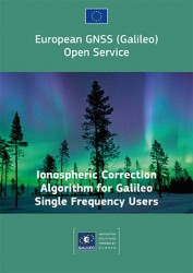
The GSA has just published a new document on the NeQuick Ionospheric Model, used to compensate ionospheric errors on Galileo and other GNSS signals. The document, titled “European GNSS (Galileo) Open Service Ionospheric Correction Algorithm for Galileo Single Frequency Users,” and downloadable, contains detailed description and results from years of intense research.

    Ionospheric Model

    The NeQuick model improves accuracy levels globally when using single-frequency services, even during hyperactive periods of the 11-year solar cycle, according to the GSA.

    (Last year, authors from the European Space Research and Technology Centre (ESTEC) at the European Space Agency (ESA) published an article in GPS World magazine, “Innovation: the European Way,” as the Innovation column edited by Richard Langley. From Langley’s introduction to the article: “The ionosphere is a dispersive medium for radio signals, so by making measurements simultaneously on two frequencies transmitted by a satellite, most of the effect of the ionosphere can be removed. However, single-frequency devices such as most vehicle navigation and handheld receivers don’t have the luxury of dual-frequency correction. These devices must rely on a single-frequency correction model. The coefficients for such a model are included in the navigation messages transmitted by all GPS satellites. Known as the Ionospheric Correction Algorithm or Klobuchar Algorithm, it removes at least 50 percent of the ionosphere’s effect.

    “The Galileo satellites also include the parameters of an ionospheric algorithm, called NeQuick G, in their navigation messages. In this month’s column, the Galileo system design team describes the novel European way for modeling the ionosphere for single-frequency users and compares its performance to the current GPS approach.”

    The online version of the Innovation column contains an extensive Further Reading list, including resources on the GPS (Klobuchar) ionospheric model.)

    Receivers operating in single-frequency mode may use a single-frequency ionospheric correction algorithm,which is given in the report in the form of two equations, to estimate the ionospheric delay on each satellite link. The Effective Ionisation Level, Az, is determined from three ionospheric coefficients (broadcast within the navigation message) and the Modified Dip Latitude (MODIP) at the location of the user receiver. MODIP is expressed in degrees and a table grid of MODIP values versus geographical location is provided together with NeQuick G model. The receiver then calculates the integrated Slant Total Electron Content along the path using NeQuick G and converts it to slant delay using a stated equation for ionosphere group delay (delay on the pseudo-range or signal code phase), neglecting higher order terms.

    A further section of the report describes practical guidelines for the implementation of the single-frequency ionospheric model within Galileo user receivers, with sub-sections detailing:

    • Zero-valued coefficients and default Effective Ionisation Level;
    • Applicability and coherence of broadcast coefficients;
    • Effective Ionisation Level boundaries;
    • Integration of NeQuick G into higher level software;
    • Computation rate of ionospheric corrections.

    In a document annex titled “Performance Results,” the performance of the model is compared with that of the GPS Ionospheric Correction Algorithm (ICA) algorithm, also known as the Klobuchar model.

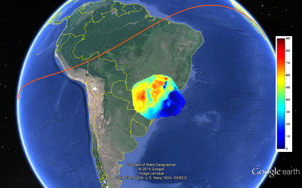
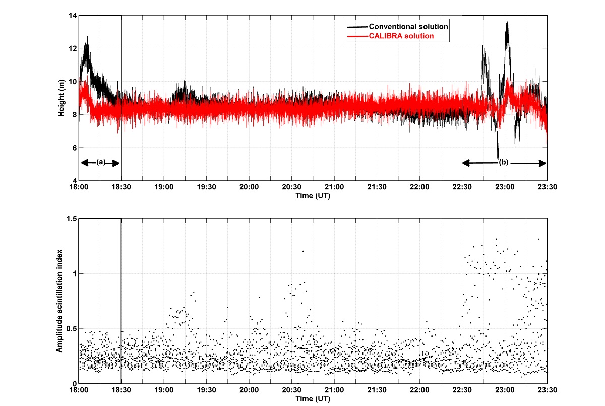
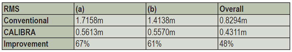
    “As an example of the behavior of the two models as a function of the time of day, the delay computed using Klobuchar and NeQuick G are plotted as a function of the satellite elevation and of UTC in Figure 5. For this example, in order to have a direct comparison between the two models, the delays computed using Klobuchar and NeQuick are compared with respect to the delay estimated using Global Ionospheric Map (GIM). The plots have been computed for a station in latitude [deg] 40.8234, longitude [deg] 14.2161, altitude [m] 122.6590 m, using GPS satellite PRN 11 and for day 16 of year 2010 characterized by quiet geomagnetic activity.”

    GNSS-D&T-Figure-5

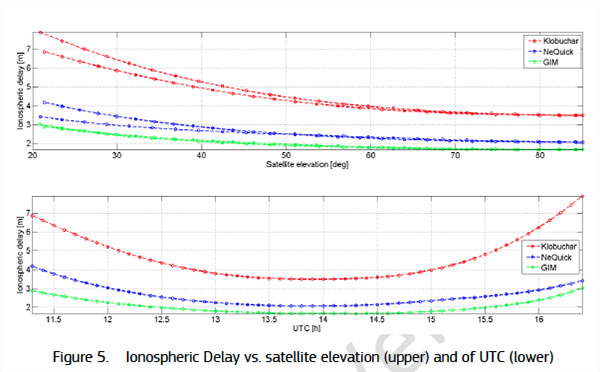
    Several further figures and tables within the document annex give more details on the performance results obtained.

    The NeQuick electron density model was developed by the Abdus Salam International Center of Theoretical Physics (ICTP) and the University of Graz. The adaptation of NeQuick for Galileo single-frequency ionospheric correction algorithm (NeQuick G) has been performed by the European Space Agency (ESA) involving the original authors and other European ionospheric scientists under various ESA contracts.

    GNSS Market

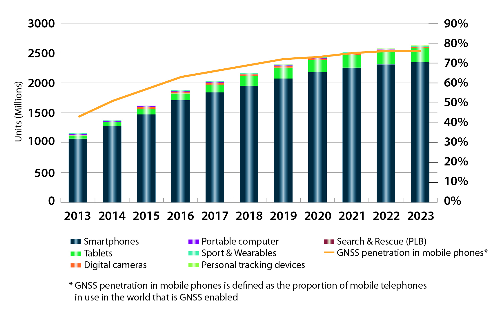
    In market forecasts, Diani related some high-level results from the GSA’s 2015 GNSS Market Report.  Among other insights, the GSA predicts that the installed base of GNSS devices will triple by 2023, with per capita rates of 2.5 in North America (currently 1.4), and 2.3 in Europe and Russia (now 1.1 and 0.8, respectively). Around the rest of the world, in eight years nearly every person, on average, will possess a GNSS device. Currently rates are 0.5 in South America, 0.2 in Africa, and 0.4 in the Middle East and non-Russian Asia.

    Galileo Services: Proposal for an Industry Policy

    Axelle Pomies of Galileo Services, an association of industry players active in GNSS applications, stressed the need for a comprehensive, assertive industry policy to support the development of EGNOS/Galileo downstream sector, leading to growth, job creation, and autonomy for Europe.

    As stated in her presentation, GNSS market trends do not currently favor Europe, as the continent aggregately currently holds a market share of less than 20%, whereas the usual European market share in other high-tech sectors is around 33%. European GNSS downstream industry suffers from a competitive disadvantage vis-à-vis industry from other regions, because dedicated national programs/strategy in the United States, Russia, China, and Japan support competitiveness of their respective industries and enhance GNSS market take up, including funding from R&D to manufacturing capabilities; regulation; and massive public procurement. Europe has none of these, or at least not to the same degree.

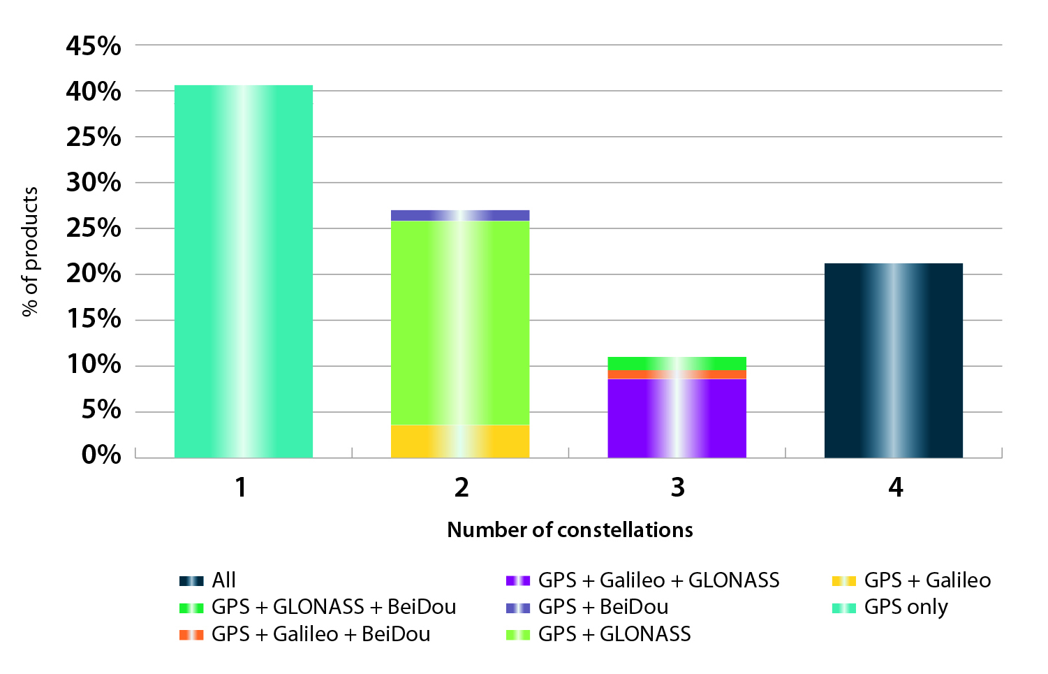
    Among the risks this entails for European Union autonomy are that Galileo may not be used as intended; there is little predicted interest for most user applications to track four constellations. Meanwhile GPS, GLONASS and BEIDOU are already in place.

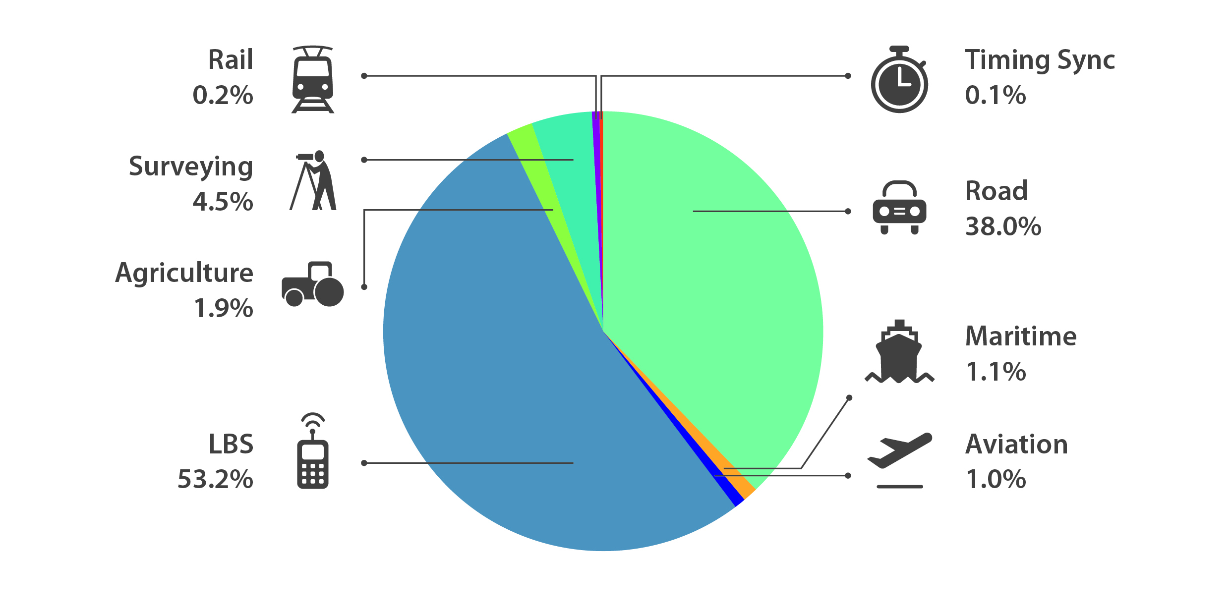
    She cited a number of key GNSS application markets where European industry must position itself strongly and securely. In her view, the most promising markets in terms of growth potential and strategic placement include:

    • Road (intelligent transport systems, connected vehicles, and advanced driver asisstance systems, or ADAS)
    • agriculture
    • autonomous/unmanned vehicles
    • rail
    • timing
    • critical infrastructures
    • multimodal logistics
    • defence
    • Internet of Things.

    In that regard, Pomies posited the necessity of a comprehensive and assertive industry policy to support the development of EGNOS/Galileo downstream sector, with the goals of  fostering the use of European GNSS infrastructures; encouraging European Industry to develop EGNSS equip/apps; fostering the manufacturing of E-GNSS based solutions in Europe; and supporting the European industry competitiveness in the GNSS global market and fostering the emergence of European champions.

    Support from European and national institutions is necessary for the full success of the EGNOS programmes, she said, and she previewed the mid-May publication of a draft position paper from Galileo Services in this regard, for wide consultation within the European downstream sector.

    Follow www.galileo-services.org for its first appearance.

    Key Issues in Intelligent Transport and Location-Based Services

    Concluding the ENC plenary, Florence Ghiron of Topos Aquitaine, a regional council of satnav and intelligent transport companies in southwest France, focused on opportunities and risks for small-to-medium enterprises. One of her key points regarding the intelligent transport systems market: the long development paths of public and regulatory policy do not help SMEs grow.

    Today, several GNSS-based road schemes are already operational, but they tend to be limited to specific applications, to regional areas and/or to specific classes of vehicles, for example, trucks above a certain weight !

    Moreover, each country tends to work with their national champion. This has led to fragmentation of the targeted markets all over Europe. Thus, the need for interoperability between schemes is an increasingly important factor.

    Among her major recommendation for supporting application and business development:

    Support GNSS stakeholders at promoting their innovative GNSS applications towards the largest possible community. This encompasses:

    • Visibility of GNSS mature solutions/applications

    • Cost-benefit analyses for already developed GNSS-applications

    • Identification of the best ways/means to help SMEs  promote their offers towards public purchasers

    • Development of a Directory of European regional and national contact points

    She further proposed additional funding mechanisms for SMEs to bridge the gap between the R&D step and the industrialization/market development phase.

    Finally, help medium/small regions and cities to purchase or procure the innovative GNSS-ITS applications they need to answer their public transportation/mobility needs.

    Further information on the Topos project SUNRISE (Strengthening User Networks for Requirement Investigation and Supporting Entrepreneurship), a European project managed by the GSA, may be found at www.topos-aquitaine.org.

    Back to Bordeaux in October

    Both Diani and Ghiron closed their presentations with invitations to return to Bordeaux in October for the Intelligent Transport Systems World Congress, themed “Towards Intelligent Mobility: Better Use of Space.” GNSS looks to take a more central role than ever in this far-reaching economic segment.

  • ESNC 2015 Now Accepting Submissions

    International Kickoff for the 2015 ESNC is scheduled for April 21 in London.
    Winners in the 30 categories will be announced in October.

    The 2015 European Satellite Navigation Competition (ESNC), an international innovation competition that recognizes the best ideas in satellite navigation, will run from April 1 to June 30. Winners will be announced in October.

    There are more than 20 regions participating, and the ESNC will award prizes worth a total of €1 million in 30 categories.

    “Satellite navigation is an essential element of modern mobility and a key technology in particular, in the age of a data-driven economy. This is exactly where the European Satellite Navigation Competition comes in. It provides a public platform to the creative community in order to help promising ideas turn into solutions that are commercially mature and generate added value for society,” said Alexander Dobrindt, Germany’s Federal Minister of Transport and Digital Infrastructure (BMVI).

    A jury of international research and industry experts will select the year’s overall champion among the winners of the categories, which comes with an additional €20,000 and access to a six-month incubation program in the champion’s preferred region.

    ESNC_London_kickoff_2015
    International kick-off for the 2015 ESNC is scheduled for April 21 in London.

    “As the Galileo satellite constellation continues to expand, efforts to promote corresponding applications will become increasingly important. This is where the ESNC is already playing a key role,” said Matthias Petschke, the European Commission’s director of satellite navigation programs. “As such, the Commission is definitely looking forward to seeing the creative and innovative GNSS-based applications submitted this year.”

    This year’s special topic prizes are being sponsored by the European GNSS Agency (GSA), the European Space Agency (ESA), the German Aerospace Center (DLR) and the Ministry of Transport and Digital Infrastructure (BMVI) in cooperation with the German Federal Ministry for Economic Affairs and Energy (BMWi). Entrants may submit prototypes to the GNSS Living Lab Challenge, while the University Challenge specifically addresses students and research assistants.

    “Those who enter the ESNC benefit in particular from our global network, which provides them with tailored support in developing their business concepts and bringing them to market,” said Thorsten Rudolph, managing director of Anwendungszentrum GmbH Oberpfaffenhofen.

    All of the information on this year’s prizes, partners, and terms of participation is available at the ESNC website.

  • GSA’s 2015 Report Dives Deep into Global GNSS Market

    GSA’s 2015 Report Dives Deep into Global GNSS Market

    FIGURE 1. Cumulative core revenue, 2013–2023.
    FIGURE 1. Cumulative core revenue, 2013–2023.

    2015 GNSS Market Report: European GNSS Agency Provides a Fresh Look at Worldwide Growth

    The fourth edition of the European GNSS Agency’s (GSA’s) GNSS Market Report provides a comprehensive source of knowledge on this dynamic global market. The report has become a key reference for organizations building their GNSS market strategies. The new edition provides:

    • Comprehensive updates on previous analyses;
    • New statistics of the GNSS receiver capabilities of the 31 top global manufacturers, offering in total more than 300 models;
    • Insights on the GNSS industry and regional shares of the GNSS market
    • A more granular segmentation of the global GNSS market, namely: European Union (EU28); North America (including the United States, Canada, Mexico); Asia-Pacific (including China, Japan, Australia, India, Republic of Korea); Non-EU28 Europe (Norway, Switzerland, Russia, Ukraine);  Middle East and Africa (Turkey, Israel, South Africa, UAE, Saudi Arabia); South America and Caribbean (including Brazil, Argentina, Colombia, Guatemala)
    • Information on a new market segment: Timing and Synchronization
    • Plus additional applications within existing segments, such as recreational navigation, fishing vessels, personal locator beacons, emergency locator transmitters and digital tachograph.
    TABLE 1. Top 10 companies in each group based on 2012 revenue.
    TABLE 1. Top 10 companies in each group based on 2012 revenue.

    Key Findings

    Top-line insights from the fourth GSA GNSS Market Report:

    • The global GNSS downstream market is forecast to increase by 8.3 percent annually from 2013– 2019, then slow down to 4.6 annually around 2023, growing on average faster (7 percent) than the forecast global GDP in this period (6.6 percent).
    • The installed base in the mature regions of EU28 and North America will grow steadily (8 percent per year) to 2023. The primary region of growth will be Asia-Pacific, which is forecast to grow 11 percent per year from 1.7 billion in 2014 to 4.2 billion devices in 2023 — more than the EU and North America together. The Middle East and Africa will grow at the fastest rate (19 percent per year), but starting from a lower base.
    • Location-Based Services (LBS) and Road dominate cumulative GNSS revenues, driven by booming sales of smartphones and in-vehicle devices, location-aware applications and data services.
    • With emerging economies catching up in terms of GNSS devices per capita, the Digital Divide will narrow, driven by the take-up of smartphones. The growing dominance of smartphones (3.08 billion in 2014) is foreseen as the most popular platform to access LBS.
    • In the analysis of the capabilities of GNSS receivers and chipsets, it is reported that more than 60 percent of currently available receivers and chipsets support a minimum of two constellations with more than 20 percent supporting all four of them.
    FIGURE 2. SUPPORTED CONSTELLATION BY RECEIVERS Chart shows the percentage of available receivers capable of tracking signals from one GNSS (such as GPS only), two GNSS (GPS + Galileo, GPS + GLONASS, GPS + BeiDou), three GNSS (GPS + Galileo + GLONASS, GPS + Galileo + BeiDou, GPS + GLONASS + BeiDou) or tracking signals from all constellations at the same time. The percentages add up to 100 percent. We can conclude that almost 60 percent of all available receivers, chipsets and modules are supporting a minimum of two constellations, showing that multi-constellation is becoming a standard feature across all market segments.
    FIGURE 2. SUPPORTED CONSTELLATION BY RECEIVERS Chart shows the percentage of available
    receivers capable of tracking signals from one GNSS (such as GPS only), two GNSS (GPS
    + Galileo, GPS + GLONASS, GPS + BeiDou), three GNSS (GPS + Galileo + GLONASS, GPS +
    Galileo + BeiDou, GPS + GLONASS + BeiDou) or tracking signals from all constellations at
    the same time. The percentages add up to 100 percent. We can conclude that almost 60
    percent of all available receivers, chipsets and modules are supporting a minimum of two
    constellations, showing that multi-constellation is becoming a standard feature across all
    market segments.

    New Charts

    The report includes new infographics presenting:

    • Global GNSS downstream market size, core and enabled (2013 to 2023)
    • GNSS industry share by region (2012)
    • The global shares of companies among components manufacturers, systems integrators and value-added service providers (2012)
    • Capability of GNSS receivers and chipsets, all segments (2015)
    • Supported constellation by receivers and chipsets , all segments (2015)
    • Detailed analysis of key GNSS segments: LBS, Road, Aviation, Rail, Maritime, Agriculture, Surveying, Timing and Synchronization, quantified in terms of:
      • Shipments of GNSS devices by application and region (2013 to 2023)
      • Installed base of GNSS devices by application and region (2013 to 2023)
      • Core revenues from GNSS device sales by application and region (2013 to 2023)
      • Capability of GNSS receivers and chipsets (2015)
      • Supported constellation by receivers and chipsets (2015).
    FIGURE 3. LOCATION-BASED SERVICES SECTOR GNSS shipments by type; GNSS penetration in mobile phones is defined as the proportion of mobile telephones in use in the world that is GNSS enabled.
    FIGURE 3. LOCATION-BASED SERVICES SECTOR GNSS shipments by type; GNSS penetration in
    mobile phones is defined as the proportion of mobile telephones in use in the world that is
    GNSS enabled.
    FIGURE 4. ROAD SECTOR Core revenue from GNSS device sales and services by application.
    FIGURE 4. ROAD SECTOR Core revenue from GNSS device sales and services by application.

    Methodology

    The “GSA GNSS Market Report” is compiled by the GSA and the European Commission and was produced using the GSA’s systematic Marketing Monitoring and Forecasting Process.

    The underlying market model uses advanced forecasting techniques applied to a wide range of input data, assumptions, and scenarios to forecast the size of the GNSS market in terms of shipments, revenue and installed base of receivers.

    Historical values are anchored to actual data in order to ensure a high level of accuracy. Assumptions are provided by expert opinions and model results are cross-checked against the most recent market research reports from independent sources, before being validated through an iterative consultation process with sector experts and stakeholders.

    Download

    Readers can download the entire 29-MB report free.

  • An Early Gift from — and for — Galileo

    They said it wasn’t possible — well to be frank, I said it wasn’t possible – but one of the two “misplaced” Galileo satellites, plucky Doresa, has delivered an early Christmas present to the European GNSS community by providing a first fix on Tuesday, December 9. The signal was received at the European Space Agency’s (ESA’s) technical centre in Noordwijk, the Netherlands and at the Galileo In-Orbit-Validation (IOV) test station at Redu in Belgium. Doresa teamed with the remaining three functioning Galileo IOV satellites to provide a Galileo positioning data first fix with horizontal accuracy better than two metres.

    Since then fixes have also been performed using Galileo’s Public Regulated Service (PRS), the civilian encrypted highest-precision signal and one of the constellation’s unique selling points.

    The satellite had transmitted its first navigation signal in space on November 29, following its attainment of a safer, more stable, and more circular orbit with the perigee some 3,500 kilometres higher than its original placement.

    Doresa’s salvage has been a slow and steady journey since it was placed, with sister satellite Melina, into a fairly useless orbit in August following a launch anomaly. The original orbit, with a 26,000-kilometer apogee and a 13,800-kilometer perigee, prevented their use for navigation services because they were too low during part of their orbit to sense the horizon and correctly determine their own position. They were also getting a daily dose of radiation from the Van Allen belts.

    Elevation

    The elevation of the satellite started in late October and involved 11 firings of Doresa’s on-board thrusters. The craft now has only 15 kilos left from its original 65 kilo fuel payload but, given the fact that normally Galileo satellites are not required to make regular orbital manoeuvres, ESA engineers estimate this should be enough for a good 12 years of operation in the new orbit.

    The next stage will be to repeat this manoeuvre with the second Full Operational Capability (FOC) satellite, Melina, according to a plan to get that into a similar orbit by the New Year. Pending tests of their positioning, navigation, and timing payloads, the two spacecraft are then likely to be able to contribute to the future Galileo navigation constellation. This was confirmed by Didier Faivre, ESA’s director for navigation, during the agency’s ministerial council meeting on December 2 in Luxembourg.

    This end result is the best possible scenario given where the satellites were left after launch and is a considerable triumph for ESA’s mission control teams and flight engineers. Doresa is now able to use its Earth sensor continuously and keep its antennae orientated towards the Earth. Despite more than a month’s exposure to the Van Allen radiation, testing so far has shown no ill effects.

    “The very good geometry of the satellites in the sky relative to the receivers helped us to achieve this result, plus the signal strength of the fifth satellite,” explained Gustavo Lopez Risueno, coordinating the receiver team at the Navigation Laboratory in ESA’s ESTEC technical centre.

    The satellite signals should be usable immediately, in combination with additional navigation message information provided through ground networks, with mass market receivers. In fact the ESTEC Navigation Laboratory, working in conjunction with the European Commission and the European GNSS Agency (GSA), have already performed position fixes with both Galileo and GPS satellites using only navigation-assistance information.

    With some adjustments to the Galileo network’s ground infrastructure, it looks like Doresa and Melina will be able to carry out most of the roles they were originally designed to do. They are the first of 22 Galileo FOC satellites to be built by OHB and launched by ESA over the next few years.

    Toasted antennae

    More good news. The problem with Galileo’s fourth IOV satellite, named Sif, that took it out of action at the end of May seems to have been characterised and — again — indicates that the satellite is not a complete loss to the constellation. While Sif’s E5 and E6 frequency bands are definitively blown, the satellite’s E1 Open Service band should be capable of broadcast.

    The problem appears to have been a defective antennae. The four IOV satellites utilise one antennae design, while the FOC satellites have a different design. Fortunately there is no sign of a similar issue with the three other IOV craft, but they have been operating on reduced power as a precaution while the root cause of Sif’s failure is determined. ESA is currently fail-testing an example of the culprit antennae in the laboratory to see if the failure mode can be characterised.

    “One of the possible root causes links the problem with the power emitted by the antenna. When we know more we’ll decide what to do with the other three. Since this event occurred in May and June, no more issues have arisen,” Faivre said.

    Agreement

    This is all a remarkable turnaround and good news for the wider European GNSS community and those stakeholders who have invested in the Galileo programme and its burgeoning application industry. Let’s hope the good fortune continues through 2015.

    The administrative side of things is certainly moving on with the signing in October of an agreement which delegates a range of exploitation tasks for Galileo from the European Commission to the GSA, providing a framework and budget for the development of services and operations through to 2021.The signing of the agreement is an initial step towards the full Galileo Exploitation Phase. Current planning calls for this exploitation phase to be progressively rolled out from 2015, with full operability scheduled for 2020.

    “With Galileo, we aim to provide a tangible service to European citizens, and this Delegation Agreement ensures we have the tools and funding necessary to achieve this,” said GSA Executive Director Carlo des Dorides. The agreement was signed by Daniel Calleja Crespo of the European Commission and des Dorides. The document specifically sets the actions to be implemented, the amount of funding provided, and the conditions for the overall management.

    Innovation

    In the same month, the First Satellite Masters Conference took place in Berlin on October 23 and 24. The conference encompassed the 2014 edition of the European Satellite Navigation Competition (ESNC). The event was a great showcase for the innovation, skill, and passion of the entrepreneurs, usually young, who are building the satellite application market in Europe.

    For example, the winner of the GSA special prize at ESNC 2014 is developing Galileo modules for the Google Ara modular smartphone concept, a potential game-changer for positioning in the mobile-phone market. Ara uses interchangeable modules to deliver a smartphone that can be whatever a user wants it to be, complete with first- and third-party components including sensors, cameras, radio antennas, and more. Consumers will be able to order them as of January 2015.
    Google developers believe an Ara smartphone will last multiple years, much longer than current hardware, since it won’t be obsolete nearly as quickly. Further, Ara could open the smartphone market to billions of new users across the globe.

    I spoke with Giovanni Vecchione of Deimos Space, who received the € 40 000 GSA/ESNC prize during the awards ceremony at Deutsche Telekom’s magnificent headquarters in the German capital.

    “With a traditional chip structure, all of a smartphone’s functions are currently combined into a single component, which makes it difficult to add or change a function,” explained Giovanni. “With a modular structure, you have the option to simply switch out a component, meaning a smartphone’s capabilities can be easily enhanced.”

    Vecchione’s innovation is to use another of Galileo’s unique selling points: the E5 broadband signal. While mass market smartphones will use the E1 signal, the availability of high-end phones offering enhanced accuracy through the use of the E5 signal will appeal to many users. A second module will implement an external antenna interface. Together these developments could deliver an ARA phone offering high precision (centimetre-level accuracy) positioning and multipath-resistant solutions.

    Wishing you all a very peaceful and prosperous New Year and hoping Santa has your coordinates accurately entered in his sleigh satnav!

    A bientôt, as they say in these parts.

  • GSA Kicks Off EGNOS GEO Transponder Service Contracts

    On November 25, the European GNSS Agency (GSA) kicked off the contracts for two new EGNOS GEO transponder services provided by SES.

    The kick-off was done with the support of the European Space Agency (ESA) and the EGNOS service provider ESSP. Initially awarded and signed by the European Commission, in line with a new delegation agreement  between the commission and the GSA, responsibility for the oversight of the contracts has been assigned to ESA.

    The contracts regard the provision of signals from two EGNOS transponders embarked on-board the SES-5 and ASTRA-5B geostationary satellites, both operated by Luxembourg-based SES. The ground-based signals are generated via redundant uplink stations located in Betzdorf, Luxembourg and Redu, Belgium.

    The signals include the navigation messages computed by the EGNOS Mission Control Centers. Both satellites are capable of transmitting dual-frequency signals compliant with GPS L1/L5 and Galileo E1/E5 signal specifications. The signals will be introduced into the EGNOS service provision (L1-only signals) between 2015 and 2016.


  • Directions 2015: Galileo Looks Ahead to Early Services

    GPS-directions-GalileoThe European GNSS Agency (GSA) hosted the ninth meeting of the International Committee on Global Navigation Satellite Systems (ICG) in November at its headquarters in Prague, Czech Republic. The event is an opportunity for GNSS providers to present the status and future plans for their systems, and an opportunity for ICG members, associate members, and observers to provide updates on recent developments with regard to GNSS services and applications.

    Representatives from the world’s leading global and regional GNSS programs were invited to provide the assembly with a “state of play” for their respective systems. Joining GPS, GLONASS, BeiDou, IRNSS/GAGAN, and QZSS was Galileo, represented by Christian Siebert, Head of Unit, Galileo and EGNOS: Applications, Security and International Cooperation, DG Enterprise and Industry, European Commission.

    A Secure Foundation

    The key message coming from Prague was that, despite the launch anomaly in August, the Galileo program has a secure foundation for moving forward. For instance, it has been given a stable seven-year perspective, a substantial budget, and a new exploitation-driven governance scheme. In terms of budget, the European Commission has allocated €1.930 billion for deployment and €3 billion for exploitation — with an additional €1.580 billion allocation for European Geostationary Navigation Overlay Service (EGNOS) exploitation.

    The new governance scheme is based on a recently announced agreement between the European Commission and the GSA; the agreement delegates a range of exploitation tasks for Galileo to the GSA. Serving as an initial step towards the full Galileo Exploitation Phase, the GSA’s responsibilities now include:

    • provision and marketing of the services;
    • management, maintenance, continuous improvement, evolution and protection of the space and ground infrastructure;
    • research and development of receiver platforms with innovative features in different application domains;
    • development of future generations of the system;
    • cooperation with other GNSS;
    • all other required activities to ensure the development and smooth running of the system.

    This new budget and governance structure ensures the Galileo program’s stability for the next seven years, according to a GSA press release. The agency will progressively manage exploitation activities as delegated by the European Commission, which serves as the program’s supervisor.

    At the same time, the European Space Agency (ESA) will continue its role for system design and development.

    A Range of Successes

    “The past year has seen the program achieve a range of milestones,” said Siebert. “The Galileo In-Orbit Validation Phase was successfully concluded, the ground infrastructure deployment finalized for initial operations, and the new satellite design qualified.”

    Even with the satellite launch anomaly that left two satellites in the wrong orbit, the ESA just announced that one of these satellites will soon make a series of maneuvers as a prelude to its health being confirmed. The aim is to raise the lowest point of its orbit — its perigee — to reduce the radiation exposure from the Van Allen radiation belts surrounding Earth, as well as put it into a more useful orbit for navigation purposes. If the operation is successful, the second satellite will follow suit.

    As to the cause of the anomaly itself, Siebert said Arianespace has established an inquiry board to investigate, and the European Commission and ESA continue to analyze the best options for recovering the initial mission to the best possible extent. A new launch sequence will be confirmed in the near future.

    That being said, the deployment plan for the Galileo constellation is secured, with 26 satellites ordered (four IOV and 22 FOC) and launcher service contracts for the full constellation signed with Arianespace. As to the new satellite design, production proceeds at a good pace, with full operational capability (FOC) satellites being built by OHB Systems and navigation payloads provided by Surrey Satellite Technology Ltd.

    In terms of services, the Search and Rescue Forward Link Alert Service successfully tested the networked ground segment last April, and positioning accuracy exceeds expectations.

    As to the Commercial Services Demonstrator, the main objective of the demonstrator was to test and characterize the high accuracy and authentication performance obtainable with the Galileo Commercial Service. The first results are extremely promising, with high accuracy already demonstrated through PPP information transmitted via E6B and used to enhance both Galileo and GPS. 

    Siebert noted that the ongoing Receiver Test Campaign supports manufacturers to ensure that Galileo is well implemented in chipsets and receivers. To accomplish this, the program continues to develop dialogs with the user/receiver segment to understand the market situation and follow up adoption of Galileo.

    Looking Ahead

    With this secure foundation, looking towards 2015 and beyond, Galileo is set to deliver a reliable, high-quality service to the world, according to EC and ESA spokespersons presenting at the ICG. “With its substantial budget and exploitation-focused governance scheme, it will continue to evolve and introduce innovative features,” Siebert affirmed.

    Next steps for the program include a gradual introduction of the early phase of service delivery, which will rely heavily on interaction with users. Early services will be run with continued infrastructure deployments. The program will soon conduct a service validation campaign, along with finalizing the Commercial Service definition and developing a long-term service plan. 

    “This service plan will be aligned with the trend of most user communities moving towards service levels based on a multi-constellation approach,” concluded Siebert. “Knowing this, it is crucial to continue to improve signal compatibility and interoperability of the Galileo service with other providers and cooperate on building multi-constellation programs.”

    Group-ICG-2014
    Photo: Galileo
  • EC, GSA Plan Workshop on GNSS Receiver Technology

    On November 18, a Consultation Event will take place in Brussels on the subject of receiver technology. The event is being held to inform the stakeholders of the European GNSS receiver community about the format and timeline of funding opportunities for the period 2015-2020, and to gather input for the definition of R&D actions in the field of receiver technology.

    The event is being organized by the European Commission’s Directorate-General Enterprise and Industry,  in collaboration with European GNSS Agency (GSA).

    The workshop will consist of one panel session, during which stakeholders from industry, SMEs, academia, and technology institutes will be asked to debate and recommend important lines of research in receiver technology.

    Registration is now open on the Europa website. Interested participants are invited to fill in the registration form and to indicate which application area they are interested in and the fields of research that should be supported.

    The workshop will be held at the Committee of the Regions, Jacques Delors building, rue Belliard 99-101, room JDE 53, Brussels.