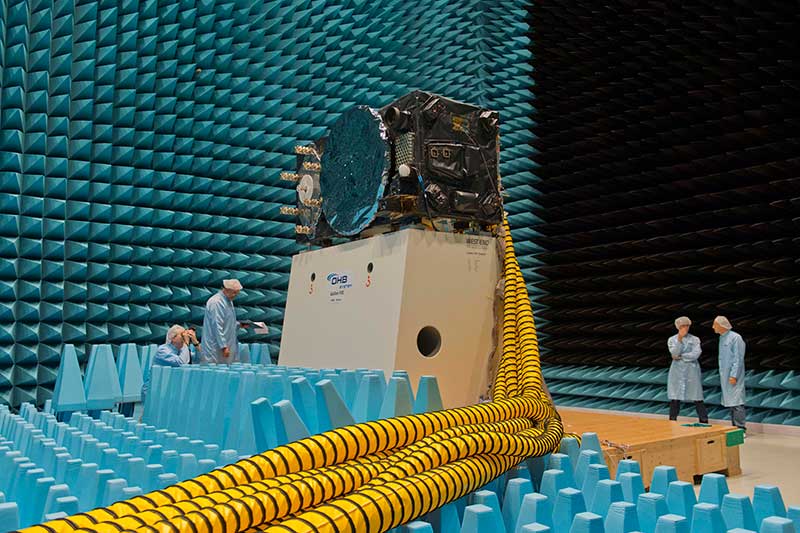
Inside the ESTEC Test Center, Galileo’s First Operational Capability first flight model, FM1, prepares for passive intermodulation testing in the Maxwell electromagnetic facility. (Photo: ESA-Anneke Le Floc’h)
Gazing through soaring plexiglass walls at the space simulation room of the European Space Agency’s Test Center in the Netherlands affords a glimpse into scientific history.
I felt a frisson, a highly regimented frisson if you will, of vicarious thrill for the rigors, rhythms and methods of research and testing as I toured the center after giving a keynote at the agency’s Navigation Days. Here, the final birthing touches were administered to transmitters beaming forth the Second Golden Age of satellite-based navigation.
One can debate which constellation combination will prove most fruitful to users: GPS plus GLONASS, GPS plus BeiDou, GPS plus Galileo (note the common term). I believe it will be the last, because of the close synergy and symbiosis of the two commercial arenas, North America and Europe.
All Galileo Full Operational Capability (FOC) satellites had their mettle and metals probed, radiated, bombarded, shaken and shocked here before they journeyed to space. The test center’s role is to verify, intensively and for months per satellite, that it can perform well for the whole of its planned lifetime.
A mass property test checks that the center of gravity and mass are aligned within design specifications, so that the satellite’s orientation can be accurately and economically controlled with thruster firings in orbit, prolonging work life by conserving propellant.
A five-week thermal-vacuum test runs inside a 4.5-meter diameter stainless steel vacuum chamber, the Phenix. An inner thermal tent heats to simulate solar radiation and cools with liquid nitrogen to create the chill of sunless space.
In the Maxwell test chamber, spiky radio-absorbent anechoic walls test electromagnetic compatibility to ensure that all systems operate together without interference. Noise horns generate more than 140 decibels to simulate a violent launch. A quad shaker table vibrates the satellite up, sideways and down, as accelerometers search for hazardous internal vibration, gathering data across hundreds of channels.
Altogether a severe trial, a crucible from which the FOC satellites emerge certified and ready for space.
Oh, that we humans were similarly tested before placement in positions of power.
LandViewer, a cloud service developed by EOS Data Analytics, provides access to satellite data and fast-paced analytics. In recent months, it has undergone numerous updates, which have expanded the existing catalogue of satellite imagery, introduced more tools for analysis and added other new features.
By the end of 2018, free space and airborne data available for browsing, analysis and download via LandViewer included imagery from the European Space Agency’s (ESA’s) Sentinel-2 and Sentinel-1, NASA-USGS’s Landsat 8 and previous missions, MODIS, CBERS-4 and NAIP.
This broad selection of Earth observation data has grown even larger with the addition of high-resolution commercial imagery from Airbus, SpaceWill and SI Imaging Services.
LandViewer has evolved into a single platform. On top of open-source data, users can freely explore the potential of commercial data with global coverage, short revisit periods, and spatial resolution up to 40 centimeters.
The current catalogue includes imagery from Pléiades 1a/1b, SPOT 5, SPOT 6 and SPOT 7, along with KOMPSAT-2, 3, 3A and SuperView. The high-resolution imagery browser offers free preview, automatic price calculation by selected area, and fast image delivery within three business days via cloud EOS Storage.
Preview of KOMPSAT-3A image collected over Shanghai Hongqiao International Airport on Oct. 29, 2018. (Photo: EOS)
Long-term observations. An abundance of available data, such as weekly updated Sentinel-2 imagery and historical Landsat data, has made it much easier to monitor changes over long time spans. Rather than taking a long time to select and process years of satellite data to get a multitemporal perspective, the LandViewer’s new Time Series Analysis will crunch the remote sensing data and deliver the results in an easily interpretable graph.
Sentinel-2 time series graph generated for agricultural fields in Kansas state. (Screenshot: EOS)
Users can select an area of interest (AOI), and a satellite dataset and a time period between 1 month and 10 years. The algorithm can then pick all imagery with minimum cloudiness and calculate NDVI, NDWI or NDSI in just a few moments. By default, the generated Time Series graph contains lines (representing the min, max, mean and std values) that can be hidden or displayed for convenience; whenever an unusual spike or drop in values is noticed, a satellite scene that represents that part of the curve can be visualized to establish the cause. The results can be downloaded either as an image (.png), or a .csv file for working in Excel.
Enhanced vegetation analysis. Users searching for an in-depth look at vegetation cover can use LandViewer’s new spectral indexes: SAVI, EVI, ARVI, GCI, SIPI and NBR. These indexes complement generalized NDVI analysis by making corrections for atmospheric and topographic effects or soil brightness influences, depending on vegetation density, climate and elevation in the area of interest.
The NBR index is designed to highlight burned areas against healthy vegetation; the difference between pre-fire NBR and post-fire NBR values can be applied to estimate the severity of burn.
The use of several indexes simultaneously enables better insight into plant health and helps to identify stressed or infected vegetation at an early stage.
Sentinel-2-derived SAVI analysis of an arid agricultural region in Saudi Arabia. (Screenshot: EOS)
User-friendly legend and area calculation. Another new LandViewer feature, the index legend, is designed to solve the problem of interpreting the index results, a common issue for new users. Now when a spectral index is applied over the selected territory, the user can view a detailed legend, where each color-marked class contains a short description.
For example, calculation of NDVI will identify and highlight areas with “dense”, “moderate”, “sparse vegetation”, “open soil” or “no vegetation”.
Screenshot: EOS
Another new time-saving functionality is that the area of each class within the spectral index legend is calculated automatically, in both square meters and by percentage.
Also, the expanded Area of Interest (AOI) tool enables bulk uploading of AOIs and speeds up work by allowing simultaneous visualization and fast switching of all AOIs on a map for imagery searches or new scene subscription.
Advanced zone analytics. By introducing the clustering function, EOS’ remote sensing experts and software developers have taken LandViewer’s spatio-temporal analytics to the next level. With this function, users can run unsupervised satellite data-based classification of an area up to 200 square kilometers into as many as 19 clusters (or zones). This process involves setting custom parameters (size/number of zones) and waiting a few moments for LandViewer to build a raster image of the area with color-marked zones, and a vector layer outlining the boundaries. Both outputs can be downloaded.
This scalable analysis can provide various insights across agriculture, forestry, coastal monitoring and other industries. For example, a farmer can make use of convenient color mapping of zones within the field based on NDVI values for precise in-field navigation and crop management.
Engaging animations. With the informative spectral data contained in satellite image pixels, LandViewer has introduced a time-lapse animation feature allowing journalists and active social media users to create engaging animated stories and share them on the internet. Each GIF can contain up to 300 scenes, with indexes or band combinations applied. From calving of glaciers to construction of new stadiums, satellite imagery is full of information that’s worth watching and sharing with the world.
Spire Global, a space-to-cloud analytics company, is now using Galileo to offer GNSS radio occultation (GNSS-RO) products for the weather community. Radio occultation is the process of using satellites to measure how GNSS signals are refracted by the Earth’s atmosphere.
Two of Spire’s nanosatellites are the first to use Galileo signals to measure GNSS-RO profiles, a service now available to Spire’s global user base as a new tier of data for advanced weather prediction. The satellites launched on Nov. 29, 2018, from Sriharikota, India.
The satellites are part of the collaborative European Space Agency ARTES Pioneer Space-as-a-Service program, which aims to prove the value of using nanosatellites for space-based GNSS-RO.
With Galileo, Spire’s weather observation satellites can harvest approximately 25 percent of the total GNSS-RO profiles available from the existing GNSS satellite constellations in orbit today.
Spire operates 72 nanosatellites — also known as “cubesats” — and more than 30 ground stations throughout the world. The nanosatellites are developed, assembled and tested at Spire’s production facility in Glasgow, Scotland.
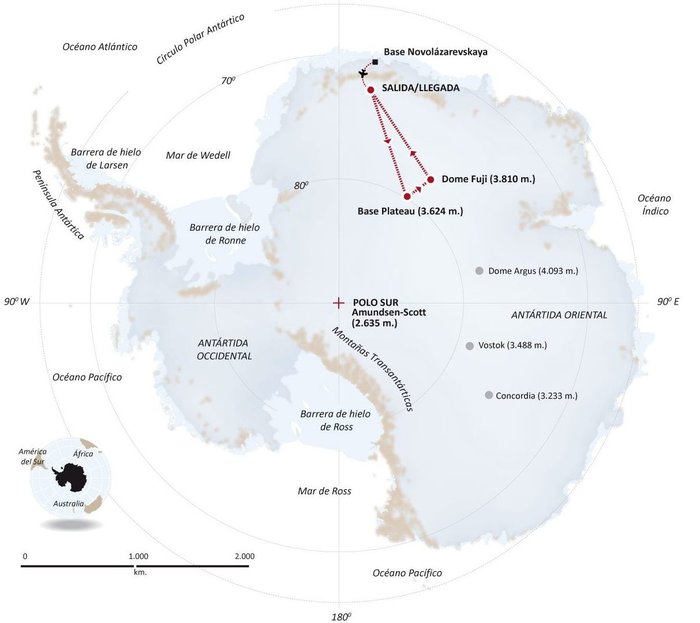
A kite-blown science expedition to the interior of Antarctica has made the most southerly positioning fixes yet made with Europe’s Galileo satellite navigation system.
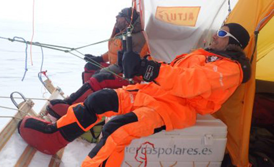
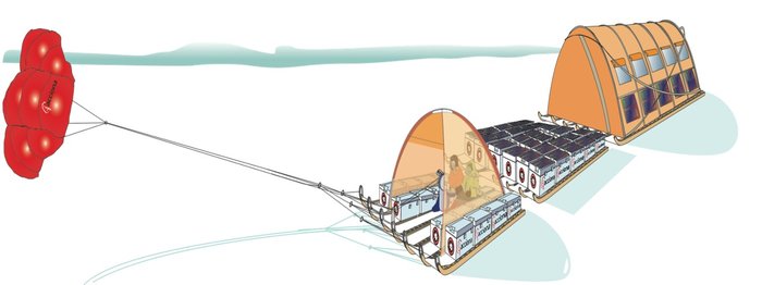
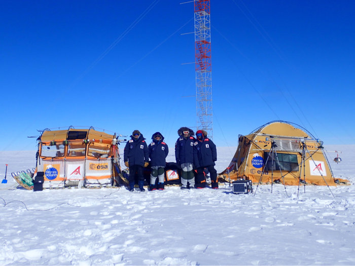
The Inuit WindSled is a multi-part sledge the size of a lorry, complete with mounted tents and solar power panels, pulled through the ice using a mammoth 150 sq. m. diameter kite. (Photo: Inuit WindSled via ESA)
Their measurements not only confirm Galileo performance at extremely high latitudes, but also offer knowledge of space weather events overhead. In particular they offer insights into the ionosphere — the electrically active upper layer of Earth’s atmosphere — above the southern continent, and the performance of Galileo software to correct ionospheric interference.
The four-person expedition left Russia’s Novolazarevskaya Base on 12 December last year. For more than 40 days they made their way to Dome Fuji, a 3810-meter-high ice dome in Eastern Antarctica — one of the coldest places on Earth. After reaching the high point on 21 January, they are now back at the Russian base.
The Inuit WindSled is a multi-part sledge the size of a lorry, complete with mounted tents and solar power panels, pulled through the ice using a mammoth 150 sq. m kite. (Graphic: ESA)
The “Antarctica Unexplored 2018-2019″ expedition, mounted by Spain’s Asociación Polar Trineo de Viento, is employing a unique zero-emission vehicle specially designed for polar exploration. The Inuit WindSled is a multi-part sledge the size of a lorry, complete with mounted tents and solar power panels, pulled through the ice using a mammoth 150 sq. m kite.
The Windsled’s inventor, Ramón Larramendi, is also the expedition leader. “This marks the first time we’ve climbed the Fuji Dome in a vehicle driven by the wind — everyone who reached there before relied on motorised vehicles. So this is also the first time we’ve traveled more than 2,400 km with more than 2,000 kg of cargo using a vehicle that does not pollute the Antarctic continent,” Larramendi said.
“We are also doing this in collaboration with ESA, among other scientific institutions, which is very important because it allows us to demonstrate this polar eco-vehicle has excellent possibilities for enabling science in the interior of the Antarctica continent,” Larramendi said.
The four-person “Antarctica Unexplored 2018-2019” expedition left Russia’s Novolazarevskaya Base on Dec. 12, 2018. For more than 40 days they made their way to Dome Fuji, a 3810-meter-high ice dome in Eastern Antarctica — one of the coldest places on Earth. (Graphic: ESA)
The expedition carries a total of 10 scientific experiments from different research institutions, covering fields such as climate change, meteorology and astrobiology. ESA’s involvement with the expedition is the Galileo Experimentation and Scientific Test in Antarctica (GESTA) project.
GESTA involves regular positioning fixes being made over the course of the expedition for all satellite navigation constellations in all kinds of weather and geomagnetic conditions encountered. ESA provided the satnav receiver, with GMV in Spain contributing an advanced signal recorder for data analysis.
One of the important aspects of the study is the monitoring of the ionosphere in such high latitudes during low solar activity. Ionospheric interference can degrade satellite navigation performance, and its incidence is linked to solar activity.
The expedition team with their Inuit WindSled at the high point of Dome Fuji. Note the ESA logo on the left tent of the WindSled. (Photo: Inuit WindSled via ESA)
GESTA is overseen by ESA’s Galileo Navigation Science Office, led by Javier Ventura-Traveset. “We are very pleased with this pilot scientific experience, having been able to collect Galileo measurements all over the expedition trip as planned,” said Ventura-Traveset. “The expedition reached latitudes near 80 degrees south, to our knowledge the most southerly latitude measurements ever-performed in-situ with Galileo in its current near-complete constellation status.
“We have also collected data from all other global satellite navigation systems and all available different frequencies, which will allow us also to assess multi-constellation solutions and compare their performance on these conditions. The expedition team kept in continuous contact via satellite with our office, allowing us to plan their activity, asking, for example, for dedicated data collections during space weather relevant events.”
“Once the expedition data are delivered, we will be able to assess Galileo positioning, navigation and timing capabilities at polar latitudes and how they are influenced by space weather events during low solar activity,” said Manuel Castillo, system engineer at the Galileo Navigation Science Office. “In particular, we will analyze if the occurrence of coronal holes is correlated with observed ionospheric interference. Coronal holes are open areas in the Sun’s outer layer, the corona, that allow the solar wind to leave the Sun and reach Earth, triggering moderate geomagnetic storms.
“At this moment in the 11-year solar cycle, with the Sun close to minimum activity, full-scale solar storms are not frequent, but the ongoing communication between the WindSled team and the Galileo Navigation Support Office allowed us to coordinate measurement times during the three minor geomagnetic storms the expedition experienced during the trip.”
A coronal hole in the Sun, observed by NASA’s Solar Dynamics Observatory on Jan. 5, 2019. (Photo: NASA)
The coronal holes triggering these geomagnetic storms were monitored, meanwhile, by Sun-watching missions such as NASA’s Solar Dynamic Observatory, the NASA-ESA SOHO and ESA’s Proba-2.
ESA’s Galileo Navigation Science Office is based in European Space Astronomy Centre, ESAC, near Madrid. It was set up in 2016 as a joint initiative between ESA’s Science and Navigation Directorates, coordinating scientific opportunities through interaction with the scientific community and the independent GNSS Science Advisory Committee.
The event, which is organized by the European Space Agency and ETH Zürich, will take place Sept. 4-6 in Zürich, Switzerland.
The event will bring together members of the European scientific community and their international partners involved in the use of GNSS — specifically Galileo — in their research. In addition, attendees will discuss opportunities where GNSS satellites can be used for scientific purposes.
According to event organizers, the colloquium will address five major areas of research, including:
Scientific applications in meteorology, geodesy, geodynamics, geophysics, space physics, oceanography, land surface and ecosystem studies, using either direct or reflected signals, differential measurements, phase measurements, radio occultation measurements, using receivers placed on the ground, in airplanes or on satellites;
Scientific developments in physics with a potential impact on future GNSS, particularly in testing fundamental laws of physics;
Aspects of metrology such as reference frames, on board and ground clocks, precise orbit determination and time and frequency transfer;
Scientific aspects of satellite navigation, positioning and its applications, such as signal propagation, tropospheric and ionospheric corrections, multi-constellation aspects, hybridisation with additional sensors and integrated navigation, precise positioning;
Transversal topics of interest to a wide number of scientific fields including collection of GNSS big data and GNSS scientific data archives; internet of things positioning for science; scientific payloads in GNSS satellites; novel disruptive technologies for science; the use of cubesats, HAPS, UAVs and autonomous vehicles for GNSS science; software receivers and low-cost SDR platforms; GNSS for space users and applications; and the topic of GNSS science and education.
The conference will be organized as a series of plenary talks, parallel half-day sessions and poster presentations throughout the duration of the event, event organizers add.
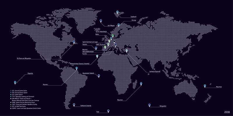
The European Space Agency (ESA) has received approval from the Galileo Security Accreditation Board to upgrade the global infrastructure running Europe’s Galileo satellite navigation system.
According to ESA, the resulting migration, set to start in February 2019, will incorporate new elements into the world-spanning system and boost the robustness of Galileo services delivered from the 26 satellites in orbit.
The system qualification campaign, which was run by the ESA Galileo project team in coordination with the WP1x system support team led by Thales Alenia Space in Italy, took more than a year to execute. It included more than 150 system tests — summing up to a total of 409 tests runs across Europe — in the various Galileo operational centers.
Galileo’s global ground segment. (Photo: ESA)
According to ESA, a major driver of this latest update was the growth of the Galileo constellation, which increased by 12 satellites through a trio of Ariane 5 launches in the last three years to become Europe’s largest.
The updated ground system incorporates a sixth telemetry, tracking and control station in Papeete, used to oversee Galileo satellite platforms, as well as an expansion of the number of antennas at the sites of uplink stations at Kourou in French Guiana, Reunion Island in the Indian Ocean and Noumea in French Polynesia.
In addition, receivers have been added to the Galileo sensor stations to ensure full redundancy.
“This marks the first update for Galileo’s operational infrastructure since it entered service,” said Edward Breeuwer, ESA Galileo system test and verification manager. “Galileo Initial Services began in December 2016, then last year we passed control of the system to our partner organization, the European Global Navigation Satellite System Agency, or GSA.
“This, therefore, marks a major step, but migration to the upgraded system should in principle be entirely transparent to Galileo users. We achieve this by taking advantage of the redundant elements of the Galileo system, taking them offline to update them while their operational counterparts continue to run.”
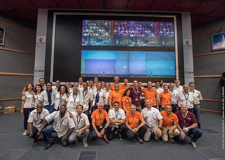
Countdown team at Kourou, Guiana control center for July’s four-satellite launch. (Photo: ESA/CNES/Arianespace, P. Baudon)
By Javier Benedicto Head, Galileo Programme department, European Space Agency
Since the declaration of initial services in December 2016, the European Space Agency (ESA) and the European GNSS Agency (GSA) have expanded Galileo’s system capabilities and service robustness with significant improvements of the ground segment and the last batch of four satellites launched by Ariane 5 in July. Once these satellites reach their final position and complete their in-orbit commissioning before the end of 2018, all 24 nominal slots of the Galileo constellation will be occupied.
Up to 22 satellites are planned to be commissioned in early 2019 and, eventually, the two FOC satellites injected in elliptical orbit should join the operational constellation after on-board software upgrade to provide for automatic health status flagging to users. This should lead to a total of 24 operational Galileo satellites supporting global PNT for users worldwide.
New Infrastructure Contracts
To further expand the system capabilities by 2020 and beyond, and reach Full Operational Capability (FOC), ESA has awarded new large industrial contracts in the context of the Exploitation Phase.
A contract to build and test another twelve Galileo satellites (so-called Batch-3) was awarded in 2017 to a consortium led by prime contractor OHB GmbH in Germany, with Surrey Satellite Technology Ltd in the UK as payload prime. These new satellites are based on the already qualified design of the previous Galileo FOC satellites. Production is advancing well, with first launch planned by late 2020.
With the Galileo constellation now expanded to 26 navigation satellites and plans to deploy additional Batch 3 satellites, the ground control infrastructure is undergoing a corresponding upgrades. In July, ESA awarded a new contract for the Galileo Ground Control Segment to GMV Aerospace and Defence, Spain. This contract includes upgrading the system architecture to manage a constellation of up to 41 Galileo satellites, updating obsolescent elements in the current system, improving operability linked to the provision of services and additional telemetry, tracking, and command capabilities to improve system robustness.
In October, Thales Alenia Space in France received a contract to upgrade the Galileo Ground Mission Segment and the Galileo Security Monitoring Centres (GSMC). This work includes upgrading Galileo’s system architecture to provide more accurate navigation products for broadcast by Galileo satellites, updating obsolescent elements in the current system and improving operability linked to the provision of services and enhanced robustness.
It will also include the construction of additional navigation message uplink and sensor stations. This contract will also augment the capabilities for implementation of the Public Regulated Service (PRS), the single most accurate and secure class of Galileo signals. Encrypted PRS signals will be made available only to authorized governmental users through approved national authorities. GSMCs in France and Spain will ensure the security monitoring functions for Galileo operational assets and manage PRS access and operations.
Growing Service Portfolio
The European Commission, GSA and ESA have jointly defined a broad range of service improvements and system capability enhancements to be deployed in 2019–2020, leading to FOC.
The newly qualified system infrastructure will support the broadcast of authentication information as part of the Open Service Navigation Message in E1; experimentation will start by end of 2019, leading to the possibility to offer trusted PNT to Galileo users.
Galileo will also be the first GNSS constellation to provide a Search and Rescue return link capability: as of 2019 the system will allow broadcast of acknowledgement of receipt message to users in distress with a very low latency, contributing to saving lives.
ESA has also started preparing the necessary modifications to the Navigation Signal Generation on-board the satellites to offer further capabilities to users after 2020. The signal-in-space will be enhanced with additional data transmitted in the I/NAV message, offering faster acquisition and more robust Galileo positioning on E1 and an encrypted navigation signal on E6 supporting authentication at signal level.
The new Galileo High Accuracy Service, soon entering the experimental phase, will consist in the delivery of un-encrypted high accuracy correction data in E6, enabling users to achieve sub-meter level positioning.
The usage of Galileo Open Service for aviation applications using horizontal advanced receiver-autonomous integrity monitoring techniques is being carefully assessed through measurements and review of the system design, including feared-events characterisation.
Longer Term Evolution
Galileo Second Generation has been the subject of technology pre-developments in the areas of platform and payload critical equipment, system techniques and processing algorithms, as well as system and segment Phase B studies over the past few years. We are now approaching the start of the implementation phase.
The European Commission, in close consultation with EU member states, has defined a decision roadmap aiming at very important future budget and programme implementation decisions in the course of 2019. In this context, ESA has launched a competitive procurement procedure for the first batch of so-called “Transition Satellites” with a broad range of enhanced and some new capabilities being considered. This includes improvements in the signal domain for faster acquisition and lower receiver power consumption, on-board clock technology, inter-satellite links, electrical propulsion, flexible payloads and power allocation by means of on-board digital technology and in-orbit re-configurability.
Transition satellites and related ground segment development contracts will begin by the end of 2019, aiming at in-orbit validation of second-generation capabilities from 2025 onwards.
EGNOS Evolution for Aviation
The adoption of Europe’s SBAS EGNOS by aviation is growing faster and faster. EGNOS will continue to evolve in the coming years. In particular, for 2019 and 2020, the evolutions under implementation focus on the obsolescence management of the hardware of some critical components, improvement of the system performances thanks to addition of new stations and system algorithms.
All these evolutions are planned to be qualified in 2021-2022, to continue to offer an excellent level of performance to Aviation Users until the operational take-over by the second generation of EGNOS V3,planned in 2025.
The European Performance-Based Navigation Implementing Regulation plans a growth from the current 35% to 66% in 2020 and 100% in 2024 of all European airports instrumental runways end-equipped with SBAS localizer performance with vertical guidance procedure.
On the aircraft manufacturer side, Airbus confirmed that it will continue equipping its aircraft; following the A350 family already equipped, both A320 and A330 families will be equipped for entry into service in summer 2020.
NAVISP
ESA’s Navigation Innovation and Support Programme (NAVISP), launched in 2017, will continue to boost member states’ industrial competitiveness and innovation in the upstream and downstream navigation sector, investigate the integration of satellite navigation with non-space technologies and complementary positioning and communication techniques, and study novel receiver-based techniques to counteract vulnerabilities and improve the robustness and reliability of GNSS.
Conclusion
The EU-built GNSS infrastructure systems EGNOS and Galileo are operational and serving users in Europe and worldwide. EC, GSA, ESA and European industries are committed to improvement plans over the next 2–3 years, with emphasis on endurance, resilience and robustness of the systems’ infrastructure, and delivering enhanced services.
For the longer term, the real challenge is to modernize the systems with new spaceborne and ground technologies, increase operational robustness and automation, and provide for additional system capabilities, while retaining a large degree of flexibility and in-orbit re-configurability to meet the long-term challenges and evolution of satellite-based navigation and timing.
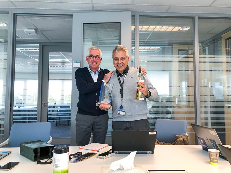
Javier Benedicto (left) and Giuliano Gatti. (Photo: ESA)
Javier Benedicto, head of the Galileo Programme and Navigation-related Activities at the European Space Agency, accepted the 2018 Satellites Leadership Award and delivered these remarks on behalf of Giuliano Gatti at the 2018 GPS World Leadership Awards Ceremony. Gatti, the space segment procurement manager at the European Space Agency, received the award for his contribution to setting up the Galileo constellation from GIOVE-A and -B precursors through all Galileo operational satellites: Soyuz and Ariane 5 launches, a total of 26 Galileo satellites deployed in 7 years.
On behalf of Giuliano Gatti, I express his gratitude for this award.
After a 20-year career in microwave equipment for satellite application, working in Italy, Canada and the Netherlands, Mr. Gatti started working on navigation satellites at end of the 1990s as ESA Galileo Space Segment Manager.
He went through the initial difficulties of the program, namely the uncertainty on financing and the technical lack of maturity of critical units such as atomic clocks. At the time, joining the Galileo team of the European Space Agency was risky and challenging.
In spite of these issues, he was a key player in the developments of the first two Galileo experimental satellites, GIOVE-A and GIOVE-B, and he was in charge of their launches in 2005 and 2008, respectively, on Soyuz rockets from Baikonour, Kazakhstan.
He then followed the development and launch of the 4 IOV satellites, two in 2011 and two in 2012, from the European space port in French Guyana, on a Europeanized version of the Soyuz rockets. The first IOV launch was actually the first launch with this version of the launcher, and interface and schedule coordination issues were challenging tasks for him.
He then was instrumental for the procurement of the following generation of satellites, the 22 FOC satellites. He struggled to make sure that satellites would be produced and launched in line with the program deployment plan. Another challenge in this phase was ensuring that the adaptation of the Ariane-5 ES rocket to the Galileo satellites would converge in time and comply with all technical requirements.
Under his guidance and responsibility, the 22 satellites were put in orbit with 5 Soyuz launches and 3 Ariane-5 launches. Here the most difficult event was the launch that put two Galileo satellites in the wrong orbit, and the subsequent recovery of the satellite mission. In addition, a number of failures affected some of the in-orbit atomic clocks, and hedrove the investigation that led to the discovery of the root causes and their resolution.
Mr. Gatti then initiated the procurement and production of the follow-up recurring satellites, the so-called Batch-3 satellites. These 12 satellites have stringent schedule requirements and their first launch is planned for late 2020 or early 2021.
In parallel, he contributed to the definition of the next generation of satellites, the Transition Satellites: heavier spacecraft with improved performance and high level of re-configurability and flexibility. They will be the first step moving from the existing first generation of satellites to the second generation. In this phase, his experience and competence have played a fundamental role to arrive at the definition of the appropriate procurement requirements.
After 20 years on the development and deployment of Galileo, being in charge of the launches of 28 satellites, from the first GIOVE-A satellite in 2005 to the launch of the last 4 FOC satellites in July 2018, Mr Gatti will retire in mid-2019.
He is delighted and honored that all his efforts and contributions to develop and launch the Galileo constellation have been recognized in this important GNSS event.
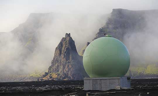
Global satellite navigation systems are continuously bathing Earth in satnav signals. As well as helping in our daily lives, these signals are also tools for cutting-edge science. A new ESA facility, based at ESA’s astronomy centre near Madrid, is championing their use for everything from Earth monitoring to fundamental physics.
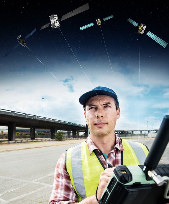
A Surveyor uses a GNSS device to map urban assets with Galileo and EGNOS. (Image: ESA)
The new ESA Global Navigation Satellite Systems (GNSS) Science Support Centre is based at ESA’s European Space Astronomy Centre, ESAC, near Madrid. Run by ESA’s Galileo Science Office, the GSSC integrates IT and satnav infrastructure to deliver advanced data processing services to the scientific community.
Precisely timed to a few billionths of a second and highly stable, satnav signals can be used as a point of reference for many scientific sectors, including Earth and atmospheric sciences, astronomy, highly precise timing metrology as well as the study of relativity and other fundamental physics topics.
Current satnav infrastructure plans worldwide should see more than 120 satnav satellites in orbit in coming years. This number includes Europe’s own Galileo constellation — offering unique features such as its highly stable passive hydrogen maser atomic clocks, multiple transmission frequencies, robust modulation, wide bandwidth and onboard laser retro-reflectors, which permit exact pinpointing of the satellites’ position in space down to a few tens of centimetres.
“The potential of satnav for science has been recognised for a long time,” explains Javier Ventura-Traveset, Head of ESA’s Galileo Science Office. “The Galileo Science Office was set up in 2016 as a joint initiative between ESA’s Science and Navigation Directorates, coordinating scientific opportunities through interaction with the scientific community and the independent GNSS Science Advisory Committee.
“The opening of the new centre is the next step. It is ESA’s concrete answer to the need expressed by the scientific community for a one-stop-shop to offer researchers long-term GNSS data, products information, results of scientific experiments, plus services to enhance GNSS scientific research and collaboration.
“The future evolution of the centre will be driven by the interaction and feedback received from the scientific community, maximizing synergies with other GNSS data service providers from other institutions and research organization.”
Among the activities to be supported by the new GSSC are big data processing of large amounts of satnav data, crowdsourcing as a means of weather monitoring and a scientific assessment of satnav performance in Antarctica.
It also supports the continuing measurements of general relativity using Galileo satellites 5 and 6 and serves as a global data centre for the International GNSS Service. The long-established Navipedia website, giving technical information on satnav, is also hosted by the GSCC.
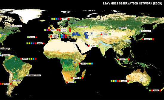
One enthusiastic early adopter is ESA’s Navigation Support Office, based at ESA’s ESOC mission control centre in Darmstadt, Germany, lending support to mission teams making use of satnav to steer satellites.
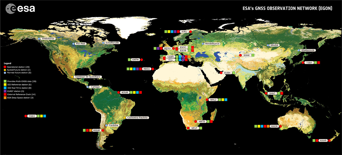
“The GSSC is a welcome addition to ESA’s activities in the science of satellite navigation,” says Werner Enderle, heading ESOC’s Navigation Support Office. “The GSSC already hosts GNSS products generated by the team at ESOC, including observations from our worldwide EGON GNSS Observation Network and precise satellite orbits generated by their state-of-the-art software. Our two teams look forward to this collaboration continuing for the benefit of ESA and the scientific community.”
The GSSC will roll out access to data, products and services over the coming months.
By Paolo Crosta, Paolo Zoccarato, Rafael Lucas and Gerarda De Pasquale, European Space Agency
Test set-up. (Image: Authors)
Most mass-market manufacturers have already developed a dual-frequency chip or will soon do so. What is still not completely clear is the main benefit of adding the second frequency. Is it beneficial just for correcting ionospheric error?
Will it provide an improvement of the ranging error thanks to the wideband nature of the signal broadcast on the second frequency and their multipath rejection capabilities? Is it improving the measurement quality by means of a higher transmitting power?
Could it be exploited as a source of data for the provision of accurate orbit and clock corrections? What is the best PVT algorithm to apply to a multi-constellation dual-frequency mass-market chip?
To answer these questions, an evaluation kit of the Broadcom chip BCM4775 has been tested — the first dual-frequency mass-market chip commercially available.
Results show:
the code noise (multipath) is often the main source of error, hiding the benefits of more accurate clocks and orbital data.
wide-band signals are very beneficial for multipath rejection. Position fix based on E5a-L5-only measurements even with fewer satellites can outperform L1-E1-only in tests performed this September (impact of the new Galileo satellites).
after deactivation of the duty-cycle tracking on Android phones, the carrier phase measurements are improved and we do not experience any longer filter resets in the position Kalman filter.
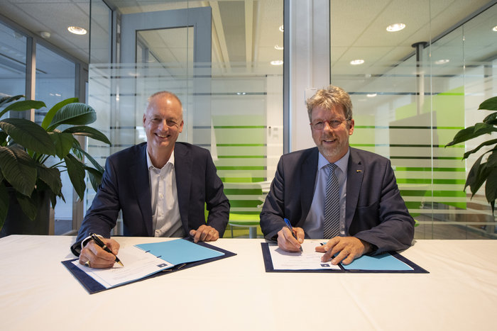
The European Space Agency has awarded a new framework contract and two new work orders to Thales Alenia Space in France to upgrade the Galileo Mission Segment, the element of the worldwide Galileo ground segment dedicated to delivering navigation services. Included are upgrades to the Galileo Security Monitoring Centre (GSMC) near Paris, and implementation of a second GSMC in Spain, near Madrid.
ESA Director of Navigation Paul Verhoef signed the contract with Thales Alenia Space Senior Vice President of Sales Martin van Schaik on Oct. 17 at ESA’s ESTEC technical centre in Noordwijk, the Netherlands.
“Galileo has already proven to be the highest performing satellite navigation system in the world, even before the constellation is complete,” Verhoef said. “This achievement is the result of the close collaboration between the public sector — the European Commission, the European GNSS Agency and ESA — and our industrial partners throughout Europe.
Contract signing: van Schaik (left) and Verhoef. (Photo: ESA)
“Today I am very happy to announce a continued relationship with Thales Alenia Space in one of the most complex parts of the system, namely the Ground Mission Segment, and thank them for their commitment to the programme.”
The constellation in orbit is only one element of the overall satellite navigation system – the tip of the Galileo iceberg. At the same time as the satellites were being built, tested and launched, a global ground segment was put in place.
Complex System
Establishing Galileo’s ground segment was among the most complex developments ever undertaken by ESA, having to fulfil strict levels of performance, security and safety.
In 2017, responsibility for operating the Galileo ground segment was passed to ESA’s partner organization, the European GNSS Agency (GSA). Nevertheless, ESA continues to be in charge of the maintenance, development and evolution of the ground segment, as well as the development of the space segment.
GSMC upgrade and construction. The first work order contracts Thales Alenia Space as prime contractor to undertake all necessary activities to upgrade the Galileo Mission Segment and the GSMC as part of Galileo’s exploitation phase.
This work includes upgrading Galileo’s system architecture to provide more accurate navigation products for broadcast by Galileo satellites, updating obsolescent elements in the current system, and improving operability linked to the provision of services and enhanced robustness.
This work order also includes the construction of additional uplink stations – tasked with uplinking the latest navigation messages to the Galileo constellation — at the existing Galileo ground station sites of Papeete in French Polynesia and Svalbard in Norway.
A new sensor station — providing a ground-based measurement of Galileo signal quality and precise satellite position — will also be installed at Wallis Island in the Pacific.
Galileo’s Nouméa ground station’s Sensor Station and Uplink Station. (Photo: ESA)
The work order will also augment the capabilities for implementation of the Public Regulated Service (PRS), the single most accurate and secure class of Galileo signals. Encrypted PRS signals will be made available only to authorised governmental users through approved national authorities.
Together, the two GSMCs will ensure the security of the overall Galileo system and manage PRS access and operations.
Security monitoring. The second work order contracts Thales Alenia Space as prime contractor to implement security monitoring functions for Galileo operational assets — including the control centres, service facilities and ground stations.
The integration, qualification, deployment and migration into operational services of the various upgraded segments will be undertaken over the next three years.
ESA has issued these work orders in its role of undertaking the design and development of future upgrades and the technical development of infrastructure as well as overseeing Galileo’s deployment, on behalf of the European Union, Galileo’s owner.