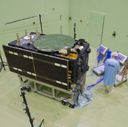
There might seem to be a hole in the side of this Galileo satellite — in fact its folded solar wings are simply reflecting a noise horn in the wall, about to recreate the deafening roar of a rocket lifting off.
Anyone witnessing a rocket launch will be struck by the noise levels, even when observing from several kilometres away. A satellite on top of its launcher is exposed to much higher levels, of course. So testing is essential to ensure that the satellite structure can withstand such a sustained loud sound.
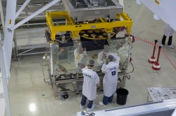
This first Galileo Full Operational Capability (FOC) satellite, successor to the four Galileo navigation satellites already in orbit, underwent acoustic testing in July, part of a full-scale test campaign taking place at ESA’s ESTEC Test Centre in Noordwijk, the Netherlands.
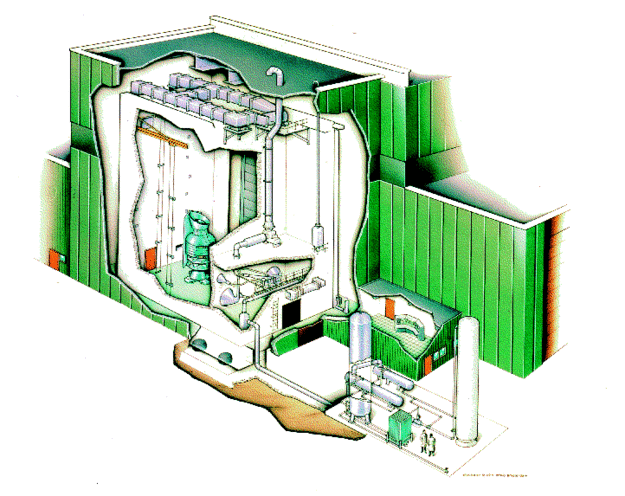
The satellite was placed in the Large European Acoustic Facility, LEAF, effectively the largest sound system in Europe. A quartet of noise horns are embedded in one wall of this 11 m wide by 9 m deep and 16.4 m high test chamber.
Noise is generated by passing a carefully modulated flow of gaseous nitrogen through the horns, following the predetermined test profile — this inert gas selected to avoid any contamination of any delicate onboard systems, the satellite having been placed in flight configuration for the purpose of the test.
“The acoustic noise level reached during the test was 140.7 decibels, about the same noise as standing 25 m away from a jet taking off,” explained Georg Deutsch of European Test Services, the company operating the Test Centre for ESA.
“This involved a maximum liquid nitrogen flow in this case of 3.5–4 kg per second. Liquid nitrogen delivered by tanker is vaporised to pass through the horns. More or less, we were able to finish this test campaign with one full tank of liquid nitrogen — about 18.5 tons.”
Galileo in flight configuration for acoustic testing.
Once the massive door of the LEAF is closed, its 0.5 m-thick steel-reinforced concrete walls serve to safely contain the sound. These are coated in turn with thick epoxy resin whose reflectivity increases internal reverberation.
The chamber itself is supported on rubber bearing pads to isolate it from its surroundings.
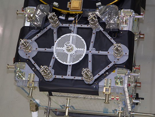
The Galileo satellite itself was similarly isolated — its support structure being borne on air-based “vibration isolators” to make sure any vibration that ensues is due to direct acoustic noise as opposed to resonance from the ground.
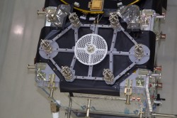
The satellite had to be fitted with dozens of accelerometers to detect internal vibration — large items such as batteries are most prone. The blue cables shown relay accelerometer data. It was also surrounded with microphones to check the acoustic noise around the satellite followed the planned profile, providing around 250 data channels in all.
This second FOC satellite arrived at ESTEC on 9 August from manufacturer OHB in Bremen, Germany.
A total of 14 FOC satellites are being produced as part of the first work order for Galileo FOC, which will involve a continuous round of testing at ESTEC as an integral part of their path to orbit. A second work order of eight satellites has been also released to OHB and their production will follow the production of the first batch.
LEAF.
This first Galileo FOC satellite has since had its delicate solar wings removed as part of its preparation for ‘thermal vacuum’ testing. It will stay in a vacuum chamber for weeks on end and be subjected to the same temperature extremes it will experience in orbit.
Once unboxed, the second FOC satellite will undergo a similar acoustic testing and then a System Compatibility Test Campaign
will be performed, linking it up with the Galileo Control Centres in Germany and Italy and ground user receivers as if it was already in orbit.
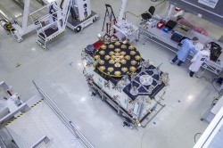
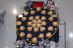
The European Space Agency (ESA) has released detailed views of the next batch of Galileo satellites, the first of which cuurently performs under simulated space conditions at the ESTEC technical center in Noordwijk, the Netherlands.
The first Galileo Full Operational Capability (FOC) satellite is functionally identical to the four Galileo In-Orbit Validation satellites already in orbit, but has been built by a separate industrial team. All 22 FOC satellites so far procured by ESA have as prime contractor OHB in Bremen, Germany; Surrey Satellite Technology Ltd. in Guildford, UK, produces the navigation payloads. The photos shown here were taken at OHB.
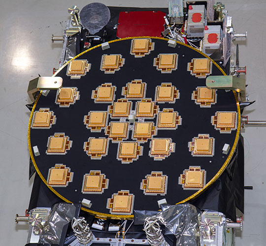
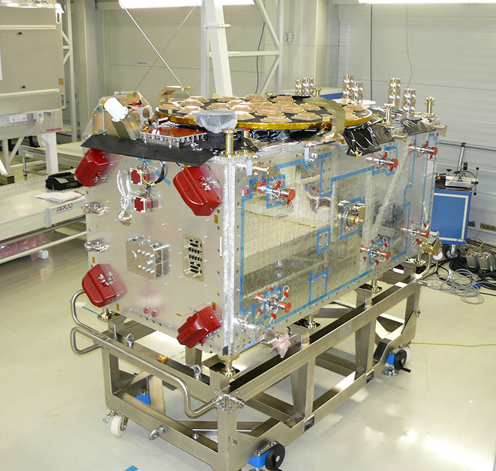
The satellite’s body measures 2.5 x 1.2 x 1.1 meters (8.2 x 3.9 x 3.6 feet), and it weighs approximately 733 kilos (1,616 pounds). Atop it in these photographs (although on the underside when orbiting Earth) is the circular L-band antenna that will continuously broadcast navigation messages.
The smaller, hexagonal antenna beside it will pick up emergency messages from vessels in distress and relay location and other information to search and rescue authorities, contributing to the international Cospas–Sarsat system.
A second Galileo FOC satellite is due to also travel to ESTEC this summer, preparing for a launch later this year.
L-Band antenna of the FOC satellite. Photo: ESAemergency signal antenna of the FOC satellite. Photo: ESA
L2, L5 CNAV Testing
The U.S. Air Force Space Command began testing civil navigation (CNAV)capabilities on the GPS L2 and L5 signals on June 15 and was scheduled to continue until June 29. Civil users and manufacturers were invited to participate.
According to the GPS Directorate, the CNAV live-sky testing program will span several years and will evolve to support GPS enterprise and modernized civil navigation performance objectives. Objectives include:
◾ Verify and validate the CNAV requirements specified IS-GPS-200F and IS-GPS-705B.
◾ Facilitate the development of robust IS-compliant L2C and L5 civil receivers.
More information about the testing is available in a 52-page PDF, including sections on test strategy, event conditions and constraints, operational environment, test support resources and data collection, evaluation methodology, risk assessment, and reporting.
The L2 CNAV data is an upgraded version of the original NAV navigation message. It contains higher precision representation and nominally more accurate data than the NAV data. Two out of every four packets are ephemeris data and at least one of every four packets will include clock data, but the design allows for a wide variety of packets to be transmitted. Only a fraction of the available packet types have been defined; this enables the system to grow and incorporate advances.
One packet contains a GPS-to-GNSS time offset, enabling interoperability with other global time-transfer systems such as Galileo and GLONASS, both of which are supported. The extra bandwidth enables the inclusion of a packet for differential correction. Every packet contains an alert flag, to be set if the satellite data cannot be trusted. Users will know within six seconds if a satellite is no longer usable, important data for safety-of-life applications such as aviation.
The system is designed to support 63 satellites, compared with 32 in the L1 NAV message.
Possible New GPS Launch Option
The U.S. Air Force Space and Missile Systems Center (SMC) has signed a Cooperative Research and Development Agreement with Space Exploration Technologies Corp., better known as SpaceX, as part of the company’s effort to certify its Falcon 9 v1.1 Launch System for National Security Space (NSS) missions.
SMC and SpaceX will look at the Falcon’s flight history, vehicle design, reliability, safety systems, and other aspects. Once the evaluation is complete, the SMC commander will determine whether SpaceX has the capability to successfully launch NSS missions using the Falcon 9 v1.1.
Currently, United Launch Alliance’s Delta IV and Atlas V are the only certified launch vehicles capable of lifting NSS payloads — such as the GPS satellites — into orbit. The addition of multiple certified launch vehicles provides more options to place needed capabilities on orbit. While certification does not guarantee a contract award, it does enable a company to compete for launch contracts. Those contracts could be awarded as early as Fiscal Year 2015 with launch services provided as early as FY 2017.
GPS III Funds Cut, GPS IV on Horizon?
According to a U.S. Department of Defense (DoD) spending plan released on June 1, space programs were relatively protected in an environment of across-the-board budget cuts known as sequestration. Specifically, although the budget for GPS III has been reduced for both 2013 and 2014, the reductions still allow the proposed program to stay on course. The cuts amount to about $58 million from GPS III and its associated ground system.
Congressional lawmakers proposed spending $77 million less next year for the GPS III satellite and ground systems than proposed by the Air Force, which asked for nearly $1.1 billion.
Currently, the Air Force has eight GPS III satellites contracted with Lockheed Martin Space Systems, and current plans call for the purchase of 12 further satellites with improved capabilities.
GPS IV. Gen. William Shelton, commander of Air Force Space Command, floated the possibility of a new look for the constellation on Capitol Hill. In an April 25 House hearing, Shelton said the Air Force will study this fall whether to buy another 12 GPS III craft or move on to a new generation of satellites.
“Would it be better to continue [GPS III] as opposed to starting a whole new fourth generation?” asked Representative Doug Lamborn of Colorado. “That’s the decision we will have to make in the fall,” replied Shelton. “It seems like the answer would be ‘yes’ but we will study that.”
A key aspect of the next-next gen satellite would have to be dual-launch capability. The reduction in expense this would furnish is in higher and higher demand as time goes by. Both Lockheed and Boeing are reportedly in talks with the Air Force regarding IV.
System Briefs
GLONASS Embezzle Imbroglio. The Russian Federal Security Service is investigating the embezzlement of billions of rubles from the construction of the GLONASS center in Korolyov, a town outside Moscow, as reported by Izvestia.
Construction of the GLONASS control and support center began in June 2010 on the site used by TsNIImash, the head research company of Russia’s federal space agency. The center was supposed to hold equipment for collecting and processing the data supplied by the GLONASS global network.
The construction was financed by a federal program, with 1.050 billion ($33.22 million) allocated for the project. By the end of 2010, it came to light that construction costs had been overstated, Izvestia reports. An expert appraisal revealed that the contractor had rigged the costs. The government did not allocate additional funds, so construction was suspended in December 2011 when the Federal GLONASS Program for 2002-–2011 ended. The construction of the building has never been completed.
In November 2012, the general designer of GLONASS, Yuri Urlichich, was dismissed from his post as a result of the scandal.
IRNSS Nav Center, July Launch. The Indian Space Research Organization (ISRO) Navigation Centre for the Indian Regional Navigation Satellite System (IRNSS) was inaugurated May 28, at the Deep Space Network complex at Byalalu, near Bangalore, India.
IRNSS, an independent navigation satellite system being developed by India, will have a constellation of seven satellites in geostationary and inclined geosynchronous orbits. IRNSS coverage will extend over India and the southeast Asia region. The ISRO Navigation Centre (INC) is responsible for providing the time reference, generation of navigation messages, and monitoring and control of ground facilities including ranging stations of IRNSS. IRNSS will establish a network of 21 ranging stations geographically distributed primarily across India to provide data for the orbit determination of IRNSS satellites and monitoring of the navigation signals.
On June 15, India’s Economic Times reported that a new launch date (postponed from previously announced June 11) was set for IRNSS-R1A or 1A, the first IRNSS satellite: July 1 at 18:13 UTC.
Beidou Jammed. A Beidou satellite is now believed to have experienced interference from a complex electromagnetic environment, which cut off signal transmissions in 2007, China’s People’s Daily reported. A team of scientists was able to overcome the interference issue in less than three months by 2008.
Wang Feixue, a scientist specializing in the Beidou navigation system and a senior colonel in the People’s Liberation Army said, “Had they not been able to recover the signal within three months, future satellite launches would have been indefinitely delayed. And satellites already launched would have been put out of operation.”
EGNOS Contract. A new European Geostationary Navigation Overlay Service (EGNOS) service provision contract was signed June 26 at the European Commission Vice President Antonio Tajani’s office in Brussels. The contractee is again the European Satellite Services Provider (ESSP), founded in 2001and in 2008 transformed into ESSP SAS and moved from Brussels to Toulouse.
Its shareholders are seven European air navigation service providers: Aeropuertos Espanoles y Navegacion Aerea (Spain), Deutsche Flugsicherung GmbH (Germany), Direction générale de l’Aviation civile (France), Ente Nazionale Di Assistenza Al Volo (Italy), National Air Traffic Services (UK), Navegação Aérea de Portugal, and Skyguide (Switzerland).
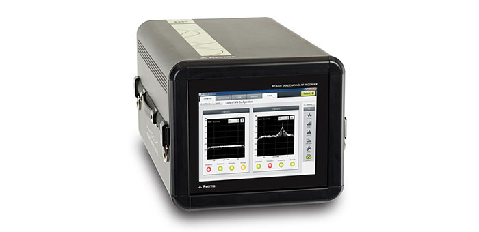
Averna, developer of test solutions and services for communications and electronics device makers worldwide, announced today that the European Space Agency (ESA) has selected Averna’s Record & Playback solution for signal analysis and monitoring of Galileo satellites.
The R&P platform selected by ESA features the RP-5300, a compact 2-channel wideband RF recorder designed to record live RF signals in the field, and the URT-2200 RF Player for GNSS. Averna’s R&P solution is powered by RF Studio, a high-performance RF recorder and playback software specifically designed for RF designers and researchers, to facilitate recording, analysis and storage of RF signals.
The Averna RP-5300 RF Recorder is specifically adapted for all GNSS applications, including Galileo, GPS, GLONASS, and Compass (BeiDou-2). The system has two 50-MHz wide channels that can be tuned on any frequencies from 330 MHz to 2500 MHz. To address the many synchronization and coherency challenges of GNSS testing, Averna has developed a proprietary software/hardware architecture that allows control and tight synchronization between multiple recording channels and systems under the 1 nanosecond (ns) level.
“Averna’s RP-5300 is the leading commercial product offering two 50-MHz wide channels that can capture such a wide range of real-world RF signals, complete with the interference and general degradation that end-users will experience. Two units can even be interconnected to enable a 4-channel, phase-coherent synchronized recorder,” commented Brendan Wolfe, director of Market Development for Averna. “The ESA is using the latest technology available and we are thrilled that our products have been chosen for this important undertaking.”
“Averna’s advanced record-and-playback systems support our pressing needs for long and extensive data-collection campaigns in the field,” said M. Crisci, Head of the Radio Navigation Systems and Techniques Section at the European Space Agency. “Averna’s R&P solution enables us to record multiple wideband signals at the same time, over a wide frequency range, and then replay the signals repeatedly. As receivers become more and more sophisticated, it is imperative that real-world signals and conditions be recreated for thorough validation and testing.”
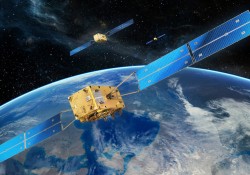
Galileo is Europe’s program for a global navigation satellite system (GNSS), providing a highly accurate, guaranteed global positioning service, interoperable with the U.S. GPS and Russian GLONASS systems. It currently has four satellites in service and upon completion it will consist of 30 satellites and ground infrastructure. The Galileo system is a collaboration between the European Union and the ESA.
The European Space Agency (ESA) has released a series of photos providing the first detailed views of the next batch of Galileo satellites, the first of which has already been delivered to ESA for rigorous testing in simulated space conditions. Scroll down to see the photos.
The first Galileo Full Operational Capability (FOC) satellite was delivered to ESA’s ESTEC technical centre in Noordwijk, the Netherlands, on May 15. It is being prepared for testing in the ESTEC Test Centre, a unique facility for Europe with all the facilities needed to validate a satellite for launch under one roof.
This initial FOC satellite is functionally identical to the first four Galileo In-Orbit Validation satellites already in orbit, the operational nucleus of the full Galileo constellation, but has been built by a separate industrial team.
Like all the other 21 FOC satellites so far procured by ESA, the satellite’s prime contractor is OHB in Bremen, Germany, and the navigation payload was produced by Surrey Satellite Technology Ltd. in Guildford, UK. The photos shown here were taken at OHB.
The satellite is approximately the size and shape of an old-fashioned telephone booth, dominated by its circular L-band antenna that will continuously broadcast navigation messages down to Earth.
The smaller, hexagonal antenna beside it will perform a no less vital task — picking up emergency messages from vessels in distress to relay to search and rescue authorities, contributing to the international Cospas–Sarsat system.
A second Galileo FOC satellite is due to join its predecessor at ESTEC later this summer, preparing for a launch scheduled for later this year.
Galileo FOC: These pictures give the first detailed views of the next batch of Galileo satellites, the first of which has already been delivered to ESA for rigorous testing in simulated space conditions. Credit: OHB
Galileo FOC main antenna: Galileo FOC is dominated by its circular L-band antenna that will continuously broadcast navigation messages down to Earth. Credit: OHB
The Galileo FOC satellite is approximately the size and shape of an old-fashioned telephone booth, similar to the preceding IOV design. Credit: OHB
Galileo FOC search and rescue antenna: Galileo’s smaller, hexagonal antenna beside its main navigation antenna is designed to pick up emergency messages from vessels in distress to relay to search and rescue authorities, contributing to the international Cospas–Sarsat system. Credit: OHB
Gaileo Full Operational Capability satellites in orbit – the second batch of Galileo satellites. These FOC satellites follow on from the initial four Galileo In-Orbit Validation satellites, the first two of which went into orbit on 21 October 2011 with the remaining two joining them on 12 October 2012. As prime contractor for the FOC satellites, OHB is responsible for developing the satellite platform and integrating the satellite with its payload – the part of the satellite that provides Galileo’s precision positioning measurements and services to users worldwide – developed at Surrey Satellite Technology Ltd in Guildford, UK (also providing assistance to OHB with final satellite assembly). Credit: OHB
Galileo FOC satellite does same work as the IOV predecessor. The ‘business end’ of the Galileo FOC satellite hosts the L-band navigation antenna and the smaller search and rescue antenna on the same face. This initial FOC satellite is functionally identical to the first four Galileo In-Orbit Validation satellites already in orbit, the operational nucleus of the full Galileo constellation, but has been built by a separate industrial team. Like all the other 21 FOC satellites so far procured by ESA, the satellite’s prime contractor is OHB in Bremen, Germany and the navigation payload was produced by Surrey Satellite Technology Ltd in Guildford, UK. Credit: OHB
The fourth International Colloquium on Scientific and Fundamental Aspects of the Galileo Programme will be held in Prague, Czech Republic, December 4–6.
Since 2007, the worldwide scientific community has met every two years to discuss the possibilities for boosting the scientific use of Galileo and for contributing to the development of the GNSS.
The event is always organized in one of the 20 European Space Agency’s Member States, and makes an essential contribution to ESA’s implementation and definition of the evolution of the European GNSS. The gathering of major academic players provides a scientific reference for institutional executives and industry, as well as offering a unique platform for promoting innovative GNSS initiatives at large.
The colloquium focuses on four major areas of research:
Scientific applications in meteorology, geodesy, geophysics, space physics, oceanography, land surface and ecosystem studies, using either direct or reflected signals, differential measurements, phase measurements, radio occultation measurements, using receivers placed on the ground, in aircraft or on satellites.
Scientific developments in physics, dealing with future GNSS, particularly in testing fundamental laws in astronomy and in quantum communication. Relativistic reference frames and relativistic positioning will be addressed.
Aspects of metrology such as reference frames, onboard and ground clocks, and precise orbit determination.
Scientific aspects of satellite navigation and positioning such as signal propagation, tropospheric and ionospheric corrections and the means to model and mitigate multipath and interference.
The various possibilities to use navigation satellites such as Galileo for scientific purposes will be reviewed and the use of scientific applications to contribute to make the most of the present systems and define their evolution will be scrutinized.
The conference is being organized as a series of plenary talks and two parallel half-day sessions.
Online submission of abstracts is open until June 14 through the colloquium website, where other detailed information is also available.
In the early hours of May 15, Galileo’s first full operational capability (FOC) satellite left the manufacturer’s integration hall in Bremen, Germany. The satellite, assembled by OHB System AG, is now headed for Noordwijk in the Netherlands, where it will undergo an environmental testing campaign and further system testing at the ESTEC’s Test Center on the premises of the European Space Agency (ESA).
Before the satellite was shipped, it had successfully completed integration and system testing, according to OHB System.
The first Galileo FOC satellite. (Photo credit: OHB System AG.)
Its twin FOC satellite is in the final phase of completion at OHB System. Over the next few weeks, it will also be integrated and tested, after which it will be shipped to Noordwijk. The two satellites are to be placed in orbit on board a Soyuz launcher, which will is planned to lift off from Kourou in French Guyana this fall.
These two satellites are the first of a series of 22 Galileo FOC satellites manufactured by OHB System and its industrial partners. The FOC phase of the Galileo program is managed and funded by the European Union. The European Commission and ESA have signed a delegation agreement by which ESA acts as design and procurement agent on behalf of the commission.
At ESA’s test center, thermal vacuum testing will simulate the temperature extremes the satellites must endure in the airlessness of space throughout their 12-year working lifetimes. Without any moderating atmosphere, temperatures can shift hundreds of degrees from sunlight to shadow.
Other activities on the schedule include shaker and acoustic noise testing — simulating the vibration and noise of launch — as well as electromagnetic compatibility and antenna testing, placing the satellite in chambers shielded from all external radio signals to reproduce infinite space and check that its various antennas and electrical systems are interoperable without harmful interference.
Each satellite will offer the full range of Galileo positioning, navigation and timing services, plus search and rescue message relays, their accuracy ensured by on-board atomic clocks kept synchronized by a worldwide ground network.
“The Galileo FOC satellites provide the same capabilities as the previous IOV satellites, but with improved performance, such as higher transmit power,” explained Giuliano Gatti, head of the Galileo Space Segment Procurement Office. “They are to all intents a new design that requires a full checkout before getting the green light for launch. By fully validating this satellite, the second flight model due to follow it here at beginning of June, and the third one due to arrive in ESTEC at middle of July, we gain full knowledge of their characteristics, and the further satellites in the series will require less rigorous functional testing.”
Report from ENC: Constellation Needs 22 Satellites in Three Years
Launch, deploy, and operate “22 satellites in less than 3 years.” That’s two satellites every three months, leading to a four-at-once launch in 2014. And that’s the challenge that Europe and the European Space Agency (ESA) now face.
This pointed call to action during the opening plenary of the European Navigation Conference (ENC) came from Didier Faivre, director of Galileo Programme and Navigation Related Activities at ESA. It was the only somber note sounded during the keynote speeches, which otherwise paraded the stirring recent accomplishments of the Galileo In-Orbit Validation (IOV) phase. IOV now concludes, and Galileo’s operational phase opens.
The ENC takes place in Vienna, Austria this week (April 23–25), hosted by the Austrian Institute of Navigation. Privately and informally, a handful of knowledgeable conference attendees expressed confidence that OHB System can furnish the completed satellites, at least, according to schedule. OHB System is the prime contractor for construction of 22 Full Operational Capability (FOC) Galileo satellites and is responsible for developing the satellite bus and for integrating the satellites. Surrey Satellite Technology Ltd. (SSTL) is developing and constructing the navigation payload and assisting OHB with final satellite assembly.
“Using only European tools and means, European ground infrastructure deployed on European territory, our conception, machine and design, is totally validated,” stated Faivre, referring to the recent Galileo-only positioning fix by ESA. The March 12, 2013, event marks “the end of the beginning,” and culminates 12 years of intense work at all levels of European industry.
“Europe is at par with GPS” with performance as expected. “I hope that soon our U.S. colleagues will be jealous of our performance,” Faivre stated, implying yet again the persistent Galileo claim that the system will be more accurate than GPS. He returned to this theme with reference to Fugro’s accomplishment of real-time precise point positioning at the centimeter level.
He acknowledged that “It’s a technological competition with the United States, Russia, and China,” even though all may be friendly and collegial.
In that competitive light, “the success of Galileo will be measured by the number of users,” and not by the number of satellites, or the degree of accuracy, or the strength of the signal.
Previously, the ENC audience had heard from Ingolf Schädler that “Europe has closed the gap with the technological superpowers,” in what “may be the most complex invention ever of mankind, the system of navigation that is GNSS.” He also made a proud reference to Austrian-produced signal generators aboard Galileo’s orbiting IOV satellites. Schädler is the deputy director general of innovation for the Austrian federal Ministry for Transport, Innovation and Technology.
“We have reached cruising speed,” announced the third keynote speaker, Carlo des Dorides of the European GNSS Agency (GSA). He was referring explicitly to the re-positioning of the GSA headquarters from Brussels to Prague, but the remarks reverberated to the Galileo program as a whole.
David Blanchard, deputy head of unit, EU Satellite Navigation Programmes for the European Commission, quoted an unnamed U.S. publication: “With the capability to make a position fix from four signal-broadcasting satellites, we can now say that Galileo has truly arrived.”
That statement appeared in the May 2013 GPS World, an issue of the magazine that was distributed in conference bags to all attendees at the ENC.
Blanchard then shifted the focus slightly from Galileo, to Galileo together with the European Geostationary Navigation Overlay Service (EGNOS), Europe’s satellite-based augmentation service that also broadcasts GPS corrections. “We have to make sure that all the capabilities afforded by EGNOS are realized.” He also made strong references to the EGNOS Data Access Service (EDAS).
Blanchard cited a current ongoing study that shows that 6 to 7 percent of European gross domestic product (GDP) is dependent upon GNSS.
“A gold mine within arm’s reach of European industry” was how Gard Ueland, head of Galileo Services, characterized the present situation. “Development of European downstream market is crucial; it also has to bring more benefits to European society.” Galileo Services will host a workshop of industry stakeholders in late October, at the OHB System premises in Bremen, Germany. Watch GPS World Events calendar and news for an announcement with specific dates.
Having attained altitude and cruising speed, the Galileo program must now shift to warp speed to hit its goals on time: 18 satellites in orbit by the end of 2014, and a total of 26 by the end of 2015. Early services by the end of 2014, and full services in 2016. Stable, continuous services, as Blanchard emphasized.
The radio spectrum is about to get even busier, as Europe’s Galileo satnav system starts services, at the same time the European Space Agency (ESA) tests novel satellite-based telecommunication services. Supporting these developments from the ground, ESA’s new custom-built Telecommunications and Navigation Testbed Vehicle will measure the resulting signals from all over Europe.
Adapted from a Mercedes Benz Sprinter van, this unique measurement vehicle has been delivered to ESTEC by Austria’s Joanneum Research institute. “This is a dual-purpose vehicle, suitable for both telecommunications and navigation system testing,” explained Simon Johns of ESA’s Radionavigation Systems and Techniques Section.
“For navigation, we have the Galileo constellation coming on stream, as well as the stepping up of ESA’s GNSS Evolution programme — designing what comes next after Galileo’s first generation.”
The four wheel-drive vehicle can host a three-person team, and is crammed with dedicated navigation and telecommunication monitoring equipment.
Testbed vehicle screen.
“One of the main goals driving the design was to have an ‘easy to adapt’ test platform suitable to set up test campaigns for different mobile satellite systems and standards that would require different types of antennas and specific receiver/transmit equipment,” explained Olivier Smeyers of ESA’s Communication-TT&C Systems and Techniques Section.
“On the telecommunications side, there is a continuous effort to enhance current and create new mobile satellite-based broadcast and interactive services via the evolution of current systems or developing new standards,” Smeyers said. “Testing in the field is an essential element for validating and eventually establishing evolved or new standards. The vehicle has built-in multimedia equipment, including storage and control computers, multimedia gateway, passenger LCD screens, cameras and microphones, to serve this purpose.”
The vehicle features include two removable roof plates to mount specialized antennas (one currently hosts the antenna of a Broadband Global Area Network satellite terminal for Internet connectivity and multimedia and data streaming), an 8-meter-high telescopic mast capable of carrying 25 kilograms, a rubidium atomic clock synchronized to GPS time with nanosecond accuracy, a high-end spectrum analyzer and oscilloscope for signal measurements, and mobile temperature sensors to monitor the rack equipment.
A fish-eye video camera incorporating onscreen GPS timing and positioning performs continuous recording of its surroundings — to throw light on high buildings, trees, or other factors that might affect results.
Internal and external generators yield up to 5 kilowatts to keep everything running — sufficient power to supply two typical European households.
“The challenge was to fit in all the equipment and provide the necessary power and air conditioning, while still weighing less than 3.5 tonnes,” said Thomas Prechtl of Joanneum Research. “Exceeding this weight would have meant drivers would have needed a special license, and potentially limited its operations in some European nations.”
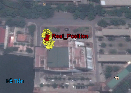
Scientists in Hanoi, Vietnam, send word that on March 27 the four Galileo in-orbit validation satellites were visible at the same time in the sky over that Southeast Asian country for nearly two hours (from 2:15 to 4:00 GMT) while transmitting a valid navigation message.The research team of the NAVIS Centre at Hanoi University of Science and Technology (HUST) successfully computed what they claim is the first Galileo-only position fix in Asia.
Figure 1 depicts the obtained positions are depicted on top of the roof of the NAVIS Centre, where the antenna used to receive the signals is located (latitude = 21°00’16.69” N, Longitude = 105°50’37.90” E, height = 35,2 meters).
Figure 1. Positions obtained by only Galileo E1 Open Service (the antenna is located at the roof of the Ta Quang Buu library building inside HUST campus)
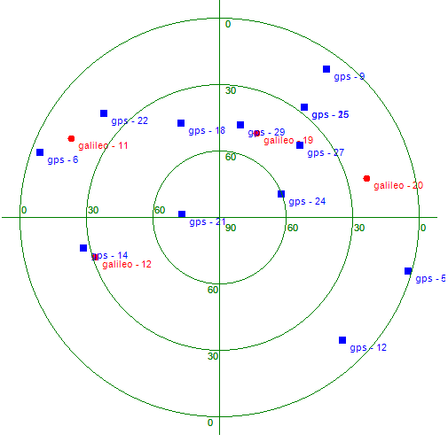
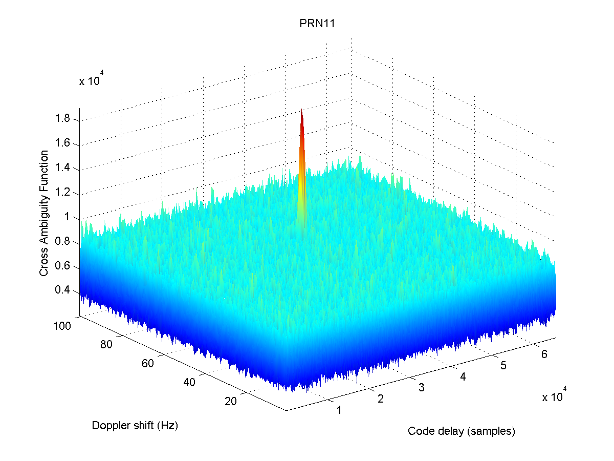
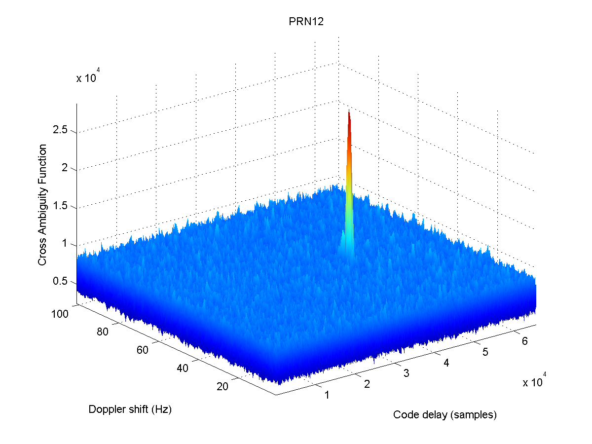
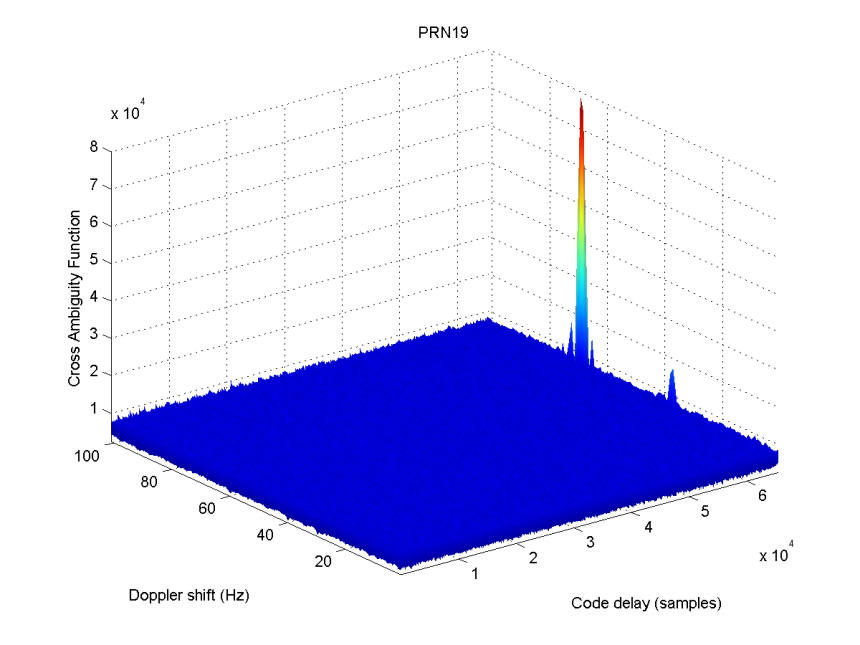
Figure 2 shows the positions of the four Galileo satellites and of 12 GPS satellites at time of acquisition, while Figure 3 reports the acquisition results of the four Galileo IOV satellites.
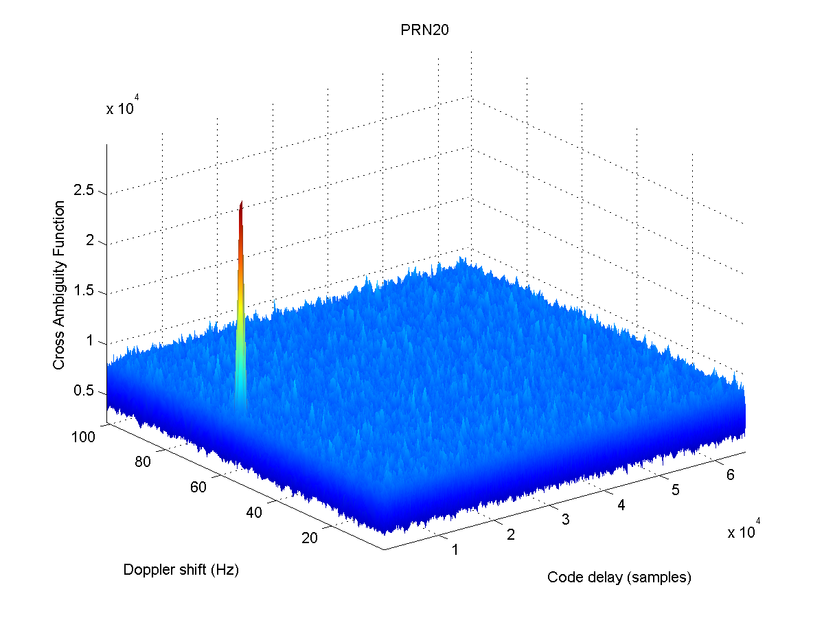
Figure 2. Skyplot of the satellites of the GPS and Galileo systems at the time of the campaign. The Galileo satellites are PFM (PRN11), FM2 (PRN12), FM3 (PRN19), and FM4 (PRN20).Figure 3. Acquisition results of the four Galileo IOV satellites: PRN 11.Figure 3. Acquisition results of the four Galileo IOV satellites: PRN12.Figure 3. Acquisition results of the four Galileo IOV satellites: PRN19.Figure 3. Acquisition results of the four Galileo IOV satellites: PRN20.
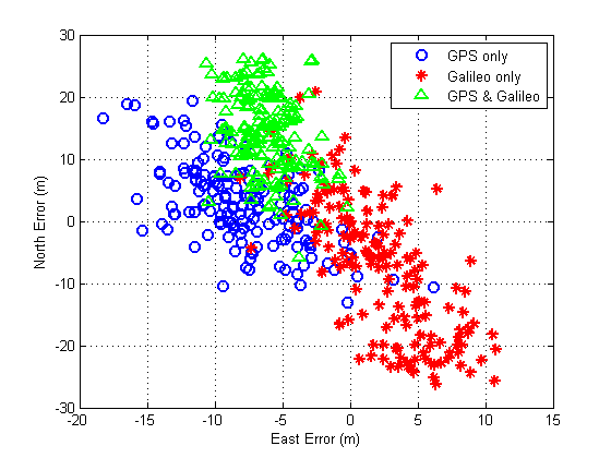
Comparison of the position computed using only Galileo, only GPS or both systems together is also presented in Figure 4. It should be noted that during the campaign, the data demodulation process reports that the Galileo system announces the “navigation data valid” status for PFM and FM3, meanwhile the “working without guarantee” for FM2 and FM4.
Figure 4. Position computed when using GPS only, Galileo only, or GPS+Galileo
The NAVIS Centre, located at the Hanoi University of Science and Technology in Hanoi, Vietnam, was established with a project co-funded by the European Union and collaborates with European and Asian partners on research and development of satellite navigation technology in Southeast Asia. This report was made by Dr. Ta Hai Tung, director of the NAVIS Centre, and Prof. Gustavo Belforte, co-director.
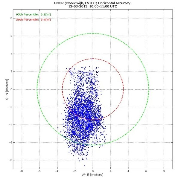
Measurements of individual Galileo horizontal position fixes performed for the first time using the four Galileo satellites in orbit plus the worldwide ground system between 1000 and 11:00 CET on Tuesday 12 March 2013, showing an overall horizontal accuracy over ESTEC in Noordwijk, the Netherlands, of 6.3 m.
Galileo Logs First Autonomous Fix; Galileo over Canada (By James T. Curran, Mark Petovello, and Gérard Lachapelle); and Indoor Nav: Early Steps towards FCC Standards
Galileo Logs First Autonomous Fix
Entitling its release “From Orbit with Love,” the European Space Agency (ESA) announced March 12 that the four current satellites of the Galileo constellation achieved their first autonomous position fix. The feat was replicated by the NavSAS group of Politecnico di Torino, by GNSS manufacturer Septentrio, and by a University of Calgrary team as the four satellites appeared over North America.
The obtained accuracy lies in the 10-meter range, according to ESA, adding that this fulfills expectations, considering the infrastructure is only partly deployed. The fix was obtained by ESA’s Netherlands navigation lab, using the four satellites, launched in October 2011 and 2012, and the Galileo programme’s ground infrastructure: control centers in Italy and Germany and a global network of ground stations.
With only four satellites for the time being, the full Galileo constellation is visible at the same time for a maximum two to three hours daily. This frequency will increase as more satellites join the constellation in orbit, along with extra ground stations coming online, for Galileo’s early services to start at the end of 2014.
With the validation testing activities under way, users might experience breaks in the content of the navigation messages being broadcast, said ESA. In the coming months the messages will be further elaborated to define the offset between Galileo System Time and Coordinated Universal Time (UTC), enabling Galileo to be relied on for precision timing applications, as well as the Galileo to GPS Time Offset, ensuring interoperability with GPS.
NavSAS Confirmation. Almost simultaneously with the ESA announcement, the NavSAS group of Politecnico di Torino and Istituto Superiore Mario Boella in Turin, Italy, also achieved a position fix using the signals of the four In-Orbit Validation satellites (PFM, FM2, FM3, FM4). NavSAS researchers computed the positions using full software receivers developed by the team.
Septentrio, Too. Septentrio became the first receiver manufacturer to report an autonomous real-time position calculation using Galileo IOV satellites with its own standard commercial receiver. The company based in Leuven, Belgium announced on March 12 that it performed standalone position calculated from in-orbit navigation messages using a standard PolaRx4 GNSS receiver equipped with commercially released firmware.
This achievement was followed by a further Septentrio release stating performance of what it believes to be the first 4-constellation PVT by a standard commercial receiver, on March 12 at approximately 10:35 UTC.
The milestone in all three accounts is that it is Galileo-only real-time positioning. Galileo positioning in post-processing mode was described by authors from the Technische Universität München and the German Space Operations Center, in a GPS World account, February 2012 issue.
Galileo over Canada
By James T. Curran, Mark Petovello, and Gérard Lachapelle
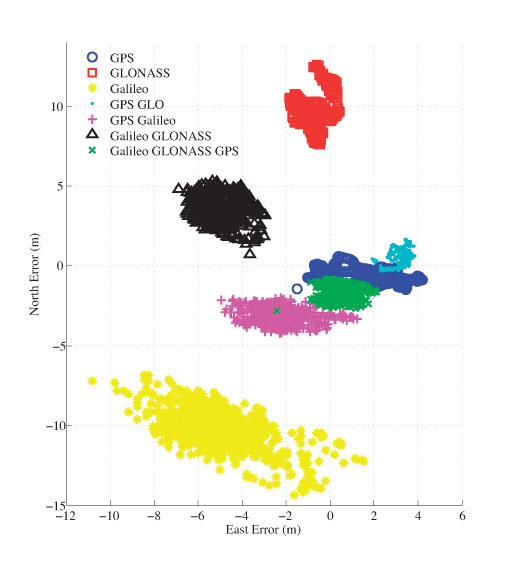
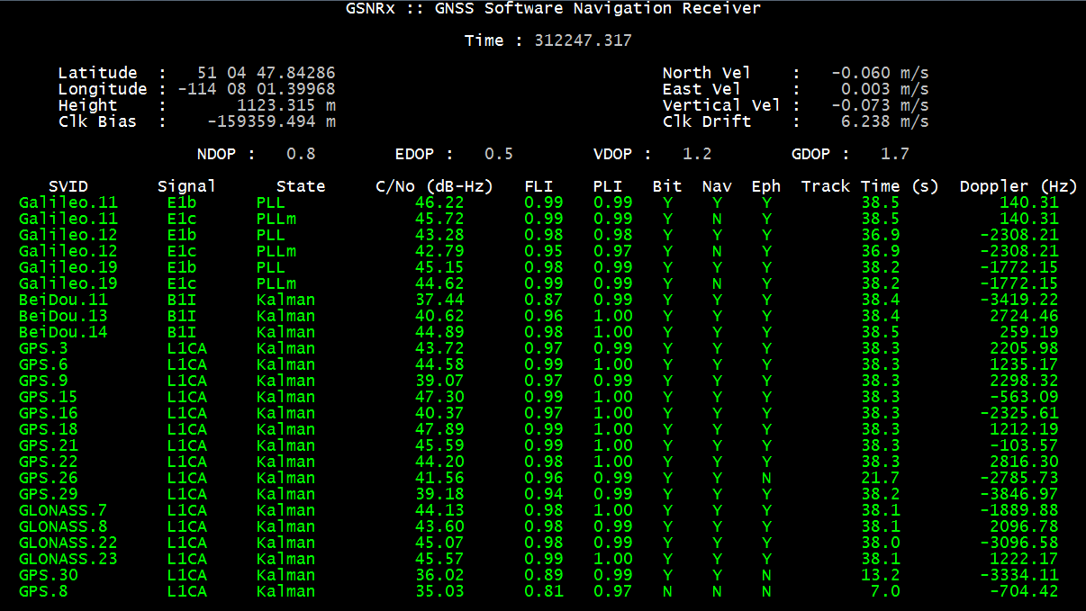
Within a day of activation over Europe, Galileo satellites were visible over North America. The PLAN Group of the University of Calgary captured and processed signals from Galileo PRN 11, 12, and 19 on E1B/C. The PLAN software GSNRx simultaneously tracked GPS L1 and GLONASS L1 for combined solutions in real time.
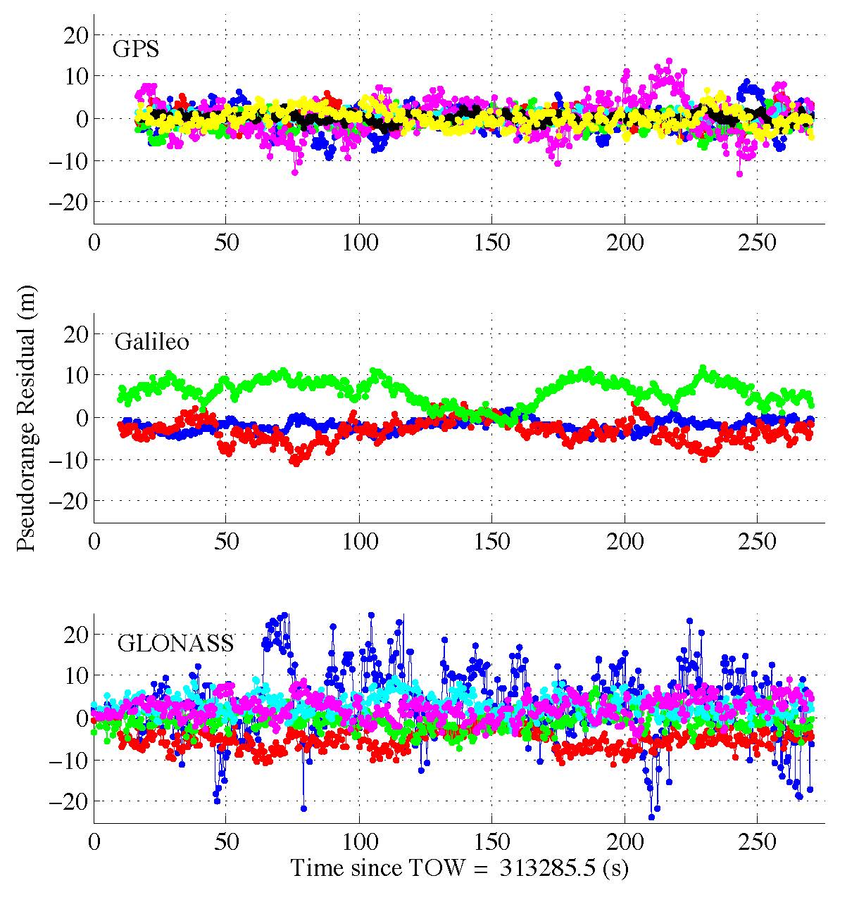
The Galileo navigation message on E1B stated that the satellite health status is flagged as E1BHS=3 meaning “Signal Component currently in Test” and the data validity status is flagged as E1BDVS=1 meaning “Working without guarantee.” Current Galileo-ready commercial receivers may automatically discard measurements from a satellites broadcasting such messages. Parsing the received words in the I/NAV message, more than 50 percent were of type 0, although all words (types 0 to 10) were decoded at some point during the test.
Figure 1. 2D position errors.
Data was collected using a roof-mounted NovAtel 702GG antenna and an in-house two-channel digitizing front-end clocked by a high quality OCXO, in addition to a three-channel National Instruments front-end for post-processing. The two-channel intermediate frequency data was streamed live to a laptop computer for real-time processing with GSNRx. The GPS and GLONASS signals were tracked using a Kalman-filter-based tracking strategy while the Galileo signals were tracked using a specialized data-pilot algorithm.
Pseudorange and Doppler observations were extracted from the tracking strategies at a rate of 2 Hz. Single-frequency single-point position solutions were then computed for each of the three systems, each of the three pairs of systems and for the full combined Galileo-GLONASS-GPS. In the case of the three-satellite Galileo solution, the height was held fixed. Figure 1 shows 2D position errors with respect to antenna ITRF coordinates. Departures of the solutions involving GLONASS are likely due to orbital biases, given location of Calgary with respect to GLONASS ground stations.
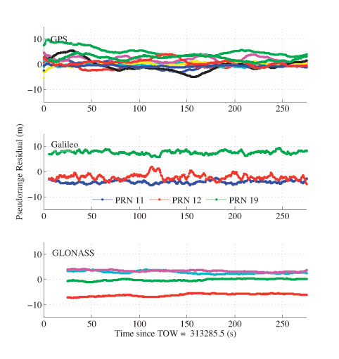
Figure 2. Pseudorange residuals.
Next, by fixing the known position in the solution and solving only for the three clock biases, accurate pseudorange residuals were computed and are shown Figure 2. Galileo PRN 19, launched a year later than PRN 11 and 12, exhibits larger residuals, perhaps attributable to ephemeris or orbital errors. The overall results show very good consistency of the Galileo results and the PLAN Group equipment and GSNRx receiver.
Indoor Nav: Early Steps towards FCC Standards
The Federal Communications Commission (FCC) on March 14 released two reports from its Communications Security, Reliability, and Interoperability Council (CSRIC): the “Indoor Location Test Bed Report,” and “Leveraging LBS and Emerging Location Technologies for Indoor Wireless E9-1-1.”
They report on Bay Area tests of technology from NextNav, Polaris Wireless, and Qualcomm, in four representative morphologies (dense urban, urban, suburban, rural) and various building types. They are available online, via env-gpsworld-integration.kinsta.cloud/csric, are the subject of an Expert Advice column (see page 10), and will be more fully discussed in May issue. For now, this summary from the first-named report:
“Seven location vendors/technologies began the process to demonstrate their performance indoors through the common test bed, but only three completed the process. Of these three, two technologies (AGPS/AFLT and RF Fingerprinting) are already in common use for emergency services, while the third (metropolitan beacons) is not yet commercially available. However all technologies tested demonstrated relativity high yield and various levels of accuracy in indoor environments.
“Significant standards work is required for practical implementation of many emerging location technologies for emergency services use.
“Many positioning methods require handset modifications. Integration of these modified handsets into the subscriber base, once the location technology is commercially available, will take years to complete.
“Progress has been made in the ability to achieve significantly improved search rings in both a horizontal and vertical dimension. However, even the best location technologies tested have not proven the ability to consistently identify the specific building and floor, which represents the required performance to meet Public Safety’s expressed needs. This is not likely to change over the next 12–24 months. Various technologies have projected improved performance in the future, but none of those claims have yet been proven through the test bed process. It is hoped that such technologies would be tested and validated in future test bed campaigns.”
An April 16 GPS World Webinar covers this topic with test participants. Registration is free.
ESA International Summer School on GNSS 2013 will take place this year in Davos, Switzerland, July 15-25, 2013, at the Schatzalp Snow & Mountain Resort.
Satellite navigation technology is changing all our lives — and here is your chance to gain an expert overview. This summer’s Navigation Summer School, hosted by the Swiss Space Office and the Swiss Space Center in Davos, Switzerland, will bring together top experts in the field with graduate students and young professionals. Registration is now open.
Activities equivalent to 6-7 percent of European GDP already depend on satnav services, equivalent to €800 billion in value, and Europe’s own Galileo system is anticipated to further boost satnav’s economic impact. The first four Galileo satellites are operational in orbit, with initial navigation services projected to begin at the end of next year.
But how does satellite navigation work in practice? July’s two-week International Navigation Summer School aims to give participants a comprehensive theoretical and practical overview of the field, from the basics of GNSS to signal reception and processing to determine the position-navigation-time solution.
The program is open to graduate students (with a first university degree), Ph.D. candidates, early-stage researchers and young professionals wishing to broaden their knowledge.
Lectures by internationally renowned specialists will be combined with practical exercises and lab work. Principles of project management, entrepreneurship and marketing will also be covered in detail, with the participants tasked to develop an innovation-based group project over the course of the event.
Pascal Rochat of Spectratime, CEO of the Swiss company that designed the atomic clocks at the heart of Galileo, will give the inaugural lecture.
ESA’s International GNSS Navigation Summer School takes place in cooperation with the Joint Research Center, EC, in Ispra, Stanford University, the Institut Supérieur de l’Aeronautique et de l’Espace in Toulouse, Graz University of Technology and University FAF Munich, with the support of the Swiss Space Office and the Swiss Space Center.
by James T. Curran, Mark Petovello, and Gérard Lachapelle
Within a day of their initial activation over central Europe on March 12, Galileo satellites were visible over North America. The PLAN Group of the University of Calgary was successful in capturing and processing the signals from these satellites as they emerged. Galileo PRN 11, 12, and 19 were found and tracked on E1B/C. The PLAN software GSNRx was also able to track simultaneously GPS L1 and GLONASS L1 and produce combined position solutions.
Examining the Galileo navigation message transmitted on the E1B signal, it was found that the satellite health status is flagged as E1BHS=3 meaning Signal Component currently in Test, and the data validity status is flagged as E1BDVS=1 meaning Working without Guarantee. Current Galileo-ready commercial receivers may automatically discard measurements from a satellites broadcasting such messages. Parsing the received words in the I/NAV message, it was noted that more 50 percent of them were of type 0, although all words (types 0 to 10) were decoded at some point during the test.
Data was collected using a roof-mounted NovAtel 702GG antenna and an in-house two-channel digitizing front-end clocked by a high quality OCXO and also a three-channel National Instruments front-end for post-processing. The two-channel intermediate frequency data was streamed live to a laptop computer for real-time processing with GSNRx. Two RF channels were processed, the first centered at 1574.0 MHz with an IF bandwidth of 10.0 MHz, for the GPS L1 C/A and Galileo E1B/C signals and the second centered at 1602.0 MHz again with a bandwidth of 10.0 MHz, for the GLONASS L1 OF signals. The GPS and GLONASS signals were tracked using a Kalman-filter-based tracking strategy while the Galileo signals were tracked using a specialized data-pilot algorithm.
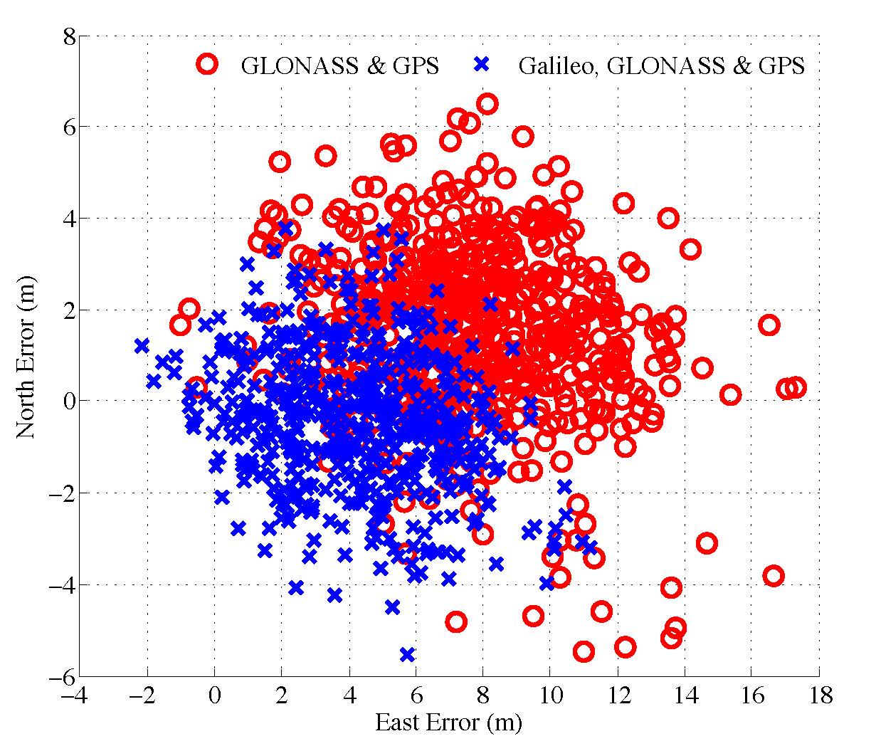
Figure 1. Scatter plot of the north and east position
Pseudorange and Doppler observations were extracted from the tracking strategies at a rate of 2 Hz. A 2D horizontal plot of the combined GPS & GLONASS and the combined Galileo, GLONASS & GPS single-frequency single-point solutions is presented in Figure 1.
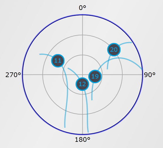
Figure 2: Skyplot of the Galileo satellites.
The pseudorange residuals are plotted against time for each PRN tracked from each of the three systems in Figure 3. It is apparent that the addition of the three Galileo observations contributes to a reduction in bias and standard deviation in the horizontal directions, showing an excellent functioning of the Galileo satellites and PLAN Group equipment and software.
Figure 3. Pseudorange residuals are plotted against time for each PRN tracked from each of the three systems.Figure 4. A screenshot of the receiver processing the data.